2026 ENSO Updates: CPC Febuary update= Neutral thru most of summer / El Niño for late summer

This is the general tropical discussion area. Anyone can take their shot at predicting a storms path.

Moderator: S2k Moderators

Forum rules

The posts in this forum are NOT official forecasts and should not be used as such. They are just the opinion of the poster and may or may not be backed by sound meteorological data. They are NOT endorsed by any professional institution or STORM2K. For official information, please refer to products from the National Hurricane Center and National Weather Service.

Help Support Storm2K
Message
Author
User avatar
Kingarabian
S2K Supporter
S2K Supporter
Posts: 16336
Joined: Sat Aug 08, 2009 3:06 am
Location: Honolulu, Hawaii

Re: 2026 ENSO Updates

#181 Postby Kingarabian » Sun Feb 08, 2026 11:26 pm

WeatherBoy2000 wrote:
Kingarabian wrote:FYI the PDO tends to warm during winter and early spring periods. Regardless of phase. But it would be a big step if we can see an actual positive reading soon.


According to NOAA, the pdo has actually gone further negative since December. January recorded a monthly reading of -1.19 vs -0.98 back in December:

https://www.ncei.noaa.gov/pub/data/cmb/ersst/v5/index/ersst.v5.pdo.dat

Whether this changes for Febuary remains to be seen, but the waters off Japan have been relentlessly warm for the past several years which has made any transition to a proper +pdo difficult.


We could see similar or warmer values over the next few months. But yeah the negative streak continues.
0 likes   
RIP Kobe Bryant

User avatar
Kingarabian
S2K Supporter
S2K Supporter
Posts: 16336
Joined: Sat Aug 08, 2009 3:06 am
Location: Honolulu, Hawaii

Re: 2026 ENSO Updates

#182 Postby Kingarabian » Sun Feb 08, 2026 11:27 pm

DorkyMcDorkface wrote:
WeatherBoy2000 wrote:
Kingarabian wrote:FYI the PDO tends to warm during winter and early spring periods. Regardless of phase. But it would be a big step if we can see an actual positive reading soon.


According to NOAA, the pdo has actually gone further negative since December. January recorded a monthly reading of -1.19 vs -0.98 back in December:

https://www.ncei.noaa.gov/pub/data/cmb/ersst/v5/index/ersst.v5.pdo.dat

Whether this changes for Febuary remains to be seen, but the waters off Japan have been relentlessly warm for the past several years which has made any transition to a proper +pdo difficult.

Yeah the stripe of warmth emanating from Japan is definitely muddling things a bit. We'll have to see if that fades eventually, then we'll likely start to see the PDO index approach positive levels.

Fwiw the CanSIPS, NMME and seasonal Euro actually show the "warm blob" persisting despite +PMM arising. It's a bit of a strange look, could continue to weigh the PDO index down if that's the case.
https://i.imgur.com/LSYr3xf.png
https://i.imgur.com/QFEc5SI.png
https://i.imgur.com/DSaobF2.png


Maybe something similar to 2023. A negative PDO due to the warm Japan waters but we still see an El Nino.
1 likes   
RIP Kobe Bryant

User avatar
DorkyMcDorkface
Category 4
Category 4
Posts: 973
Age: 28
Joined: Mon Sep 30, 2019 1:32 pm
Location: Mid-Atlantic

Re: 2026 ENSO Updates

#183 Postby DorkyMcDorkface » Sun Feb 08, 2026 11:30 pm

Kingarabian wrote:
DorkyMcDorkface wrote:
WeatherBoy2000 wrote:
According to NOAA, the pdo has actually gone further negative since December. January recorded a monthly reading of -1.19 vs -0.98 back in December:

https://www.ncei.noaa.gov/pub/data/cmb/ersst/v5/index/ersst.v5.pdo.dat

Whether this changes for Febuary remains to be seen, but the waters off Japan have been relentlessly warm for the past several years which has made any transition to a proper +pdo difficult.

Yeah the stripe of warmth emanating from Japan is definitely muddling things a bit. We'll have to see if that fades eventually, then we'll likely start to see the PDO index approach positive levels.

Fwiw the CanSIPS, NMME and seasonal Euro actually show the "warm blob" persisting despite +PMM arising. It's a bit of a strange look, could continue to weigh the PDO index down if that's the case.
https://i.imgur.com/LSYr3xf.png
https://i.imgur.com/QFEc5SI.png
https://i.imgur.com/DSaobF2.png


Maybe something similar to 2023. A negative PDO due to the warm Japan waters but we still see an El Nino.

Yeah I ultimately don't think it will significantly impede the transition to El Niño in the end. We're still well on track for one, the subsurface warmth/downwelling KW is too obvious to ignore at this point.
0 likes   
Please note the thougths expressed by this account are solely those of the user and are from a hobbyist perspective. For more comprehensive analysis, consult an actual professional meteorologist or meteorology agency.


Floyd 1999 | Isabel 2003 | Hanna 2008 | Irene 2011 | Sandy 2012 | Isaias 2020

User avatar
Kingarabian
S2K Supporter
S2K Supporter
Posts: 16336
Joined: Sat Aug 08, 2009 3:06 am
Location: Honolulu, Hawaii

Re: 2026 ENSO Updates

#184 Postby Kingarabian » Mon Feb 09, 2026 9:12 am

Image

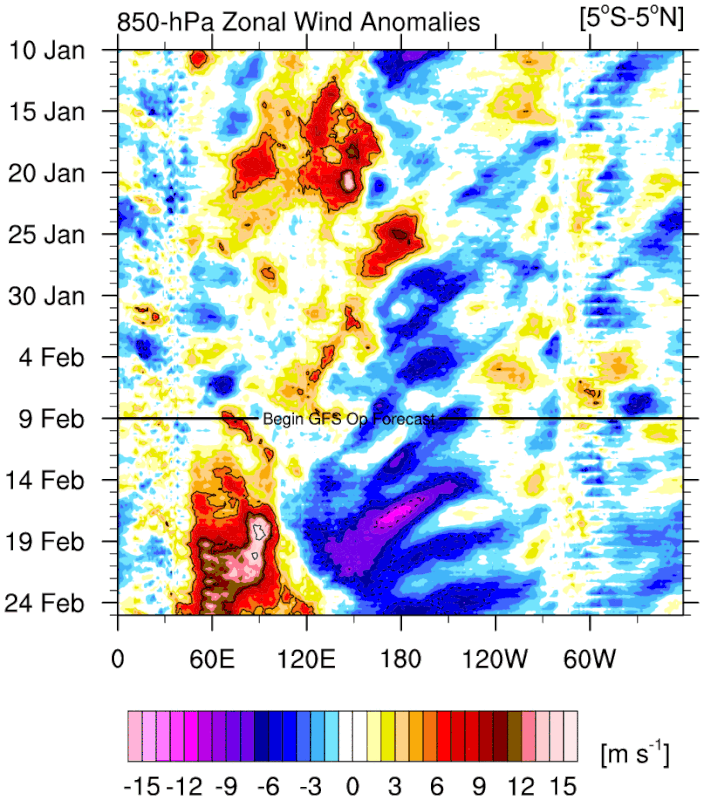
Looks like a substantial IO WWB in the forecast. Will be key to see it transition to the MC and the WPAC. CFS shows supports this in the MJO charts.
1 likes   
RIP Kobe Bryant

User avatar
cycloneye
Admin
Admin
Posts: 149032
Age: 69
Joined: Thu Oct 10, 2002 10:54 am
Location: San Juan, Puerto Rico

Re: 2026 ENSO Updates

#185 Postby cycloneye » Mon Feb 09, 2026 10:17 am

CPC weekly update of 2/9/26 has niño region 3.4 at -0.9C.

https://www.cpc.ncep.noaa.gov/products/ ... ts-web.pdf

Image
0 likes   
Visit the Caribbean-Central America Weather Thread where you can find at first post web cams,radars
and observations from Caribbean basin members Click Here

User avatar
Iceresistance
Category 5
Category 5
Posts: 9564
Age: 22
Joined: Sat Oct 10, 2020 9:45 am
Location: Tecumseh, OK/Norman, OK

Re: 2026 ENSO Updates

#186 Postby Iceresistance » Mon Feb 09, 2026 2:15 pm

I think the La Nina is almost dead
Image
https://s12.gifyu.com/images/bke7A.png
0 likes   
Bill 2015 & Beta 2020

Winter 2020-2021 :cold:

All observations are in Tecumseh, OK unless otherwise noted.

Winter posts are focused mainly for Oklahoma & Texas.

Take any of my forecasts with a grain of salt, refer to the NWS, SPC, and NHC for official information

Never say Never with weather! Because ANYTHING is possible!

User avatar
cycloneye
Admin
Admin
Posts: 149032
Age: 69
Joined: Thu Oct 10, 2002 10:54 am
Location: San Juan, Puerto Rico

Re: 2026 ENSO Updates

#187 Postby cycloneye » Mon Feb 09, 2026 4:46 pm

869MB wrote:
cycloneye wrote:The PDO factor.

 https://x.com/cyclonicwx/status/2020184495882932455


Due to these latest anomalies, I’ll be a little surprised if January’s PDO index results don’t flip to positive, even if it's just slightly. We should find out on this forthcoming Monday morning around 10AM.

And even if it does trend positive over the next couple of months, I’m beginning to have some doubts about what the atmospheric response will be for my region later this year going into 2027 even if we can achieve a +PDO/+ENSO combo later on this year after some of the discussions between Ntwx and USTropics a few pages back.


Still the january data has not come out in this site.

https://oceanview.pfeg.noaa.gov/erddap/ ... e?time,PDO
0 likes   
Visit the Caribbean-Central America Weather Thread where you can find at first post web cams,radars
and observations from Caribbean basin members Click Here

869MB
S2K Supporter
S2K Supporter
Posts: 175
Joined: Thu Feb 14, 2019 9:49 pm
Location: Katy, TX

Re: 2026 ENSO Updates

#188 Postby 869MB » Mon Feb 09, 2026 8:15 pm

cycloneye wrote:
869MB wrote:
cycloneye wrote:The PDO factor.

 https://x.com/cyclonicwx/status/2020184495882932455


Due to these latest anomalies, I’ll be a little surprised if January’s PDO index results don’t flip to positive, even if it's just slightly. We should find out on this forthcoming Monday morning around 10AM.

And even if it does trend positive over the next couple of months, I’m beginning to have some doubts about what the atmospheric response will be for my region later this year going into 2027 even if we can achieve a +PDO/+ENSO combo later on this year after some of the discussions between Ntwx and USTropics a few pages back.


Still the january data has not come out in this site.

https://oceanview.pfeg.noaa.gov/erddap/ ... e?time,PDO


Interesting stuff, because NOAA has clearly has updated their PDO chart with the -1.19 value for January 2026. https://www.ncei.noaa.gov/access/monitoring/pdo/
1 likes   

User avatar
cycloneye
Admin
Admin
Posts: 149032
Age: 69
Joined: Thu Oct 10, 2002 10:54 am
Location: San Juan, Puerto Rico

Re: 2026 ENSO Updates

#189 Postby cycloneye » Mon Feb 09, 2026 10:23 pm

3 likes   
Visit the Caribbean-Central America Weather Thread where you can find at first post web cams,radars
and observations from Caribbean basin members Click Here

User avatar
DorkyMcDorkface
Category 4
Category 4
Posts: 973
Age: 28
Joined: Mon Sep 30, 2019 1:32 pm
Location: Mid-Atlantic

Re: 2026 ENSO Updates

#190 Postby DorkyMcDorkface » Tue Feb 10, 2026 11:33 am

869MB wrote:
cycloneye wrote:
869MB wrote:
Due to these latest anomalies, I’ll be a little surprised if January’s PDO index results don’t flip to positive, even if it's just slightly. We should find out on this forthcoming Monday morning around 10AM.

And even if it does trend positive over the next couple of months, I’m beginning to have some doubts about what the atmospheric response will be for my region later this year going into 2027 even if we can achieve a +PDO/+ENSO combo later on this year after some of the discussions between Ntwx and USTropics a few pages back.


Still the january data has not come out in this site.

https://oceanview.pfeg.noaa.gov/erddap/ ... e?time,PDO


Interesting stuff, because NOAA has clearly has updated their PDO chart with the -1.19 value for January 2026. https://www.ncei.noaa.gov/access/monitoring/pdo/

Random observation but I never realize how low the index got last summer, it tanked to -4.21 in July! (lowest on record)
1 likes   

Please note the thougths expressed by this account are solely those of the user and are from a hobbyist perspective. For more comprehensive analysis, consult an actual professional meteorologist or meteorology agency.


Floyd 1999 | Isabel 2003 | Hanna 2008 | Irene 2011 | Sandy 2012 | Isaias 2020

User avatar
cycloneye
Admin
Admin
Posts: 149032
Age: 69
Joined: Thu Oct 10, 2002 10:54 am
Location: San Juan, Puerto Rico

Re: 2026 ENSO Updates

#191 Postby cycloneye » Tue Feb 10, 2026 11:39 am

Well, the other site updated today with January PDO at -0.85.

Image

https://oceanview.pfeg.noaa.gov/erddap/ ... e?time,PDO
1 likes   
Visit the Caribbean-Central America Weather Thread where you can find at first post web cams,radars
and observations from Caribbean basin members Click Here

869MB
S2K Supporter
S2K Supporter
Posts: 175
Joined: Thu Feb 14, 2019 9:49 pm
Location: Katy, TX

Re: 2026 ENSO Updates

#192 Postby 869MB » Tue Feb 10, 2026 12:37 pm

cycloneye wrote:Well, the other site updated today with January PDO at -0.85.

https://i.imgur.com/AsbCI1V.jpeg

https://oceanview.pfeg.noaa.gov/erddap/ ... e?time,PDO


Ok well that’s very interesting…So why the discrepancy with the two indexes?
0 likes   

User avatar
cycloneye
Admin
Admin
Posts: 149032
Age: 69
Joined: Thu Oct 10, 2002 10:54 am
Location: San Juan, Puerto Rico

Re: 2026 ENSO Updates

#193 Postby cycloneye » Wed Feb 11, 2026 8:54 am

Every new updated frames of this loop has the yellows and oranges expanding more and more.

Image
0 likes   
Visit the Caribbean-Central America Weather Thread where you can find at first post web cams,radars
and observations from Caribbean basin members Click Here

User avatar
cycloneye
Admin
Admin
Posts: 149032
Age: 69
Joined: Thu Oct 10, 2002 10:54 am
Location: San Juan, Puerto Rico

Re: 2026 ENSO Updates

#194 Postby cycloneye » Wed Feb 11, 2026 5:29 pm

Very long post by Dr Ben Noll about the RONI measurment of ENSO and the difference with the ONI.

 https://x.com/BenNollWeather/status/2021607661318369579


@BenNollWeather
There’s a new weather term in town that you'll want to get to know: Relative Niño Index!

As the world warms and sea temperatures rise, traditional monitoring methods for El Niño and La Niña are being supplemented with new techniques that are better suited to deal with that change.

The new term is the Relative Oceanic Niño Index (RONI), which compares ocean temperatures in the equatorial Pacific with the rest of the global tropics to determine how relatively warm or cool one area is compared to another. As the coverage of above-average ocean temperatures increases, it’s becoming more challenging to decipher what’s unusual and what’s not.

This new method helps forecasters better understand where tropical thunderstorms will be focused — which ultimately influence jet streams, high- and low-pressure cells and weather around the world.

NOAA recently announced a shift to this new index to monitor and forecast El Niño and La Niña: https://weather.gov/media/notification/ ... ve_ONI.pdf

Government climate agencies in Australia and New Zealand announced in 2024 and 2025 that they would be using this new index as part of their operational monitoring of El Niño and La Niña — becoming the first countries in the world to make such a change.

These shifts demonstrate that a changing global climate affects more than just air temperatures, rainfall and humidity, also leaving an imprint on the planet’s most significant drivers of climate variability — El Niño and La Niña.

Looking at February's forecast of the relative vs. traditional Niño 3.4 Index, we can see that while the traditional index switches to El Niño by May, the relative index lags behind.

This is because the global tropics are anomalously warm and are predicted to become even warmer — which mutes the El Niño signal in a relative sense.

I'll be referencing both the traditional and relative indices to help with forecasting, but ultimately the new relative indices should be better at detecting the onset and significance of impacts from El Niño and La Niña.
1 likes   
Visit the Caribbean-Central America Weather Thread where you can find at first post web cams,radars
and observations from Caribbean basin members Click Here

User avatar
cycloneye
Admin
Admin
Posts: 149032
Age: 69
Joined: Thu Oct 10, 2002 10:54 am
Location: San Juan, Puerto Rico

Re: 2026 ENSO Updates: Breaking news= CPC Febuary update= Neutral thru the summer / El Niño after that

#195 Postby cycloneye » Thu Feb 12, 2026 9:20 am

Breaking News

Big update and change from CPC with the RONI data.

 https://x.com/NWSCPC/status/2021947407643406449


https://www.cpc.ncep.noaa.gov/products/ ... disc.shtml

In summary, a transition from La Niña to ENSO-neutral is expected in February-April 2026 (60% chance), with ENSO-neutral likely persisting through the Northern Hemisphere summer (56% chance in June-August 2026;

Image
1 likes   
Visit the Caribbean-Central America Weather Thread where you can find at first post web cams,radars
and observations from Caribbean basin members Click Here

mixedDanilo.E
Tropical Depression
Tropical Depression
Posts: 98
Joined: Sun Nov 21, 2021 8:00 am
Location: NY

Re: 2026 ENSO Updates: Breaking news= CPC Febuary update= Neutral thru the summer / El Niño after that

#196 Postby mixedDanilo.E » Thu Feb 12, 2026 5:39 pm

cycloneye wrote:Breaking News

Big update and change from CPC with the RONI data.

 https://x.com/NWSCPC/status/2021947407643406449


https://www.cpc.ncep.noaa.gov/products/ ... disc.shtml

In summary, a transition from La Niña to ENSO-neutral is expected in February-April 2026 (60% chance), with ENSO-neutral likely persisting through the Northern Hemisphere summer (56% chance in June-August 2026;

https://i.imgur.com/7Uw6RxM.png


So you're telling me that this update now includes the RONI data?
0 likes   

mixedDanilo.E
Tropical Depression
Tropical Depression
Posts: 98
Joined: Sun Nov 21, 2021 8:00 am
Location: NY

Re: 2026 ENSO Updates: CPC Febuary update= Neutral thru the summer / El Niño after that

#197 Postby mixedDanilo.E » Thu Feb 12, 2026 5:40 pm

Image

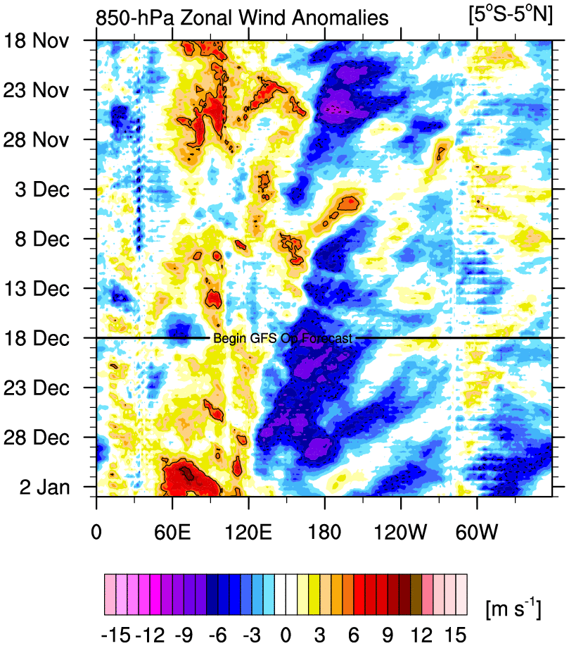
On another note, Latest hovmollers from the GFS indicate strong trade bursts til the end of the month...
0 likes   

User avatar
cycloneye
Admin
Admin
Posts: 149032
Age: 69
Joined: Thu Oct 10, 2002 10:54 am
Location: San Juan, Puerto Rico

Re: 2026 ENSO Updates: Breaking news= CPC Febuary update= Neutral thru the summer / El Niño after that

#198 Postby cycloneye » Thu Feb 12, 2026 5:55 pm

mixedDanilo.E wrote:
cycloneye wrote:Breaking News

Big update and change from CPC with the RONI data.

 https://x.com/NWSCPC/status/2021947407643406449


https://www.cpc.ncep.noaa.gov/products/ ... disc.shtml

In summary, a transition from La Niña to ENSO-neutral is expected in February-April 2026 (60% chance), with ENSO-neutral likely persisting through the Northern Hemisphere summer (56% chance in June-August 2026;

https://i.imgur.com/7Uw6RxM.png


So you're telling me that this update now includes the RONI data?


That is right.
1 likes   
Visit the Caribbean-Central America Weather Thread where you can find at first post web cams,radars
and observations from Caribbean basin members Click Here

869MB
S2K Supporter
S2K Supporter
Posts: 175
Joined: Thu Feb 14, 2019 9:49 pm
Location: Katy, TX

Re: 2026 ENSO Updates

#199 Postby 869MB » Thu Feb 12, 2026 10:56 pm

DorkyMcDorkface wrote:
869MB wrote:
cycloneye wrote:
Still the january data has not come out in this site.

https://oceanview.pfeg.noaa.gov/erddap/ ... e?time,PDO


Interesting stuff, because NOAA has clearly has updated their PDO chart with the -1.19 value for January 2026. https://www.ncei.noaa.gov/access/monitoring/pdo/

Random observation but I never realize how low the index got last summer, it tanked to -4.21 in July! (lowest on record)


Oh yeah last month I posted on the Texas Thread how you have to go back to September 2019 to find a month when the PDO was greater than 0.00. And 2015 was the last calendar year where every month’s value was greater than 0.00 from January to December.
0 likes   


Return to “Talkin' Tropics”

Who is online

Users browsing this forum: No registered users and 85 guests