Texas Spring 2026
Moderator: S2k Moderators
Forum rules

The posts in this forum are NOT official forecast and should not be used as such. They are just the opinion of the poster and may or may not be backed by sound meteorological data. They are NOT endorsed by any professional institution or STORM2K.
-
wxman22

- Category 5

- Posts: 1964
- Joined: Mon Jan 30, 2006 12:39 am
- Location: Wichita Falls, TX
- Contact:
Re: Texas Spring 2026
I think its safe to say that we are starting to see the affects of the transition to El Nino that is currently taking place.It's still a ways out but models are showing a classic Plains severe weather setup late next week into the following week.With multiple lee side cyclones developing.And an active subtropical jet and dryline.Flooding may also become more of a concern. Looks like April is going to be a busy month.
2 likes
-
Stratton23
- Category 5
- Posts: 3567
- Joined: Fri Jul 21, 2023 10:59 pm
- Location: Katy, Tx
Re: Texas Spring 2026
just got a call about 10 minutes ago from my mom and aunt in Longview, TX, told me the tornado siren went off in the city, can anyone confirm is their was an actual tornado on the ground via radar?
0 likes
Re: Texas Spring 2026
No it was radar indicated only…
541
WFUS54 KSHV 041654
TORSHV
TXC183-423-041745-
/O.NEW.KSHV.TO.W.0029.260404T1654Z-260404T1745Z/
BULLETIN - EAS ACTIVATION REQUESTED
Tornado Warning
National Weather Service Shreveport LA
1154 AM CDT Sat Apr 4 2026
The National Weather Service in Shreveport has issued a
* Tornado Warning for...
Southwestern Gregg County in northeastern Texas...
East Central Smith County in northeastern Texas...
* Until 1245 PM CDT.
* At 1154 AM CDT, a severe thunderstorm capable of producing a
tornado was located 10 miles north of Arp, or 12 miles northeast of
Whitehouse, moving northeast at 20 mph.
HAZARD...Tornado.
SOURCE...Radar indicated rotation.
IMPACT...Flying debris will be dangerous to those caught without
shelter. Mobile homes will be damaged or destroyed. Damage
to roofs, windows and vehicles will occur. Tree damage is
likely.
* Locations impacted include...
Kilgore, Clarksville City and Liberty City.
PRECAUTIONARY/PREPAREDNESS ACTIONS...
Move to an interior room on the lowest floor of a well-built building
away from windows. If you are outdoors, in a mobile home, or in a
vehicle, move to the closest substantial shelter and protect yourself
from flying debris.
&&
LAT...LON 3231 9513 3239 9517 3253 9489 3242 9479
3237 9494 3237 9499 3236 9499
TIME...MOT...LOC 1654Z 237DEG 19KT 3236 9509
TORNADO...RADAR INDICATED
MAX HAIL SIZE...0.00 IN
0 likes
-
txtwister78

- Category 5
- Posts: 2214
- Joined: Wed Jan 30, 2019 12:56 pm
- Location: San Antonio
Re: Texas Spring 2026
wxman22 wrote:I think its safe to say that we are starting to see the affects of the transition to El Nino that is currently taking place.It's still a ways out but models are showing a classic Plains severe weather setup late next week into the following week.With multiple lee side cyclones developing.And an active subtropical jet and dryline.Flooding may also become more of a concern. Looks like April is going to be a busy month.
Instability definitely won't be a problem with that setup either from the looks of it right now so I agree...expecting those dynamics to be much more favorable for severe storms late next week and beyond. Climatology/analogs support it with this tyoe of transition.
I mentioned a few weeks ago the signs were definitely there for an active April and that is now coming to fruition. To be clear that will include many regions across the state and not limited to just one area either.
My only concern is we don't get too much of a good thing too quickly regarding rainfall. I imagine for some that may become an issue down the road
0 likes
-
TomballEd
- Category 5
- Posts: 1298
- Age: 62
- Joined: Wed Aug 16, 2023 4:52 pm
- Location: Spring/Klein area, not Tomball
Re: Texas Spring 2026
Closer to home, the line from SAT to CLL looks like it is being undercut by outflow, unless the small showers ahead of the line can organize themselves, I expect little to no severe weather in SETX (HGX CWA) 
RAP forecast sounding shows plenty of CAPE (near 2000 J/Kg mixed layer) when the showers/storms approach but only 20 knots of deep shear so probably a continuation of storms being undercut immediately by the outflow.
HRRR shows a few cells trying to form ahead of the cold front and a few decent cells embedded in the line of showers. I expect some noise but nothing huge. HRRR totals show a big variation in rainfall totals, even locally, some places will exceed an inch while a lot of places get less than two tenths. I'm hoping on the 'long range models show rain' but long range models less than 2 weeks ago showed some decent rain for SETX, so until we get within a few days of next weekend and beyond, I'm going to expect lots of promise but not lots of rain.
Euro was wetter for the 2 weeks now, the GFS was closer to being correct until it started looking more Euro is, so I consider both models as failures here. Again, 0Z Euro is wetter, GFS is drier and I expect even GFS to overpromise locally. Signal for some flash flooding in the Hill Country to NC Texas still there next weekend/early the following week, they have been getting closer to forecast totals so that is something to watch.
0 likes
-
Ralph's Weather
- S2K Supporter

- Posts: 3374
- Age: 38
- Joined: Fri Dec 13, 2013 11:55 am
- Location: Lindale, TX
- Contact:
Re: Texas Spring 2026
Lindale is on the fringes of SHV and FTW radars so these low level rotations are missed around here.
1 likes
Follow on Facebook at Ralph's Weather.
-
Ralph's Weather
- S2K Supporter
- Posts: 3374
- Age: 38
- Joined: Fri Dec 13, 2013 11:55 am
- Location: Lindale, TX
- Contact:
Re: Texas Spring 2026
wxman22 wrote:Theres video confirming the Lindale tornado.
I was outside during it and had no idea it was there. It had to have been within 2 miles of me at the time. No wind at our house.
0 likes
Follow on Facebook at Ralph's Weather.
-
txtwister78
- Category 5
- Posts: 2214
- Joined: Wed Jan 30, 2019 12:56 pm
- Location: San Antonio
Re: Texas Spring 2026
Well would you look at that...nice soaking rain for portions of the Houston metro and east Texas ongoing? Seems a little too quiet in here now. 
Across SC TX 1-2 inches of rain fell across San Antonio with scattered showers and a few storms continuing to move on through the area. The jackpot winner today is just to our SW between Natalia and Lytle with radar estimates between 4-5 inches with more rain ongoing.
Not bad for "areas that don't see rain" I'd say. Much more on the way folks!
1 likes
-
South Texas Storms

- Professional-Met

- Posts: 4261
- Joined: Thu Jun 24, 2010 12:28 am
- Location: Houston, TX
Re: Texas Spring 2026
txtwister78 wrote:Well would you look at that...nice soaking rain for portions of the Houston metro and east Texas ongoing? Seems a little quiet in here now.
Across SC TX 1-2 inches of rain fell across San Antonio with scattered showers and a few storms continuing to move on through the area. The jackpot winner today is just to our SW between Natalia and Lytle with radar estimates between 4-5 inches with more rain ongoing.
Not bad for "areas that don't see rain" I'd say. Much more on the way folks!
Yep, rainfall coverage and amounts were a little higher than I expected today. Think we're starting to see the effects of the developing El Nino event which is great to see. Should just be the start of what is hopefully an extended wet stretch across the state.
2 likes
-
Stratton23
- Category 5
- Posts: 3567
- Joined: Fri Jul 21, 2023 10:59 pm
- Location: Katy, Tx
Re: Texas Spring 2026
Meh, this line was underwhelming at least for my area, recorded under a quarter inch in total, glad other folks got good rains, but man this was a disappointment for my backyard
0 likes
-
txtwister78
- Category 5
- Posts: 2214
- Joined: Wed Jan 30, 2019 12:56 pm
- Location: San Antonio
Re: Texas Spring 2026
Stratton23 wrote:Meh, this line was underwhelming at least for my area, recorded under a quarter inch in total, glad other folks got good rains, but man this was a disappointment for my backyard
Looks like rain is still falling across that area per radar? Nice line going through Houston now. Might want to wait just a bit longer for complete totals.
But when you're in a drought it all counts even if you don't get the amounts you want in your own backyard. Those area creeks and tributaries benefit even if the grass in your backyard doesn't.
More on the way next week though so more chances to cash in
0 likes

Re: Texas Spring 2026
.42” here so far. Slow, soaking rains is exactly what we ordered. HRRR yesterday had more overnight and into tomorrow, but looks to have moved that disturbance south. Wouldn’t be surprised to see another 1/4” to 1/2” down here through early tomorrow.
Perfect weather for Easter IMO. Kiddos baskets will be ready to go and an egg hunt if weather permits. Pork butt going on the offset stick burner later tonight using apple wood to enjoy tomorrow afternoon. Happy Easter!
Perfect weather for Easter IMO. Kiddos baskets will be ready to go and an egg hunt if weather permits. Pork butt going on the offset stick burner later tonight using apple wood to enjoy tomorrow afternoon. Happy Easter!
1 likes

Re: Texas Spring 2026
3.72" plus another tornado warning (I think #4 for the year, no touchdowns though).
Beautiful week ahead with highs mainly in the 70's. Happy Easter!
Beautiful week ahead with highs mainly in the 70's. Happy Easter!
0 likes
-
Brent
- S2K Supporter
- Posts: 38760
- Age: 37
- Joined: Sun May 16, 2004 10:30 pm
- Location: Tulsa Oklahoma
- Contact:
Re: Texas Spring 2026
Dipped into the 30s for a minute here 
The GFS actually had a snow map last night
The GFS actually had a snow map last night
0 likes
#neversummer

-
Edwards Limestone

- S2K Supporter
- Posts: 514
- Age: 36
- Joined: Tue Dec 28, 2021 11:05 am
- Location: Smithson Valley, TX
Re: Texas Spring 2026
Ended up with over an inch IMBY from yesterday’s rains. Convection really fired over Comal County with the frontal passage which was so nice to see!
Looks like some more might be on the way today. Keep it going!
Looks like some more might be on the way today. Keep it going!
1 likes
The above post is NOT an official forecast and should not be used as such. It is just the opinion of the poster and may or may not be backed by sound meteorological data. It is NOT endorsed by any professional institution including Storm2k. For official information, please refer to NWS products.
-
wxman22
- Category 5
- Posts: 1964
- Joined: Mon Jan 30, 2006 12:39 am
- Location: Wichita Falls, TX
- Contact:
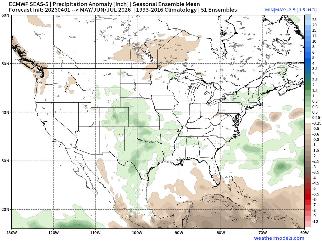
Re: Texas Spring 2026
Euro Weeklies for May/June/July. A wet signal is clearly showing up in the Plains. MCS season is probably going to be active this year.
1 likes
-
Stratton23
- Category 5
- Posts: 3567
- Joined: Fri Jul 21, 2023 10:59 pm
- Location: Katy, Tx
Re: Texas Spring 2026
Happy easter folks! Love that nice chill in the air, it feels incredible , nice to not feel like absolute death outside for once haha
0 likes


Re: Texas Spring 2026
wxman22 wrote:Euro Weeklies for May/June/July. A wet signal is clearly showing up in the Plains. MCS season is probably going to be active this year.
https://i.postimg.cc/g08XYXRG/seas5-qpfa-3mon-conus-MJJ.png
CANSIPs and CFS was already showing this look since early March. Good to see the Euro suite follow. I'm thinking a wetter, near normal summer.
Super duper not worth a dime yet CFSv2 monthlies for winter looks like the strong El Nino composite, GOA trough into the southwest and southern US which is typical of these ENSO events. They are unlikely to see bitter cold arctic air but stormy.


2 likes
The above post and any post by Ntxw is NOT an official forecast and should not be used as such. It is just the opinion of the poster and may or may not be backed by sound meteorological data. It is NOT endorsed by any professional institution including Storm2k. For official information, please refer to NWS products.
Help support Storm2K!
Return to “USA & Caribbean Weather”
Who is online
Users browsing this forum: 869MB, cheezyWXguy, Cpv17, SnowyOwl31, Stratton23, wxman22 and 116 guests