Tonight's EURO, puzzling ... daily SOI remains at 44.30.

Winter Weather Discussion

Moderator: S2k Moderators

Forum rules

The posts in this forum are NOT official forecast and should not be used as such. They are just the opinion of the poster and may or may not be backed by sound meteorological data. They are NOT endorsed by any professional institution or STORM2K.

Help Support Storm2K
Message
Author
User avatar
Stormsfury
Category 5
Category 5
Posts: 10549
Age: 53
Joined: Wed Feb 05, 2003 6:27 pm
Location: Summerville, SC

Tonight's EURO, puzzling ... daily SOI remains at 44.30.

#1 Postby Stormsfury » Tue Dec 23, 2003 9:24 pm

First of all, drives/poke a strong Southeastern Ridge after Day 4. The recent strong positive SOI of 44.30 still remains at 44.30 today, indicating the potential for strong blocking across the world. The EURO responds in the next 10 days showing such an event with many cutoff features across the globe. But is this scenario correct?

EURO Day 8-10 3 day average.

The models continue to advertise arctic cold building in NW Canada but how and where does this arctic air get transported down, if at all.

First, the run shows NO ridging in Japan (or Korea). Not generally good for transporting AC into the states.

Second, the AO (The Arctic Oscillation) going very negative. Good for transporting AC down.

Third, Ridge/Trough/Ridge couplet in the Atlantic Ocean, but NOT where it's prime for a NEG NAO pattern. In fact, it's POS on this depiction. Not good for locking down cold air in the East, and NOT generally conducive for snowstorms. In fact, the EURO's depiction on this run is a blowtorch for the East/Southeast.

Is the EURO mishandling the Split flow? IMHO, yes. The Canadian/GFS/NOGAPS Ensembles don't support this strong SE ridge.

NOGAPS Ensembles Day 10.
Image

Canadian Ensembles Day 10.
Image

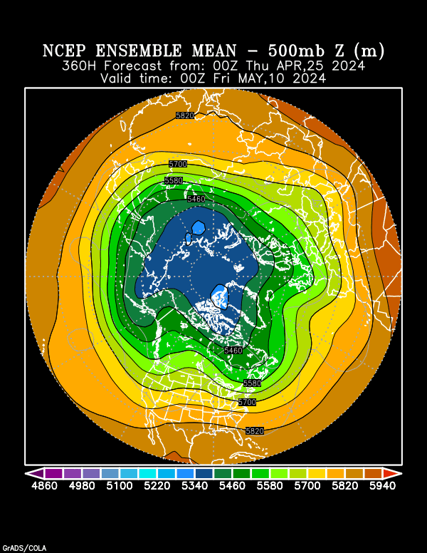
12z GFS Ensembles Day 10.
Image

Assuming that the overall idea is correct from the EURO and the global ensembles (00z run of the GFS ensembles) advertise ... cold air is coming, just not quite as soon as originally expected.

GFS ensemble loop

Image
0 likes   

Anonymous

#2 Postby Anonymous » Tue Dec 23, 2003 10:52 pm

If the Blowtorch verifies, you can see why I was so concerned about us enjoying such a cold, downright January-like December.

I've personally experienced over the past 30 years, that when December is unusually cold AND the preceding summer was both cool and unusually wet, that Jan and Feb tend to balance things out. They tend to be avg cold or milder, and considerably drier.

However I fervently hope that I prove to be very, very wrong. It would sure be nice to see a record or near-record cold Jan-Feb period with tons of crippling snows.

JEB
0 likes   

Valkhorn
Category 1
Category 1
Posts: 492
Joined: Wed Sep 10, 2003 4:09 am
Contact:

#3 Postby Valkhorn » Tue Dec 23, 2003 11:09 pm

I disagree. I think arctic air is definately on its move southward in January and I doubt the models will pick up on it until later.

Actually a Trough in Japan, one in Europe, and one near the Caspian would be CONDUSIVE for a trough in the East, would it not?
0 likes   

Anonymous

#4 Postby Anonymous » Tue Dec 23, 2003 11:16 pm

Yup, Bring on that Arctic air!!!!!!!!!!!!!!!!!!!!!!!!!!!!!!!!!
0 likes   

User avatar
Stormsfury
Category 5
Category 5
Posts: 10549
Age: 53
Joined: Wed Feb 05, 2003 6:27 pm
Location: Summerville, SC

#5 Postby Stormsfury » Tue Dec 23, 2003 11:46 pm

Valkhorn wrote:I disagree. I think arctic air is definately on its move southward in January and I doubt the models will pick up on it until later.

Actually a Trough in Japan, one in Europe, and one near the Caspian would be CONDUSIVE for a trough in the East, would it not?


Yes, in the longer term it SHOULD be. Remember, these are only out to Day 10. The 00z GFS ensemble run (out to 16 days) does indicate that a massive ridge develops and extends north of Alaska. But we've seen these setups before. But we haven't seen the SOI indices soar this high in several years either.

We have a variable situation here, and the EURO is probably missing at some point, undercutting s/w energy under the ridge. Another detail is WHERE the arctic air dumps itself. Does it drop straight into the Central US and spread east, lock itself in the Central US. Is it unable to lock down over the East due to a POS NAO, or is the EURO missing the teleconnections?

Like I said before, its a puzzling run of the EURO and has left more questions than answers, only to be answered later in time. But IMHO, the cold air is coming, it just looks to be a little bit delayed.

SF
0 likes   

Valkhorn
Category 1
Category 1
Posts: 492
Joined: Wed Sep 10, 2003 4:09 am
Contact:

#6 Postby Valkhorn » Wed Dec 24, 2003 1:48 am

I agree to that Storms... I think though that maybe because the SOI is so danged high it's really throwing some models for a loop. I mean WE know what a SOI that high could mean but the models, have they ever taken a number like that into account before?

My guess is they have never had that kind of a number before so therefore we don't know how well they'll do with it. The models could just be going crazy.
0 likes   


Return to “Winter Weather”

Who is online

Users browsing this forum: No registered users and 9 guests