Yes this is very true and indeed has some support from the AGCM climate model.

Notice how the warm pool shifts eastward overtime and the warm plume becomes re-established in the eastern equatorial pacific.
The following figure shows current sub-surface water temperature means and anomalies:
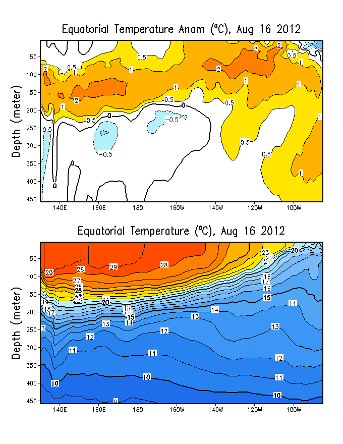
The strongest sub-surface warm anomalies continue to be located in the western tropical pacific...Notice also the relatively shallow depth of the +20C isotherm across the eastern pacific Nino regions which is NOT favorable for the eastward expansion of the warm pool in the western equatorial regions.
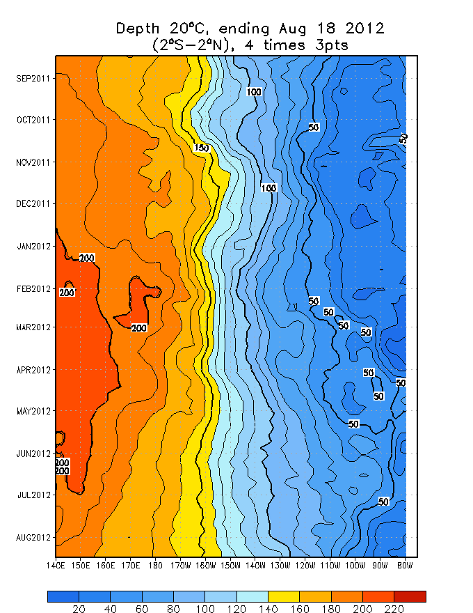
heres another look at the 20C isotherm depth in a time-longitude section of the equatorial pacific:
Typically weak El Nino events in the long-term cold cycle of the PDO are centered further west in the Equatorial pacific as a function of the large scale SSTA set up in the paciifc during the cold phase of the PDO.
the following figures shows the PDO phases in relation to El Nino and La Nina events:
http://tao.atmos.washington.edu/pdo/img ... m_cool.jpg
http://tao.atmos.washington.edu/pdo/img ... _cool2.jpg
Notice who the SSTA configuration particular to El Nino events corresponds well to the PDO long term warm phase. the same as the SSTA configuration particular to La Nina is most consistent with the PDO long term cold phase.
One must also understand the PDO displays quite a bit of interseasonal variability --- thus much like now...one can have a positive (warm) phase PDO for a short period of tie within the long-term...decadal and multi-decadal scale cold cycles.
Currently the PDO is in a short term warm cycle within the longer term cold cycle (entered in 1998). as a result --- this is much of the reason why last winters moderate El Nino was located further WEST in the Nino 3.0... 3.4 and 4.0 regions as compared to a classic El Nino in the long-term warm phase which is normally centered closest to the South American Coast (in the Nino 1+2 region).
For this reason im NOT convined that an El Nino the likes of wha the EMC model has been indicating can develop this spring given the PDO phase. Time will tell what IF any effect it will have on the atlantic tropical season.
At the present time...we are dealing with slightly warm ENSO neutral conditions. the ONLY area in the tropical paciifc where El Nino critera (+0.5C) has been acheived for any sustainable amouint of time is in the NINO 4.0 region near the dateline:
the eastern PAC NINO regions remain near normal.
IF the warm plume should begin to develop near the south american coast this spring...one may be able to expect MJO activity to decrease...and be LESS of a moderating factor on the 2004 tropical season.
as for the present with the current SSTA set-up the fluctuations in the MJO will continue to make for much variability in the PAC jet the remainder of the winter. At this point given this and the QBO...I doubt we will see the PAC jet relax anytime soon.
the final figure shows Global OLR anomalies:
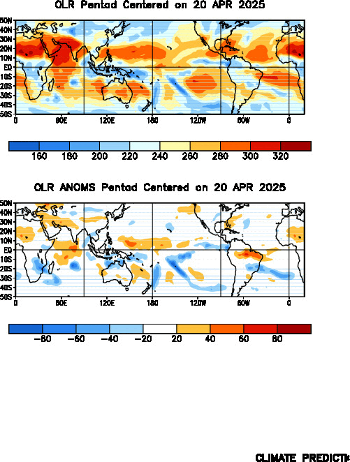
Notice the very low OLR values across the western tropical pacific which correspond well to increased convection and above normal precipitation.
 The posts in this forum are NOT official forecast and should not be used as such. They are just the opinion of the poster and may or may not be backed by sound meteorological data. They are NOT endorsed by any professional institution or


