Question about that Kelvin (sp?) wave
Moderator: S2k Moderators
Forum rules
 The posts in this forum are NOT official forecast and should not be used as such. They are just the opinion of the poster and may or may not be backed by sound meteorological data. They are NOT endorsed by any professional institution or STORM2K.

The posts in this forum are NOT official forecast and should not be used as such. They are just the opinion of the poster and may or may not be backed by sound meteorological data. They are NOT endorsed by any professional institution or STORM2K.
-
weatherlover427
Question about that Kelvin (sp?) wave
What are the implications of this big Kelvin (sp?) wave on the weather for the southwestern US this year? :-?  If it's too early to tell I understand.
0 likes
-
FLguy

- Professional-Met

- Posts: 799
- Joined: Mon Dec 29, 2003 5:36 pm
- Location: Daytona Beach FL
- Contact:
Joshua21Young wrote:What are the implications of this big Kelvin (sp?) wave on the weather for the southwestern US this year? :-?
it depends on where the areas of enhanced and spressed convection are located which relate best to where the heaviest precipitation is likely to occur along the west coast.
though that said the strongest correlation between the MJO and heavy precipitation is across the pacific northeast (which ties the ENSO phase into MJO activity...where El Nino events see LESS in the way of MJO activity corresponding to less precipitation across the pacific northwest during those periods...and enhanced precipitation in la nina winters where the PAC jet is more variable and MJO activity more prevalent).
Normally prior to significant precipitation events...the heaviest convection related to the MJO is located back across indonesia (~120E) and supressed convection over the indian ocean and the central pacific.
this is shown well by areas of above and below normal anomalous OLR (outgoing Longwave radiation) shown in the figure below:

notice the area of above normal OLR anomalies across the indian ocean indicative of supressed convection with below normal OLR anomalies further east corresponsing to increrased convection. this set-up observed currently is most favorable for a heavy precipitation event in the PAC northwest as compared to areas further south. though even now as the waves of increased and decreased convection shift around...we are losing that correlation as well.
the area of increased convection would have to be located between roughly 160E and 170E for the correspondence between the MJO and a major precipitation event across the southwest US to be the strongest. even what that said as i talked about previously the connection between MJO activity and heavy precipitation events is LESS the further south along the west coast one goes.
Just recently a STRONG kelvin wave has moved eastward out of indonesia and is heading east across the equatorial pacific which is associated with enhanced convection...shown in the figure below:

Notice the location of the wave is near 180 (the dateline) which as it continues east would be more favorable for heavy precipitation across the southwest. Even given the decreased connection.
suffice to say that the further east the area of convection associated with the MJO is located the better the potential for heavy precipitation events across the southwest USA is.
0 likes
-
weatherlover427
-
weatherlover427
-
Stephanie

- S2K Supporter

- Posts: 23843
- Age: 63
- Joined: Thu Feb 06, 2003 9:53 am
- Location: Glassboro, NJ
FLguy wrote:Stephanie wrote:It looks like a bulleye! You can't miss it. I hope that the southwest does benefit from this moisture, but in the same respect, I hope we won't be hearing about more mudslides in California!
it all depends on how much moisture gets involved
The graph that you have posted - that measures the temperature of the cloud tops right? I know that would indicate the strength of the wave, but it wouldn't necessarily determine the amount of moisture?
0 likes
-
FLguy
- Professional-Met
- Posts: 799
- Joined: Mon Dec 29, 2003 5:36 pm
- Location: Daytona Beach FL
- Contact:
Stephanie wrote:FLguy wrote:Stephanie wrote:It looks like a bulleye! You can't miss it. I hope that the southwest does benefit from this moisture, but in the same respect, I hope we won't be hearing about more mudslides in California!
it all depends on how much moisture gets involved
The graph that you have posted - that measures the temperature of the cloud tops right? I know that would indicate the strength of the wave, but it wouldn't necessarily determine the amount of moisture?
yes it indicates the temperatures of the cloud tops. the colors(blues...yellows and reds) correspond to colder/higher cloud tops whereas the gray shading translates to lower and warmer cloud tops. the green and brown lines indicate areas of enhanced (green) and decreased (brown) moisture and convection.
areas of increased convection correspond to less outgoing longwave radiation or OLR which is depicted in the first figure of my post in blue(due to the colder cloud tops)
decreased convection corresponds more OLR...which is shown in the yellows and reds.
0 likes
-
FLguy
- Professional-Met
- Posts: 799
- Joined: Mon Dec 29, 2003 5:36 pm
- Location: Daytona Beach FL
- Contact:
Stephanie wrote:Thanks Flguy! I didn't know what the green/brown lines were.
If anything, there's mositure all out ahead of that wave, so we could be seeing a good soaker from it.
i wouldint be so concerned with whats ahead of it...its the wave its self that has the biggest implications on the pattern downstream
0 likes
-
weatherlover427
-
FLguy
- Professional-Met
- Posts: 799
- Joined: Mon Dec 29, 2003 5:36 pm
- Location: Daytona Beach FL
- Contact:
Heres a comparison of the location of the best convection in conjunction with heavy precipitation events along the west coast:
PAC northwest (western washington and oregon): 120E-130E
Central and northern california: 140E-160E
Southern and southwest california: 160E-170E
remember the further east the area of enhanced convection is located the further south the heaviest precipitation will occur. but at the same time the correlation between the MJO and heavy precipitation DECREASES the further south one goes along the west coast.
The figure below shows what would be the best set up for a heavy rainfall event in the PAC northwest:
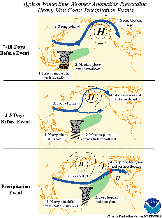
7-10 days before the event we notice strong blocking high pressure located in the gulf of alaska and intense PJ across the pacific extending into north america. Notice the position of the enhanced convection associated with the MJO is located just east of 120E.
by 3-5 days preceeding the event we take note of several changes...the moisture plume extends further northeast as a split flow begins to develop in the PAC jet which occurs as the block retrogrades out of the gulf of alaska and the tropical and extra tropical circulations phase with one another which causes the developing trough to draw in the sub-tropical moisture.
the precipitation event is self occurs as the deep tropical moisture plume becomes extended northward interacting with the trough off the west coast. the upper level jet them becomes directed at the pacific northwest. the low its self can become very strong and bring several days of heavy rain and mountain snows to the pacific northwest coast.
PAC northwest (western washington and oregon): 120E-130E
Central and northern california: 140E-160E
Southern and southwest california: 160E-170E
remember the further east the area of enhanced convection is located the further south the heaviest precipitation will occur. but at the same time the correlation between the MJO and heavy precipitation DECREASES the further south one goes along the west coast.
The figure below shows what would be the best set up for a heavy rainfall event in the PAC northwest:
7-10 days before the event we notice strong blocking high pressure located in the gulf of alaska and intense PJ across the pacific extending into north america. Notice the position of the enhanced convection associated with the MJO is located just east of 120E.
by 3-5 days preceeding the event we take note of several changes...the moisture plume extends further northeast as a split flow begins to develop in the PAC jet which occurs as the block retrogrades out of the gulf of alaska and the tropical and extra tropical circulations phase with one another which causes the developing trough to draw in the sub-tropical moisture.
the precipitation event is self occurs as the deep tropical moisture plume becomes extended northward interacting with the trough off the west coast. the upper level jet them becomes directed at the pacific northwest. the low its self can become very strong and bring several days of heavy rain and mountain snows to the pacific northwest coast.
0 likes
Who is online
Users browsing this forum: No registered users and 95 guests