Winter in the Deep South Arrives Tonight!!!

Winter Weather Discussion

Moderator: S2k Moderators

Forum rules

The posts in this forum are NOT official forecast and should not be used as such. They are just the opinion of the poster and may or may not be backed by sound meteorological data. They are NOT endorsed by any professional institution or STORM2K.

Help Support Storm2K
Message
Author
User avatar
FLguy
Professional-Met
Professional-Met
Posts: 799
Joined: Mon Dec 29, 2003 5:36 pm
Location: Daytona Beach FL
Contact:

#21 Postby FLguy » Sun Jan 04, 2004 11:40 pm

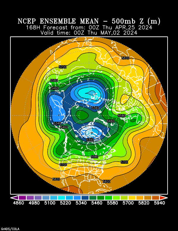
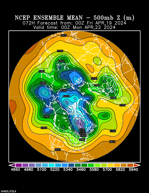
the ensembles are in decent agreement with the operational run on the retrogression of the pattern across the north pacific:

Image

notice by the 7th how the ensembles analyze the block across EXTREME western portions of siberia. by the 11th...the entire pattern across the north pacific has become re-organized with low pressure near the aleutian islands and the development of the PNA ridge.

Image

by 216hrs the GFS takes on the look of tonights EC with respect to the strong PNA ridge...deep EUS trough...sub-tropical trough east of HI wihyt plenty of energy coming through the STJ.
0 likes   

User avatar
FLguy
Professional-Met
Professional-Met
Posts: 799
Joined: Mon Dec 29, 2003 5:36 pm
Location: Daytona Beach FL
Contact:

#22 Postby FLguy » Sun Jan 04, 2004 11:42 pm

Stormsfury wrote:
FLguy wrote:
Stormsfury wrote:And technically speaking, I'm not surprised that the runs are coming in colder, ALhurricane has a good thread about the GFS MOS numbers coming down, due to the fact, that it mishandles the shallow nature of the arctic air.

SF


and because of that you will also notice the numbers from your local NWS offices come down even further over the next few days.


Yeah, and they're already quite bullish with temperatures in the mid-20's, and upper teens in the normally colder spots ... this could be an INCREDIBLE outbreak ... from record highs to record lows in the same week ...

And with the 0z GFS looking a little wetter on the QPF's on the first system, and the 00z GGEM showing the MECS/SECS potential on the Jan 12th-14th timeframe ... this continues to scream potential.

Time for winter to begin ...

SF


sounds alot to me like the entire winter of 1995-96
0 likes   

roarusdogus
Tropical Storm
Tropical Storm
Posts: 138
Joined: Tue Oct 07, 2003 8:04 pm

#23 Postby roarusdogus » Mon Jan 05, 2004 8:42 am

Jeb wrote:
Jeb wrote:High was 74 today......down to 48, but folks, remember, our normal high is 43 degrees........


Bring it!!!!!!

SnowBlitzJEB!!!!!!!!!!!!!!!!!!!!!!!!!!!! I'm Ready!!!!!!!!!!!!!!!!!!!!!!!!


No sarcasm intended here....................but the front we got today was no arctic front.

We had a high of 74 degrees which is about 31 degrees ABOVE normal.

We have cooled down to 48 so far. However, that only qualifies as a cool front, that's no arctic front. Our normal high is 43, and our normal low is 27 this time of year. Simple climo.

What we got today could be termed a cool front that cooled us down some twenty-eight degrees.........to levels still above normal for this time of year.

It's 48 degrees at 1030pm. If we extrapolate that to a high temperature, I'd say that with 48 degrees at 1030pm, we should have come down from a high of about 64, 65 degrees this afternoon. A high of 65 translates to late October/early November conditions.

So, behind this front we got today, we are basically well above normal, though admittedly cooler than we were earlier today.

Additionally, tomorrow we are progged to hit 62 degrees again for a high temperature. When I heard that I almost started to cry. I took a very sad jebwalk tonight.........it was about 50 degrees with a DP of 44 degrees, quite comfortable and I almost did not need my lightest paper-thin jacket.

This post is not meant to be sarcastic, and I am not denigrating anyone.

It was meant to be objective.

Just wanted to let everyone know what is actually going on here in northern VA tonight. It is in actuality a quite comfortable evening after frontal passage. It is certainly not cold, 48 degrees with a 7mph NE wind.

This is weather.com's forecast temps for Woodbridge VA:

Mon Jan 5 62/31 62 after a cold front in Jan is laughable. lol
Tue Jan 6 41/17 I'll take this, because of the 17 low.
Wed Jan 7 34/17 This is decent cold.
Thu Jan 8 35/12 This is decent cold.
Fri Jan 9 41/15 I'll take this, because of the 15 low.
Sat Jan 10 43/23 I'll take this, because of the 23 low.
Sun Jan 11 47/28 This is average but that 47 is a bit high for me.
Mon Jan 12 42/20 I can deal with 42; the 20 low is cool by me.
Tue Jan 13 36/17 I'll take this 36/17 range :)


In the past, (although I am well aware our climate is WARMING over time and it can't be helped, it is inevitable), I have noticed that arctic fronts bring us highs in the 20s, if not the teens!!!!!. Arctic fronts generally bring us highs in the 20s. Back in the 1980s, arctic fronts generally brought us highs in the low 20s for about 5 days to a week. Lows were in the teens and single digits above zero.

Now even if our recent highs had not been in the 60s and 70s, but had been in the 40s and 50s, an arctic front would be expected to bring us a few days of highs in the 20s or at least near 30. A period of cold in January in Woodbridge VA that is characterized by highs in the mid/upper 30s is NOT the result of Arctic Front cold advection. Highs in the mid/upper 30s are the result of a moderate cold front, NOT an arctic front. If this is so, what then of highs in the 40s? If a front brings highs in the 40s which are normal temperatures for Woodbridge VA in early January, then that cold advection must be from a normal, not arctic cold front.

Now we have had two days of highs in the 70s, and the day before that it hit the 60s. Those are departures of 30, 30 and 20 degrees above normal, respectively. The fact that this front that hit us today dropped us from 74 to 48 does in no way, shape or form mean that it is in fact an arctic front. It may have been a sharp cold front, but if that is what it was, after this sharp cold front hit us, in the wake of this sharp front, what we are left with is admittedly above-normal temperatures tonight. Tomorrow we will top out at 62 degrees. Some cold front lol :) This is an attempt at wry humor folks, not sarcasm. Sarcasm is not what I am attempting here lol.

I am just trying to report what is actually happening here in Woodbridge VA and I am trying to be humorous, not sarcastic.
I am in no way, trying or attempting to denigrate or make fun of all or any of the forecasters, amateur or pro in any way. I am however poking fun at this sharp cold front lol.
Perhaps the models will soon trend upwards to come into consensus with this weather which in fact IS happening here in Woodbridge VA.

One more thing: IF we do actually get this arctic front, I do hope we at least get to enjoy 3 to 5 days of highs in at least the upper 20s (though I had my heart set on low 20s) and lows in the teens (though I had my heart set on single digits and perhaps a low near zero.....)


I'll keep everyone updated on this mysterious cold front. LOL!!


JEB

You just aren't understanding whats going on, that's all. I'm almost ready to gurantee you that you will see highs in the 20s at some point in this upcoming pattern. the fact that you were in the 40s yesterday has nothing to do with global warming, you just don't understand what's going on.
0 likes   

User avatar
Amanzi
Category 5
Category 5
Posts: 4883
Age: 47
Joined: Wed Oct 09, 2002 10:12 pm
Location: Epsom,UK

#24 Postby Amanzi » Mon Jan 05, 2004 10:23 am

Ok this sux!!!

My highs for the rest of the week are in the upper 60's.. so Im guessing this airmass is not coming to pay me a visit... sorry but I dont know how to read model maps :( I just want some winter.. Ill take anything!
0 likes   

roarusdogus
Tropical Storm
Tropical Storm
Posts: 138
Joined: Tue Oct 07, 2003 8:04 pm

#25 Postby roarusdogus » Mon Jan 05, 2004 12:09 pm

Amanzi wrote:Ok this sux!!!

My highs for the rest of the week are in the upper 60's.. so Im guessing this airmass is not coming to pay me a visit... sorry but I dont know how to read model maps :( I just want some winter.. Ill take anything!


Right now, this isn't a classic east of the Rockies arctic blast. Notice Seattle is in the low 20s and is going to get a good snow and ZR event. If Seattle is in arctic air, it's almost guranteed Florida will not be. The flow across the country actually has a zonal look to it. However, this isn't your typical Pacific air you usually associate with a zonal flow. The flow in Canada is cross polar and that gets into the US even with a zonal look to it. This is why an area like Boston can have below normal temps the same time as Seattle. However, that does look to change down the road. It does look like a huge ridge is going to be going up on the west coast, Big Aleutian(sp?)low, polar vortex in eastern Canada and continuing cross polar flow means i think your turn is coming. I would be prepared because this air means business. With these weak west to east systems and possibly a larger system early next week, there could be a decent snowpack laid down across the country as a track as well. the bottomline Amanzi, I'd be prepared to shiver by around mid month or so if I were you.
0 likes   

roarusdogus
Tropical Storm
Tropical Storm
Posts: 138
Joined: Tue Oct 07, 2003 8:04 pm

#26 Postby roarusdogus » Mon Jan 05, 2004 12:11 pm

Amanzi wrote:I just want some winter.. Ill take anything!


This is definitely an oxymoron coming from someone is Florida. :wink:
0 likes   

User avatar
southerngale
Retired Staff
Retired Staff
Posts: 27418
Joined: Thu Oct 10, 2002 1:27 am
Location: Southeast Texas (Beaumont area)

#27 Postby southerngale » Mon Jan 05, 2004 12:48 pm

roarusdogus wrote:
Amanzi wrote:Ok this sux!!!

My highs for the rest of the week are in the upper 60's.. so Im guessing this airmass is not coming to pay me a visit... sorry but I dont know how to read model maps :( I just want some winter.. Ill take anything!


Right now, this isn't a classic east of the Rockies arctic blast. Notice Seattle is in the low 20s and is going to get a good snow and ZR event. If Seattle is in arctic air, it's almost guranteed Florida will not be. The flow across the country actually has a zonal look to it. However, this isn't your typical Pacific air you usually associate with a zonal flow. The flow in Canada is cross polar and that gets into the US even with a zonal look to it. This is why an area like Boston can have below normal temps the same time as Seattle. However, that does look to change down the road. It does look like a huge ridge is going to be going up on the west coast, Big Aleutian(sp?)low, polar vortex in eastern Canada and continuing cross polar flow means i think your turn is coming. I would be prepared because this air means business. With these weak west to east systems and possibly a larger system early next week, there could be a decent snowpack laid down across the country as a track as well. the bottomline Amanzi, I'd be prepared to shiver by around mid month or so if I were you.


Should this next one reach Southeast Texas? I'm sitting at 45° right now but I'd like to see it even colder down here. :)

Our normal highs are around 60° this time of year and we won't see 60° till at least Friday, if then. I'm not complaining, but I want snow temperature. :) It's been too long.
0 likes   
Please support Storm2k by making a donation today. It is greatly appreciated! Click here: Image

Image my Cowboys Image my RocketsImage my Astros

Johnny
Category 5
Category 5
Posts: 1428
Joined: Thu Jul 10, 2003 1:35 pm
Location: No Snow For You, Texas

#28 Postby Johnny » Mon Jan 05, 2004 1:30 pm

southerngale, I'm with you on this one. It's been a pretty good while since we have seen a good arctic front push through Southeast, Texas. When was the last time we stayed below freezing for a 36 to 48 hour period? It's sitting at 40 up in Conroe right now and it's 12:45. I think we will see some of this very cold air but we might have to wait a bit longer.
0 likes   

roarusdogus
Tropical Storm
Tropical Storm
Posts: 138
Joined: Tue Oct 07, 2003 8:04 pm

#29 Postby roarusdogus » Mon Jan 05, 2004 1:37 pm

Come on now guys. Temps of 15-20 degrees below average is significant cold. Yes, it can get colder but you have to get a perfect set up. Will that happen? It could the way things are looking but I'm more excited about Florida's prospects down the road. At least with so much cold air on our side of the pole, you at least stand a chance at getting some snow at some point. Remember Cape Canaveral last winter had ocean effect snow. Rare as ever. That was the first time since 1977. It must be due to global warming. lol :lol:
0 likes   

User avatar
Amanzi
Category 5
Category 5
Posts: 4883
Age: 47
Joined: Wed Oct 09, 2002 10:12 pm
Location: Epsom,UK

#30 Postby Amanzi » Mon Jan 05, 2004 1:55 pm

roarusdogus wrote:
Amanzi wrote:Ok this sux!!!

My highs for the rest of the week are in the upper 60's.. so Im guessing this airmass is not coming to pay me a visit... sorry but I dont know how to read model maps :( I just want some winter.. Ill take anything!


Right now, this isn't a classic east of the Rockies arctic blast. Notice Seattle is in the low 20s and is going to get a good snow and ZR event. If Seattle is in arctic air, it's almost guranteed Florida will not be. The flow across the country actually has a zonal look to it. However, this isn't your typical Pacific air you usually associate with a zonal flow. The flow in Canada is cross polar and that gets into the US even with a zonal look to it. This is why an area like Boston can have below normal temps the same time as Seattle. However, that does look to change down the road. It does look like a huge ridge is going to be going up on the west coast, Big Aleutian(sp?)low, polar vortex in eastern Canada and continuing cross polar flow means i think your turn is coming. I would be prepared because this air means business. With these weak west to east systems and possibly a larger system early next week, there could be a decent snowpack laid down across the country as a track as well. the bottomline Amanzi, I'd be prepared to shiver by around mid month or so if I were you.


That is sweet music to my ears!!! I wanna shiver a lil bit for a change ;)
Thanks for the discusion, I really appreciate it :)
0 likes   

wrkh99

#31 Postby wrkh99 » Mon Jan 05, 2004 1:57 pm

What is this snow stuff you people keep talking about ?
0 likes   

User avatar
FLguy
Professional-Met
Professional-Met
Posts: 799
Joined: Mon Dec 29, 2003 5:36 pm
Location: Daytona Beach FL
Contact:

#32 Postby FLguy » Mon Jan 05, 2004 10:19 pm

and furthermore...as i was discusing with the relationship between the WPO phase and retrograding block...we can see tha tthe daily WPO indicies outline my ideas perfectly:

Image

notice how the WPO values have been averaging between 0 and about -2 since about JAN 1. and as long as the block remains in place across extreme eastern siberia...the WPO should remain solidly negative. this is one of the mechanisims responsible for the cold we will be experiencing.
Last edited by FLguy on Mon Jan 05, 2004 10:26 pm, edited 1 time in total.
0 likes   

User avatar
FLguy
Professional-Met
Professional-Met
Posts: 799
Joined: Mon Dec 29, 2003 5:36 pm
Location: Daytona Beach FL
Contact:

#33 Postby FLguy » Mon Jan 05, 2004 10:21 pm

when the block is further to the east (in the gulf of AK) it is then refered to as a negative EPO or Eastern Pacific Oscillation.
0 likes   

User avatar
vbhoutex
Storm2k Executive
Storm2k Executive
Posts: 29112
Age: 73
Joined: Wed Oct 09, 2002 11:31 pm
Location: Cypress, TX
Contact:

#34 Postby vbhoutex » Mon Jan 05, 2004 11:33 pm

Ok, I have taken my first good look at the models tonight. I by no means can interpret them like the pros and SF and KOW do, but I have a pretty decent idea of what I am looking at.

As far as my idea of the deep south(ie coastal and/or SE TX)is concerned, I do not see any unusual cold making its way to SE TX anytime soon. When I say unusual cold for us I mean into the low 20's. About the coolest I see is maybe a 32º on Weds. morning. Precip. appears to be almost non-existant over the next week at a minimum if not for the next two. Yes I do know not to trust the models past 7 days max. Our friends to the East appear to be getting a nice shot from all of this, all the way to the coast in N. FL. (I knew I should have stayed in Tallahassee! :roll: )

If I am off on this please explain what you see or I may be missing that makes this incorrect.
0 likes   
Skywarn, C.E.R.T.
Please click below to donate to STORM2K to help with the expenses of keeping the site going:
Image

User avatar
Stormsfury
Category 5
Category 5
Posts: 10549
Age: 53
Joined: Wed Feb 05, 2003 6:27 pm
Location: Summerville, SC

#35 Postby Stormsfury » Tue Jan 06, 2004 12:31 am

ECMWF 8-10 day 3 day average ... This looks DAMN COLD! and in fact, even COLDER than this current blast SOLELY based on the average 500mb height outputs tonight ...

ALSO, I'm noticing on the averages an undercutting s/w which COULD be heading east towards the confluence zone and WITH BRUTAL ARCTIC AIR in place could be a BONAFIDE Deep South Winter weather potential ... but again, JUST PURE speculation, and too far out to worry about at this time.

Right now in the immediate short-term ... the EC is trending a little stronger with the Thurs/Fri GOM s/w ... and decent RH's at the 850mb, and 700mb level, but will it be able to penetrate SFC DP's that are progged to be in the single digits (even in the Southeast)? No doubt in my mind that the temperatures will trend a little colder, but just how much moisture ATT remains in question (reaching the ground).

SF
0 likes   

User avatar
FLguy
Professional-Met
Professional-Met
Posts: 799
Joined: Mon Dec 29, 2003 5:36 pm
Location: Daytona Beach FL
Contact:

#36 Postby FLguy » Tue Jan 06, 2004 1:09 am

Stormsfury wrote:ECMWF 8-10 day 3 day average ... This looks DAMN COLD! and in fact, even COLDER than this current blast SOLELY based on the average 500mb height outputs tonight ...

ALSO, I'm noticing on the averages an undercutting s/w which COULD be heading east towards the confluence zone and WITH BRUTAL ARCTIC AIR in place could be a BONAFIDE Deep South Winter weather potential ... but again, JUST PURE speculation, and too far out to worry about at this time.

Right now in the immediate short-term ... the EC is trending a little stronger with the Thurs/Fri GOM s/w ... and decent RH's at the 850mb, and 700mb level, but will it be able to penetrate SFC DP's that are progged to be in the single digits (even in the Southeast)? No doubt in my mind that the temperatures will trend a little colder, but just how much moisture ATT remains in question (reaching the ground).

SF


we will have to take the JAN 12-14 POSSIBLE SECS/MECS one day at a time...however the day 8-10 EC is IMO VERY impressive with MAJOR complications in the long-term pattern

i want to draw the folks attention to first of all the almost complete reversal of the pattern in the PAC as low pressure takes up position near the aleutians which pumps the PNA ridge (Strongly +PNA pattern) and argues for a DEEP EUS trough as the PV takes up position over hudsons bay in the day 8-10 timeframe. the trough in SCAND would also imply a strongly amplified (deep) EUS trough.

remember also critical teleconnections...a +PNA and -NAO usually translates to the synoptic set-up for a VERY cold pattern across the EUS.

next up is the sub-tropical trough east of HI...and the split flow along the west coast of north america...which would imply that quite a bit of STJ energy (partly the effect of the strong eastward moving kelvin wave discussed yesterday as moisture from it gets drawn into pattern) is going to undercut the PNA ridge and eventually encounter the cold air across the central and EUS setting the stage for plenty of problems as we get toward the weekend of the 17th.

another MAJOR problem with the JAN 12-14 SECS/MECS is it would break the SECS/weekend rule for the big cities. (the 12-14th is a MON to a WED..though this does not always apply to the southern mid-atlantic and new england or inland locations...so there is still potential there in this respect).

nonetheless it is a very cold pattern for portions of the lakes...OV and EUS. with the POTENTIAL to stir up some BIG problems.
0 likes   

User avatar
vbhoutex
Storm2k Executive
Storm2k Executive
Posts: 29112
Age: 73
Joined: Wed Oct 09, 2002 11:31 pm
Location: Cypress, TX
Contact:

#37 Postby vbhoutex » Tue Jan 06, 2004 7:47 am

vbhoutex wrote:Ok, I have taken my first good look at the models tonight. I by no means can interpret them like the pros and SF and KOW do, but I have a pretty decent idea of what I am looking at.

As far as my idea of the deep south(ie coastal and/or SE TX)is concerned, I do not see any unusual cold making its way to SE TX anytime soon. When I say unusual cold for us I mean into the low 20's. About the coolest I see is maybe a 32º on Weds. morning. Precip. appears to be almost non-existant over the next week at a minimum if not for the next two. Yes I do know not to trust the models past 7 days max. Our friends to the East appear to be getting a nice shot from all of this, all the way to the coast in N. FL. (I knew I should have stayed in Tallahassee! :roll: )

If I am off on this please explain what you see or I may be missing that makes this incorrect.


I take the no comments to mean I am close to right??? We are currently at 34º here with a high of 41º expected(now that is cold for here for a high).

I am starting to think that I may be off somewhat with my comments since the NW is getting pounded right now. How much of an impact will that have on us here in the next few days(if any) or will it go the "northtern" route?

Meanwhile I see the lake effect is kicking in big time again today. Looks like some of our frineds in NY, PA, MI, OH are gonna see the flakes today!! Ah well, at least I don't have to shovel it!!! And, BTW, if you are ever in Houston when we have a winter precip event-STAY OFF THE ROADS!!!!-no one here knows how to drive in it and it is literally a FREE FOR ALL on the roads.
0 likes   
Skywarn, C.E.R.T.
Please click below to donate to STORM2K to help with the expenses of keeping the site going:
Image

Suzi Q

#38 Postby Suzi Q » Tue Jan 06, 2004 8:36 am

I don't see anything popping for us either David but I am surprised at how the local forecasts keeping dropping our high temps. Remember back on Friday, our high yesterday was suppose to be 58 and there was no mention of this high occurring well before sunrise. Yesterday morning they said today's high would be in the upper forties and today they say "good luck" on getting out of the low forties, and it's what 34 now? Coupled with a freeze tonight, which was never even mentioned until this morning. And I even heard one forecaster mention the "sleet" word last night! As far as I know I NEVER saw a model showing us getting this lovely weather but if someone can provide a link to one, I'd be happy to say "AHA. The Models were right on target". Otherwise, I'll just wait and see how each one pans out, as opposed to losing all hope on us EVER seeing any snow here! Stranger things have happened, right?
0 likes   

User avatar
vbhoutex
Storm2k Executive
Storm2k Executive
Posts: 29112
Age: 73
Joined: Wed Oct 09, 2002 11:31 pm
Location: Cypress, TX
Contact:

#39 Postby vbhoutex » Tue Jan 06, 2004 10:37 am

eb4480 wrote:I don't see anything popping for us either David but I am surprised at how the local forecasts keeping dropping our high temps. Remember back on Friday, our high yesterday was suppose to be 58 and there was no mention of this high occurring well before sunrise. Yesterday morning they said today's high would be in the upper forties and today they say "good luck" on getting out of the low forties, and it's what 34 now? Coupled with a freeze tonight, which was never even mentioned until this morning. And I even heard one forecaster mention the "sleet" word last night! As far as I know I NEVER saw a model showing us getting this lovely weather but if someone can provide a link to one, I'd be happy to say "AHA. The Models were right on target". Otherwise, I'll just wait and see how each one pans out, as opposed to losing all hope on us EVER seeing any snow here! Stranger things have happened, right?


Dfinitely is not what any one local was saying, even in the NWS discussions yesterday that I looked at!! Maybe I am remembering them wrong, but this is not what was being broadcast even yesterday!! LET'S HOLD OUT THAT HOPE!!!
0 likes   
Skywarn, C.E.R.T.
Please click below to donate to STORM2K to help with the expenses of keeping the site going:
Image

Johnny
Category 5
Category 5
Posts: 1428
Joined: Thu Jul 10, 2003 1:35 pm
Location: No Snow For You, Texas

#40 Postby Johnny » Tue Jan 06, 2004 11:45 am

I started a thread about this. This past Saturday and even Sunday morning, not one local T.V. met mentioned that we could get this kind of cold. Not one. They said that the front that will be coming through Sunday night would bring us down into the lower 40's for lows and mid to upper 50's for highs through Wednesday. I'm not downing the T.V. mets but I'll tell you one thing, they were waaaaaaaaay off and so was the NWS! I'm sitting at 31 degrees up here in Conroe and we will not get out of the 30's today. I don't think anyone here or on any other boards forecasted this kind of cold penetrating all they into the deep south. As far as frozen precip, I don't see it with this one but yes, stranger things can happen. More arctic air on the way come next week I think???
0 likes   


Return to “Winter Weather”

Who is online

Users browsing this forum: Google Adsense [Bot] and 1 guest