 The posts in this forum are NOT official forecast and should not be used as such. They are just the opinion of the poster and may or may not be backed by sound meteorological data. They are NOT endorsed by any professional institution or


Admittedly ---- the southern end of my 5-10” area for the clipper a few days ago BUSTED BADLY south of the PA turnpike (I-76). North of there however I was fairly pleased with the forecast. Many locations out on long island received accumulations within the range I outlined the day before.
Not only that…it also appears that my phasing idea fore this weekend IS NOT going to verify. Why? Well for one … has anybody seen that ridiculously strong ocean low. This morning pressures were down to 948mb ---- making the system about the strength of a CATEGORY 4 HURRICANE. On another front…the system is so obscenely strong that it carried most of the coldest air away with it further east. Which is the reason why many areas in the I-95 corridor from PHL to BWI and DCA didn’t get as low as they cold have gotten IF the system were weaker. Remember folks low pressure systems are like enormous suction cups. They like to pull air inward toward them and the stronger the system is the better able it will be to do so. This is one hell of an ocean low and one of the strongest I have seen in some time. The great Appalachian storm was an example of one in which the system its self was so strong that the warm sector actually was located on the northern side of the system and all the snow fell on the southern side with cold air advection coming in from a south and southeast direction. A VERY amazing scenario. Now if only we could take that HUGE ocean low and park it off the Delmarva about 20mb weaker (in the 968-970mb range)…then we would be talking lol.
In any case the main reason or the lack of phasing is the northern branch…which thanks to the strong and displaced PV has NOT allowed for a whole lot in the way of digging. Now if the PV was located further north and weaker it would allow the jet to relax and system would then be allowed to dig more. The problem also has been the fast train of s/w energy coming through the ridge (either up and over the PNA ridge or they undercut it which takes the ridge and forces it eastward…before re-building and then the cycle repeats its self). In other words the PJ is TOO STRONG that as soon as one prospective piece of s/w energy comes through the flow its kicked along by another and then the same thing happens to that. Phasing DOES occur but offshore. So we would definitely need to see the PJ version of Amtrak get derailed before we can expect to see any kind of phasing with the STJ.
What would have been needed for phasing to occur with the STJ feature this weekend is the trough splitting in the PJ with the first piece of s/w energy weaker and the second stronger and the STJ energy its self would have had to come out AHEAD of the PJ energy in order for phasing to occur. IF the PJ energy comes out BEFORE the STJ energy the STJ s/w will be crushed or the STJ energy is left behind. In the case that the STJ s/w is kicked out ahead of the digging PJ energy phasing would occur and a major storm would ensue. The strong PV of recent of course didn’t help matters any since the jet tightens underneath it and most s/w energy which comes through the flow is 1) not allowed to dig … 2) if it is too close to the PV the jet will shear it apart.
The clipper was an example of a strong s/w which was just far enough south that it avoided the jet associated with the PV and was actually allowed to sustain its self VERY well. But of course it was much stronger than what is normal for a system.
Now don’t get me wrong we have SOME….AND THATS THE KEY WORD HERE…SOME of the right ingredients for phasing
1) The recently re-energized STJ sending plenty of energy out.
2) Tanked NAO (which is they way it has been much of the winter thus far)
3) The strong PV now becoming relocated in a more climatologically normal position (and weaker) as compared to suppressed off to the southeast over SE Canada…Newfoundland or northern new England. Which are ridiculous positions for the PV at any time of year in the first place.
When the PV is located in these positions it forces whatever s/w energy coming through the flow to be shunted out to sea quickly. Thus no amplification of the s/w can take place and the system does not close off in the mid and upper levels.
The system this weekend will have a nice swath of snow with it up into PA / NJ / SE NY / NYC and LI once again (probably 1-3” on the average) as the handoff takes place but not much more than that. Across the mid-Atlantic (south of the PA/MD border) too much warm air may be preset to allow for an all snow situation so even with higher QPFs not much snow will fall. there will be more in the way of IP / FRZRA / RA instead.
Its impossible to isolate the exact behavior of one system which would allow or phasing to take place since there are many different scenarios which would lead to such events but if we look at the overall pattern there is only one CRITICAL feature missing and that is a sustainable PNA ridge to cutoff or temporarily hold off the PJ express so that one PJ s/w coming through the flow doesn’t have that much energy on its heels ---- kicking it out too quickly. Which if there isn’t anything following in too close behind it will be allowed to dig more and POSSIBLY phase.
Now one of the driving features behind the very strong PJ and overall La Nina look to the pattern in spite of the SSTA in the equatorial PAC has been the negative (east) QBO. The QBO switched back to the east phase in DEC 02...peaked in AUG 03 and is currently at
-11.38 for the month of DEC 03. This is indicative of a QBO which is east and increasing west. This net change in the QBO index was +6.48 between NOV and DEC of 03 as compared to a net change of only +2.48 between OCT and NOV of 03. So yes the QBO is RAPIDLY increasing west. FEB should be a transitional month for the QBO (VERY weak east to start then reversal to west by the end of the month) but the point here is that the QBO will largely be neutral or near neutral in FEB. Then solidly positive (west) in MAR. What would this mean? well for one the strong dominating PJ would tend to slow down and relax (as the west phase of the QBO is correlated to a weaker PJ). 2) better potential for phasing…and 3) a better likelihood for a major east coast snow event or more than one.
Weak QBO values between +/-10.00 are usually correlated best with an INCREASED likelihood for a major east coast snow event. That said…the signal its self is weak so as we saw in December…IF other occurrences favor a major east coast snow event then it will happen … if not then the QBO signal wont mean poop. Here is a link to the QBO data from the CDC:
http://www.cdc.noaa.gov/correlation/qbo.data
Now what about our water temperature profile in the north PAC ---- well we still have the cold pool but as we notice it has begun shifting west and slight warming is now beginning to show up along the west coast of north America:
https://www.fnmoc.navy.mil/products/OTI ... nomaly.gif
This argues for low pressure near the Aleutians and a downstream PNA ridge. Now of course this is no where near along the lines of what we saw in 1993-94 and last winter but it is more heavily weighted toward a +PNA. The warm water east of Japan and arm pool near 180 in the equatorial PAC support this trend as well.
Heres the latest AGCM run from JAN 6:
200 hPa heights:

SFC temps:

Notice the negative anomaly sitting to the southwest of the Aleutians with the strong blocking over the top and to the east of it. This would imply a +PNA in the means…however the signal is much more variable than it was in the 1993-94 and 2002-03 winters so the +PNA will NOT dominate the pattern. However with the QBO going west theres LESS likelihood that the trough will once again get pulled back into the western US for any appreciable amount of time.
The warm water out near 180 is also supportive of a +PNA and a very cold pattern for the EUS.
Now what to do about the developing El Nino. A series of Kelvin waves moved eastward across the tropical PAC which contributed to some warming. However over the past month the warmest SSTA have been located close to and just west of 180 and on the order of +0.5 and +1.5C:
http://www.cdc.noaa.gov/map/images/sst/ ... .month.gif
The other three NINO regions (1+2...3.0...and 3.4) have been running near normal. Heres a text representation of SSTA totals and anomalies since the second week of DEC:
10 DEC 2003 22.9 .3 25.5 .4 27.0 .5 29.1 .9
17 DEC 2003 23.0 .1 25.4 .3 26.8 .4 29.0 .7
24 DEC 2003 23.0 -.2 25.6 .4 26.8 .3 28.9 .6
31 DEC 2003 23.8 .2 25.7 .4 26.7 .2 28.7 .5
07 JAN 2004 24.2 .2 25.7 .3 26.6 .1 28.7 .5
And on a monthly time scale (text format):
2003 10 20.99 .08 25.33 .43 29.22 .81 27.19 .60
2003 11 21.92 .27 25.40 .45 29.31 .95 27.05 .53
2003 12 22.99 .15 25.56 .47 29.02 .75 26.89 .42
Graphical representation:

SSTA have decreased substantially since OCT in the Equatorial PAC but still as of now remain ABOVE normal. In DEC 03 the Nino 1+2 region was running +0.15C…Nino 3.0 was around +0.47 the Nino 3.4 region was about +0.42 and the 4.0 region close to +0.75. Now that said the Nino 3.4 values WOULD be supportive of a major east coast snowstorm development. And true to form ---- we saw it happen. And that was with a strong east QBO.
ftp://ftpprd.ncep.noaa.gov/pub/cpc/wd52 ... /wksst.for
ftp://ftpprd.ncep.noaa.gov/pub/cpc/wd52 ... oi.indices
The NCEP model continues to indicate the development of El Nino conditions but due to the concurrent long term PDO cold cycle…and inconsistencies in the SOI and frequent fluctuations in SSTA across the tropical PAC. Heres the latest run of the NCEP ENSO model from this past Tuesday:
Monthly SSTA forecast:

Three month mean:

Notice how it has backed off slightly on the warming from the past several runs. Even with that said IF a weak to moderate El Nino does develop it WILL NOT be located close to the south America coast. this type of “classic” El Nino is NOT favored in the long term PDO cold cycle. It would be centered in the central or western equatorial PAC (much in conjunction with where the warmest SSTA been for the past 6 months).
I DO think a weak El Nino will develop in the next 4-8 weeks but it will not be a classic one. Something more consistent with what was seen last winter is a better bet as far as placement of the warm pool is concerned however it should not be as strong.
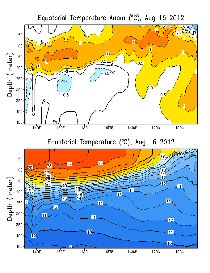
Sub-surface ocean temps and anomalies have not changed much in the past few weeks. Notice in the figure below the best warming is located across the western equatorial PAC which is normal (climatologically speaking and for ENSO neutral conditions) as far as placement is concerned however temps are running above normal and the 20C isotherm depth is between 150 and 200 meters west of 180.
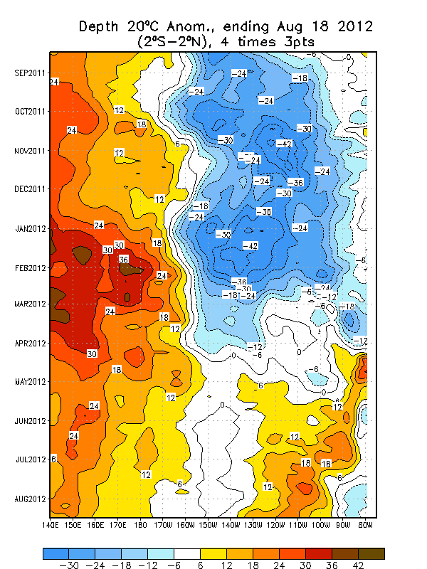
Time-longitude section of the anomalous equatorial depth of the 20C since last FEB:
With the QBO switching to west and the eventual evolution toward WEAK EL NINO conditions the second half of the winter is looking VERY FUN for the Midwest and northeast. The QBO signal…equatorial PAC SSTA in the NINO 3.4 region do favor one if not more major east coast snow events. And to answer a question in another thread…The first of which may come in the second week of FEB with another closer to the end of the month and then a final event to close out the winter in early march.
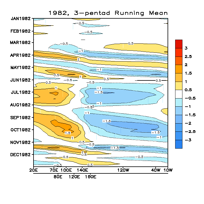
Meanwhile with the MJO related convection east of 180 I see no reason why the STJ would relax (other than the reversal of the SOI back to positive). Once things switch around and the enhanced convection sets up around 120E we should see the PAC jet firehouse get cranking again and the STJ shut off. Normally in other winds when we see an unrelenting STJ (like 1982/83) the MJO is relatively inactive (which is also normal for strong El Nino years):
1982:
1983:
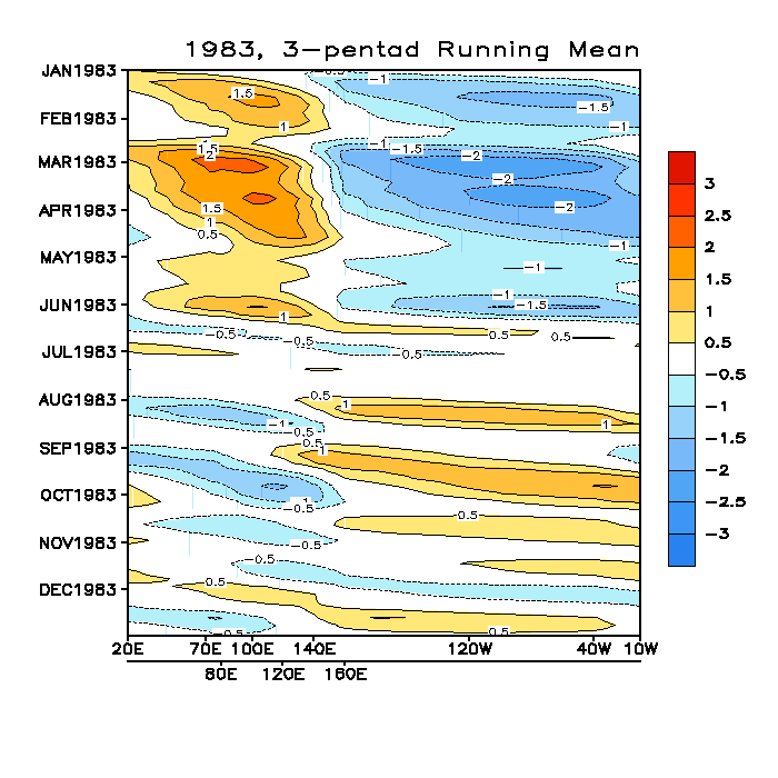
Notice that as the strong El Nino took shape the result was the MJO becoming relatively inactive however the enhanced convection remained east of 180 which supported the unrelenting STJ.
In summary I expect that the eastern 2/3 of the nation east of the Rockies will continue to see normal to below normal tempos through much of the rest of the winter with an INCREASING probability of something BIG snow wise in the next few weeks given the state of in the factors discussed above.


