 The posts in this forum are NOT official forecast and should not be used as such. They are just the opinion of the poster and may or may not be backed by sound meteorological data. They are NOT endorsed by any professional institution or


This is sort of a follow-up to the article entitled “THE SECOND HALF OF THE 03/04 WINTER WHAT DOES IT HOLD” which can be found at:
http://www.storm2k.org/phpbb2/viewtopic ... highlight=
First of all however a review of a few critical teleconnections:
The PNA:
Positive PNA pattern ---- Ridge in the western part of North America…trough in the eastern part of the country. Low pressure located near the Aleutian Islands pumps the downstream ridge across western North America which sends the trough into the eastern part of the country as the PV becomes established across eastern Canada. This is a cold pattern for the eastern 2/3 of the US. An Active STJ undercutting the ridge with a split in the flow across the eastern PAC is a SNOWY pattern for the southern plains…mid-Atlantic and in some cases northeastern parts of the country.

A persistently +PNA pattern is most common in El Nino/west QBO winters with warm water surrounding the west coast of North America and the cold pool located further back to the west. The two best and most recent examples of this were seen last winter and during the winter of 1993-94.
OCT 1993:

OCT 2002:

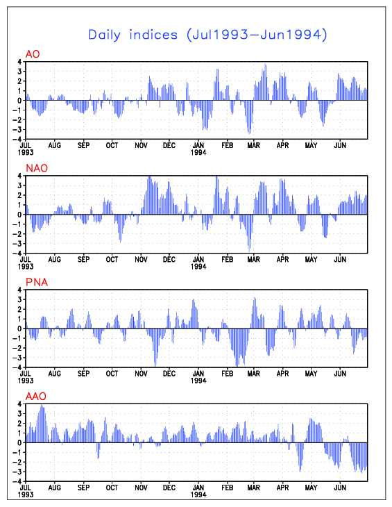
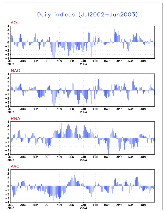
It should also be noted that the 1993-94 and 2002-03 SSTA configurations were the extremes of that particular SSTA configuration needed for a +PNA. Here are the daily PNA indices during both the 1993-94 and 2002-03 winters. Notice how the north PAC SSTA configuration corresponds to the observed phase of the PNA:
Daily indices 1993-94:
Daily indices 2002-03:
Negative PNA (RNA) pattern ---- the reverse of the PNA positive phase. Trough in the western part of the country and ridge off the southeast coast of the US low pressure near the Aleutians is very weak or replaced by a ridge which directs the trough into the western part of the country. This is a warm pattern for the eastern 2/3 of the country and cold pattern for the western half of the US however can be enhanced or mitigated by the NAO phase.
Storm track is normally from the southern plains to the lakes and New England. Precipitation is below normal across the southeastern part of the country. Normally the –PNA (RNA) pattern is most common in La Nina/east QBO winters.
This is most common when cold water is located in the Gulf of Alaska with NO warm water surrounding the west coast of North America. The warm pool is further back to the west in the same position as where the cold pool is located during a winter where the PNA positive phase dominates. The best example of this is the winter of 2001-02.
NOV 2001:

2001-02 daily indices:
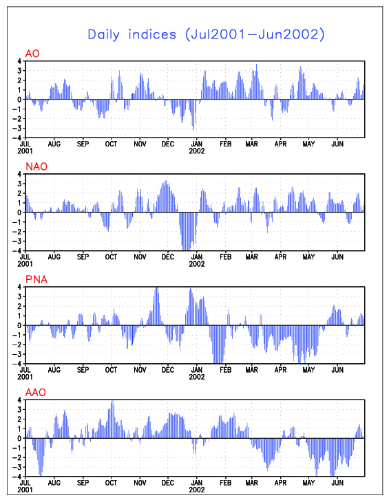
Notice there were ONLY 2 times during the entire winter of 2001-02 that the PNA was strongly positive. A short period in NOV and another in late DEC and JAN. Otherwise the PNA spent most of the winter in the tank.
The NAO:
Positive NAO ---- strong Icelandic low. A Ridge is found off the southeast coast of the United States and in Western Europe near Spain. Storm track is from the southern plains to the lakes and New England. Most of the big snows fall across the Midwest and great lakes while the Northeast and mid-Atlantic see mainly rain events. The Southeast is WARM AND DRY. Inland runners are most common. A positive NAO and Negative PNA pattern typically favors very warm conditions across most of the eastern 2/3 of the US.
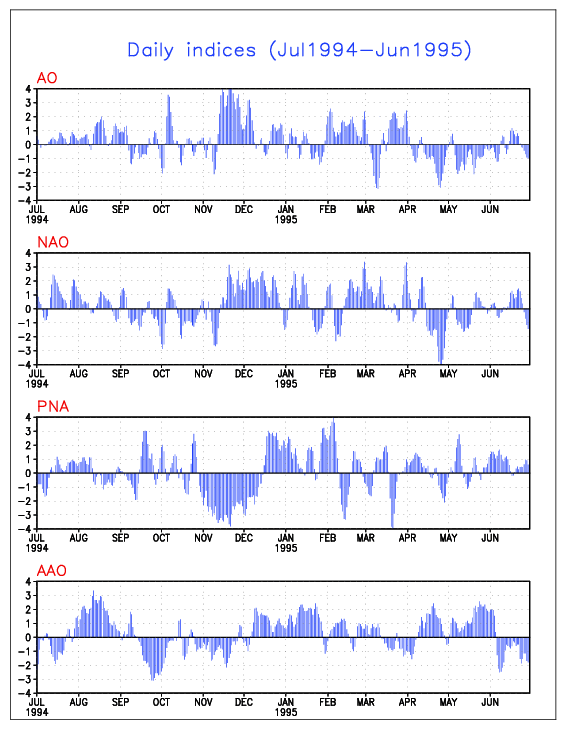
A weak ATC with a cold north Atlantic and equatorial Atlantic normally favors a positive NAO. However even with that said the NAO favored phase on a seasonal scale can be dictated by solar activity and northern hemispheric snow cover. The best example ---- the El Nino winter of 1994-95:
JAN 1995 SSTA:

1994-95 daily indices:
Negative NAO ---- Weak Icelandic low…blocking is noted across the north Atlantic in one of three positions:
1) Classic Greenland block. Main above normal height anomaly is located over Greenland.
2) Ireland/Britain. The above normal height center is located as far back is Ireland and Britain which still qualifies as a –NAO.
3) Baffin Island/Davis strait/Quebec. Main blocking center is located between the Davis strait…BI and Northeast Quebec. This is an EXTREME position for a Negative NAO and is typically correlated with a suppressed storm track.
Storm track is either from the Gulf of Mexico - up the east coast (classic Miller type A SECS/MECS track) or is suppressed off to the south with systems exiting off the mid Atlantic coast…NOT allowed to turn up either because the PV is strong and displaced very far to the southeast near Newfoundland or northern new England. If a 50/50 (Newfoundland) low is present (which is the name given to a low pressure center which is located near 50N latitude and 50W longitude) in the northwest Atlantic…it can enhance the strength of a –NAO or force the NAO to negative if it is neutral as the 50/50 low causes the shortening of the wavelengths in the PJ across the north Atlantic forcing the NAO negative or enhancing the strength of the blocking.
Normally a synoptic set-up characterized by a +PNA…blocking across Greenland a classic 50/50 low with the PV located in a climatologically normal position (IE not too displaced that it suppresses the flow) is the correct set-up for a major east coast snowstorm from the mid-Atlantic to the northeast.
Normally a –NAO is favored in winters with a strong ATC (more even distribution of heat and energy between the tropics and the poles with less thermal contrast between the pole and the equator) warm water across the north Atlantic and tropical Atlantic with a cold wedge in-between. The best example of this was seen during the 2002-03 winter:
JAN 2003 SSTA:

2002-03 daily indices:
The same thing goes for the AO positive and Negative phases.
The favored phase of the NAO on a seasonal scale can make a BIG …BIG difference in what type of winter the central and eastern US experiences in El Nino winters.
A Positive NAO in an El Nino winter can result in a very warm and wet pattern for the eastern part of the country whereas a Negative NAO during an El Nino winter can result in a VERY COLD AND SNOWY winter in the eastern part of the country. Usually this applies to weak and moderate El Nino winters. In a strong El Nino winter like 1972-73…1982-83 or 1997-98 the signal is so strong that it overwhelms the pattern and other features such as the NAO / AO / or other potential mitigating factors are simply drowned out.
The same thing goes for the influence of the NAO in a La Nina winter. La Nina winters with a positive NAO tend to be warm and dry winters in the southeast US and very cold across the western part of the country. On the other hand a La Nina / -NAO winter can be VERY exciting across the eastern part of the country. Best example of that…1995-96.
The QBO:
West (+) QBO ---- Anomalous westerly zonal winds at high levels (30-50 hPa) over the equator … known as the QBO positive phase. This has an enhancing effect on TC activity in the Atlantic and normally correlates to a weaker PJ in winter.
East (-) QBO ---- anomalous easterly zonal winds at 30-50 hPa over the equator which is known as the QBO negative phase. Typically a –QBO has a mitigating effect on Atlantic TC activity and correlates to a strong/dominating PJ in winter.
The combination between the ENSO and QBO can tell us a good deal about how the atmosphere will behave in winter.
For example a La Nina – east QBO winter tends to favor blocking and a –NAO which can lead to a cold pattern for the eastern part of the country. The same goes for an El Nino – west QBO winter. Normally in La Nina east winters the PJ is very strong and dominating with little STJ input. A variable PAC jet is usually observed (courtesy of an active MJO) and very wet pattern for the PAC northwest is common. What becomes of that PAC energy is determined by the NAO phase.
This is an ENSO neutral / East QBO winter following an El Nino winter. Normally an ENSO neutral winter following an El Nino winter tends to behave like the El Nino before it. We have seen SOME evidence of that. On the other hand last winter the QBO was near neutral (switching from west to east) this year it has been strongly east and is now beginning to decline as it turns west. The strong –QBO has contributed to the La Nina-like dominating PJ and variable PAC patterns. If this was an ENSO neutral / west QBO winter the PJ would have been LESS DOMINANT and we would have seen MORE STJ input which we are beginning to see now --- but have not up to this point. (Most likely the result of the QBO weakening considerably). We can also expect to see the strong PJ become LESS dominant over the next few weeks.
**IF** El Nino conditions begin to develop in the next few weeks (sooner rather than later preferably) as the QBO turns positive we may be able to expect to see a more active STJ and an increased threat for major winter storms across the eastern part of the country. The weaker PJ and enhanced STJ may lead to a better potential for phasing over the next few weeks.
QBO indices:
http://www.cdc.noaa.gov/Correlation/qbo.data
The SOI:
Positive SOI ---- stronger than average trade winds across the tropical pacific associated with La Nina (ENSO cold phase) conditions. Pressures are above normal at Tahiti and below normal at Darwin Australia. Normally a +SOI corresponds to decreased STJ activity.
Negative SOI ---- weaker than average trade winds across the tropical PAC which corresponds to El Nino (warm phase ENSO) conditions. Pressures are below normal at Tahiti and above normal at Darwin Australia. Normally STJ activity is enhanced during these periods.
MJO activity normally agrees well with the changes in SLP and SSTA anomalies in the tropical Pacific. Higher pressures across the western tropical PAC which correspond to a –SOI usually also tend to correlate well to suppressed convection near 120E and a thus a weaker PAC jet. The MJO related enhanced convection is located further east which ties into the enhanced STJ. The reverse is the case in La Nina winters where the MJO is more active relating to a +SOI (lower pressures near Darwin) which corresponds to enhanced convection near 120E and decreased convection across the eastern tropical PAC. Ultimately leading to a LESS active STJ and more variable PAC patterns.
Normally MJO activity is maximized in ENSO neutral and La Nina winters which leads to more variability in the PAC jet as we have seen most of this winter while the strong –QBO has lead to an enhanced PJ and more La Nina like pattern overall.
If we should see the development of El Nino conditions in the next few weeks we might expect to see a more persistently negative SOI and less in the way of MJO activity (common in El Nino years) leading to more STJ activity which until just recently has been lacking. The reversal of the QBO would argue to a weakening of the PJ and somewhat more El Nino like pattern.
The weakening QBO --- combined with the near to slightly warmer than normal SSTA in the equatorial PAC along with slightly negative SOI usually SCREAMS the potential for major east coast snow events.
Below are 500mb heights in FEB-MAR periods with a weak El Nino and west QBO:
FEB-MAR 1978:
FEB-MAR 1988:
FEB-MAR 1991:
FEB-MAR 1993:


