Look Familiar? UKMET advertising ANOTHER CAD event-Southeast

Winter Weather Discussion

Moderator: S2k Moderators

Forum rules

The posts in this forum are NOT official forecast and should not be used as such. They are just the opinion of the poster and may or may not be backed by sound meteorological data. They are NOT endorsed by any professional institution or STORM2K.

Help Support Storm2K
Message
Author
User avatar
Stormsfury
Category 5
Category 5
Posts: 10549
Age: 53
Joined: Wed Feb 05, 2003 6:27 pm
Location: Summerville, SC

Look Familiar? UKMET advertising ANOTHER CAD event-Southeast

#1 Postby Stormsfury » Wed Jan 28, 2004 2:40 pm

Sunday/Monday Next week ...

1027 mb high again centered over the Mid-Atlantic (extension from a 1032 mb high on Monday at 12z with the wedge draining as far south as South GA ... basically speaking, it sends the primary low up towards the OV, and secondary development in PRIME location for a Deep SE winter weather event ... Stay tuned ...

Image
0 likes   

Anonymous

#2 Postby Anonymous » Wed Jan 28, 2004 2:49 pm

12z nogaps has a pretty good coastal low at Hatterras

http://met.psu.edu/trop-cgi/nogapstc2.c ... =Animation

ukmet looks like it takes primary to NW PA and develops a secondary---will be interesting to see how this trends

gfs spits out alot of qpf for NVA,VA and the lower M/A but shows no wedge and as usual its appears to warm.
0 likes   

Anonymous

#3 Postby Anonymous » Wed Jan 28, 2004 2:49 pm

i also heard from a few mets from other weather sites that there could be another good snow for NJ for that simular time frame, any truth to that?
0 likes   

User avatar
Lowpressure
S2K Supporter
S2K Supporter
Posts: 2032
Age: 58
Joined: Sun Sep 14, 2003 9:17 am
Location: Charlotte, North Carolina

#4 Postby Lowpressure » Wed Jan 28, 2004 2:54 pm

Forecast and temps are all over the place here in D.C. for the next several days. Models have such a difficult time with CAD.

Don't models learn from recent events and incorporate them into their programs?
0 likes   

Anonymous

#5 Postby Anonymous » Wed Jan 28, 2004 3:25 pm

I'll start praying fervently for lots of COLD AIR and for lots of MOISTURE for the entire MA with this one................I think cold air will be a given over the SNE and NE for this one. :)

Wouldn't it be great to have about 12 or more inches of precious snow on top of what we already have?!!!!!

Oh, The Digging!!!!!!!!!!!!!!!!!!!!!!!!!!

Oh, The beautiful jebwalks!!!!!!!!!!! The piles of plowed snow and the blowing and drifting snow!!!! :) :)

Can you IMAGINE the SURFACE ALBEDO constraints on the TEMPERATURE?!!!!!!!

WHAT A SNOWPACK!!!!!!! THEN BRING ON THE FRIGID SIBERIAN AIRMASS!!!

Can you say, "Hardly any modification of this wonderful crisp airmass at all?!!!!"

-JEB!!!!!!!!!!!! ALL I CAN SAY IS BRING IT!!!!!!!!!!!!!!!!!!!!!!!!! :)
0 likes   

rainstorm

#6 Postby rainstorm » Wed Jan 28, 2004 3:39 pm

that looks like rain to me
0 likes   

GaWxDude
Tropical Low
Tropical Low
Posts: 20
Joined: Mon Jul 07, 2003 4:37 am
Location: Cumming, GA: Elev: 1200'

#7 Postby GaWxDude » Wed Jan 28, 2004 3:41 pm

SF, Do you think Northeast/East Central Ga stand any chance of another icestorm with this Sunday night/Monday CAD event? Right now FFC (Peachtree City) is forecasting upper 30s for Sunday night and lower 40s for Monday but i'm guessing those temps are too high. What are your thoughts? Thanks
0 likes   

Anonymous

#8 Postby Anonymous » Wed Jan 28, 2004 3:41 pm

RAIN=OUCH!!!!!!!!!!!!!!!!! :(


-JEB!!!!!!!!!!!!!!!!!!!!!!!! NO RAIN PLEASE!!!!!!!!!!!!!!!!!!!!!!!!!! :)
0 likes   

Steve H.
Category 5
Category 5
Posts: 2146
Joined: Sat Oct 19, 2002 9:06 am
Location: Palm Bay, Florida

#9 Postby Steve H. » Wed Jan 28, 2004 3:42 pm

Yeah, UKMET could hold the key to future changes to some forecasts downstream, but the details are sketchy. Does the low skip out to sea, develop off the SE Coast and head NNE, or run inland a bit. Tend to think it isn't the latter. But of course depends on events upstream where data is lacking. COULD be a biggie for the east coast. Snipet from the Good folks at HPC: :wink:


DETAILS ARE STILL A BIG QUESTION MARK... BUT EXPECT AN
EXPANDING AREA OF PRECIP WITH SNOW N/RAIN S AND A MIX IN
BETWEEN ACROSS THE CNTRL/ERN CONUS IN ASSOC WITH FIRST
SYSTEM EMERGING FROM THE WEST. AMTS SHOULD INCREASE
SOMEWHAT BY EARLY NEXT WEEK AS A MODEST FLOW OF GULF
MOISTURE BEGINS TO INTERACT WITH THE SYSTEM. AS MID LVL
ENERGY REACHES THE ERN STATES... SFC LOW PRES SHOULD DEVELOP
ALONG THE SERN COAST AND LIFT NNEWD JUST
OFF THE MID ATLC/NEW ENG COAST... WITH POTENTIAL FOR
SIGNIFICANT PRECIP ALONG PARTS OF THE E COAST. GFS RUNS
KEEP MAJORITY OF PRECIP IN THE FORM OF RAIN BUT RECENT
HISTORY WOULD RECOMMEND MORE WINTRY PRECIP THAN THE GFS
SHOWS. BY MIDWEEK ANTICIPATE ANOTHER AREA OF SNOW/RAIN TO
SPREAD INTO THE PLAINS AHEAD OF THE SYSTEM AFFECTING THE WRN
STATES EARLIER IN THE WEEK.
0 likes   

User avatar
Stormsfury
Category 5
Category 5
Posts: 10549
Age: 53
Joined: Wed Feb 05, 2003 6:27 pm
Location: Summerville, SC

#10 Postby Stormsfury » Wed Jan 28, 2004 6:43 pm

GaWxDude wrote:SF, Do you think Northeast/East Central Ga stand any chance of another icestorm with this Sunday night/Monday CAD event? Right now FFC (Peachtree City) is forecasting upper 30s for Sunday night and lower 40s for Monday but i'm guessing those temps are too high. What are your thoughts? Thanks


Just remember how BADLY the forecasted numbers were in this last CAD event ... plain and simple, the UKMET/GGEM are sniffing the ageostrophic gradient quite nicely, however, the thickness schemes obviously do not correlate to the ACTUAL SFC conditions experienced ... and simply put, due to completely underprogging the shallow SFC arctic air ...

The ETA did very well with the last wedge, and even so, it was COLDER than what was progged, including the ETA MOS guidance...many locations in the last storm, the ETA MOS Guidance was 7º-15º, and the AVN MOS was even WORSE ...

SF
0 likes   

lookout
Tropical Storm
Tropical Storm
Posts: 200
Joined: Mon May 26, 2003 8:59 am

#11 Postby lookout » Wed Jan 28, 2004 7:09 pm

Stormsfury wrote:
GaWxDude wrote:SF, Do you think Northeast/East Central Ga stand any chance of another icestorm with this Sunday night/Monday CAD event? Right now FFC (Peachtree City) is forecasting upper 30s for Sunday night and lower 40s for Monday but i'm guessing those temps are too high. What are your thoughts? Thanks


Just remember how BADLY the forecasted numbers were in this last CAD event ... plain and simple, the UKMET/GGEM are sniffing the ageostrophic gradient quite nicely, however, the thickness schemes obviously do not correlate to the ACTUAL SFC conditions experienced ... and simply put, due to completely underprogging the shallow SFC arctic air ...

The ETA did very well with the last wedge, and even so, it was COLDER than what was progged, including the ETA MOS guidance...many locations in the last storm, the ETA MOS Guidance was 7º-15º, and the AVN MOS was even WORSE ...

SF


agreed stormfury. anyone who takes what ffc says seriously when cad situations are at hand needs some serious help because quite frankly they are completely inept in forecasting it. mainly because they are constantly kissing up and following the gfs lock stock and barrel. and you can add the new euro to the list of advertising cad across the southeast.
0 likes   

User avatar
Stormsfury
Category 5
Category 5
Posts: 10549
Age: 53
Joined: Wed Feb 05, 2003 6:27 pm
Location: Summerville, SC

#12 Postby Stormsfury » Wed Jan 28, 2004 7:38 pm

lookout wrote:
Stormsfury wrote:
GaWxDude wrote:SF, Do you think Northeast/East Central Ga stand any chance of another icestorm with this Sunday night/Monday CAD event? Right now FFC (Peachtree City) is forecasting upper 30s for Sunday night and lower 40s for Monday but i'm guessing those temps are too high. What are your thoughts? Thanks


Just remember how BADLY the forecasted numbers were in this last CAD event ... plain and simple, the UKMET/GGEM are sniffing the ageostrophic gradient quite nicely, however, the thickness schemes obviously do not correlate to the ACTUAL SFC conditions experienced ... and simply put, due to completely underprogging the shallow SFC arctic air ...

The ETA did very well with the last wedge, and even so, it was COLDER than what was progged, including the ETA MOS guidance...many locations in the last storm, the ETA MOS Guidance was 7º-15º, and the AVN MOS was even WORSE ...

SF


agreed stormfury. anyone who takes what ffc says seriously when cad situations are at hand needs some serious help because quite frankly they are completely inept in forecasting it. mainly because they are constantly kissing up and following the gfs lock stock and barrel. and you can add the new euro to the list of advertising cad across the southeast.


Day 5 very strong CAD, however, the 850mb temperatures are WAY, WAY TOO WARM ... b/c of the continuing bias of holding back s/w energy back in the Southwest ... much like the same problem it had last week with phasing too soon ...

I haven't been able to see the NAO forecast means due to the NCEP sites all being down for the time being, but NO depiction of a 50/50 low does concern me, and this is on several globals ... IF that is the case, the HIGH COULD very easily slide out to sea and an agressive warm-up could happen ... however, the ECMWF's progged high (1034mb) is stronger than last night's run and 7 MB STRONGER than the UKMET ... (1027mb) ...

IMHO, if the damming is as strong as progged, this will NOT scour out just like the last event ... and in fact, COULD plunge a bit further SOUTH than the last event ...

SF
0 likes   

User avatar
Stormsfury
Category 5
Category 5
Posts: 10549
Age: 53
Joined: Wed Feb 05, 2003 6:27 pm
Location: Summerville, SC

#13 Postby Stormsfury » Wed Jan 28, 2004 10:14 pm

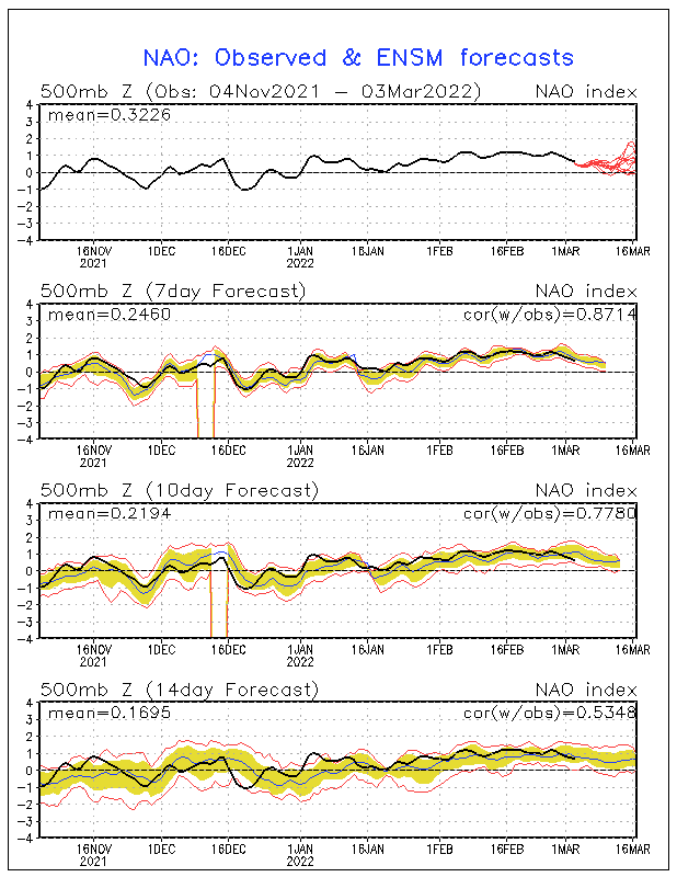
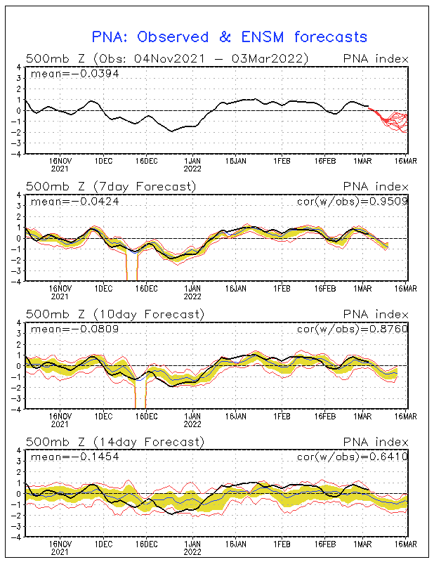
Also, now that the sites are back up, the NAO still remains NEG but SPIKES rapidly for a brief time, only to fall back off once again, and furthermore, the potential return of the PNA pattern (which actually never quite made it to an RNA pattern) ...

Image

Image

Other details are concerning the retrograding block in Eastern Canada, which MIGHT just be a bit fast ... but maybe NOT, but the argument with the PNA pattern to return would likely suggest that the block doesn't come as far west as progged, and hence, the up the OV track seems quite errorneous WITHOUT a 2ndary re-development off the coast. The 12z NOGAPS shows such a re-development, BUT anytime with CAD, the models are almost ALWAYS too aggressive with the coastal trough returning inland off the Carolinas.

There are a LOT of details to be ironed out, including the (mis)handling of the southern stream and which global has the right idea....

For obvious reasons, there are a LOT of potentials regarding whether we're looking 5-6 days down the road at a significant snowstorm in the East or just a mostly significant rainstorm ...
0 likes   

User avatar
Skywatch_NC
Category 5
Category 5
Posts: 10949
Joined: Wed Feb 05, 2003 9:31 pm
Location: Raleigh, NC
Contact:

#14 Postby Skywatch_NC » Wed Jan 28, 2004 10:24 pm

I hope the next round of MESS stays AWAY from my area...we're just trying to thaw and melt from the current snow/ICE situation now. :eek: :eek:

I keep begging my folks that instead of us moving to Raleigh eventually
...let's head to a more temperate climate FREE of wintry threats! :D


BRING ON SPRING, BABY!!!! :D :D :) :)

Eric 8-)
0 likes   


Return to “Winter Weather”

Who is online

Users browsing this forum: No registered users and 5 guests