Thoughts and Map on the two midweek systems!

Winter Weather Discussion

Moderator: S2k Moderators

Forum rules

The posts in this forum are NOT official forecast and should not be used as such. They are just the opinion of the poster and may or may not be backed by sound meteorological data. They are NOT endorsed by any professional institution or STORM2K.

Help Support Storm2K
Message
Author
Guest

Thoughts and Map on the two midweek systems!

#1 Postby Guest » Sun Mar 14, 2004 12:30 pm

Well it seems for the most part the models pretty much agree we will have two systems to deal with this week comming up. Which right nowone thing they dont agree on is which sw will be the stronger system and because of that right now im gonna focus more on precip types and not amounts.

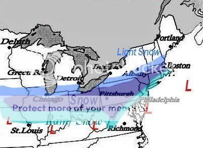
For right now i am gonna focus more on the first system which as well my map below is for. Pretty much expect low pressure to develop out in MO and head into KY then WV and off the S.NJ or Delmarva coast and head ene. With this track i expect a swath of snow to develop from IA into central/Northern IL, IN, OH, and then head into most of PA and then N.NJ, SE NY (Except perhaps LI & the Islands, SN/RN mix) and then sne. Areas from about NYC down towards Philly may see a snow/rain mix and as of now looking to be a cold rain south of there into the Balt/Wash metro areas with perhaps some snow at the onset. Out to the west i expect most everything from along and north of i70 to be all snow and south of there to near the OH river i expect a rain/snow mix. One factor to consider and remember is that you have a better shot at higher snowfall amounts if the snow falls during the night.

I may do a accumulation map after the ooz runs or even perhaps tomorrows 12z runs. No later then that.

Map for system 1.
Image[/img]
0 likes   

User avatar
Chris the Weather Man
Category 2
Category 2
Posts: 746
Joined: Fri Dec 12, 2003 9:49 pm
Location: NJ

#2 Postby Chris the Weather Man » Sun Mar 14, 2004 12:34 pm

King, Map looks good, I am Just on the snow line, JUST!
0 likes   

User avatar
Colin
Category 5
Category 5
Posts: 5086
Joined: Fri Apr 18, 2003 4:17 pm
Location: Catasauqua, PA
Contact:

#3 Postby Colin » Sun Mar 14, 2004 12:41 pm

Map looks good...I still have my doubts on this storm, though.
0 likes   

User avatar
Chris the Weather Man
Category 2
Category 2
Posts: 746
Joined: Fri Dec 12, 2003 9:49 pm
Location: NJ

#4 Postby Chris the Weather Man » Sun Mar 14, 2004 12:46 pm

Colin wrote:Map looks good...I still have my doubts on this storm, though.


you always do.................. (No Offense,Colin)
0 likes   

Guest

#5 Postby Guest » Sun Mar 14, 2004 1:13 pm

Chris the Weather Man wrote:
Colin wrote:Map looks good...I still have my doubts on this storm, though.


you always do.................. (No Offense,Colin)


Well i have a problem because he just said before he posted this at another board that he thinks it looks great which the map there pretty much looked like mine??????
0 likes   

User avatar
Colin
Category 5
Category 5
Posts: 5086
Joined: Fri Apr 18, 2003 4:17 pm
Location: Catasauqua, PA
Contact:

#6 Postby Colin » Sun Mar 14, 2004 1:17 pm

I said it looked great? All I said is I have my doubts? AGAIN, IF YOU HAVE A PROBLEM WITH ME, JUST SAY IT!
0 likes   

Guest

#7 Postby Guest » Sun Mar 14, 2004 1:34 pm

Colin wrote:I said it looked great? All I said is I have my doubts? AGAIN, IF YOU HAVE A PROBLEM WITH ME, JUST SAY IT!


I dont have a problem with you Colin. BUT i have a problem when you say one thing at one site and then say another thing at another site. THAT I HAVE A PROBLEM WITH!
0 likes   

User avatar
Colin
Category 5
Category 5
Posts: 5086
Joined: Fri Apr 18, 2003 4:17 pm
Location: Catasauqua, PA
Contact:

#8 Postby Colin » Sun Mar 14, 2004 2:10 pm

I only meant that I had my doubts about this storm. Capiche?
0 likes   

Cheesy_Poofs
Category 1
Category 1
Posts: 376
Joined: Wed Nov 19, 2003 5:54 pm
Contact:

#9 Postby Cheesy_Poofs » Sun Mar 14, 2004 2:13 pm

KOW- How much are you thinking for the " Rain/Snow " area of the map? I'm thinking 1 to maybe if we're lucky, 2". HPC has me JUST south of the low risk!
0 likes   

Guest

#10 Postby Guest » Sun Mar 14, 2004 2:24 pm

Its ok Colin. Just try to remember to stick with the same thoughts when posting at various sites :)

And to be honest believe it or not i am still in doubt. I guess the winter hasnt helped much which is why.

Cheesy its very hard to say right now alot of timming will depend on amounts. If it comes at night you have a better at some lights amounts if its during the day then your chances are pretty slim. Should know more by later tonight and more so tomorrow.
0 likes   

Cheesy_Poofs
Category 1
Category 1
Posts: 376
Joined: Wed Nov 19, 2003 5:54 pm
Contact:

#11 Postby Cheesy_Poofs » Sun Mar 14, 2004 4:17 pm

Shafted again! It doesn't matter, I'm used to it.

There's always the second s/w wednesday night, but LWX currently going with a low of 32 degrees and rain, mainly because they think ( they said this in there AFD ) climo strongly favors rain in this part of the world at this time.
0 likes   


Return to “Winter Weather”

Who is online

Users browsing this forum: No registered users and 3 guests