The logging industry as you know it is GONE David, there are no MONSTER Companies, no....I'll take that back, the one that's doing the salvage operation in the Rodeo Chediski Burn Area, Sierra Pacific Corp, they are not rapping the land, they are not clear cutting the salvage area, they are very responsible people, I know....we're out in the area at least 3 times a week, well up until the last 4 weeks we were. See, the RC burn area was not 100% burned, there are pockets that were spared, that's the characteristics (sp) of a crown fire, ANYWAYS, they are thinning the old growth trees, YES....they are taking some of the old Yellow Pines (250+ years old) out of the area, why? To let the seed trees produce a healthly new crop!
OK....I'll quite calling them terrorist under one condition, that you quite calling the loggers and the companies a bunch of thiefs, how's that?
Dennis
"save a logger, eat more owl!"
California tree sitters holding firm despite court order
Moderator: S2k Moderators
-
wannabehippie
btw i dont consider those crackpot who take sniper shots at people or put metal stakes thru trees to try and prevent them from being able to be cut down, in any way shape or form, environmentalists
people who do those things are complete wackos and just use "environmentalism" as a cover for acting like maniacs.
if they didnt have that cause they would find another to go off and shoot people. they are crazy.
peace
david
people who do those things are complete wackos and just use "environmentalism" as a cover for acting like maniacs.
if they didnt have that cause they would find another to go off and shoot people. they are crazy.
peace
david
0 likes
-
Rob-TheStormChaser
It's starting again........

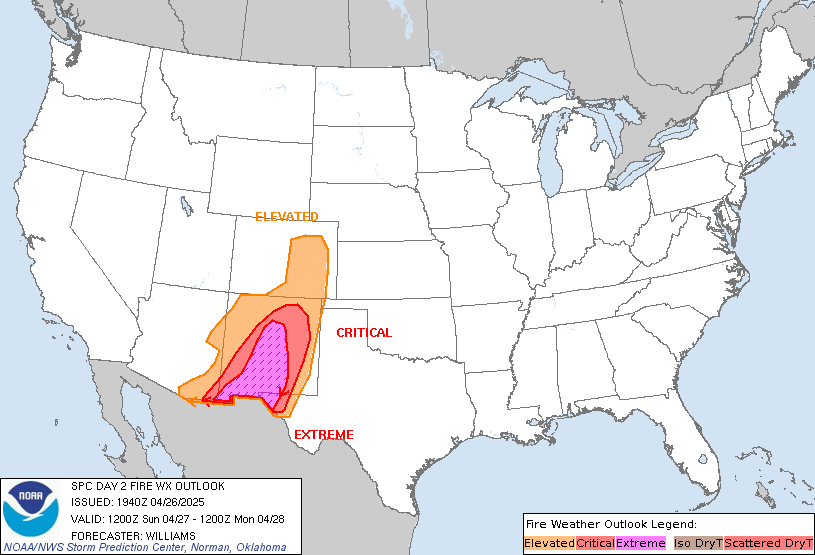
ZCZC SPCFWDDY2 ALL
FNUS22 KWNS 150944
STORM PREDICTION CENTER...NWS/NCEP...NORMAN OK
400 AM CST SAT MAR 15 2003
DAY 2 FIRE WEATHER OUTLOOK...REF AWIPS GRAPHIC PMWI98 KWNS
VALID 161200-171200
...CRITICAL FIRE WEATHER AREA FOR - PORTIONS OF THE SRN
ROCKIES/HIGH PLAINS...
...SYNOPSIS...
AN UPPER TROUGH WILL FROM THE WEST COAST INTO THE ROCKIES
THROUGH THE PERIOD WHILE DEEPENING. STRONG MID LEVEL PRESSURE FALLS
WILL AID IN STRENGTHENING THE SURFACE LEE TROUGH/DRYLINE FROM WRN
KS INTO WRN TX THROUGH THE PERIOD. THE REMAINDER OF THE NATION WILL
SEE LIGHT WINDS AND SEASONABLE RH READINGS.
...CRITICAL FIRE WEATHER AREA 1 - PORTIONS OF SRN/ERN NM...WRN
TX...THE WRN OK PANHANDLE AND FAR SERN CO...
PRIMARY CONDITIONS: SUSTAINED SSWLY WINDS FROM 20 TO 25 MPH WITH
GUSTS TO 40 MPH IN HIGHER TERRAIN / MINIMUM RH READINGS NEAR 15
PERCENT
STRENGTHENING SFC LOW OVER NERN CO WILL AID IN AN INCREASING LOW
LEVEL PRESSURE GRADIENT OVER THE REGION. A DRYLINE IS FCST TO MOVE
EWD AND EXTEND FROM THE LOW SWD INTO SWRN TX. BEHIND THE
DRYLINE...SSWLY WINDS FROM 20 TO 30 MPH WITH GUSTS TO 40 MPH CAN BE
EXPECTED. THERE ARE TWO AREAS WHERE THE SFC WINDS ARE LIKELY TO BE
THE STRONGEST. ONE IS OVER SRN NM/FAR WRN TX...WHERE MID LEVEL
WINDS WILL BE THE STRONGEST. OVER THIS AREA...SUSTAINED WINDS FROM
20 TO 30 MPH WITH GUSTS TO 40 MPH WILL BE LIKELY...ESPECIALLY IN
THE HIGHER TERRAIN. A SFC FRONTAL BOUNDARY WILL MOVE EWD ACROSS THE
AREA AND AID IN SHIFTING THE WINDS TO A MORE WLY DIRECTION AFTER
16/00Z. BEHIND THE FRONT THERE WILL ALSO BE A CHANCE OF SOME LIGHT
PRECIPITATION OVER SCENTRAL NM/FAR WRN TX AFTER 16/06Z. DESPITE MID
LEVEL CLOUD COVER...MINIMUM RH READINGS FROM 15 TO 20 PERCENT WILL
AID IN A CRITICAL FIRE WEATHER THREAT. THE SECOND AREA WHERE SFC
WINDS ARE EXPECTED TO BE STRONG IS NERN NM/NWRN TX PANHANDLE INTO
SERN CO. HERE....A STRONG SFC PRESSURE GRADIENT WILL DEVELOP
THROUGH THE DAY IN RESPONSE TO RAPID PRESSURE FALLS OVER NERN CO.
SUSTAINED WINDS WILL AVG FROM 20 TO 25 MPH WITH GUSTS TO 35 MPH.
MINIMUM RH READINGS FROM 15 TO 20 PERCENT WILL FURTHER EXACERBATE
ALREADY DRY FUELS AND WINDY CONDITIONS.
0 likes
- azsnowman
- Category 5

- Posts: 8591
- Joined: Wed Feb 05, 2003 8:56 pm
- Location: Pinetop Arizona. Elevation 7102' (54 miles west of NM border)
This will just add insult to injury I'm afraid:
(Click on image to enlarge)
Latest Seasonal Assessment - A large storm system produced several inches of precipitation across portions of southern California and Arizona during the second week of February. Further north, unsettled weather across parts of Washington, Oregon, Idaho, Wyoming and Montana helped to increase mountain snow pack but was not enough to result in significant drought improvement. Unfortunately, large moisture deficits are still prevalent across much of the West. Wetter than normal conditions are expected during the next three months or so across southern California, southern Nevada, Arizona, New Mexico, Colorado and Utah. This should result in an improvement of pasture conditions, an increase in soil moisture and benefit to local agriculture. However, due to the large moisture deficits accumulated during past years, the improvement of streamflow and water supplies will be minimal. As a result, water shortages are expected to continue throughout the period. Further north across most of Montana and Wyoming, below normal precipitation will result in the continuation of drought conditions. Further east, drought conditions are expected to continue across western South Dakota and much of North Dakota. Drier than normal conditions are anticipated across the Great Lakes region. As a result, drought conditions are expected to persist through May.
0 likes
Who is online
Users browsing this forum: No registered users and 27 guests