Severe thunderstorms with large hail and high wind roared through north central Maryland on Monday afternoon. Steering flow was weak, thus very heavy rains for a longer period of time over one given location. There was also large hail and wind gusts strong enough to knock down trees in the Baltimore area.
At 4:30 PM EDT, strong outflow developed and roared through Baltimore's eastern suburbs. A huge rain/hail shaft was evident just north of us over in the Towson and Parkville area. Hail up to 1 inch in diameter was reported in Hampton, which is just south of the Towson area in north Baltimore.
After 4:30 PM EDT, storms backbuilt south into east Baltimore and eastern Baltimore County. As this cell interacted with a seabreeze front to it's east, it made a right turn and headed straight into the southeast part of Baltimore County. We had hail up to dime sized and strong Rear Flank Downdraft gusts of 40-50 mph on the back side of this severe cell. There was very frequent and deadly CG lightning embedded in this rain/hail shaft. At one point, visibility was down to near zero as both blinding rains, dime sized hail, and RFD gusts occurred.
Definitely one of the more severe wx days of the year and we only had a 5% probability yesterday. Strong heating, a warm front, and some mid level shear is what resulted in this severe weather yesterday. With mid level rotation evident in these storms, the main threat was large hail.
More severe weather is likely today in isolated places across north central Maryland. But more so into southern PA points north into New York State where damaging wind, large hail, and isolated tornadoes may occur.
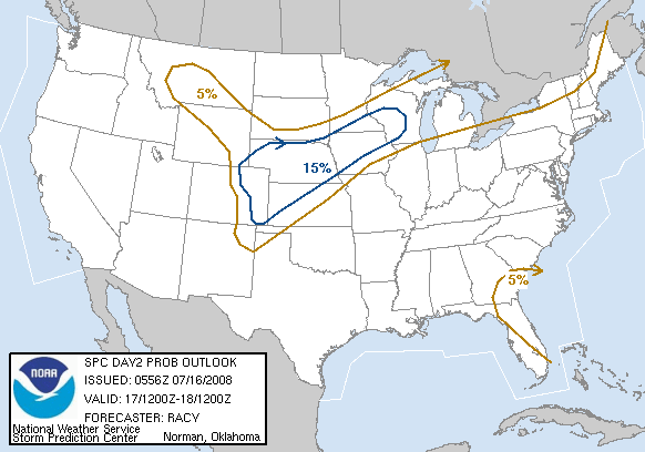
For tomorrow, it gets very dangerous across eastern Nebraska into west central Iowa with damaging winds, hail up to softball sized, and possibly destructive tornadoes as we see another piece of energy race in from the west. With enough moisture in place this time combined with strong instability, we can expect a dangerous severe wx outbreak across the upper Mississippi Valley area tomorrow. This could spread into the Great Lakes tomorrow night as an MCS with damaging winds, isolated tornadoes, and very large hail.
Definitely an active few days with severe weather and I only covered the more significant areas. Severe wx threat exists over the next few days from the central Plains and upper Midwest eastward through the Great Lakes, Mid Atlantic, and northeastern United States.
I'll post storm pics from 5-17-04 soon. Vivid lightning and outflow was evident yesterday.
Jim
Storm reports from Maryland, More dangerous wx expected
Moderator: S2k Moderators
Forum rules
The posts in this forum are NOT official forecast and should not be used as such. They are just the opinion of the poster and may or may not be backed by sound meteorological data. They are NOT endorsed by any professional institution or STORM2K.
Return to “USA & Caribbean Weather”
Who is online
Users browsing this forum: Brent and 84 guests


