Tropical Storm Bill, A GREAT EXAMPLE!

This is the general tropical discussion area. Anyone can take their shot at predicting a storms path.

Moderator: S2k Moderators

Forum rules

The posts in this forum are NOT official forecasts and should not be used as such. They are just the opinion of the poster and may or may not be backed by sound meteorological data. They are NOT endorsed by any professional institution or STORM2K. For official information, please refer to products from the National Hurricane Center and National Weather Service.

Help Support Storm2K
Message
Author
User avatar
HURAKAN
Professional-Met
Professional-Met
Posts: 46086
Age: 38
Joined: Thu May 20, 2004 4:34 pm
Location: Key West, FL
Contact:

Tropical Storm Bill, A GREAT EXAMPLE!

#1 Postby HURAKAN » Thu Jun 10, 2004 4:47 pm

"The interaction of a tropical wave with a mid- to upper-level low resulted in the formation of a surface low pressure area over the Yucatan Peninsula on 28 June. This system was accompanied by a large area of cloudiness and thunderstorms that extended eastward over the northwestern Caribbean Sea".
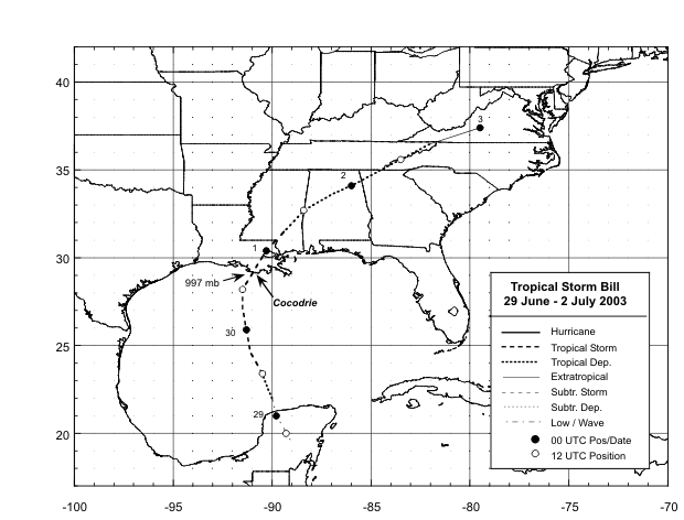
FROM THE NHC/TPC TROPICAL CYCLONE REPORT

Image

I think the formation of TS Bill is a great example of what may happen with this situation in the Caribbean.
Comments are welcome! :)

Sandy Delgado
0 likes   

User avatar
vbhoutex
Storm2k Executive
Storm2k Executive
Posts: 29133
Age: 74
Joined: Wed Oct 09, 2002 11:31 pm
Location: Cypress, TX
Contact:

#2 Postby vbhoutex » Thu Jun 10, 2004 5:06 pm

Unless ALL the conditions are the same as they were with TS Bill we probably won't see anything more than a rain event happen with this system. Hopefully it will go to areas that need the rain if it does materialize.
0 likes   
Skywarn, C.E.R.T.
Please click below to donate to STORM2K to help with the expenses of keeping the site going:
Image

User avatar
Wnghs2007
Category 5
Category 5
Posts: 6836
Age: 36
Joined: Wed Mar 24, 2004 11:14 pm
Location: Gwinnett-Barrow Line; Georgia
Contact:

#3 Postby Wnghs2007 » Thu Jun 10, 2004 5:08 pm

vbhoutex wrote:Unless ALL the conditions are the same as they were with TS Bill we probably won't see anything more than a rain event happen with this system. Hopefully it will go to areas that need the rain if it does materialize.


Hey I would not mind it. We need the rain here in the southeast. I dont care if it becomes tropical or not. WE NEED THE RAIN! :D :wink:
0 likes   

Anonymous

#4 Postby Anonymous » Thu Jun 10, 2004 7:33 pm

Yes, Bill, Larry all seem to have started the same way.
0 likes   

User avatar
HURAKAN
Professional-Met
Professional-Met
Posts: 46086
Age: 38
Joined: Thu May 20, 2004 4:34 pm
Location: Key West, FL
Contact:

#5 Postby HURAKAN » Thu Jun 10, 2004 7:41 pm

~Floydbuster wrote:Yes, Bill, Larry all seem to have started the same way.


Thank you, I forgot Larry.

Sandy Delgado
0 likes   

Anonymous

#6 Postby Anonymous » Thu Jun 10, 2004 7:50 pm

True though. Larry even got up near Hurricane strength in very bad shear...
0 likes   

User avatar
PTrackerLA
Category 5
Category 5
Posts: 5280
Age: 41
Joined: Thu Oct 10, 2002 8:40 pm
Location: Lafayette, LA

#7 Postby PTrackerLA » Thu Jun 10, 2004 8:38 pm

Floydbuster is that Lili in your signature and what do you mean 'how close did they come?"
0 likes   

User avatar
bahamaswx
Category 5
Category 5
Posts: 1545
Joined: Sat Sep 13, 2003 1:11 am
Location: Georgetown, Bahamas

#8 Postby bahamaswx » Thu Jun 10, 2004 8:51 pm

I'd write this disturbance off.
0 likes   

User avatar
george_r_1961
S2K Supporter
S2K Supporter
Posts: 3171
Age: 64
Joined: Sat Oct 12, 2002 9:14 pm
Location: Carbondale, Pennsylvania

#9 Postby george_r_1961 » Thu Jun 10, 2004 9:32 pm

The chances of development are remote IMHO
0 likes   

User avatar
Steve
S2K Supporter
S2K Supporter
Posts: 9628
Joined: Sat Apr 05, 2003 11:41 pm
Location: Gulf of Gavin Newsom

#10 Postby Steve » Thu Jun 10, 2004 10:57 pm

Bill was great. I almost got stranded downtown but made it home to drink a 6 pack of Abita Purple Haze. I ruined a pair of Rockports and got blasted by a car flying through puddles (dryclean the suit). Fun day.

Steve
0 likes   

Anonymous

#11 Postby Anonymous » Fri Jun 11, 2004 12:16 am

PTrackerLA wrote:Floydbuster is that Lili in your signature and what do you mean 'how close did they come?"


Yes. Lili at her peak of 145 mph. Had she not weakened... HOW CLOSE DID THEY COME TO A CATEGORY 4 LANDFALL? VERY CLOSE.
0 likes   

User avatar
HURAKAN
Professional-Met
Professional-Met
Posts: 46086
Age: 38
Joined: Thu May 20, 2004 4:34 pm
Location: Key West, FL
Contact:

#12 Postby HURAKAN » Sat Jun 12, 2004 11:57 am

Days ago I mentioned that TS Bill from last year could be a great example to what is happening in the Gulf of Mexico. Now it looks like I was at least a little in the right side. Let see what happens but this is the closest this system has being from becoming Alex.

Sandy Delgado
0 likes   


Return to “Talkin' Tropics”

Who is online

Users browsing this forum: USTropics and 96 guests