95L INVEST FOR EAST ATLANTIC WAVE

This is the general tropical discussion area. Anyone can take their shot at predicting a storms path.

Moderator: S2k Moderators

Forum rules

The posts in this forum are NOT official forecasts and should not be used as such. They are just the opinion of the poster and may or may not be backed by sound meteorological data. They are NOT endorsed by any professional institution or STORM2K. For official information, please refer to products from the National Hurricane Center and National Weather Service.

Help Support Storm2K
Message
Author
User avatar
cycloneye
Admin
Admin
Posts: 148496
Age: 69
Joined: Thu Oct 10, 2002 10:54 am
Location: San Juan, Puerto Rico

#41 Postby cycloneye » Tue Jul 06, 2004 7:25 am

Steve H. wrote:I don't know, the disturbance looks pretty decent to me. I give better than even chances that it will develop, in a couple of days that is. It may get overrun by the wave behind it though; at least they may compete; which would not be good for development. :uarrow:


Agree Steve about the systems being too close one to another they may cancel each other the chances for development but I notice that the one now emerging Africa is a bit farther north in latitud that 95L and that doesn't bold well because more cooler waters are more north away from 10n but whatever happens with those systems we have at least something to watch and talk about as the atlantic has been quiet.
0 likes   
Visit the Caribbean-Central America Weather Thread where you can find at first post web cams,radars
and observations from Caribbean basin members Click Here

Steve H.
Category 5
Category 5
Posts: 2163
Joined: Sat Oct 19, 2002 9:06 am
Location: Palm Bay, Florida

#42 Postby Steve H. » Tue Jul 06, 2004 9:24 am

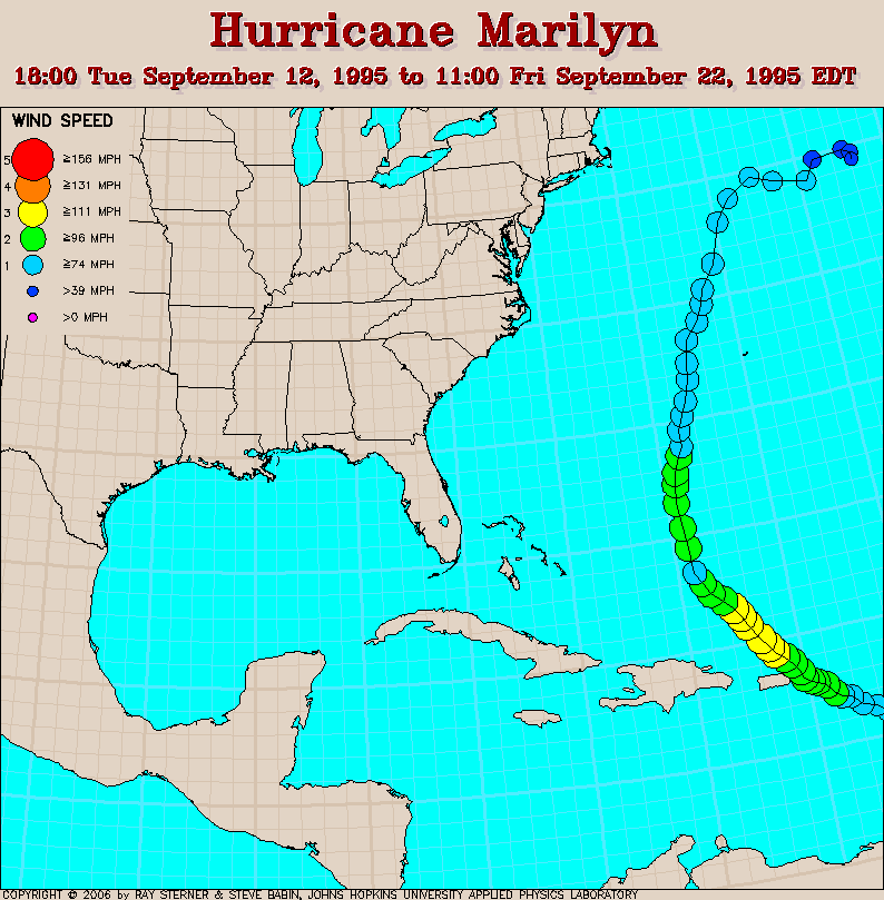
Yep Luis, 'tis the season. YOU need to watch these closely since this looks like an active CV season. What was the one you got in '95.....Marilyn?? :?:
0 likes   

User avatar
Lindaloo
Category 5
Category 5
Posts: 22658
Joined: Sat Mar 29, 2003 10:06 am
Location: Pascagoula, MS

#43 Postby Lindaloo » Tue Jul 06, 2004 9:43 am

I know Luis experienced Georges in 98. :eek:
0 likes   

User avatar
HURAKAN
Professional-Met
Professional-Met
Posts: 46086
Age: 38
Joined: Thu May 20, 2004 4:34 pm
Location: Key West, FL
Contact:

#44 Postby HURAKAN » Tue Jul 06, 2004 10:01 am

06/0530 UTC 10.7N 21.7W T1.0/1.0 95

Our wave doesn't look very impressive today but still it may be organizing since its winds have increased from yesterday, too weak, to today 25 Knots.
0 likes   

OtherHD
Category 5
Category 5
Posts: 2192
Age: 39
Joined: Tue Oct 08, 2002 10:01 am
Location: San Antonio, TX

#45 Postby OtherHD » Tue Jul 06, 2004 10:31 am

Those are just estimates...
0 likes   

User avatar
HURAKAN
Professional-Met
Professional-Met
Posts: 46086
Age: 38
Joined: Thu May 20, 2004 4:34 pm
Location: Key West, FL
Contact:

#46 Postby HURAKAN » Tue Jul 06, 2004 10:33 am

Image
0 likes   

DoctorHurricane2003

#47 Postby DoctorHurricane2003 » Tue Jul 06, 2004 10:37 am

Yes the system looks very interesting, even though it is more disorganized today. However, upper-level conditions have and should continue to improve for the formation of a tropical cyclone. It probably will not develop today, but we should watch it tomorrow.
0 likes   

Steve H.
Category 5
Category 5
Posts: 2163
Joined: Sat Oct 19, 2002 9:06 am
Location: Palm Bay, Florida

#48 Postby Steve H. » Tue Jul 06, 2004 10:48 am

Disagree with ya there Hurakan, think it looks better now. Deep convection is building at about 9N. Think it will reform its center to the SW. But lets watch 8-)
0 likes   

User avatar
cycloneye
Admin
Admin
Posts: 148496
Age: 69
Joined: Thu Oct 10, 2002 10:54 am
Location: San Juan, Puerto Rico

#49 Postby cycloneye » Tue Jul 06, 2004 11:10 am

Steve H. wrote:Yep Luis, 'tis the season. YOU need to watch these closely since this looks like an active CV season. What was the one you got in '95.....Marilyn?? :?:


First was Luis (Cat 4)which came very close to hit PR and then came Marilyn (Cat 2) which clipped the northeastern corner but Culebra and Vieques saw plenty of damage from it.
0 likes   
Visit the Caribbean-Central America Weather Thread where you can find at first post web cams,radars
and observations from Caribbean basin members Click Here

chadtm80

#50 Postby chadtm80 » Tue Jul 06, 2004 11:16 am

cycloneye wrote:
Steve H. wrote:Yep Luis, 'tis the season. YOU need to watch these closely since this looks like an active CV season. What was the one you got in '95.....Marilyn?? :?:


First was Luis (Cat 4)which came very close to hit PR and then came Marilyn (Cat 2) which clipped the northeastern corner but Culebra and Vieques saw plenty of damage from it.


Image
0 likes   

Steve H.
Category 5
Category 5
Posts: 2163
Joined: Sat Oct 19, 2002 9:06 am
Location: Palm Bay, Florida

#51 Postby Steve H. » Tue Jul 06, 2004 11:33 am

Yeah, I had a friend who went down Puerto Rico to help get the relay stations and the power back on the eastern side of the island. That must have been Marilyn.
0 likes   

User avatar
wxman57
Moderator-Pro Met
Moderator-Pro Met
Posts: 23080
Age: 68
Joined: Sat Jun 21, 2003 8:06 pm
Location: Houston, TX (southwest)

#52 Postby wxman57 » Tue Jul 06, 2004 11:44 am

Steve H. wrote:I don't know, the disturbance looks pretty decent to me. I give better than even chances that it will develop, in a couple of days that is. It may get overrun by the wave behind it though; at least they may compete; which would not be good for development. :uarrow:


Not much if any circulation present any more. Just an average wave now, with perhaps a 5-10% chance of developing.
0 likes   

User avatar
cycloneye
Admin
Admin
Posts: 148496
Age: 69
Joined: Thu Oct 10, 2002 10:54 am
Location: San Juan, Puerto Rico

#53 Postby cycloneye » Tue Jul 06, 2004 11:49 am

wxman57 wrote:
Steve H. wrote:I don't know, the disturbance looks pretty decent to me. I give better than even chances that it will develop, in a couple of days that is. It may get overrun by the wave behind it though; at least they may compete; which would not be good for development. :uarrow:


Not much if any circulation present any more. Just an average wave now, with perhaps a 5-10% chance of developing.


Agree Chris that the system doesn't look as organized as yesterday however I am somewhat surprised that at least it has mantained some convection with it and maybe further west around 50w it may organize once again but regardless what it doesthis is the best well organized wave that has emerged Africa this year and it sends a signal about active season in the Cape Verde area and we are talking about as before this the atlantic was very quiet.I would want to see how the global models are showing 95L in latest runs.
0 likes   
Visit the Caribbean-Central America Weather Thread where you can find at first post web cams,radars
and observations from Caribbean basin members Click Here

User avatar
senorpepr
Military Met/Moderator
Posts: 12542
Age: 43
Joined: Fri Aug 22, 2003 9:22 pm
Location: Mackenbach, Germany
Contact:

#54 Postby senorpepr » Tue Jul 06, 2004 3:15 pm

HURAKAN wrote:06/0530 UTC 10.7N 21.7W T1.0/1.0 95

Our wave doesn't look very impressive today but still it may be organizing since its winds have increased from yesterday, too weak, to today 25 Knots.


Looks like SSD also notes a weakening trend...
06/1745 UTC 10.6N 24.1W TOO WEAK 95
0 likes   

Rainband

#55 Postby Rainband » Tue Jul 06, 2004 3:42 pm

next :lol:
0 likes   

User avatar
Thunder44
Category 5
Category 5
Posts: 5922
Age: 44
Joined: Mon Jun 09, 2003 7:53 pm
Location: New York City

#56 Postby Thunder44 » Tue Jul 06, 2004 3:50 pm

Looks like the other wave just behind it 95L weakened too coming of Africa. A little bit of excitment, but at the end climatology rules. :(
0 likes   

User avatar
senorpepr
Military Met/Moderator
Posts: 12542
Age: 43
Joined: Fri Aug 22, 2003 9:22 pm
Location: Mackenbach, Germany
Contact:

#57 Postby senorpepr » Tue Jul 06, 2004 4:04 pm

Thunder44 wrote:but at the end climatology rules.


Well said.
0 likes   

User avatar
Lindaloo
Category 5
Category 5
Posts: 22658
Joined: Sat Mar 29, 2003 10:06 am
Location: Pascagoula, MS

#58 Postby Lindaloo » Tue Jul 06, 2004 4:04 pm

Rainband wrote:next :lol:


ROFL!!! :lol:
0 likes   

Janie34
Tropical Storm
Tropical Storm
Posts: 232
Joined: Sun Jun 13, 2004 5:40 pm
Location: coastal Alabama

#59 Postby Janie34 » Tue Jul 06, 2004 5:03 pm

Hrmmm. Something strikes me as interesting about this pattern, though. It is early in the season and the African train is making a move. There is a lot of talk about climatology.

While I agree that in many instances it is quite useful for month-to-month and yearly events, I doubt we posess enough information to make truly qualified judgements about the climate or what is or is not normal. Isn't "normal" a relative term? After all, how long have we as human beings kept reliable Wx records? 100 or even 200 years of accurate record-keeping is simply not enough data. I think sometimes the best we can do is make educated guesses, especially concerning such things as global pattern changes. TPC mentions that they have not known a tropical cyclone to form that far east this early. I'm just pointing out that hurricanes have been forming and moving across the pond looooong before anyone thought of attempting to predict their formation and path of movement. Millenia, even. It is possible that what we consider normal may be an abnormality. Given the great lengths of time in Earth's existence, humankind only accounts for a mere blink of the eye.

OTOH, all we have to go on is our records and our understanding of the atmosphere and all the associated dynamics. I just think its something interesting to ponder from time to time.

<We now return you to your regularly scheduled watch on the tropics>
0 likes   


Return to “Talkin' Tropics”

Who is online

Users browsing this forum: stormsurf and 112 guests