Bonnie Advisories

Moderator: S2k Moderators

Message
Author
User avatar
yoda
Category 5
Category 5
Posts: 7874
Joined: Tue Jan 13, 2004 3:51 pm
Location: Springfield VA (20 mins south of DC)
Contact:

#661 Postby yoda » Wed Aug 04, 2004 9:49 am

Thunder44 wrote:How can you say it can become a tropical storm in the 24 hours and say at the same time it could dissapate later today :?:


NHC is covering both bases, in case it dissapates its good. If it becomes a TS, no one can say that the NHC didn't say so.
0 likes   

Stormchaser16
Category 5
Category 5
Posts: 1013
Joined: Thu Aug 21, 2003 10:25 pm
Location: NW Jersey
Contact:

#662 Postby Stormchaser16 » Wed Aug 04, 2004 9:49 am

And this was one of my concerns when issuing my forecast synopsis....

The system looks very weak right now, and the western edge of the ridge could wind up to be just strong enough to keep it further south, yet im still convinced a cold front will come through and turn it more towards the north(unless the system sits really far south)
0 likes   

Brent
S2K Supporter
S2K Supporter
Posts: 38090
Age: 36
Joined: Sun May 16, 2004 10:30 pm
Location: Tulsa Oklahoma
Contact:

#663 Postby Brent » Wed Aug 04, 2004 9:50 am

[quote="Thunder44"]How can you say it can become a tropical storm in the 24 hours and say at the same

If it keeps moving at 20-25 mph it will dissipate, but if it slows down as forecast it could become Bonnie.
0 likes   
#neversummer

User avatar
yoda
Category 5
Category 5
Posts: 7874
Joined: Tue Jan 13, 2004 3:51 pm
Location: Springfield VA (20 mins south of DC)
Contact:

#664 Postby yoda » Wed Aug 04, 2004 9:50 am

I wasn't arguing with ya Derek. I respect you more than I do NHC. (If ya working at NHC oops!) Now, no hate toward NHC though. But this is like one of those situations where, "Your darned if you do and darned if you don't."
0 likes   

User avatar
yoda
Category 5
Category 5
Posts: 7874
Joined: Tue Jan 13, 2004 3:51 pm
Location: Springfield VA (20 mins south of DC)
Contact:

#665 Postby yoda » Wed Aug 04, 2004 9:51 am

yoda wrote:New tracking maps at 11 take TD#2 right over DR.. which would rip this to shreds...

http://www.wunderground.com/tropical/tr ... _5day.html


Again, since my comp refuses to do so, could someone post the image of the 5 day forecast? Thanks. :D

**Matt angry at computer :grr: :grr: **
0 likes   

jlauderdal
S2K Supporter
S2K Supporter
Posts: 7183
Joined: Wed May 19, 2004 5:46 am
Location: NE Fort Lauderdale
Contact:

#666 Postby jlauderdal » Wed Aug 04, 2004 9:52 am

Thunder44 wrote:How can you say it can become a tropical storm in the 24 hours and say at the same time it could dissapate later today :?:


CYA...you get it right either way. Honestly, it could go either way.
0 likes   

User avatar
Dan
Tropical Depression
Tropical Depression
Posts: 93
Joined: Sun Nov 09, 2003 11:04 am
Location: Marion North Carolina
Contact:

Re: 11 A.M. TD 2: Not dead, but on life support

#667 Postby Dan » Wed Aug 04, 2004 9:53 am

yoda wrote:
What I find fascinating in this statement are 3 things which we can elaborate on later...

1.) Winds ARE STILL 35 mph
2) The depression STILL has a chance to become a TS.
3.) The depression is moving toward the west near 25 mph...41 km/hr. Agradual reduction in forward speed with a turn to the west-northwest is expected over the next 24 hours.


TD 2 is small in size, like Alex was...if the LLC can become established, TD 2 could intensify fairly quickly. I think that may be the answer to question #2.
0 likes   

User avatar
HURAKAN
Professional-Met
Professional-Met
Posts: 46086
Age: 38
Joined: Thu May 20, 2004 4:34 pm
Location: Key West, FL
Contact:

#668 Postby HURAKAN » Wed Aug 04, 2004 9:54 am

Image
0 likes   

User avatar
yoda
Category 5
Category 5
Posts: 7874
Joined: Tue Jan 13, 2004 3:51 pm
Location: Springfield VA (20 mins south of DC)
Contact:

#669 Postby yoda » Wed Aug 04, 2004 9:54 am

We shall see what they say in the 11 AM discussion... :D
0 likes   

User avatar
HURAKAN
Professional-Met
Professional-Met
Posts: 46086
Age: 38
Joined: Thu May 20, 2004 4:34 pm
Location: Key West, FL
Contact:

#670 Postby HURAKAN » Wed Aug 04, 2004 9:56 am

Still the discussion for the depression is not ready. :(
0 likes   

User avatar
yoda
Category 5
Category 5
Posts: 7874
Joined: Tue Jan 13, 2004 3:51 pm
Location: Springfield VA (20 mins south of DC)
Contact:

#671 Postby yoda » Wed Aug 04, 2004 9:57 am

HURAKAN wrote:Still the discussion for the depression is not ready. :(


Well, that's "depressing." :lol: :lol:
0 likes   

jlauderdal
S2K Supporter
S2K Supporter
Posts: 7183
Joined: Wed May 19, 2004 5:46 am
Location: NE Fort Lauderdale
Contact:

#672 Postby jlauderdal » Wed Aug 04, 2004 10:01 am

Derek Ortt wrote:actaully, there is no circ based upon recon. If I have to restart updates later, I will.

I guarantee you best track will have the feature as a wave at the present time, proving me correct. This was continued for continuity only


I thought they used objective criteria and not subjective. Derek is right, no llc no td. NHC needs to follow their own rules.
0 likes   

User avatar
yoda
Category 5
Category 5
Posts: 7874
Joined: Tue Jan 13, 2004 3:51 pm
Location: Springfield VA (20 mins south of DC)
Contact:

#673 Postby yoda » Wed Aug 04, 2004 10:03 am

yeah Discussion time!


an Air Force reconnaissance aircraft investigating the depression
found a very sharp wind shift and some south-southwestly winds at
2500 ft...but was not able to close off a circulation. Wind
reports in the Windward Islands this morning were also more
suggestive of a tropical wave structure. While strictly speaking
this system is not currently a tropical cyclone...we are electing
to maintain advisories this morning. Most of the dynamical model
guidance indicates that the system will soon slow down and turn to
the northwest...and if this occurs a closed circulation could
re-develop.
The initial motion remains 275/22. The system is on the south side
of a low to mid level ridge...which large scale-models forecast
should weaken as an unseasonably strong deep-layer trough develops
over the eastern United States and western Atlantic. This suggests
the system should slow and turn northwestward...and then possibly
northward later in the forecast period. The more sophisticated GFDL
and global models remain in good agreement on this turn to the
northwest and then north...although they have been generally
trending westward. The simpler steering guidance...such as the BAM
models...keep the system on more of a west-northwesterly track. A
weaker or dissipating system would be more likely to follow this
latter alternative. The official forecast is shifted a little west
of the previous advisory but basically is consistent with the
global model guidance. This is a very low confidence forecast.
The official intensity forecast is less aggressive than the previous
one. There is southwesterly shear ahead of the depression...and
the current track forecast takes the system over the mountainous
terrain of Hispaniola. This forecast presumes...of course...that
the depression does not dissipate later today.

Forecaster Franklin

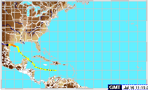
forecast positions and Max winds

initial 04/1500z 13.8n 62.7w 30 kt
12hr VT 05/0000z 14.5n 65.4w 30 kt
24hr VT 05/1200z 15.6n 68.2w 35 kt
36hr VT 06/0000z 17.5n 70.5w 40 kt
48hr VT 06/1200z 20.0n 71.5w 30 kt
72hr VT 07/1200z 25.0n 72.0w 35 kt
96hr VT 08/1200z 29.0n 71.0w 40 kt
120hr VT 09/1200z 34.0n 68.0w 45 kt
0 likes   

Guest

I say this is similar to Claudette

#674 Postby Guest » Wed Aug 04, 2004 10:04 am

Image

Does anyone disagree?
0 likes   

Josephine96

#675 Postby Josephine96 » Wed Aug 04, 2004 10:05 am

I hope the TD holds together.. We need to keep the action in the tropics going.. Plus if it's forecast to slow down.. That could help it out
0 likes   

User avatar
yoda
Category 5
Category 5
Posts: 7874
Joined: Tue Jan 13, 2004 3:51 pm
Location: Springfield VA (20 mins south of DC)
Contact:

#676 Postby yoda » Wed Aug 04, 2004 10:06 am

jlauderdal wrote:
Derek Ortt wrote:actaully, there is no circ based upon recon. If I have to restart updates later, I will.

I guarantee you best track will have the feature as a wave at the present time, proving me correct. This was continued for continuity only


I thought they used objective criteria and not subjective. Derek is right, no llc no td. NHC needs to follow their own rules.


See discussion in TD#2 still alive post.
0 likes   

Rainband

Re: I say this is similar to Claudette

#677 Postby Rainband » Wed Aug 04, 2004 10:07 am

alxfamlaw wrote:Image

Does anyone disagree?
Thats an old map
0 likes   

Brent
S2K Supporter
S2K Supporter
Posts: 38090
Age: 36
Joined: Sun May 16, 2004 10:30 pm
Location: Tulsa Oklahoma
Contact:

#678 Postby Brent » Wed Aug 04, 2004 10:07 am

So technically speaking, the TD is an open wave.

SLOW DOWN TD 2!!!!!!!!!!!!!!!!!!!!!!!!!!!!!!!!
0 likes   
#neversummer

User avatar
HURAKAN
Professional-Met
Professional-Met
Posts: 46086
Age: 38
Joined: Thu May 20, 2004 4:34 pm
Location: Key West, FL
Contact:

#679 Postby HURAKAN » Wed Aug 04, 2004 10:07 am

Josephine96 wrote:I hope the TD holds together.. We need to keep the action in the tropics going.. Plus if it's forecast to slow down.. That could help it out


I agree, after two months stormless finally some action comes and I don't want to go so quickly.
0 likes   

User avatar
yoda
Category 5
Category 5
Posts: 7874
Joined: Tue Jan 13, 2004 3:51 pm
Location: Springfield VA (20 mins south of DC)
Contact:

#680 Postby yoda » Wed Aug 04, 2004 10:09 am

Agree with you, the council does Hurakan. :D
0 likes   


Return to “2004”

Who is online

Users browsing this forum: No registered users and 1 guest