
I still think the center of Bonnie's circulation is on the northeast edge of that blob of convection (where you see the convection firing in a "pinhead" shape). That would suggest a WNW/NW motion. This is more clearly seen on closeup IR loops with shorter interval time...
http://wwwghcc.msfc.nasa.gov/GOES/goeseastconusir.html
Bonnie Advisories
Moderator: S2k Moderators
-
Sean in New Orleans

- Category 5

- Posts: 1794
- Joined: Thu Aug 28, 2003 7:26 pm
- Location: New Orleans, LA 30.0N 90.0W
- Contact:
I'm not sure, actually...I still think it's in the center of the convection...it appears to be...we'll know more in a few hours, but, I'm not going to be up. I've got the annual physical in the morning and I'm too hungry to stay up much longer!! http://www.ssd.noaa.gov/PS/TROP/DATA/RT ... -loop.html
0 likes

Bonnie...looks like a sheared triangle.
MW
MW
0 likes
Updating on the twitter now: http://www.twitter.com/@watkinstrack
-
Stormcenter
- S2K Supporter

- Posts: 6689
- Joined: Wed Sep 03, 2003 11:27 am
- Location: Houston, TX
She's trying
I got to give her credit she is trying her best to organized despite the shear. She looks to be passing 90 degree mark as
I type this. I'm really not 100% sure of the motion but best guess is WNW. IMO
http://www.rap.ucar.edu/weather/satelli ... itype=irbw
I type this. I'm really not 100% sure of the motion but best guess is WNW. IMO
http://www.rap.ucar.edu/weather/satelli ... itype=irbw
0 likes
Bonnie and TD#3 future Charley...
Looking at the latest shows Tropical Storm Bonnie at 50 mph while TD#3 is at 35 mph with higher gusts at 11 PM EDT. Both systems could intensify and both systems could have potential impacts on the United States and the east central Gulf Of Mexico.
Taking a look at each system in detail starting with Bonnie. At 11 PM EDT, the center of tropical storm Bonnie was located near latitude 23.4 north, longitude 89.2 west or about 390 miles south of the mouth of the Mississippi River. Bonnie is moving toward the northwest at near 6 mph and a gradual turn toward the north is expecte over the next day or two.
Maximum sustained winds are up to near 50 mph with higher gusts. Bonnie has a small wind field with tropical storm force winds extending outward up to only 30 miles from the center. Slow strengthening is expected over the next 24 hours. Minimum central pressure as measured by hurricane hunter aircraft is 1006 mb or 29.71 inches. Anyone living or vacationing in the northeast Gulf coast from Florida to Louisiana need to pay special attention to this storm system as it near the coast. Watches and warnings maybe neccessary later Tuesday into Wednesday.
Bonnie isn't the only game in the tropics we need to worry about. We got Tropical Depression #3 in the eastern Caribbean. At 11 PM EDT, TD#3 was centered near latitude 12.4 north, longitude 64.1 west or about 165 miles west of Grenada. Maximum sustained winds are up near 35 mph with higher gusts. Barbados reported a wind gust to 53 mph earlier Monday as the most intense squalls moved on through there. Some strengthening is likely over the next day or two followed by a more rapid strengthening as this system is forecast to move over the northwestern Caribbean later in the week. TD#3 could become a tropical storm later tonite or on Tuesday. Minimum central pressure is 1010 mb or 29.83 inches.
Looking at the future tracks and intensities of Bonnie show the system intensifying slowly to strong tropical storm strength between now and Thursday morning. Some northerly shear has kept this system from intensifying much greater than it is now and it is not showing signs of intensifying tonight. It may even weaken some overnight into the morning hours this morning. However a more favorable environment aloft is possible with Bonnie over the next few days for further strengthening. There is a definite chance that this could become a hurricane prior to landfall along the Florida Panhandle sometime on Thursday. Should this become a hurricane, category 1 or 2 type winds are a possibility. NHC intensity guidance shows this as a strong tropical storm with hurricane force gusts likely. However we must keep in mind that this system is very small in size, thus the impacts will be felt in more localized areas as opposed to what we see in a larger sized tropical cyclone. However we must also keep in mind that intensity is much more difficult to forecast than the track of tropical cyclones.
The system I'm even more concerned about is Tropical Depression #3 spinning just west of the Lesser Antillies. As this system continues west northwestward, the forecast is for slow strengthening followed by a more rapid strengthening as this thing passes south of Haiti and the Dominican Republic. Some models indicate this thing could easily become a major hurricane by the end of this week. Some areas that need to be on guard with this thing include the Yucatan Peninsula, the Yucatan Channel, Jamaica, the Cayman Islands, the Isle of Youth, western Cuba, and potentially even Florida and extending westward into the entire US gulf coast by thie weekend and into early next week. TD#3 is a larger sized system with alot more real estate to cover with more land masses potentially affected. All interests in the west central Caribbean and into the Gulf Of Mexico are reccommended to keep a close eye on this system for the next several days as this could be a major storm system that could prove dangerous.
Jim
0 likes
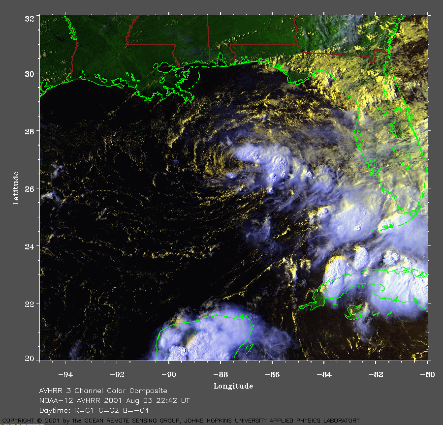
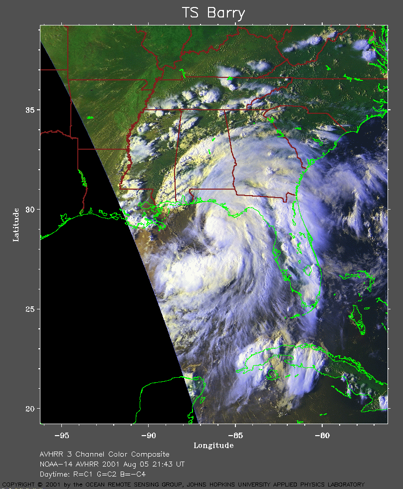
Before writing Bonnie off, let's remember what Gulf storms can do.
Case in point - TS Barry of 2001:
Late afternoon, August 3rd:
http://www.atmos.umd.edu/~stevenb/hurr/ ... 3_2242.gif
Late afternoon, August 5th:
http://www.atmos.umd.edu/~stevenb/hurr/ ... 5_2143.gif
Approaching troughs can change the synoptic environment dramatically in this region...huge implications for storm structure and strength.
Last edited by tallywx on Tue Aug 10, 2004 1:56 am, edited 1 time in total.
0 likes
-
Guest
BONNIE likely FL Panhandle then UP East coast
With this sort of 500 MB folks there is only One possible solution... for Bonnie to take.
Look at this friggin MONSTER trough for Mid AUG.
Once Bonnie catches the trough -- she will race North or NNE ort NE make landfall between Mobile and Tampa then UP the front stalled over the East coast..... into GA SC NC and VA

as for intensity... dont know yet. But the overall synoptic pattern is clearly set....
Look at this friggin MONSTER trough for Mid AUG.
Once Bonnie catches the trough -- she will race North or NNE ort NE make landfall between Mobile and Tampa then UP the front stalled over the East coast..... into GA SC NC and VA
as for intensity... dont know yet. But the overall synoptic pattern is clearly set....
0 likes
-
TheWeatherZone
- Tropical Depression

- Posts: 72
- Joined: Sat Sep 13, 2003 12:24 pm
- Location: Audubon NJ
- Contact:
and to see a Polar Vortex up near Hudson Bay in August, whew this represents a winter pattern if you ask me. Definitely one of the more unusually cool patterns I've seen given the time of year here in the Mid Atlantic area. But to see two cold fronts rush down into the north central Gulf Of Mexico in August is amazing. It's definitely something we don't hear about often.
Jim
Jim
0 likes
-
soonertwister
- Category 5
- Posts: 1091
- Joined: Mon Jun 16, 2003 2:52 pm
tallywx wrote:Before writing Bonnie off, let's remember what Gulf storms can do.
Case in point - TS Barry of 2001:
Late afternoon, August 3rd:
(images deleted)
Approaching troughs can change the synoptic environment dramatically in this region...huge implications for storm structure and strength.
tallywx,
With really large graphics like this, you ought to just post links to the pictures, rather than post them. Not only does the size play havoc with the readability of the thread (causes text to stretch well beyond normal screen width), it also wastes a lot of bandwidth and significantly slows down the download process for those without broadband connections.
I'm just asking that you consider doing this with posts in the future.
Thanks for your understanding.
P.S. - The images you have posted are copyrighted. That means unless you have prior permission from the owner of the images, you cannot use them in your posts.
0 likes
-
Guest
soonertwister
your understanding of copy right law blows chunks....
your statement here is 1000000% wrong.
P.S. - The images you have posted are copyrighted. That means unless you have prior permission from the owner of the images, you cannot use them in your posts.
The PICTURES are GOVT property NOT private property. Those sat pictures were taken by NOAA a govt organization and NOT by say accu weather.
Second since they are paid for by ME -- and you-- the picture has ve certain community rights status.
as long as the satellite pics are NOT altered to show or imply that I took them -- then it is perfectly legal to post weather satellite pictures in a weather BB.
In this case the satellite pictures of Barry were taken by the AVHRR / NOAA and released thru John Hopkins. As long as that stamp is still on the picture NO harm has been done.
If your wretched understanding of the law was correct a Meteorology professor using satellite pictures in his class room could get sued.
0 likes
-
Matthew5
TROPICAL STORM BONNIE
153
WTNT42 KNHC 100844
TCDAT2
TROPICAL STORM BONNIE DISCUSSION NUMBER 9
NWS TPC/NATIONAL HURRICANE CENTER MIAMI FL
5 AM EDT TUE AUG 10 2004
IN SATELLITE IMAGERY...BONNIE REMAINS A RATHER UNIMPRESSIVE TROPICAL
CYCLONE...WITH A SMALL CDO...CENTRAL DENSE OVERCAST...AND BANDING
THAT IS LIMITED BUT INCREASING. THE CENTRAL CONVECTION HAS BEEN
RATHER PERSISTENT THOUGH...AND DATA FROM A RECONNAISSANCE AIRCRAFT
CURRENTLY INVESTIGATING BONNIE SHOWS THAT THE CYCLONE IS
MAINTAINING ITS ORGANIZATION AND STRENGTH. THE CREW REPORTED A 10
MILE WIDE EYE...ALMOST UNHEARD OF IN A SYSTEM OF THIS INTENSITY. THE PEAK FLIGHT-LEVEL WINDS WERE 49 KT...AND A DROPSONDE IN THE
SOUTHEAST QUADRANT REPORTED SURFACE WINDS OF 43 KT. BASED ON THESE
DATA...THE INITIAL INTENSITY ESTIMATE IS HELD AT 45 KT FOR THIS
ADVISORY.
SMALL TROPICAL CYCLONES SUCH AS BONNIE ARE PRONE TO RAPID CHANGES IN
INTENSITY...EITHER UP OR DOWN. THERE ARE A COUPLE OF FACTORS THAT
WOULD ARGUE FOR SUBSTANTIAL STRENGTHENING OVER THE NEXT DAY OR TWO.
FIRST...ALTHOUGH BONNIE IS CURRENTLY EXPERIENCING SOME NORTHERLY
SHEAR...IT SHOULD BE MOVING UNDER LIGHT ANTICYCLONIC FLOW IN THE
CENTRAL GULF LATER TODAY. SECOND...THE FORECAST TRACK TAKES BONNIE
OVER OR VERY NEAR A POOL OF DEEP WARM WATER IN THE NORTH-CENTRAL
GULF. A MITIGATING FACTOR WOULD BE THE RELATIVELY DRY AIR IN THE
NORTHWESTERN GULF. THE LAST TWO RUNS OF BOTH THE GFDL AND SHIPS
MODELS MAKE BONNIE A HURRICANE PRIOR TO LANDFALL. THE GFS DOES NOT
SHOW INTENSIFICATION...BUT IN FACT BARELY ACKNOWLEDGES BONNIE'S
EXISTENCE DUE TO THE CYCLONE'S SMALL SIZE. THE OFFICIAL FORECAST IS
ADJUSTED UPWARD FROM THE PREVIOUS ADVISORY...AND CALLS FOR BONNIE
TO REACH HURRICANE STRENGTH WITHIN 48 HOURS. HOWEVER...IT IS STILL
BELOW THE SHIPS GUIDANCE...AND IS CONSIDERABLY BELOW THE GFDL
GUIDANCE.
THE CURRENT MOTION ESTIMATE IS 295/7...SOMEWHAT TO THE LEFT OF THE
PREVIOUS TRACK. MOST OF THE 3-DIMENSIONAL DYNAMICAL GUIDANCE TURNS
BONNIE SHARPLY NORTHWARD AND THEN NORTHEASTWARD AHEAD OF A
MID-LEVEL TROUGH ABOUT TO ENTER THE WESTERN GULF. THE OFFICIAL
FORECAST IS ADJUSTED A LITTLE TO THE LEFT OF THE PREVIOUS TRACK FOR
THE FIRST 24 HOURS...IS FAIRLY SIMILAR THEREAFTER...AND IS IN BEST
AGREEMENT WITH THE GFDL GUIDANCE.
THE NOAA G-IV JET WILL CONDUCT A MISSION IN THE ENVIRONMENT OF
BONNIE THIS EVENING TO IMPROVE THE INITIAL CONDITION FOR THE
NUMERICAL TRACK GUIDANCE MODELS.
FORECASTER FRANKLIN
FORECAST POSITIONS AND MAX WINDS
INITIAL 10/0900Z 23.6N 90.1W 45 KT
12HR VT 10/1800Z 24.2N 90.7W 50 KT
24HR VT 11/0600Z 25.5N 90.7W 55 KT
36HR VT 11/1800Z 26.6N 89.8W 60 KT
48HR VT 12/0600Z 28.0N 88.0W 65 KT
72HR VT 13/0600Z 33.5N 81.0W 25 KT...INLAND
96HR VT 14/0600Z...ABSORBED INTO FRONTAL ZONE
0 likes
-
Anonymous
-
george_r_1961

- S2K Supporter
- Posts: 3171
- Age: 64
- Joined: Sat Oct 12, 2002 9:14 pm
- Location: Carbondale, Pennsylvania

Bonnie is such a small storm right now that she is a little more mobile than a system with a larger circulation almost like a tornado. Very strange that recon found a 10 mile wide eye in a storm with such high pressures.
There is an upper level clockwise rotation to her west in the water vapor loop providing some northerly shear currently. If she slows down stalls and intensifies as forecast then it would not take much steering from an approaching front to start her moving back east.
If Bonnie accelerates to the east with the flow ahead of the front rather then getting sheared by it she has a long stretch of warm water to develop.
0 likes
David (DT).....what affect will the trough have on Charley? Will this turn in kind with the trough, heading further east? Seems it would if the trough is something we can bank on. Just wondering about the timing and when Charley will react to the influence of the trough. Seems Bonnie will follow the long wave at a higher latitude, then Charlie at a lower latitude. Real question is, where does the trough actually set up? At 85W, 82W, 87W  This may make all the difference in the world.
0 likes
Who is online
Users browsing this forum: No registered users and 6 guests