Would Port Charlotte evacuate...
Moderator: S2k Moderators
Forum rules

The posts in this forum are NOT official forecasts and should not be used as such. They are just the opinion of the poster and may or may not be backed by sound meteorological data. They are NOT endorsed by any professional institution or STORM2K. For official information, please refer to products from the National Hurricane Center and National Weather Service.
-
crazycajuncane

- S2K Supporter

- Posts: 1097
- Joined: Sun Aug 15, 2004 2:51 pm
- Location: Lafayette, Louisiana
- Contact:
I'd say 85% yes and 15% no.
You always have those that will want to ride out the storm or just can't leave!
I know tons of people who stayed in Abbeville and almost everyone in Lafayette when Hurricane Lili was coming at us as a Cat. 4.... it slowed to a low 2 before hitting land and even a high Cat. 1
Just to think if it would have stayed a Cat. 4..... a lot of lives would have been lost I'd imagine. We picked us some uprooted trees and destroyed homes with a Cat 2 storm..... we lucked out!
I think we are really getting spared by God each time, the big cities have been extremely lucky..... New Orleans (the bowl)
For some reason the storm misses or weakens a great deal when life is in danger. I guess it could always be worse!
Back to the main topic..... I wish the media would have focused on a broader area that doing live remotes from Tampa and St. Petersburg. In 2004, we still have a lot to learn about Hurricanes.
0 likes

crazycajuncane wrote:I'd say 85% yes and 15% no.
You always have those that will want to ride out the storm or just can't leave!
I know tons of people who stayed in Abbeville and almost everyone in Lafayette when Hurricane Lili was coming at us as a Cat. 4.... it slowed to a low 2 before hitting land and even a high Cat. 1
Just to think if it would have stayed a Cat. 4..... a lot of lives would have been lost I'd imagine. We picked us some uprooted trees and destroyed homes with a Cat 2 storm..... we lucked out!
I think we are really getting spared by God each time, the big cities have been extremely lucky..... New Orleans (the bowl)
For some reason the storm misses or weakens a great deal when life is in danger. I guess it could always be worse!
Back to the main topic..... I wish the media would have focused on a broader area that doing live remotes from Tampa and St. Petersburg. In 2004, we still have a lot to learn about Hurricanes.
I have to disagree with you about New Orleans and complacency. New Orleans took Hurricane Georges very seriously back in 98. They took Lili seriously too.
I disagree with you also about the media focusing on a broader area. The NHC focused on the broader area. All those in that warning area should have been prepared. Because when you are placed in that warning area it means expect a landfalling hurricane. No one can predict intensity and no one can pinpoint precisely where one will exactly make landfall, until it does.
When in a warning area, expect a higher storm than forecasted. Prepare for the worst and hope for the best. Sometimes they weaken before landfall and sometimes they get stronger before landfall. You just don't know. But one thing you can know is that it is up to you to heed the warnings and get yourself and your family to safety.
0 likes
-
Anonymous
I voted no---Here are the statements from both 11AM and 1PM.....The NHC (our weather authority) apparently had a second thought around 1pm and issues a new advisory. People may have very well been returning home at 11am as I did at 11pm despite the hurricane warning for Jax (I used my own judgement and watched radar trends-saw we were safe) People in SW fla were basically given the "all clear" only to have it revoked 2 hours later and the storm hit. By 4pm, the storm hit and people possibly returning home were slammed... Advisories below...

Code: Select all
BULLETIN
HURRICANE CHARLEY ADVISORY NUMBER 17...CORRECTION
NWS TPC/NATIONAL HURRICANE CENTER MIAMI FL
11 AM EDT FRI AUG 13 2004
CORRECTION...CHANGE TROPICAL STORM WATCH TO TROPICAL STORM WARNING
FROM ALTAMAHA SOUND GEORGIA NORTHWARD TO THE SOUTH SANTEE RIVER.
...CHARLEY HEADS TOWARD FLORIDA WEST COAST...
A HURRICANE WARNING REMAINS IN EFFECT FOR THE FLORIDA KEYS FROM THE
DRY TORTUGAS TO THE SEVEN MILE BRIDGE...AND FOR THE FLORIDA WEST
COAST FROM EAST CAPE SABLE NORTHWARD TO THE STEINHATCHEE RIVER. A
HURRICANE WARNING MEANS THAT HURRICANE CONDITIONS ARE EXPECTED
WITHIN THE WARNING AREA DURING THE NEXT 24 HOURS. PREPARATIONS
SHOULD BE RUSHED TO COMPLETION.
A TROPICAL STORM WARNING REMAINS IN EFFECT FOR THE FLORIDA AND
GEORGIA COASTS FROM COCOA BEACH FLORIDA TO ALTAMAHA SOUND GEORGIA
AND IS NOW EXTENDED NORTHWARD TO THE SOUTH SANTEE RIVER. A
TROPICAL STORM WARNING REMAINS IN EFFECT FOR THE FLORIDA KEYS FROM
THE SEVEN MILE BRIDGE TO OCEAN REEF...AND ALONG THE SOUTH FLORIDA
MAINLAND FROM OCEAN REEF TO EAST CAPE SABLE...INCLUDING FLORIDA BAY
AND LAKE OKEECHOBEE.
AT 11 AM EDT...1500Z...THE TROPICAL STORM WATCH HAS BEEN EXTENDED
NORTHWARD TO OREGON INLET NORTH CAROLINA. A TROPICAL STORM WATCH IS
NOW IN EFFECT FOR THE SOUTHEASTERN U.S. COAST FROM OCEAN REEF
NORTHWARD TO SOUTH OF COCOA BEACH AND FROM THE SOUTH SANTEE RIVER
NORTHWARD TO OREGON INLET NORTH CAROLINA INCLUDING PAMLICO SOUND.
AT 11 AM EDT...1500Z...A HURRICANE WATCH IS IN EFFECT FROM FLAGLER
BEACH FLORIDA NORTHWARD TO THE SAVANNAH RIVER NEAR THE GEORGIA/SOUTH
CAROLINA BORDER.
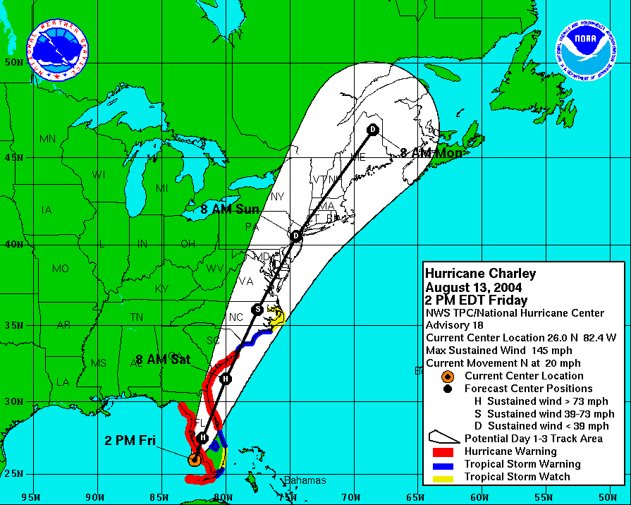
AT 11 AM EDT...1500Z...THE CENTER OF HURRICANE CHARLEY WAS LOCATED
NEAR LATITUDE 25.2 NORTH...LONGITUDE 82.8 WEST OR ABOUT 145 MILES
SOUTH OF SARASOTA FLORIDA.
CHARLEY IS MOVING TOWARD THE NORTH NEAR 18 MPH AND A TURN TOWARD THE
NORTH-NORTHEAST WITH AN INCREASE IN FORWARD SPEED IS EXPECTED
TODAY.
MAXIMUM SUSTAINED WINDS ARE NEAR 110 MPH...175 KM/HR...WITH HIGHER
GUSTS. SOME STRENGTHENING IS POSSIBLE PRIOR TO LANDFALL ON THE
FLORIDA WEST COAST THIS AFTERNOON OR EVENING.
HURRICANE FORCE WINDS EXTEND OUTWARD UP TO 30 MILES... 45 KM...
FROM THE CENTER...AND TROPICAL STORM FORCE WINDS EXTEND OUTWARD UP
TO 105 MILES...165 KM.
ESTIMATED MINIMUM CENTRAL PRESSURE IS 965 MB...28.49 INCHES.
STORM SURGE FLOODING IN THE FLORIDA KEYS WILL BE SUBSIDING LATER
TODAY. STORM SURGE FLOODING OF 10 TO 13 FEET IS EXPECTED NEAR AND
SOUTH OF THE WHERE THE CENTER CROSSES THE FLORIDA WEST COAST.
STORM SURGE FLOODING OF 4 TO 7 FEET ALONG AND NEAR THE GEORGIA
COAST IN THE NEXT 24 HOURS WITH LESSER FLOODING TO THE NORTH AND
SOUTH.
RAINFALL TOTALS OF 4 TO 8 INCHES ARE LIKELY ALONG CHARLEYS PATH
ACROSS THE EASTERN UNITED STATES. THESE RAINS COULD CAUSE
LIFE-THREATENING FLASH FLOODS.
ISOLATED TORNADOES ARE POSSIBLE ACROSS PARTS OF SOUTHERN AND CENTRAL
FLORIDA INCLUDING THE FLORIDA KEYS TODAY.
REPEATING THE 11 AM EDT POSITION...25.2 N... 82.8 W. MOVEMENT
TOWARD...NORTH NEAR 18 MPH. MAXIMUM SUSTAINED
WINDS...110 MPH. MINIMUM CENTRAL PRESSURE... 965 MB.
FOR STORM INFORMATION SPECIFIC TO YOUR AREA...PLEASE MONITOR
PRODUCTS ISSUED BY YOUR LOCAL WEATHER OFFICE.
INTERMEDIATE ADVISORIES WILL BE ISSUED BY THE NATIONAL
HURRICANE CENTER AT 1 PM EDT AND 3 PM EDT FOLLOWED
BY THE NEXT COMPLETE ADVISORY AT 5 PM EDT.
FORECASTER LAWRENCE
Code: Select all
BULLETIN
HURRICANE CHARLEY INTERMEDIATE ADVISORY NUMBER  17A
NWS TPC/NATIONAL HURRICANE CENTER MIAMI FL
1 PM EDT FRI AUG 13 2004

...CHARLEY STRENGTHENS AS IT HEADS TOWARD FLORIDA WEST COAST...

A HURRICANE WARNING REMAINS IN EFFECT FOR THE FLORIDA KEYS FROM THE
DRY TORTUGAS TO THE SEVEN MILE BRIDGE...AND FOR THE FLORIDA WEST
COAST FROM EAST CAPE SABLE NORTHWARD TO THE STEINHATCHEE RIVER. A
HURRICANE WARNING MEANS THAT HURRICANE CONDITIONS ARE EXPECTED
WITHIN THE WARNING AREA DURING THE NEXT 24 HOURS. PREPARATIONS
SHOULD BE RUSHED TO COMPLETION.

THE TROPICAL STORM WARNING FOR THE FLORIDA AND GEORGIA COASTS WERE
RECENTLY EXTENDED SOUTHWARD TO JUPITER INLET FLORIDA AND ARE NOW IN
EFFECT FROM THE SOUTH SANTEE RIVER SOUTH CAROLINA TO JUPITER INLET.
A  TROPICAL STORM WARNING REMAINS IN EFFECT FOR THE FLORIDA KEYS
FROM THE SEVEN MILE BRIDGE TO OCEAN REEF...AND ALONG THE SOUTH
FLORIDA MAINLAND FROM OCEAN REEF TO EAST CAPE SABLE...INCLUDING
FLORIDA BAY AND LAKE OKEECHOBEE.

A HURRICANE WATCH REMAINS IN EFFECT FROM FLAGLER BEACH FLORIDA
NORTHWARD TO THE SAVANNAH RIVER NEAR THE GEORGIA/SOUTH CAROLINA
BORDER.

A TROPICAL STORM WATCH REMAINS IN EFFECT FOR THE SOUTHEASTERN U.S.
COAST FROM OCEAN REEF NORTHWARD TO SOUTH OF COCOA BEACH AND FROM
THE SOUTH SANTEE RIVER NORTHWARD TO OREGON INLET NORTH CAROLINA
INCLUDING PAMLICO SOUND.

AT 1 PM EDT...1700Z...THE CENTER OF HURRICANE CHARLEY WAS LOCATED
NEAR LATITUDE 25.7 NORTH...LONGITUDE  82.5 WEST OR ABOUT  70 MILES
SOUTH-SOUTHWEST OF FORT MYERS FLORIDA.

CHARLEY IS NOW MOVING TOWARD THE NORTH-NORTHEAST NEAR 20 MPH AND
THIS MOTION IS EXPECTED TO CONTINUE TODAY WITH AN INCREASE IN
FORWARD SPEED.  ON THIS TRACK...THE CENTER OF THE HURRICANE SHOULD
REACH THE COAST IN THE VICINITY OF CHARLOTTE HARBOR LATER THIS
AFTERNOON.

RECENT REPORTS FROM A RECONNAISSANCE AIRCRAFT INDICATE THAT THE
MAXIMUM SUSTAINED WINDS HAVE INCREASED TO NEAR 125 MPH...WITH
HIGHER GUSTS...CATEGORY THREE ON THE SAFFIR/SIMPSON HURRICANE
SCALE.  THESE STRONGEST WINDS ARE CONFINED TO A SMALL AREA WITHIN A
FEW MILES FROM CHARLEYS CENTER.

HURRICANE FORCE WINDS EXTEND OUTWARD UP TO  30 MILES... 45 KM...
FROM THE CENTER...AND TROPICAL STORM FORCE WINDS EXTEND OUTWARD UP
TO 105 MILES...165 KM.

ESTIMATED MINIMUM CENTRAL PRESSURE IS  964 MB...28.46 INCHES.

STORM SURGE FLOODING IN THE FLORIDA KEYS WILL BE SUBSIDING LATER
TODAY.  STORM SURGE FLOODING OF 10 TO 13 FEET IS EXPECTED NEAR AND
SOUTH OF THE WHERE THE CENTER CROSSES THE FLORIDA WEST COAST.
STORM SURGE FLOODING OF 4 TO 7 FEET ALONG AND NEAR THE GEORGIA
COAST IN THE NEXT 24 HOURS WITH LESSER FLOODING TO THE NORTH AND
SOUTH.

RAINFALL TOTALS OF 4 TO 8 INCHES ARE LIKELY ALONG CHARLEYS PATH
ACROSS THE EASTERN UNITED STATES.  THESE RAINS COULD CAUSE
LIFE-THREATENING FLASH FLOODS.

ISOLATED TORNADOES ARE POSSIBLE ACROSS PARTS OF SOUTHERN AND CENTRAL
FLORIDA INCLUDING THE FLORIDA KEYS TODAY.

REPEATING THE 1 PM EDT POSITION...25.7 N... 82.5 W.  MOVEMENT
TOWARD...NORTH-NORTHEAST NEAR 20 MPH.  MAXIMUM SUSTAINED
WINDS...125 MPH.  MINIMUM CENTRAL PRESSURE... 964 MB.

FOR STORM INFORMATION SPECIFIC TO YOUR AREA...PLEASE MONITOR
PRODUCTS ISSUED BY YOUR LOCAL WEATHER OFFICE.

AN INTERMEDIATE ADVISORY WILL BE ISSUED BY THE NATIONAL
HURRICANE CENTER AT 3 PM EDT FOLLOWED BY THE NEXT
COMPLETE ADVISORY AT 5 PM EDT.

FORECASTER LAWRENCE
0 likes
-
ColdFront77
-
Anonymous
True, they were under a Hurricane warning..... But anyone who chose to use their own judgement may have been unpleasantly surprised after 11am... Port Charlotte was on the edge of the "cone of uncertainty" at 11am... By 1PM they were in the middle... I was under a hurricane warning in Jax at 11pm and returned home despite this cuz I used my own judgement.... I saw we were safe
0 likes
-
ColdFront77
-
Anonymous
-
CharlieGirl
- Tropical Wave

- Posts: 5
- Joined: Sat Aug 14, 2004 4:07 pm
- Location: Bonita Springs, FL
From my perspective here in SW FL, despite what the NHC forecast track was, our local media and emergency management made it quite clear that we could take this hurricane. Evacuations began on Wednesday all along the coast and barrier islands, and were stepped up dramatically on Thursday. On Friday morning when they began broadcasting hurricane info non-stop, they were all but pleading for people to leave. Anyone who stayed in their homes were going to stay no matter what. We had the warning that Tampa did, you just didn't here about it in the national media.
I chalk this one up to inexperience and complacency of the residents. I bet no one around here stays around for the next one.
I chalk this one up to inexperience and complacency of the residents. I bet no one around here stays around for the next one.
0 likes
-
Trader Ron

- S2K Supporter
- Posts: 928
- Joined: Tue Jul 22, 2003 7:25 pm
- Location: Naples,Fl
- Contact:
A Hurricane Warning means.........You can expect Hurricane Conditions in the Warning area. ! People should not be FIXATED on a certain landfall.
You stay at your own peril.
One more thing. There should be FULL PAGE Ads telling people what a Hurricane Warning means. It's amazing how many people don't know a thing about Hurricanes, and the potential damage they can do.
You stay at your own peril.
One more thing. There should be FULL PAGE Ads telling people what a Hurricane Warning means. It's amazing how many people don't know a thing about Hurricanes, and the potential damage they can do.
0 likes
-
therock1811

- Category 5

- Posts: 5163
- Age: 40
- Joined: Thu May 15, 2003 2:15 pm
- Location: Kentucky
- Contact:
Nope the advisory had originally been scheduled to come out around 1pm ET...NOT 2pm...now can we PLEASE Stop the met bashing!?!?!?!?!?
Jekyhe32210 wrote:I voted no---Here are the statements from both 11AM and 1PM.....The NHC (our weather authority) apparently had a second thought around 1pm and issues a new advisory.
Last edited by therock1811 on Tue Aug 17, 2004 4:48 pm, edited 1 time in total.
0 likes
-
Trader Ron
- S2K Supporter
- Posts: 928
- Joined: Tue Jul 22, 2003 7:25 pm
- Location: Naples,Fl
- Contact:
A Couple of more things.
1. There hasn't been a landfalling Hurricane of this strength since Donna in 1960.
2. You have many people who are Midwesterners. I'm not picking on them, they are lovely people. I bet 80% have never been in a Hurricane.
3. This is what it says for a Cat 3 Hurricane (111-130) MOBILE HOMES DESTROYED. I don't know what the exact timeline was, but i believe Charley had winds of 110 MPH Thursday Night. Still time to seek shelter.
4. It comes down to educating people about the risks in a Hurricane. The NHC said time and time again, If you are in the Hurricane Warning area, to prepare and seek shelter!
0 likes
-
therock1811
- Category 5
- Posts: 5163
- Age: 40
- Joined: Thu May 15, 2003 2:15 pm
- Location: Kentucky
- Contact:

Who is online
Users browsing this forum: No registered users and 63 guests