Posted by:
Sep 3rd 2004, 07:44:02 am
Fig Tree News Team
South Bar reports that the Harbour Island has been continually pounded with wind and rain since last night at 9, and it looks as though the eye is going over Spanish Wells in a couple of hours.
There is no electricity but phones are presently working. The tide is going down so hopefully the surge will be less as the tide is down. The consensus to date is that Frances is not as bad a storm as Andrew but more in the line of Floyd.
**
James Cistern just reported a few minutes ago that they're right in the middle of the eye (7:50a) ... and Warren Miller of Hatchet Bay called in this morning just to commend the ZNS 1 coverage countrywide. He says that things got rough last night, but Hatchet Bay folks ** unlike Governor's Harbour or James Cistern [or Harbour Island, for that matter, where the Vic Hum was packed from 5:00p forward!] ** were staying inside and pretty well packed down for the storm -- so far so good.
The eye is over Central Eleuthera at this moment ... the general sentiment
of everyone calling in from the Out Islands this morning to discuss their
various situation ** flooding and high winds in Long Island, houses damaged
in San Salvador, electricity and Internet access and cable out in Abaco,
high winds in Cat Island ** is that of relief that things aren't worse.
God bless ...
Stay tuned ...
BAHAMA UPDATES: Center over Grand Bahama; 90-105 mph winds.
Moderator: S2k Moderators
Forum rules

The posts in this forum are NOT official forecasts and should not be used as such. They are just the opinion of the poster and may or may not be backed by sound meteorological data. They are NOT endorsed by any professional institution or STORM2K. For official information, please refer to products from the National Hurricane Center and National Weather Service.
-
Cyclone Runner

- Category 1

- Posts: 409
- Joined: Wed Aug 11, 2004 9:29 pm
- Location: Crows Nest, NSW, Australia
- Contact:
0 likes
-
Cyclone Runner
- Category 1
- Posts: 409
- Joined: Wed Aug 11, 2004 9:29 pm
- Location: Crows Nest, NSW, Australia
- Contact:
Exuma Report
From: "Scott Giacobbe" <giacobbs AT exuma.cms.southcom.mil>
Date: Fri, 3 Sep 2004 08:06:08 -0400
Well we are fine and are in coms with people across the Island this
morning...we faired well thru out the night...trees down and such but
well...will venture out shortly to check it out more after my
coffee..priorities you know...power on the Island was spotty and at present
is still out...we still are feeling the back side with winds around 40 mph
gusts as of 8 am....but like a hangover will only get better as the day
progresses...we did so well ourselves as we are inland...others on the North
side had much more than we did...Thanks for the web site it's the
best...Heart goes out to all Islands...we all will have our Islands back to
norm soon... We can produce water around the 10,000 gal per day so that's
what we will do is check all folks and make sure they have clean drinking
water...Connie
Scott Giacobbe
OPBAT Site Manager
George Town, Great Exuma
Bahamas
(242)336-2186 Office
(242)336-2187 Fax
(242)357-0951 Cell
0 likes

-
Cyclone Runner
- Category 1
- Posts: 409
- Joined: Wed Aug 11, 2004 9:29 pm
- Location: Crows Nest, NSW, Australia
- Contact:
Little Harbour Abaco
Talked to Bob Ball, C6ALD, Little Harbour. He is reporting barometer of 29.38 and falling, seas 6-8 feet, tides one foot above normal. He reports gusts (estimated) of 100 mph. No damage at this time.
Another amateur radio operator, KF4TRG/C6A, somewhere in the Abacos, reported at 0830, winds 69 degrees at 37 mph gusting to 50. Barometer 999.0 and falling. She reported measured winds at Tilloo Cay at 0810L of 77 mph, measured winds at Guana Cay, Fisher's Bay, at 0830L of 74 mph.
9:15 news
Name:
Chris Potter
Date Posted:
Sep 3, 04 - 9:15 AM
chrisp986@yahoo.com
Message:
Just spoke to Trevor Pyfrom. Phones are up for now in Governor's Harbour. But I have lost phone contact with my parents. Tony said the eye passed over Governors about an hour ago. Wind now picking up strongly from the South. No word yet on damage in the town. I'll pass it on if I hear more.
Best Wishes, Chris
0 likes
-
Cyclone Runner
- Category 1
- Posts: 409
- Joined: Wed Aug 11, 2004 9:29 pm
- Location: Crows Nest, NSW, Australia
- Contact:
Subject: Hurricane Frances 9:35am
Name:Alma Drummond
Date Posted:Sep 3, 04 - 6:41 AM
Email:adrum99@aol.com
Message: Just spoke with Ormie Moss in Gov. Harbour, who thinks the eye has past there and is near Harbour Island at this time. Winds still about 80 mph and howling. Expects them to continue for sometime since he heard Cat Island is still having high winds.
Also the Abaco Message Board has just crashed, could be due to storm or to too much traffic.
0 likes
-
Cyclone Runner
- Category 1
- Posts: 409
- Joined: Wed Aug 11, 2004 9:29 pm
- Location: Crows Nest, NSW, Australia
- Contact:
Posted by:
Sep 3rd 2004, 09:50:55 am
Goombayboy
Eye of Frances over Harbour Island at 9:30am. Eye lasted 90 min in Governers Harbour. Governers reported worse winds after eye. Some roofs on Harbour are damaged, many trees down so far
Posted by:
Sep 3rd 2004, 09:50:46 am
chapel
Robert Arthur notes "from the eye" at 9:30s EST:
Beach did "remarkably well" even the tiki huts at Coral Sands still up, and not too much erosion -- as far as they could tell from north of Pink Sands down to about Runaway Hill Club. Bayside, water up to top of the wall, and lapping over the street, but that's it now. Not over government dock.
In the village, vegetation damage is about the extent of it, for now. When the eye passes, westerly winds from the rest of this storm will complete the story. Phone and power lines still up, some sagging, but in good shape generally. Bracing now for the other half.....
Posted by:
Sep 3rd 2004, 09:37:13 am
Kif
Just spoke with Sheril Saunders. People are out walking around while the eye passes. Understand Cookie has sustained significant roof damage.
Posted by:
Sep 3rd 2004, 10:05:01 amchapel
Bahama Sharon posts:
On NBC at 7:25 this AM, Friday, Michael Higgs gave a telephone interview and reported that at the moment the winds were 75 mph. Some roofs are gone and trees down but he was fine and so were his golf carts. The roof was off of the pre school. The backside of the storm was just approaching. He wished the people of Florida well as Hurricane Frances heads our way.
0 likes
-
Cyclone Runner
- Category 1
- Posts: 409
- Joined: Wed Aug 11, 2004 9:29 pm
- Location: Crows Nest, NSW, Australia
- Contact:
Eleu Hurricane Update 10:30 a.m. Friday
Name: jb
Date Posted:Sep 3, 04 - 7:24 AM
Message:Cannot get hold of George Majors in Tarpum Bay, the Tarpum Bay Police Station, and Tim Bert Carey of Rock Sound, so I think the phones may be down there.
Byron Rolle of Governor's Harbour said the eye has passed, and the winds are stronger than before the eye. So, I guess, Governors and the area are not out of the woods, they have to face the back end of the hurricane.
Keep your fingers crossed.
jb
0 likes
-
Cyclone Runner
- Category 1
- Posts: 409
- Joined: Wed Aug 11, 2004 9:29 pm
- Location: Crows Nest, NSW, Australia
- Contact:
GoodGenes
Member
Heard from Dive Abaco, Marsh Harbour
Just received a call from Melinda and Keith (Rogers) of Dive Abaco. Their home is 6 mi north of Marsh Harbour. They have boarded up, have their 4 Potcakes, 6 rescued Potcake puppies, and 4 cats all inside with them and are getting a closet ready to climb into if the roof goes. I could hear the wind blowing while we were talking. Melinda said it is bringing back memories of Floyd. She asked me to give her an update on Frances as they were having trouble picking up info on their shortwave radio. I let her listen to The Weather Channel report from Abaco Beach Resort and told her I would call her with the 11:00 AM update from the Nat'l Hurricane Center. They know they will have these conditions at least until tonight. I told her from the IR satellite loop it appears they are now receiving the more intense winds and rain. She said the power went off last night at 0300 and came back on for a short time at 0600 so she was able to make tea and coffee. She called me on her land line and said the cell phone was also still operating. I hope I can get through to her at 1100. May all in this storm's path be safe.
Jean Brown
0 likes
-
Cyclone Runner
- Category 1
- Posts: 409
- Joined: Wed Aug 11, 2004 9:29 pm
- Location: Crows Nest, NSW, Australia
- Contact:
Ulitong Member
more news from Treasure Cay,
Just spoke to my husband on a satellite phone(11am). He is in my parent's house on the first canal, Brigantine Rd. Water is coming over the sea wall, small trees in the yard are down, wind is getting stronger, everything else as expected. At 10 am the batelco phone was still working, right now I'm not getting a connection anymore. I will pass on any further messages from him. Thanks to all the good people out there who try to keep us in touch!
AbacoChris
Member
115 MPH gust at Little Harbour
Just hear a report from NHC of a wind gust at Little Harbour of 115.
Last edited by Cyclone Runner on Fri Sep 03, 2004 11:13 am, edited 1 time in total.
0 likes
-
Cyclone Runner
- Category 1
- Posts: 409
- Joined: Wed Aug 11, 2004 9:29 pm
- Location: Crows Nest, NSW, Australia
- Contact:
Subject:Had contact via phone
Name:Ken
Date Posted:Sep 3, 04 - 8:34 AM
Email:kholtermann@sprintmail.com
Name:Ken
Date Posted:Sep 3, 04 - 8:34 AM
Email:kholtermann@sprintmail.com
Message:Just spoke to friends over on Banana Beach and they said they had minor damage with some water in the house from the blowing but all were safe also the house next door had shingle damage .
They also told me that they were in contact with a friend over on Ten Bay and that the winds on ten bay were not to bad at that point but they had some minor roof and screen damage.
Subject:Harbour Island/North Eleuthera [Noon]
Name:Kimberly
Date Posted:Sep 3, 04 - 8:41 AM
Email:info@briland.com
Instant Messenger: coconutH2O
Message:At about 11:30a EST, the backside of the storm winds started to kick in off Harbour Island and North Eleuthera, which means that local news may be somewhat minimal over the next several hours.
Thanks for your patience. As information becomes available, we'll be in touch. In the meantime, check for ZNS Radio, streaming live at http://www.dabahamianting.com.
Kimberly
0 likes
-
Cyclone Runner
- Category 1
- Posts: 409
- Joined: Wed Aug 11, 2004 9:29 pm
- Location: Crows Nest, NSW, Australia
- Contact:
ulitong
More satellite phone news from Treasure Cay, Abaco
My husband just now called me again on the sat.phone. Winds are up to 100 mph now. Seawater has come above the canal and our lawn is submerged approx. 3 feet in. As this is high tide we're hoping it won't get much worse. He doesn't know of how things look anywhere else. Will keep everyone informed as soon as I hear more. He said that Mother Nature is really something else.... watched his boat bouncing up and down on the trailer inspite of being tied down etc. Let's keep hoping and praying for the best.
Subject:Rainbow Bay / James Cistern / Hatchet Bay Eleuthera
Name:Kristel
Date Posted:Sep 3, 04 - 12:19 AM
Email:kristelsea@yahoo.com
Instant Messenger:kristelc
Message: Talked to a friend in Rainbow just now (12:15) she ventured out during the eye (around 8am) and all looked good around her house (she's up on the hill top in the center of Rainbow). No shingles gone on her house - just some gutters missing. Paolo and Manon (Flipper) of Dolcevita (Rainbow Inn) are staying with her...they drove over to the Inn and all looks good so far there too. They're now getting hit by the 2nd half of the storm, and this is coming off the sea... Will check in again around 6pm.
Kristel
Subject:FRANCES Governor's Harbour, Eleuthera
Name:FGF
Date Posted:Sep 3, 04 - 12:45 AM
Email:BOATINA@AOL.COM
Message:Just spoke with Edgar Gardiner in Go. Harb. He said winds currently 120mph as they wait out the back half of the storm. Rain has benn minimal in the Harbour. Winds of 90mph were recorded last evening during the first half of Frances. No known damage or injuries. Power out last evening -still out - and land phones out this AM
0 likes
-
Cyclone Runner
- Category 1
- Posts: 409
- Joined: Wed Aug 11, 2004 9:29 pm
- Location: Crows Nest, NSW, Australia
- Contact:
Harbour Island, Bahamas [1:00p EST]
From: Kimberly King-Burns <kkingburns AT convergenz.com>
Date: Fri, 03 Sep 2004 09:54:59 -0700
Fisherman Randall Johnson reports from Girls Bank, Harbour Island:
Many trees sustained damage. Roof damage throughout the island was
reported, with maximum damage to the beach, as a lot of sand was reported
to be washed out. Phones are still up. Not as bad as Andrew and Floyd at
all. The back part of the storm is going over the island at a reported
35mph to 40mph. Boats are still intact and on land. There is a lot of
debris reported throughout the island, leaves off trees and trees
uprooted. The tide was out at the storm’s height thanks to the moon, so
not much in the way of flooding.
The Briland Modem
<www.briland.com>
Subject: Eleuthera Hurricane Update: 1:00 p.m. Friday
Name:jb
Date Posted:Sep 3, 04 - 9:58 AM
Message: Spotty phone service; got through to north of Governors Harbour near Workers House to Byron Rolle; he says winds still high past few hours, with roof damage evident from where he can see, with shingles flying, etc.
Looking at the high wind graphic at
http://www.nhc.noaa.gov/ftp/graphics/AT ... 12103P.gif
as judging from the speed of the hurricane at 10 mph, looks like the midportion of the island will have at least 5 to 10 hours more of high winds.
0 likes
-
Cyclone Runner
- Category 1
- Posts: 409
- Joined: Wed Aug 11, 2004 9:29 pm
- Location: Crows Nest, NSW, Australia
- Contact:
Situation Report #2 - Hurricane Frances
From: CDERA Information Unit <pubinfo AT cdera.org>
Date: Fri, 3 Sep 2004 17:34:20 GMT
ISSUED BY: Caribbean Disaster Emergency Response Agency (CDERA)
DATE: September 3, 2004
TIME: 11:00 AM
= = = = = = = = = = = = = = = = = = = = = = = = = = = = = = = =
The Event: At 11:00am Eastern Caribbean Time Hurricane Frances was located in
the Northwestern Bahamas very close to the island of Eleuthera with maximum
sustained winds of 115mph. It is forecast to approach the northernmost islands
in the Bahamas where Hurricane Warnings are still in effect.
The Prognosis: Hurricane Frances forward speed has slowed to near 9mph. This is
resulting in longer periods of hurricane force sustained conditions in the
islands of the Central Bahamas. Rainfall amounts are also increasing.
Status of RRM: The Regional Response Mechanism is activated. Caribbean Disaster
Relief Unit (CDRU) on Standby
The Situation – THE BAHAMAS
Reports early this morning from contacts within the National Emergency
Management Agency (NEMA), USAID/OFDA, PAHO, a Florida State University team,
deployed in The Bahamas, and HAM radio operators indicate that conditions are
improving in the Southeastern Bahamas. Only minor wind damage was reported and
no significant flooding.
Many shelters are open and operational as residents heeded the advice to seek
safety.
Damage Assessment is underway in most of the islands where the weather
condition has improved.
USAID/OFDA has finalized standby arrangements with the Government of The
Bahamas for an immediate flight after the all clear which will accommodate the
Prime Minister, US Ambassador, OFDA, NEMA, CDERA and PAHO to gain first hand
information on the scope and extent of any damages to the territory.
A second flight is also on standby to accommodate damage assessment teams and
transport supplies as necessary.
The International Federation of the Red Cross & Red Crescent Societies (IFRC)
has dispatched two disaster management specialists from their Pan American
Disaster Response Unit (PADRU) to Nassau to assist the local Red Cross
officials in shelter management. Other response personnel have been placed on
standby for deployment.
Actions By Coordinating Unit:
1. Ms. Audrey Mullings, Deputy Coordinator, CDERA, is in Jamaica to lead
the regional initial assessment team to The Bahamas on Saturday, if required.
2. Air Jamaica Express has graciously offered to transport 25 persons from
Jamaica to the Bahamas free of cost if required. This facility will be used to
transport the CDRU if it is required to deploy. The CDERA Coordinating Unit has
conveyed its thanks and appreciation on behalf of the region to Air Jamaica for
“its unhesitating readiness to support the Regional Response System”
3. The CDERA CU continues to issue SITREPS and News Releases on Hurricane
Frances which may be viewed at http://www.cdera.org. The UN/OCHA Reliefweb service is
also posting SITREPS at http://www.reliefweb.int
FURTHER INFORMATION CONTACT:
Mr Jeremy Collymore
Coordinator, CDERA
Tel: (246) 425-0386
0 likes
-
Cyclone Runner
- Category 1
- Posts: 409
- Joined: Wed Aug 11, 2004 9:29 pm
- Location: Crows Nest, NSW, Australia
- Contact:
Subject: Eleuthera Hurricane Update: 2:00 p.m. Friday
Name: jb
Date Posted:Sep 3, 04 - 11:21 AM
Message:It is difficult to get news of different parts of the island, unless you speak to people directly, because no-one is out and around inspecting the island, with winds of 100 to 120 mph lashing about.
Assessments of various parts of the island, including Current, Gregory Town, James Cistern Governors North Palmetto Point, TArpm Bay, Rock Sound most likely will not be done until the winds have died down, which will occur at around 7 or 8 tonight, if it occurs at all.
Most likely the roads will be blocked, and people that want to inspect damage will be severely hampered.
But we welcome posts of any news in any area, just hold tight, until the winds have died down for us to gather it in this central forum.
No reason to post updates from Weather channel, because the hurricane is there, with heavy winds, etc.
The Hurricane has, and is hitting Eleuthera.
It is simply a case of wind and water causing damage, and we will see how much after it is over.
jb
Last edited by Cyclone Runner on Fri Sep 03, 2004 1:49 pm, edited 1 time in total.
0 likes
-
Cyclone Runner
- Category 1
- Posts: 409
- Joined: Wed Aug 11, 2004 9:29 pm
- Location: Crows Nest, NSW, Australia
- Contact:
Exuma Update
From: "Scott Giacobbe" <giacobbs AT exuma.cms.southcom.mil>
Date: Fri, 3 Sep 2004 14:47:06 -0400
Just a little update on Exuma...Went looking at the damage and for any
people needing help....Looks like minor damage Island wide Shingles, trees,
and such...We are very lucky...Most folks have power and phones... Four
Seasons has trees down as well...Didn't go to Rolleville or further up
Island nor over to Little Exuma but did speak to friends on Little Exuma and
they are without power but have phones....Southside of the Island has lots
of swells because the winds are blowing 17 gusting to 29...but we checked on
a friends house on the Southside and all is well....Good luck Nassau.
Connie
Scott Giacobbe
OPBAT Site Manager
George Town, Great Exuma
Bahamas
(242)336-2186 Office
(242)336-2187 Fax
(242)357-0951 Cell
0 likes
-
Cyclone Runner
- Category 1
- Posts: 409
- Joined: Wed Aug 11, 2004 9:29 pm
- Location: Crows Nest, NSW, Australia
- Contact:
FIRST STORM-RELATED DEATH CONFIRMED
NASSAU UPDATE FRIDAY 2:45 PM
From: stolidref <stolidref AT yahoo.fr>
Date: Fri, 3 Sep 2004 20:46:22 +0200 (CEST)
Hi all!
Well it seems the worst is passed now. Winds currently at approx. 50 mph, with gusts at 60-70. We don't exactly know if the wind should now calm or pick up again. Everyone still needs to stay in the shelters.
We expect heavy rains later today. Last night, at 2:30 AM, we had to evacuate our rooms in the Radisson hotel Cable Beahc, as a measure of precaution. Have been in the hotel ballroom since.
Some tree damages; report of 1 death: an 18-year-old boy who got electrocuted while trying to start a generator.
Things should get better during the night.
Will keep you updated tomorrow.
Take care, hope everybody else has been safe.
Stolidref
0 likes
-
Cyclone Runner
- Category 1
- Posts: 409
- Joined: Wed Aug 11, 2004 9:29 pm
- Location: Crows Nest, NSW, Australia
- Contact:
Subject:Eleuthera Hurricane Update: 5:00 p.m. Friday
Name:jb
Date Posted:Sep 3, 04 - 2:13 PM
Message: Not much news, since communication with the island by telephone have been erased. Apparently, most of the island does not have phones, so please post if you have any way to communicate with the island.
Even the satellite phone in Tarpum Bay is not functional, although hopefully, that is temporary.
The last communication around 3 p.m. was that the winds had increased to between 100 and 120 mph, which apparently knocked out the phone lines.
High winds were expected to last until tonight.
No news of exact damage from this end.
jb
The NHC 8:00 PM advisory had a Ham operator communication from Hopetown as follows :
HURRICANE FORCE WINDS EXTEND OUTWARD UP TO 85 MILES...140 KM...
FROM THE CENTER...AND TROPICAL STORM FORCE WINDS EXTEND OUTWARD UP
TO 185 MILES...295 KM. DURING THE PAST HOUR...HAM RADIO OPERATORS AT
ABACO ISLAND REPORTED SUSTAINED WINDS OF 70 MPH WITH GUSTS TO 88 MPH
AT HOPETOWN...AND SUSTAINED WINDS OF 80 MPH AT LITTLE HARBOR. THE
SETTLEMENT POINT C-MAN STATION ON WESTERN GRAND BAHAMA ISLAND
RECENTLY REPORTED A SUSTAINED WIND OF 52 MPH WITH A GUST TO 62 MPH
...AND A GUST TO 45 MPH WAS REPORTED AT THE LAKE WORTH FLORIDA
C-MAN STATION.The NHC 8:00 PM advisory had a Ham operator communication from Hopetown as follows:
HURRICANE FORCE WINDS EXTEND OUTWARD UP TO 85 MILES...140 KM...
FROM THE CENTER...AND TROPICAL STORM FORCE WINDS EXTEND OUTWARD UP
TO 185 MILES...295 KM. DURING THE PAST HOUR...HAM RADIO OPERATORS AT
ABACO ISLAND REPORTED SUSTAINED WINDS OF 70 MPH WITH GUSTS TO 88 MPH
AT HOPETOWN...AND SUSTAINED WINDS OF 80 MPH AT LITTLE HARBOR. THE
SETTLEMENT POINT C-MAN STATION ON WESTERN GRAND BAHAMA ISLAND
RECENTLY REPORTED A SUSTAINED WIND OF 52 MPH WITH A GUST TO 62 MPH
...AND A GUST TO 45 MPH WAS REPORTED AT THE LAKE WORTH FLORIDA
C-MAN STATION.
Sep 3rd 2004, 08:03:39 pm
Ben K
Hi all.
It seems that although the (landline) phones on Harbour Island are working (have dialtone), it doesn't seem to be possible to dial off the island.
Also incoming calls don't seem to be getting through either, with callers getting 'all circuits busy' messages, busy tones or various other signals.
At the moment (7pm) there are still lots of strong gusts and squalls of rain... much like its been all afternoon. The sea is still very rough (on the east side).
Regards,
Ben
0 likes
-
Cyclone Runner
- Category 1
- Posts: 409
- Joined: Wed Aug 11, 2004 9:29 pm
- Location: Crows Nest, NSW, Australia
- Contact:
One dead as Hurricane Frances moves through The Bahamas
From: CDERA Information Unit <pubinfo AT cdera.org>
Date: Fri, 3 Sep 2004 22:44:30 GMT
SITUATION REPORT #3 - Hurricane Frances
ISSUED BY: Caribbean Disaster Emergency Response Agency
DATE: September 3, 2004
TIME: 6;00 pm
The Event: At 5:00pm Eastern Caribbean Time Hurricane Frances was approximately
90 miles East southeast of Freeport, Grand Bahama. . The north western Bahamas
continues to be under a Hurricane Warning as Frances slowly travels west
northwestward.
The Prognosis: Frances has been affecting the central and north western Bahamas
for the past 24 hours and is not expected to clear the area for another 24
hours. The Central Bahamas will gradually clear this evening into tonight as
the hurricane warning for that area has been discontinued by the National
Hurricane Centre.
Status of RRM: The Regional Response Mechanism is activated. Caribbean Disaster
Relief Unit (CDRU) on Standby
The Situation - BAHAMAS
***********************
Several islands of The Bahamas are still experiencing hurricane force and
tropical storm force winds at 5:00 pm.
Nassau – one person is confirmed dead. An 18-year old was outside in the height
of the hurricane attempting to service a standby generator and was
electrocuted. Roof of shelter at Bethsheda United Missionary Baptist Church
caved in. People safely moved to neighbours.
San Salvador – Hurricane Frances battered this island with 140 mph winds for 30
hours. 15 to 20 per cent of the housing stock has been damaged. Population is
1,000 people. Widespread environmental damage with fallen trees, power lines
and utility poles – much of which was cleared for initial damage assessment.
Health care facility is in good condition. A doctor, nurse, and official of the
Bahamian Defence Force were pre-positioned and are assisting residents. All
tourists at Club Med were evacuated and the hotel, which is empty, sustained
roofing damage.
New Providence is the headquarters of the Emergency Operations Centre of the
National Emergency Management Agency (NEMA) - At 5 pm tropical storm force
conditions were still affecting the island and expect to subside tomorrow.
Initial reports of environmental damage and storm surge affecting coastal areas
and cutting off coastal roads. Some homes have been flooded but assessment is
difficult this evening.
Acklins Island – Sustained damage to a marine docking facility and other
coastal damage from battering waves.
Acklins/Crooked Island/Long Cay - No major damage. Two Haitian boat people
detained.
Eleuthera – Winds in excess of 100 mph affected the island. Storm force
conditions still affecting the island. Power is out.
Harbour – Power out after island affected with winds in excess of 100 mph.
Storm surge and inland flooding reported. All evacuation shelters are occupied.
No reports of injury or death. Roads are impassable. Minor damage to health
clinic roof.
Inagua - Two vessels damaged.
Mayaguana – Road infrastructure damage. No loss of life. Power should be
restored by tonight or tomorrow morning.
Long Island – No damage
Exuma - Weather conditions improving. Water supplies restored.
Black Point – Telecommunications down.
Farmer’s Cay – Telecommunications down.
North Eleuthera - Winds reported in excess of 100 mph. Power out. Fibre optic
cable from North and South Eleuthera broken– no land-based contact with Spanish
Wells.
Central Eleuthera – No electricity and telecommunications down. No contact with
the island.
South Eleuthera – Tropical storm force conditions still exist. Damage
assessment not possible at this time.
North Andros – Tropical storm force conditions still exist. One property
reported damaged. Full assessment not possible at this time.
Central Andros – No known damage. Weather conditions mild.
South Andros / Mangrove Cay – No reported problems
Nassau International Airport - Heavy winds. Bahamasair Holdings Office roof
and front portion was torn off making it accessible to the public. Airport
Security is stationed at the site.
Berry Islands – Heavy rains continuing. Assessment not possible at this time.
Abaco – Winds becoming strong. 250 persons in public shelters.
East Grand Bahama – Winds becoming stronger. About 130 persons in public
shelters.
West Grand Bahama – Weather is good. 240 persons in public shelters.
Freeport Grand Bahama - Winds are picking up, continues to rain. 700 persons
in public shelters.
Ragged Island – No reported damage to any critical infrastructure.
Bimini / Cat Cay - Winds 35-40 mph. Four shelters are operational. No
significant damage, some fallen tree limbs.
ACTIONS BY COORDINATING UNIT
****************************
1. Ms. Audrey Mullings, Deputy Coordinator, CDERA, is coordinating
reconnaissance from Jamaica to The Bahamas in the morning. Estimates are that
weather conditions will permit flight travel by 7 am Saturday.
2. A Caribbean Media Corporation team will be part of the CDERA
reconnaissance and provide pool reports for the Caribbean media;
3. Another flight, coordinated by USAID/OFDA leaves Jamaica to transport
the Prime Minister of The Bahamas and a Government delegation to survey the
affected areas;
4. The CDRU is on standby for deployment to assist the Government of the
Bahamas. Air Jamaica Express has graciously offered to transport 25 persons
from Jamaica to the Bahamas free of cost if required. This facility will be
used to transport the CDRU if it is required to deploy. The CDERA CU has
conveyed its thanks and appreciation on behalf of the region to Air Jamaica for
“its unhesitating readiness to support the Regional Response System”
2. The CDERA CU continues to issue advisories/sitreps on Hurricane Frances
which may be viewed at http://www.cdera.org. The UN/OCHA Reliefweb service is also
posting SITREPS at http://www.reliefweb.int
FURTHER INFORMATION CONTACT:
Mr Jeremy Collymore
Coordinator, CDERA
Tel: (246) 425-0386
Mr Donovan Gentles
Preparedness and Response Manager, CDERA
Tel: (246) 425-0386
Mr Terry Ally
Public Education and Information Specialist, CDERA
Tel: (246) 425-0386
Mr Carl Smith
Director, National Emergency Management Agency, The Bahamas
Tel: (242) 322-2805
0 likes
-
Cyclone Runner
- Category 1
- Posts: 409
- Joined: Wed Aug 11, 2004 9:29 pm
- Location: Crows Nest, NSW, Australia
- Contact:
AFTERNOON AND EVENING UPDATE SEPTEMBER 03 2004
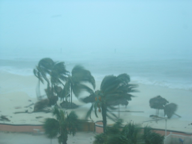
Photo from Nassau Area, September 3, 2004
Photo from Nassau Area, September 3, 2004
Posted by:
Sep 3rd 2004, 05:08:07 pm
chapel
It's official:
AT 5 PM EDT...2100Z...THE HURRICANE WARNING FOR THE CENTRAL BAHAMAS HAS BEEN DISCONTINUED.
We made it!!!!!!!
General Harbour Island Summary
Sep 3rd 2004, 11:25:46 pm
Otis-J
My name is Otis Johnson and I am relaying this information on behalf of my father, Randall Johnson. I spoke to him by phone at 11:31am, September 3rd, 2004.
Here it is:
- Trees are down and many of them are stripped of their leaves and branches.
- Debris is all over the island, consisting mainly of foliage, wood and roof materials.
- Electricity and cable is off and some of the power and cable lines are down (phones were working as of 11:31am).
- Major soil erosion at the beach. Some of the cabanas are still standing but the soil erosion is most noticeable.
-Hurricane Frances hit the island during low tide so the surge was not as bad, compared to other Hurricanes such as Andrew and Floyd.
- There are damages to the sea-wall on the harbour side.
-The government dock is in good condition mainly because of the low tide, which helped to keep the surge down.
-Boats that are on the land are still in tact.
- The full brunt of the storm hit in the early morning hours. Maximum wind gusts were reported at 5:30am to 6:30am. Wind gushes were between 110mph to 120mph.
- The eye came over the island at about 9:00am.
- Most importantly, everybody who is on the island is in good condition and there are no reports of fatalities and injuries.
Additionally, I did not receive any specific information about the condition of private docks, winter homes and government buildings.
0 likes
Who is online
Users browsing this forum: Ulf and 151 guests