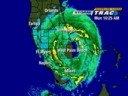
The latest surface obs looks like there is a surface low...This morning Ir shows that there is a well defined low level cirulation even so it is broad. It is moving across southern Florida. Which it should make its exit later this morning. This has become better oreganized over the last few hours. While most of the convection/rain and winds are to its north. A few convection burst has formed out ahead of it. That means that once it enters the Gulf it has a chance. But on the other side is that this is not really flaring up to fast. So it will take time. Models take it to the west making landfall in Texas around 72 hours. Models hint at it being a weak tropical storm. If it was upgraded as it went into the Gulf yes you could call it a naked swirl. But convection is likely to fire. But the southwestly shear noted coming from the southwest should keep this fairly weak.
Also to note there is finger banding forming on the southeastern side...This storm might try to do a Ericka.
http://weather.cod.edu/analysis/loops/s ... an&type=ir
Watch the system that is about ready to move into the Gulf!
Moderator: S2k Moderators
Forum rules

The posts in this forum are NOT official forecasts and should not be used as such. They are just the opinion of the poster and may or may not be backed by sound meteorological data. They are NOT endorsed by any professional institution or STORM2K. For official information, please refer to products from the National Hurricane Center and National Weather Service.


A lot of energy and rain in here if the shear will give it a chance.
http://radar.weather.gov/radar/loop/DS. ... kamx.shtml
http://radar.weather.gov/radar/loop/DS. ... kamx.shtml
0 likes
-
NativeFloridaGirl

- S2K Supporter

- Posts: 93
- Joined: Sun Aug 29, 2004 7:07 am
- Location: In Exile In Lower Alabama
-
charleston_hugo_veteran

- S2K Supporter
- Posts: 1590
- Joined: Thu Sep 04, 2003 12:47 pm
- Location: Charleston, S.C.
-
Ivanova
-
jlauderdal
- S2K Supporter
- Posts: 7240
- Joined: Wed May 19, 2004 5:46 am
- Location: NE Fort Lauderdale
- Contact:
Ivanova wrote:charleston_hugo_veteran wrote:
Local Met says it is expected to re-form in the gulf and that we need to keep an eye on it!
Yup... FOX news said the same thing...
FOX said Ivan may be regenerating
in the Gulf
*
fox said andrew is making a comeback too. the"center" came over my house last night and the winds went calm and the rain completely shutdown..i guess i can say i was in the center of ivan.
0 likes
-
Ivanova
-
Portastorm

- Storm2k Moderator

- Posts: 9946
- Age: 63
- Joined: Fri Jul 11, 2003 9:16 am
- Location: Round Rock, TX
- Contact:
I'm somewhat confused as to the eventual possibilities of this system. All of the morning forecast discussions by NWS forecasters in Texas and Louisiana call it either an inverted trough or tropical wave. None of them mention potential for tropical development, but NHC certainly does. And then there is JB who is honking for development and a possible intensification close to the Texas coast come Thursday night/Friday.
Yet, our Florida friends are reporting a great deal of rainfall and on satellite the system's scope has grown in the last 12 hours, which says to me "TROPICAL DEVELOPMENT POTENTIAL." I dunno what to think.

Yet, our Florida friends are reporting a great deal of rainfall and on satellite the system's scope has grown in the last 12 hours, which says to me "TROPICAL DEVELOPMENT POTENTIAL." I dunno what to think.
0 likes
Any forecasts under my name are to be taken with a grain of salt. Get your best forecasts from the National Weather Service and National Hurricane Center.
-
Ivanova
CocoaBill wrote:
look at the 'eye-like' center!
http://www.srh.noaa.gov/radar/loop/DS.p ... kbyx.shtml
All I know is that if Ivan reforms in the Gulf...
I heard it first here on Storm2K
this information is coming from the major media !
*
0 likes

-
Ivanova
-
DAVE440
- Tropical Storm

- Posts: 192
- Joined: Tue Sep 07, 2004 5:12 pm
- Location: Ft.Lauderdale Florida
- Contact:
QUOTE
I'm expecting to see animals walking by two by two any time now! We've had 7 inches of rain in the past 24 hours and it's still pouring.
FloridaGirl....any humptyback camels or chimpanzees on that boat? LOL!!
Actually... Looking at the different radars from this AM ....it appears the center is just exiting Naples. If you look carefully at the last few images there is a counterclockwise rotation almost wrapping around just below the word naples on the Nexrad radar loop (posted a reply or 2 up - which will change of course when someone clicks this link later on...but its there now).
BTW....with everyone referring to Ivan regenerating... just to clarify...this ISN'T IVAN and was Not part of the center of circulation. Ivans remnants didnt actually do a loop and come back to florida. This is just some atmospheric energy that was part of Ivans tail.
Last edited by DAVE440 on Tue Sep 21, 2004 6:47 am, edited 1 time in total.
0 likes
-
Ivanova
DAVE440 wrote:
QUOTE
BTW....with everyone referring to Ivan regenerating... just to clarify...this ISN'T IVAN and was Not part of the center of circulation. Ivans remnants didnt actually do a loop and come back to florida.
The met on CNN just now said Ivan DID do a loop
and this system in Florida IS part of Ivan !!
*
0 likes
Who is online
Users browsing this forum: Google [Bot], Ulf and 69 guests