000
URNT12 KNHC 250239
VORTEX DATA MESSAGE
A. 25/0239Z
B. 26 DEG 24 MIN N
74 DEG 51 MIN W
C. 850 MB 1088 M
D. NA
E. NA
F. 324 DEG 110 KT
G. 230 DEG 19 NM
H. 964 MB
I. 18 C/ 1533 M
J. 20 C/ 1544 M
K. 20 C/ NA
L. CLOSED WALL
M. C45
N. 12345/8
O. 0.1/1 NM
P. AF968 1911A JEANNE OB 08
MAX FL WIND 110 KT SW QUAD 0233Z.
MDT TURBC IN EYEWALL.
Jeanne Vortex 0239 UTC
Moderator: S2k Moderators
Forum rules

The posts in this forum are NOT official forecasts and should not be used as such. They are just the opinion of the poster and may or may not be backed by sound meteorological data. They are NOT endorsed by any professional institution or STORM2K. For official information, please refer to products from the National Hurricane Center and National Weather Service.
-
PurdueWx80
- Professional-Met

- Posts: 2720
- Joined: Fri Aug 13, 2004 8:33 pm
- Location: Madison, WI
- Contact:
Jeanne Vortex 0239 UTC
Last edited by PurdueWx80 on Fri Sep 24, 2004 10:31 pm, edited 1 time in total.
0 likes
-
Anonymous

-
PurdueWx80
- Professional-Met
- Posts: 2720
- Joined: Fri Aug 13, 2004 8:33 pm
- Location: Madison, WI
- Contact:

-
Derek Ortt

-
Derek Ortt

calidoug wrote:That's backwards alright.
If the flight-level winds are measured at a higher pressure = closer to the surface, you don't decrease them MORE to get surface winds, but less.
Nope.
Take a look at this wind profile from Hurricane Mitch.
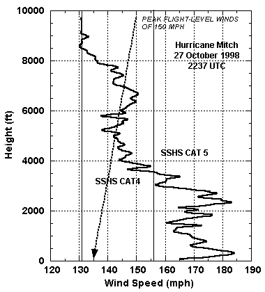
Notice how at the surface, his winds are 165 mph. Just above the surface, they increase to 185 mph.
Then notice how (taking out all the bumps), the wind slowly DECREASES with increasing height.
0 likes

HARDLY 26.5. Closer to 26.4...and that's at a time when the eye appeared to be moving north to some.
MW
MW
0 likes
Updating on the twitter now: http://www.twitter.com/@watkinstrack
-
Guest
000
URNT12 KNHC 250239
VORTEX DATA MESSAGE
A. 25/0239Z
B. 26 DEG 24 MIN N
74 DEG 51 MIN W
C. 850 MB 1088 M
D. NA
E. NA
F. 324 DEG 110 KT
G. 230 DEG 19 NM
H. 964 MB
I. 18 C/ 1533 M
J. 20 C/ 1544 M
K. 20 C/ NA
L. CLOSED WALL
M. C45
N. 12345/8
O. 0.1/1 NM
P. AF968 1911A JEANNE OB 08
MAX FL WIND 110 KT SW QUAD 0233Z.
MDT TURBC IN EYEWALL.
Isnt 26 DEG 24 suppose to be closer to 26.3 than 26.5
0 likes
redorangeglow wrote:000
URNT12 KNHC 250239
VORTEX DATA MESSAGE
A. 25/0239Z
B. 26 DEG 24 MIN N
74 DEG 51 MIN W
C. 850 MB 1088 M
D. NA
E. NA
F. 324 DEG 110 KT
G. 230 DEG 19 NM
H. 964 MB
I. 18 C/ 1533 M
J. 20 C/ 1544 M
K. 20 C/ NA
L. CLOSED WALL
M. C45
N. 12345/8
O. 0.1/1 NM
P. AF968 1911A JEANNE OB 08
MAX FL WIND 110 KT SW QUAD 0233Z.
MDT TURBC IN EYEWALL.
Isnt 26 DEG 24 suppose to be closer to 26.3 than 26.5
Not quite. Since there are 24 minutes in a degree to convert it to decimal it becomes 26 degrees and 24/60, or 26.40 degress N latitude.
0 likes
Who is online
Users browsing this forum: No registered users and 91 guests