It might be a good idea to sticky this topic please.
Please see the following two webpages:
http://www.accuweather.com/iwxpage/adc/ ... wx_115.htm
Maps:
http://wwwa.accuweather.com/adcbin/publ ... ype=winter
In short, AccuWeather is forecasting a colder than normal winter, with above normal snowfall for the eastern US.
I'm not sure what to think, but I will go buy a couple more square-edged, construction-grade shovels. It's possible I may need them.
-Jeb
AccuWeather Releases its 2004-2005 Winter Outlook
Moderator: S2k Moderators
Forum rules
 The posts in this forum are NOT official forecast and should not be used as such. They are just the opinion of the poster and may or may not be backed by sound meteorological data. They are NOT endorsed by any professional institution or STORM2K.

The posts in this forum are NOT official forecast and should not be used as such. They are just the opinion of the poster and may or may not be backed by sound meteorological data. They are NOT endorsed by any professional institution or STORM2K.
-
Anonymous
AccuWeather Releases its 2004-2005 Winter Outlook
Last edited by Anonymous on Mon Oct 25, 2004 7:26 pm, edited 1 time in total.
0 likes


-
Stormsfury

- Category 5

- Posts: 10549
- Age: 53
- Joined: Wed Feb 05, 2003 6:27 pm
- Location: Summerville, SC
In short, AccuWeather is forecasting a colder than normal winter, with above normal snowfall for the eastern US.
Sorry to be so blunt, but this is the story with Accuweather's winter forecast ... EVERY year ... so there's no surprise in that assessment ...
However, I don't have any reason to disagree at this time ... virtually all the long range ensemble forecasts for the 2004-2005 winter season are coming up with BLO normal temperatures for much of the east ...
SF
0 likes
-
wxguy25

- Professional-Met

- Posts: 708
- Joined: Wed Oct 13, 2004 4:44 pm
- Location: East Central Florida
- Contact:
Stormsfury wrote:In short, AccuWeather is forecasting a colder than normal winter, with above normal snowfall for the eastern US.
Sorry to be so blunt, but this is the story with Accuweather's winter forecast ... EVERY year ... so there's no surprise in that assessment ...
However, I don't have any reason to disagree at this time ... virtually all the long range ensemble forecasts for the 2004-2005 winter season are coming up with BLO normal temperatures for much of the east ...
SF
I agree with it too, They pretty much the Above and below normal anomalies in the same place as I do. Only Difference is I expect the above normal snowfall to cover a MUCH LARGER area of the EUS, with the core of the above normal snow over the Interior Mid Atlantic, Northeast and new England. Less toward the coast, but above normal nonetheless.
Yes there will be a few I-95 heartbreakers.
BTW...looking forward to your winter outlook, SF!
0 likes
-
Stormsfury
- Category 5
- Posts: 10549
- Age: 53
- Joined: Wed Feb 05, 2003 6:27 pm
- Location: Summerville, SC
BTW...looking forward to your winter outlook, SF!
yikes ... I haven't even begun to compile ideas except that I do believe the Southeast gets (at least) one significant winter storm this year, and I'm talking about a pretty far south runner ...
I'm looking into working on a compilation of landfalling TC's in the Southeast Region (particularly South Carolina) and a correlation to coastal snow/ice events on given years ...
Overall, a lot of ideas that have been laid out by don, yourself, and many others seems to me to be on track ... with cooler temperature anomalies across much of the East, and average to above average precip across the Southern Tier ... GOM activity (storm initiation in the GOM looks a little better than average this upcoming winter season) ...
SF
0 likes
-
wxguy25
- Professional-Met
- Posts: 708
- Joined: Wed Oct 13, 2004 4:44 pm
- Location: East Central Florida
- Contact:
Stormsfury wrote:BTW...looking forward to your winter outlook, SF!
yikes ... I haven't even begun to compile ideas except that I do believe the Southeast gets (at least) one significant winter storm this year, and I'm talking about a pretty far south runner ...
I'm looking into working on a compilation of landfalling TC's in the Southeast Region (particularly South Carolina) and a correlation to coastal snow/ice events on given years ...
Overall, a lot of ideas that have been laid out by don, yourself, and many others seems to me to be on track ... with cooler temperature anomalies across much of the East, and average to above average precip across the Southern Tier ... GOM activity (storm initiation in the GOM looks a little better than average this upcoming winter season) ...
SF
it's not just about the GOM season. Try looking at this season's Atlantic Activity in relationship to the East pacific activity, then after your done with that, drop the seasons that were la nina and neutral seasons, and look just at the El Nino years. once you have the El Nino years isolated dump the seasons where the PDO was in the long term warm phase and you should see something interesting in the h500 means for the following winter. Look over the North Atlantic.
0 likes
-
yoda

- Category 5
- Posts: 7874
- Joined: Tue Jan 13, 2004 3:51 pm
- Location: Springfield VA (20 mins south of DC)
- Contact:
wxguy25 wrote:Stormsfury wrote:BTW...looking forward to your winter outlook, SF!
yikes ... I haven't even begun to compile ideas except that I do believe the Southeast gets (at least) one significant winter storm this year, and I'm talking about a pretty far south runner ...
I'm looking into working on a compilation of landfalling TC's in the Southeast Region (particularly South Carolina) and a correlation to coastal snow/ice events on given years ...
Overall, a lot of ideas that have been laid out by don, yourself, and many others seems to me to be on track ... with cooler temperature anomalies across much of the East, and average to above average precip across the Southern Tier ... GOM activity (storm initiation in the GOM looks a little better than average this upcoming winter season) ...
SF
it's not just about the GOM season. Try looking at this season's Atlantic Activity in relationship to the East pacific activity, then after your done with that, drop the seasons that were la nina and neutral seasons, and look just at the El Nino years. once you have the El Nino years isolated dump the seasons where the PDO was in the long term warm phase and you should see something interesting in the h500 means for the following winter. Look over the North Atlantic.
Interesting. I had not thought of that. Thanks for bringing that up.
0 likes
-
Stormsfury
- Category 5
- Posts: 10549
- Age: 53
- Joined: Wed Feb 05, 2003 6:27 pm
- Location: Summerville, SC
for the GOM storm development during the winter this year, the enhanced SBJ chances should be able to spin up a few SFC lows, and since I expect the El Niño to NOT overwhelm other signals ... increased chances for CAD scenarios as well (heck, already stuck in one currently ... and it's been fairly prolonged with the numerous cutoff lows in the W ATL in recent weeks) ...
gotta get some sleep ... can barely hold my eyes open ...
progged to work 65 hours this week ...
gotta get some sleep ... can barely hold my eyes open ...
progged to work 65 hours this week ...
0 likes
-
yoda
- Category 5
- Posts: 7874
- Joined: Tue Jan 13, 2004 3:51 pm
- Location: Springfield VA (20 mins south of DC)
- Contact:
Stormsfury wrote:for the GOM storm development during the winter this year, the enhanced SBJ chances should be able to spin up a few SFC lows, and since I expect the El Niño to NOT overwhelm other signals ... increased chances for CAD scenarios as well (heck, already stuck in one currently ... and it's been fairly prolonged with the numerous cutoff lows in the W ATL in recent weeks) ...
gotta get some sleep ... can barely hold my eyes open ...
progged to work 65 hours this week ...
Agreed. The SBJ should help enhance surface circulation in the GOM. CAD should be good this winter...
Get some sleep SF... you deserve it!
0 likes
-
aggiecutter
- Category 5
- Posts: 1755
- Joined: Thu Oct 14, 2004 9:22 pm
- Location: Texarkana
What do you guys think about this NOA forcast. Voodoo science or does it have a leg to stand on.
http://forecast.mssl.ucl.ac.uk/
http://forecast.mssl.ucl.ac.uk/
0 likes
-
yoda
- Category 5
- Posts: 7874
- Joined: Tue Jan 13, 2004 3:51 pm
- Location: Springfield VA (20 mins south of DC)
- Contact:
aggiecutter wrote:What do you guys think about this NOA forcast. Voodoo science or does it have a leg to stand on.
http://forecast.mssl.ucl.ac.uk/
I agree. The NAO going negative is likely to happen. Wouldn't the PNA going positive agree with this? Or am I just putting things correctly incorrectly?
0 likes
-
wxguy25
- Professional-Met
- Posts: 708
- Joined: Wed Oct 13, 2004 4:44 pm
- Location: East Central Florida
- Contact:
Stormsfury wrote:for the GOM storm development during the winter this year, the enhanced SBJ chances should be able to spin up a few SFC lows, and since I expect the El Niño to NOT overwhelm other signals ... increased chances for CAD scenarios as well (heck, already stuck in one currently ... and it's been fairly prolonged with the numerous cutoff lows in the W ATL in recent weeks) ...
gotta get some sleep ... can barely hold my eyes open ...
progged to work 65 hours this week ...
As long as the NAO stays negative in the means, the East will not see the kind of warm-ups which the current pattern would signal regardless of whether the pattern over the pacific flips or not. Otherwise I pretty much agree with you.
0 likes
-
wxguy25
- Professional-Met
- Posts: 708
- Joined: Wed Oct 13, 2004 4:44 pm
- Location: East Central Florida
- Contact:
yoda wrote:aggiecutter wrote:What do you guys think about this NOA forcast. Voodoo science or does it have a leg to stand on.
http://forecast.mssl.ucl.ac.uk/
I agree. The NAO going negative is likely to happen. Wouldn't the PNA going positive agree with this? Or am I just putting things correctly incorrectly?
I agree also. everything that I have seen from the hurricane season, to the SSTA configuration in the atlantic plus what we have already seen w/ the NAO averaging strongly negative over the past few weeks is evidence enough for me to forecast it negative in my winter outlook.
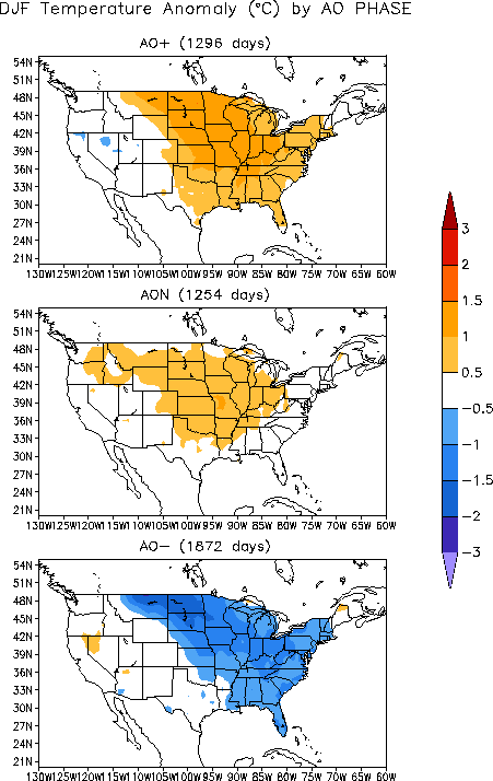
Im more concerned about the AO phase this winter with the east pacific signal in a state of transition. overall my guess would be neutral to slightly negative for the AO given the Atlantic set-up however it could be strongly negative if we can get that warm pool in the GOA. I suspect that was one of the driving forces behind the strong -AO phase during the OND 2002 period.
0 likes
-
wxguy25
- Professional-Met
- Posts: 708
- Joined: Wed Oct 13, 2004 4:44 pm
- Location: East Central Florida
- Contact:
Thanks
and for those who like time-height cross sections:
Notice during the JUL-AUG period the AO was mostly negative when we had the warm pool in the GOA. Once the pattern reversed in SEP the AO went positive and has been up and down since then. Until that signal becomes more clear cut the AO will display quite a bit of variability.
The GFS ensembles are forecasting it positive over the next 15 days. Strongly so actually as the PV sets up over the pole.
0 likes
Who is online
Users browsing this forum: No registered users and 245 guests