October QBO number is in ...

Winter Weather Discussion

Moderator: S2k Moderators

Forum rules

The posts in this forum are NOT official forecast and should not be used as such. They are just the opinion of the poster and may or may not be backed by sound meteorological data. They are NOT endorsed by any professional institution or STORM2K.

Help Support Storm2K
Message
Author
User avatar
Wnghs2007
Category 5
Category 5
Posts: 6836
Age: 36
Joined: Wed Mar 24, 2004 11:14 pm
Location: Gwinnett-Barrow Line; Georgia
Contact:

October QBO number is in ...

#1 Postby Wnghs2007 » Thu Nov 04, 2004 8:00 pm

RALIEGHWX on WRIGHT-WEATHER.com wrote:UP to 7.84 from 7.22 in September. This is big, because it shows that it is possible that we will see a very slow drop in value over the winter, and a chance we stay positive and dont see a phase change, or if we do it will be late winter, probably February or March. Also, new MEI data is supposed to come out today as well.


Interesting is it not
0 likes   

User avatar
wxguy25
Professional-Met
Professional-Met
Posts: 708
Joined: Wed Oct 13, 2004 4:44 pm
Location: East Central Florida
Contact:

Re: October QBO number is in ...

#2 Postby wxguy25 » Sat Nov 06, 2004 8:39 pm

Wnghs2007 wrote:
RALIEGHWX on WRIGHT-WEATHER.com wrote:UP to 7.84 from 7.22 in September. This is big, because it shows that it is possible that we will see a very slow drop in value over the winter, and a chance we stay positive and dont see a phase change, or if we do it will be late winter, probably February or March. Also, new MEI data is supposed to come out today as well.


Interesting is it not


It would mean that a majority of the winter will be dominated by El Nino/west QBO conditions. Assuming that the weak El Nino makes it through the first 1/2 of the winter. In 2002-03 the QBO went east in DEC but nonetheless failed to increase rapidly so it remained weak east through the winter. the weak QBO value may be critical b/c it could suggest a better chance for a big east coast snow event at some point in the winter.

As for other signals, the QBO and weak El Nino are really all we have going now as far as indicators for cold and snow in the east. the East pacific signal is the inverse of 1986-87, 1993-94 and 2002-03 which suggests a +EPO and strong pacific jet. with this kind of SSTA configuration over the North pacific its hard to get a persistent +PNA pattern so the reliance on a -NAO becomes more important in order to save the east.

http://www.osdpd.noaa.gov/PSB/EPS/SST/d ... .small.gif


All in all...both the Atlantic and Pacific signals are (IMO) weaker versions of 2001--and of course this year we have the El Nino which we didnt have then, and 2001-02 was a solar max winter.

http://www.osdpd.noaa.gov/PSB/EPS/SST/d ... 3.2001.gif
0 likes   

User avatar
yoda
Category 5
Category 5
Posts: 7874
Joined: Tue Jan 13, 2004 3:51 pm
Location: Springfield VA (20 mins south of DC)
Contact:

#3 Postby yoda » Sat Nov 06, 2004 8:42 pm

Excellent analysis Wxguy25. The QBO will need to be watched closely IMO as the winter progresses.
0 likes   

User avatar
wxguy25
Professional-Met
Professional-Met
Posts: 708
Joined: Wed Oct 13, 2004 4:44 pm
Location: East Central Florida
Contact:

#4 Postby wxguy25 » Sat Nov 06, 2004 8:49 pm

yoda wrote:Excellent analysis Wxguy25. The QBO will need to be watched closely IMO as the winter progresses.


Alot more than that needs to be watched. My winter outlook is in SERIOUS trouble if we have that setup in the EPAC a majority of the winter.
0 likes   

User avatar
yoda
Category 5
Category 5
Posts: 7874
Joined: Tue Jan 13, 2004 3:51 pm
Location: Springfield VA (20 mins south of DC)
Contact:

#5 Postby yoda » Sat Nov 06, 2004 9:35 pm

wxguy25 wrote:
yoda wrote:Excellent analysis Wxguy25. The QBO will need to be watched closely IMO as the winter progresses.


Alot more than that needs to be watched. My winter outlook is in SERIOUS trouble if we have that setup in the EPAC a majority of the winter.


Interesting. If that turns up, will that turn your forecast upside down?
0 likes   

User avatar
wxguy25
Professional-Met
Professional-Met
Posts: 708
Joined: Wed Oct 13, 2004 4:44 pm
Location: East Central Florida
Contact:

#6 Postby wxguy25 » Sat Nov 06, 2004 9:36 pm

yoda wrote:
wxguy25 wrote:
yoda wrote:Excellent analysis Wxguy25. The QBO will need to be watched closely IMO as the winter progresses.


Alot more than that needs to be watched. My winter outlook is in SERIOUS trouble if we have that setup in the EPAC a majority of the winter.


Interesting. If that turns up, will that turn your forecast upside down?


Were talking grilled like John Kerry. :wink:
0 likes   

User avatar
yoda
Category 5
Category 5
Posts: 7874
Joined: Tue Jan 13, 2004 3:51 pm
Location: Springfield VA (20 mins south of DC)
Contact:

#7 Postby yoda » Sat Nov 06, 2004 9:39 pm

wxguy25 wrote:
yoda wrote:
wxguy25 wrote:
yoda wrote:Excellent analysis Wxguy25. The QBO will need to be watched closely IMO as the winter progresses.


Alot more than that needs to be watched. My winter outlook is in SERIOUS trouble if we have that setup in the EPAC a majority of the winter.


Interesting. If that turns up, will that turn your forecast upside down?


Were talking grilled like John Kerry. :wink:


Ah ok.

Yeah, my forecast, although it is not finished and should have been a long time ago (because of problems I have) had included the QBO and the EPAC set up. I just recently looked at the MJO, which Dave showed on WWBB. How does the MJO play into winter?
0 likes   

User avatar
wxguy25
Professional-Met
Professional-Met
Posts: 708
Joined: Wed Oct 13, 2004 4:44 pm
Location: East Central Florida
Contact:

#8 Postby wxguy25 » Sat Nov 06, 2004 10:34 pm

The MJO impacts circulation patterns over the North pacific (blocking) and western North America...plus influences the pacific jet. Right now with the curent pulse arriving, its possible that a more winter like pattern sets in over Portions of north America for the end of NOV and a good deal of DEC which I accounted for in those graphics I posted awhile back concerning the pattern evolution for the Mid-Late part of NOV through Xmas.

The MJO plays just as important a role in the cold season as it does in the tropical season w/ hurricane formation.

AND the SOI is crashing so we should see a nice Kelvin wave push eastward and maybe warm things up a bit in the EQ pacific. the STJ will also get excited.

30-Oct-2004 1012.68 1009.25 3.40 -3.00 -4.33
31-Oct-2004 1010.70 1008.30 -3.10 -3.19 -4.29
1-Nov-2004 1010.97 1008.95 -5.40 -3.49 -4.35
2-Nov-2004 1010.80 1009.60 -10.60 -3.94 -4.45
3-Nov-2004 1010.24 1009.90 -16.10 -4.49 -4.51
4-Nov-2004 1008.56 1009.50 -24.30 -5.30 -4.61
5-Nov-2004 1007.36 1008.55 -25.90 -5.79 -4.88

But as long the North Pacific SSTA configuration is inverted, im not sure how long we can lock the east into a cold pattern. DEC 1963 was BRUTAL in the EUS, but JAN was less impressive.

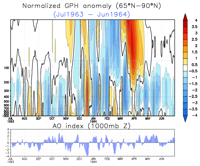
in DEC 1963 we had the return of the Aleutian low, significant high latitude blocking over the Arctic regions and North Atlantic (-AO/-NAO) which helped send the trouhg into the EUS.

DEC '63

JAN '64

As I said before, (and it's an important point, So I'll bring it up again) since the Tripole of anomalous heights associated w/ the AO have a center of opposite sign to the pole located over the North pacific, that SSTA configuration is critical, and one of the resons why the AO was extremely negative during OND 2002.

for a -AO you should have a negative height anomaly over the North pacific (strong Aleutian low)

the AO was in the tank in DEC 1963

http://www.cpc.ncep.noaa.gov/products/p ... o.1963.gif
0 likes   

User avatar
yoda
Category 5
Category 5
Posts: 7874
Joined: Tue Jan 13, 2004 3:51 pm
Location: Springfield VA (20 mins south of DC)
Contact:

#9 Postby yoda » Sat Nov 06, 2004 10:41 pm

Thanks for all the info and analysis. :D
0 likes   

User avatar
wxguy25
Professional-Met
Professional-Met
Posts: 708
Joined: Wed Oct 13, 2004 4:44 pm
Location: East Central Florida
Contact:

#10 Postby wxguy25 » Sat Nov 06, 2004 10:54 pm

yoda wrote:Thanks for all the info and analysis. :D


yeah, you bet. For the next few days, the pattern will be anchored by the cutoff low near the CA coast which is forcing the trough into the east.
0 likes   

User avatar
yoda
Category 5
Category 5
Posts: 7874
Joined: Tue Jan 13, 2004 3:51 pm
Location: Springfield VA (20 mins south of DC)
Contact:

#11 Postby yoda » Sat Nov 06, 2004 11:00 pm

wxguy25 wrote:
yoda wrote:Thanks for all the info and analysis. :D


yeah, you bet. For the next few days, the pattern will be anchored by the cutoff low near the CA coast which is forcing the trough into the east.


And since the trough is moving East, that means that we here in the East will see colder than normal temperatures for the next few days right?
0 likes   

User avatar
wxguy25
Professional-Met
Professional-Met
Posts: 708
Joined: Wed Oct 13, 2004 4:44 pm
Location: East Central Florida
Contact:

#12 Postby wxguy25 » Sat Nov 06, 2004 11:02 pm

yoda wrote:
wxguy25 wrote:
yoda wrote:Thanks for all the info and analysis. :D


yeah, you bet. For the next few days, the pattern will be anchored by the cutoff low near the CA coast which is forcing the trough into the east.


And since the trough is moving East, that means that we here in the East will see colder than normal temperatures for the next few days right?


We'll say no big warm-up over the next 7-10 days if the ECMWF is correct.
0 likes   

User avatar
yoda
Category 5
Category 5
Posts: 7874
Joined: Tue Jan 13, 2004 3:51 pm
Location: Springfield VA (20 mins south of DC)
Contact:

#13 Postby yoda » Sat Nov 06, 2004 11:25 pm

Yes I saw the ECMWF... I like it cause it brings some nice cold weather.
0 likes   


Return to “Winter Weather”

Who is online

Users browsing this forum: No registered users and 9 guests