The new snowcover data for September and October reinforces the early ideas concerning snowfall for Winter 2004-05 as outlined in my preliminary winter outlook. In addition, it increasingly appears that the NAO will be predominantly below zero this coming winter.
1) From the global approach I've been examining with regard to the NAO, I am increasingly confident that the NAO will average below 0 both for the December-February and longer December-March periods.
2) The North American and Northern Hemisphere snowcover seem to be evolving as one would expect for a snowy winter in Boston and possibly down to NYC.
Some years that come up with North American snowcover trends:
1993-94
1996-97
2000-01
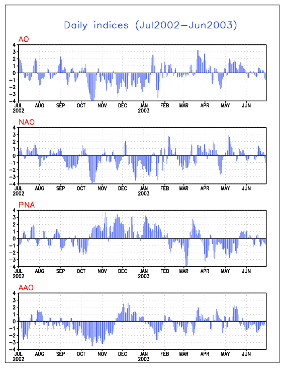
2002-03
2003-04
Some years that come up with Northern Hemisphere snowcover trends:
1993-94
1999-00
2001-02
2002-03
Common years:
1993-94
2002-03
Big clue: If November's Northern Hemisphere snowcover reaches 34 million square kilometers or more, one can throw out such winters as 1999-00 and 2001-02.
Ingredients for Winter 2004-05 Continue to Fall into Place
Moderator: S2k Moderators
Forum rules
 The posts in this forum are NOT official forecast and should not be used as such. They are just the opinion of the poster and may or may not be backed by sound meteorological data. They are NOT endorsed by any professional institution or STORM2K.

The posts in this forum are NOT official forecast and should not be used as such. They are just the opinion of the poster and may or may not be backed by sound meteorological data. They are NOT endorsed by any professional institution or STORM2K.
-
donsutherland1
- S2K Analyst

- Posts: 2718
- Joined: Mon Sep 15, 2003 8:49 pm
- Location: New York

What happened in 99-00 and 01-02? Did we not get a lot of snow or what? Basically I'm asking if the snowcover reaches 34 million square kilometers what will the winter be like? Also could you type back at the end of November to let us know how much it did reach or give us the website to see the graphics.
thanks
thanks
0 likes
-
donsutherland1
- S2K Analyst
- Posts: 2718
- Joined: Mon Sep 15, 2003 8:49 pm
- Location: New York
Greg81988,
Those were two very poor winters in the Mid-Atlantic and Northeast. Snowfall totals for select cities follow:
I strongly doubt that we'll see less than 34 million square kilometers of Northern Hemisphere snowcover by the end of November. A lot of additional data also points to far better winters than 1999-00 and 2001-02.
In any case, I will follow up with the November figure when it comes out (early December?) as it will be another milestone that indicates whether the overall winter ideas are on or off track.
Those were two very poor winters in the Mid-Atlantic and Northeast. Snowfall totals for select cities follow:
Code: Select all
Winter   Boston   NYC   Wash.
1999-00   24.9"   16.3"   15.4"
2001-02   15.1"    3.5"    3.2"
I strongly doubt that we'll see less than 34 million square kilometers of Northern Hemisphere snowcover by the end of November. A lot of additional data also points to far better winters than 1999-00 and 2001-02.
In any case, I will follow up with the November figure when it comes out (early December?) as it will be another milestone that indicates whether the overall winter ideas are on or off track.
0 likes
-
wxguy25

- Professional-Met

- Posts: 708
- Joined: Wed Oct 13, 2004 4:44 pm
- Location: East Central Florida
- Contact:
Don, GREAT posts as always. The OCT 2004 NH snowcover extent is the third greatest since 1973 behind only 1976, and 2002.
two points regarding that.
1. The Above normal snowcover should help to intensify the Siberian high and promote a mostly -AO over the next few months like we saw in 1976 and 2002.
http://www.cpc.ncep.noaa.gov/products/p ... o.1976.gif
2. You can already eliminate 1999-00 and 2001-02 b/c of the La nina in 1999-00 and 2001-02 was a solar maximum winter. Plus, since the middle of OCT there has been an unusually fast buildup of cold air over the pole.
Notice the -25 to -30 C air located along the Arctic coast of greenland in association w/ the PV.


As far as the NAO is concerned, all we have to do is look at the trend over the past month or so.
OCT 2004 has seen a strongly -NAO in the means for the month with plenty of blocking. this should be a sign of things to come for the next few months.
two points regarding that.
1. The Above normal snowcover should help to intensify the Siberian high and promote a mostly -AO over the next few months like we saw in 1976 and 2002.
http://www.cpc.ncep.noaa.gov/products/p ... o.1976.gif
2. You can already eliminate 1999-00 and 2001-02 b/c of the La nina in 1999-00 and 2001-02 was a solar maximum winter. Plus, since the middle of OCT there has been an unusually fast buildup of cold air over the pole.
Notice the -25 to -30 C air located along the Arctic coast of greenland in association w/ the PV.
As far as the NAO is concerned, all we have to do is look at the trend over the past month or so.
OCT 2004 has seen a strongly -NAO in the means for the month with plenty of blocking. this should be a sign of things to come for the next few months.
0 likes
-
Chris the Weather Man

- Category 2

- Posts: 746
- Joined: Fri Dec 12, 2003 9:49 pm
- Location: NJ
-
wxguy25
- Professional-Met
- Posts: 708
- Joined: Wed Oct 13, 2004 4:44 pm
- Location: East Central Florida
- Contact:
Chris the Weather Man wrote:Wonderful Post, wxguy25! (Just wondering, why did you changed your name?)
Changed my ISP
This Winter just might be a 2002-2003 combo?
I think this winter may end up like the winter of 1968-69 if the East pacific signal remains the same. Graphics to follow later tonight.
0 likes
-
Stormsfury

- Category 5

- Posts: 10549
- Age: 53
- Joined: Wed Feb 05, 2003 6:27 pm
- Location: Summerville, SC
I do have one little short term wildcard, since 10.7cm solar flux will see a short term spike upward with the latest round of CME's, including an M7 class flare on Nov. 6th, and an X1 class flare on Nov. 7th ...
Aslkahuna reported on another thread in US weather watch that an X2 proton flare was produced today and quite likely sent out an Earthbound CME...
The state of the way NEG NAO also makes more sense to me on why tropical activity really lacked in October aside from a couple of sickly entities ...
SF
Aslkahuna reported on another thread in US weather watch that an X2 proton flare was produced today and quite likely sent out an Earthbound CME...
The state of the way NEG NAO also makes more sense to me on why tropical activity really lacked in October aside from a couple of sickly entities ...
SF
0 likes
-
wxguy25
- Professional-Met
- Posts: 708
- Joined: Wed Oct 13, 2004 4:44 pm
- Location: East Central Florida
- Contact:
Stormsfury wrote:I do have one little short term wildcard, since 10.7cm solar flux will see a short term spike upward with the latest round of CME's, including an M7 class flare on Nov. 6th, and an X1 class flare on Nov. 7th ...
Aslkahuna reported on another thread in US weather watch that an X2 proton flare was produced today and quite likely sent out an Earthbound CME...
The state of the way NEG NAO also makes more sense to me on why tropical activity really lacked in October aside from a couple of sickly entities ...
SF
That could keep the NAO positive in the short term and perhaps prevent the development of the Aleutian low once the MJO pulse arrives for the last half of NOV and into DEC.
0 likes
-
Wnghs2007

- Category 5
- Posts: 6836
- Age: 36
- Joined: Wed Mar 24, 2004 11:14 pm
- Location: Gwinnett-Barrow Line; Georgia
- Contact:
Im moving to Alaska!  Im tired of this never getting cold and no snow. I think the weather gods are ticked at us in the east and especially Georgia. I may never see any winter weather ever again in Georgia. The way thing are going now nothing good will come to frutation of this winter. :pounds head on wall in frustration:
And Im fixing to protest the evil GFS. They should not have it giving people these friggen non-exsistent fantasy storms that are making me lust for something as in maybe a ice storm or even cold weather that will never happen.
And Im fixing to protest the evil GFS. They should not have it giving people these friggen non-exsistent fantasy storms that are making me lust for something as in maybe a ice storm or even cold weather that will never happen.
0 likes
-
wxguy25
- Professional-Met
- Posts: 708
- Joined: Wed Oct 13, 2004 4:44 pm
- Location: East Central Florida
- Contact:
Wnghs2007 wrote:Im moving to Alaska!
And Im fixing to protest the evil GFS. They should not have it giving people these friggen non-exsistent fantasy storms that are making me lust for something as in maybe a ice storm or even cold weather that will never happen.
KC, just give it time, pal. The cold and snow will arrive in the east soon. Even in one of the warmest winters on record (2001-02) Atlanta saw significant snow around new years.
0 likes
-
yoda

- Category 5
- Posts: 7874
- Joined: Tue Jan 13, 2004 3:51 pm
- Location: Springfield VA (20 mins south of DC)
- Contact:
Wnghs2007 wrote:Im moving to Alaska!
And Im fixing to protest the evil GFS. They should not have it giving people these friggen non-exsistent fantasy storms that are making me lust for something as in maybe a ice storm or even cold weather that will never happen.
 KC, what would you do if there was a drought of snow up there?
 Wxguy25 wrote: I think this winter may end up like the winter of 1968-69 if the East pacific signal remains the same. Graphics to follow later tonight.
That is most interesting. I can't wait to see the graphics when you post them. Now I have to go do some research on the 1968-69 winter here in DC area...
0 likes
-
wxguy25
- Professional-Met
- Posts: 708
- Joined: Wed Oct 13, 2004 4:44 pm
- Location: East Central Florida
- Contact:
yoda wrote:wxguy25 wrote:I'll save you the time.
1968-69 9.1" In DCA, 18.6 in BWI. 23.9" In dulles, VA.
Thanks.
One must wonder though, why such the big difference? Why would BWI have twice the amt as DCA does? Most interesting...
I would like to see a good 20+ inches of snow though...
1968-69 is the quintessence of a DC screw winter.
0 likes
-
yoda
- Category 5
- Posts: 7874
- Joined: Tue Jan 13, 2004 3:51 pm
- Location: Springfield VA (20 mins south of DC)
- Contact:
wxguy25 wrote:yoda wrote:wxguy25 wrote:I'll save you the time.
1968-69 9.1" In DCA, 18.6 in BWI. 23.9" In dulles, VA.
Thanks.
One must wonder though, why such the big difference? Why would BWI have twice the amt as DCA does? Most interesting...
I would like to see a good 20+ inches of snow though...
1968-69 is the quintessence of a DC screw winter.
Ah, good use of terms there Wxguy...
0 likes

-
Chris the Weather Man
- Category 2
- Posts: 746
- Joined: Fri Dec 12, 2003 9:49 pm
- Location: NJ
wxguy25 wrote:Chris the Weather Man wrote:Wonderful Post, wxguy25! (Just wondering, why did you changed your name?)
Changed my ISPThis Winter just might be a 2002-2003 combo?
I think this winter may end up like the winter of 1968-69 if the East pacific signal remains the same. Graphics to follow later tonight.
1968-1969..... That had one big snowstorm, I remember reading, that it was called the 100 hour snowstorm....
0 likes
-
wxguy25
- Professional-Met
- Posts: 708
- Joined: Wed Oct 13, 2004 4:44 pm
- Location: East Central Florida
- Contact:
Yeah, actually there were two, Chris. The Lindsay Storm (FEB 8-10 1969) and another event which I think your referring to--the long duration event in the Gulf of Maine (FEB 22-28 1969).
Inland areas and New England had a great winter, but from PHL southward it was a waste.
1968-69 was a Very odd El Nino winter, since the Aleutian low was practically nonexistent; there was little evidence of an eastward extension of the subtropical ridge, and we had a persistent RNA pattern. The –NAO saved the winter. It looked more Like a La Nina winter w/ the retraction of the ridge, deep convection and heating which reduced the horizontal temperature gradient, and helped to retard the development of the Aleutian low.
0 likes
-
Chris the Weather Man
- Category 2
- Posts: 746
- Joined: Fri Dec 12, 2003 9:49 pm
- Location: NJ
Who is online
Users browsing this forum: Google [Bot] and 262 guests