intesne LP system to form,at 927mb!!!

This is the general tropical discussion area. Anyone can take their shot at predicting a storms path.

Moderator: S2k Moderators

Forum rules

The posts in this forum are NOT official forecasts and should not be used as such. They are just the opinion of the poster and may or may not be backed by sound meteorological data. They are NOT endorsed by any professional institution or STORM2K. For official information, please refer to products from the National Hurricane Center and National Weather Service.

Help Support Storm2K
Message
Author
User avatar
KWT
Category 5
Category 5
Posts: 31416
Joined: Tue Aug 17, 2004 11:02 am
Location: UK!!!

intesne LP system to form,at 927mb!!!

#1 Postby KWT » Fri Dec 17, 2004 4:30 pm

just thought I would make a topic on a LP system that may rapidly deepen at around 108hrs.

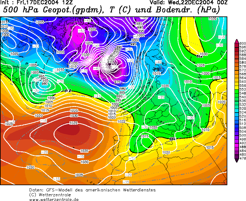
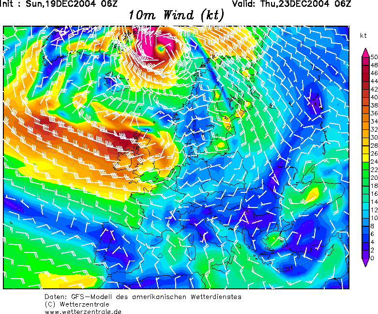
Infact it'll deepen down to around 940/935mbs which is very deep indeed and is infact progged to give sustained winds of over 50kts for a large area,infact on GFS wind it looks just a tad like a hurricane :P

here it is,when it forms I'll show you a saitlite image,I'm sure it'll be most impressive!

Image

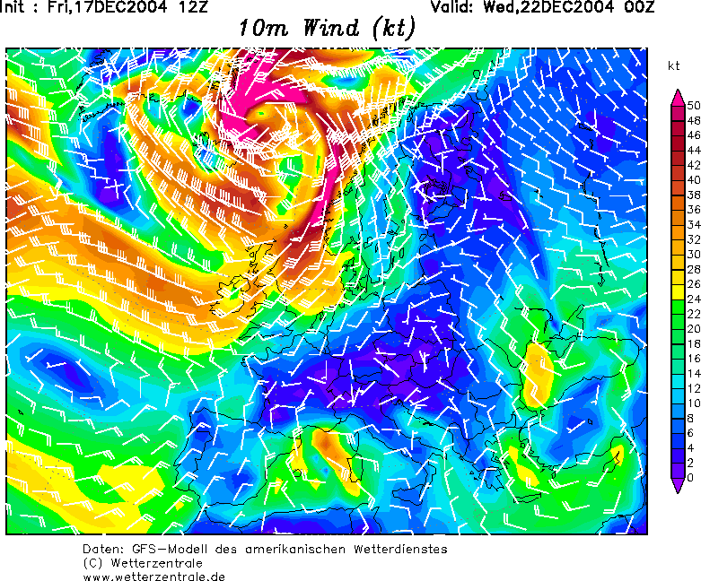
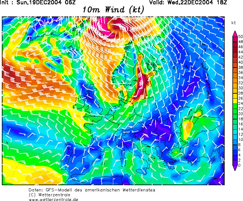
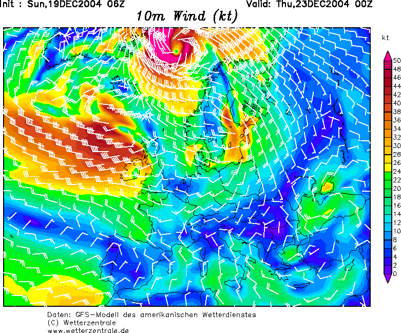
and heres the wind chart:

Image
Last edited by KWT on Sun Dec 19, 2004 6:22 am, edited 1 time in total.
0 likes   

User avatar
James
Category 5
Category 5
Posts: 1531
Joined: Tue Aug 24, 2004 10:29 am
Location: Gloucestershire, England
Contact:

#2 Postby James » Fri Dec 17, 2004 5:23 pm

It sure will be impressive! Looks like it's gonna be a rough run-up to Christmas this year.
0 likes   

User avatar
P.K.
Professional-Met
Professional-Met
Posts: 5149
Joined: Thu Sep 23, 2004 5:57 pm
Location: Watford, England
Contact:

#3 Postby P.K. » Fri Dec 17, 2004 5:41 pm

It does look fairly deep. http://129.13.102.67/pics/brack4a.gif
0 likes   

User avatar
KWT
Category 5
Category 5
Posts: 31416
Joined: Tue Aug 17, 2004 11:02 am
Location: UK!!!

#4 Postby KWT » Sun Dec 19, 2004 6:24 am

this is gonna be a very very deep storm indeed,infact at 927 it's gotta rank in the top 10 of the lowest pressures ever recorded outside of tropical systems and tornadoes.

It truely is an amazing system,and is progged to have sustained hurricane force winds around it as well as a eye,so it should be something very special to look at when it finally does form to its max!
0 likes   

User avatar
P.K.
Professional-Met
Professional-Met
Posts: 5149
Joined: Thu Sep 23, 2004 5:57 pm
Location: Watford, England
Contact:

#5 Postby P.K. » Sun Dec 19, 2004 7:48 am

Wow, very tightly packed isobars here (The 6am model run):

Image
Image
0 likes   

User avatar
KWT
Category 5
Category 5
Posts: 31416
Joined: Tue Aug 17, 2004 11:02 am
Location: UK!!!

#6 Postby KWT » Sun Dec 19, 2004 8:16 am

does anybody know how high the winds would go with isobars that packed,I expect its got sustained winds of a hurricane,but you'll see what I mean when I say it looks like a hurricane:

Image

Image

Image

I can't wait till it really gets going and actually starts to look impressive.
0 likes   

User avatar
P.K.
Professional-Met
Professional-Met
Posts: 5149
Joined: Thu Sep 23, 2004 5:57 pm
Location: Watford, England
Contact:

#7 Postby P.K. » Sun Dec 19, 2004 9:14 am

KWT wrote:does anybody know how high the winds would go with isobars that packed,I expect its got sustained winds of a hurricane,but you'll see what I mean when I say it looks like a hurricane:


If you look at the MetO FAX charts the scale on the top left is an indication of the geostrophic wind speed. The wind speed at sea level will be between 0.7 and 0.9 times this value over the sea. 0.9 is the maximum value and usually applies for deep systems like hurricanes.

You can also work it out directly by looking at the FAX chart and doing some calculations. Just got to remember how to do it. (Haven't done it in a while and I don't have those notes with me)
0 likes   

User avatar
P.K.
Professional-Met
Professional-Met
Posts: 5149
Joined: Thu Sep 23, 2004 5:57 pm
Location: Watford, England
Contact:

#8 Postby P.K. » Sun Dec 19, 2004 9:51 am

Looking at the 108hr MetO FAX chart where the isobars are most tightly packed I get a wind speed of 61m/s. Seems a bit high to me though (That is about 122kts :lol:) I've probably gone wrong somewhere in my calculations...
0 likes   


Return to “Talkin' Tropics”

Who is online

Users browsing this forum: No registered users and 389 guests