WXBLOG returns!! Complete update and FEB outlook...

Winter Weather Discussion

Moderator: S2k Moderators

Forum rules

The posts in this forum are NOT official forecast and should not be used as such. They are just the opinion of the poster and may or may not be backed by sound meteorological data. They are NOT endorsed by any professional institution or STORM2K.

Help Support Storm2K
Message
Author
User avatar
wxguy25
Professional-Met
Professional-Met
Posts: 708
Joined: Wed Oct 13, 2004 4:44 pm
Location: East Central Florida
Contact:

#21 Postby wxguy25 » Sun Jan 16, 2005 2:30 pm

DLI2k5 wrote:Hey there Wx! I'm from SC here and very curious to know what are the prospects for the possibility of some accumulating snow here. You had mentioned the upper or nothern part of SC maybe getting in on the act.


Right now, I think the BEST prospects for anything significant are north of you across NC and VA. But this event is still several days away and alot can change.

Although SC looks like it can get in on SOME accumulating snow. Mainly across the North.
0 likes   

User avatar
Chris the Weather Man
Category 2
Category 2
Posts: 746
Joined: Fri Dec 12, 2003 9:49 pm
Location: NJ

#22 Postby Chris the Weather Man » Sun Jan 16, 2005 2:31 pm

LOL, Take it easy! LOL

And how often is the UKMET is correct?
0 likes   

User avatar
wxguy25
Professional-Met
Professional-Met
Posts: 708
Joined: Wed Oct 13, 2004 4:44 pm
Location: East Central Florida
Contact:

#23 Postby wxguy25 » Sun Jan 16, 2005 2:32 pm

Chris the Weather Man wrote:LOL, Take it easy! LOL

And how often does the UKMET is correct?


the UKMET does handle phasing the best.
0 likes   

User avatar
Chris the Weather Man
Category 2
Category 2
Posts: 746
Joined: Fri Dec 12, 2003 9:49 pm
Location: NJ

#24 Postby Chris the Weather Man » Sun Jan 16, 2005 2:34 pm

That's what I believed and heard about....
0 likes   

AnthonyC
Category 2
Category 2
Posts: 734
Joined: Fri Jan 07, 2005 4:38 pm

#25 Postby AnthonyC » Sun Jan 16, 2005 2:46 pm

wxguy25,

Latest indications suggest a negative AO and negative PNA phase toward the end of January, beginning of February. If this were to evolve, the Pacific Northwest would be in heaven!! What are your thoughts on this?

Anthony
0 likes   

User avatar
wxguy25
Professional-Met
Professional-Met
Posts: 708
Joined: Wed Oct 13, 2004 4:44 pm
Location: East Central Florida
Contact:

#26 Postby wxguy25 » Sun Jan 16, 2005 3:55 pm

AnthonyC wrote:wxguy25,

Latest indications suggest a negative AO and negative PNA phase toward the end of January, beginning of February. If this were to evolve, the Pacific Northwest would be in heaven!! What are your thoughts on this?

Anthony


Sorry nice try. But NOT going to happen.

Latest indications from what? The GFS ensembles and the associated idiocy that comes with each run?
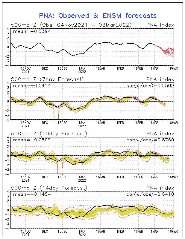
Image

Look at the 14-day verification (last panel). The Ensembles have been doing a TREEIBLE job w/ the PNA and other teleconnections all winter.

I don’t see how the +PNA breaks down over the next 5-15 days as long as the NAO is negative and the 50-50 low is in place over eastern Canada. The jet cannot break through to crush the ridge unless that’s gone. Plus the MJO is in stage 6 – entering stage 7 which favors a + PNA pattern.

http://www.wxguy.storm2k.org/wxblog/40daymjo.gif

The Atlantic SSTA configuration is becoming increasingly favorable for a –NAO and as a result the good days in the PAC northwest are probably over. You are NOT going to get the strong RNA pattern unless the NAO is positive.

Notice the split developing across the North Atlantic.

http://weatheroffice.ec.gc.ca/data/sais ... _gl_sd.gif

As the MJO reloads the PAC jet may return for a week or week and a half at some point in FEB depending on how long it takes for the next phase to develop and push eastward.

Here are the AO ensembles. Look at that 14-day (lack of) verification. It is complete illogicality.
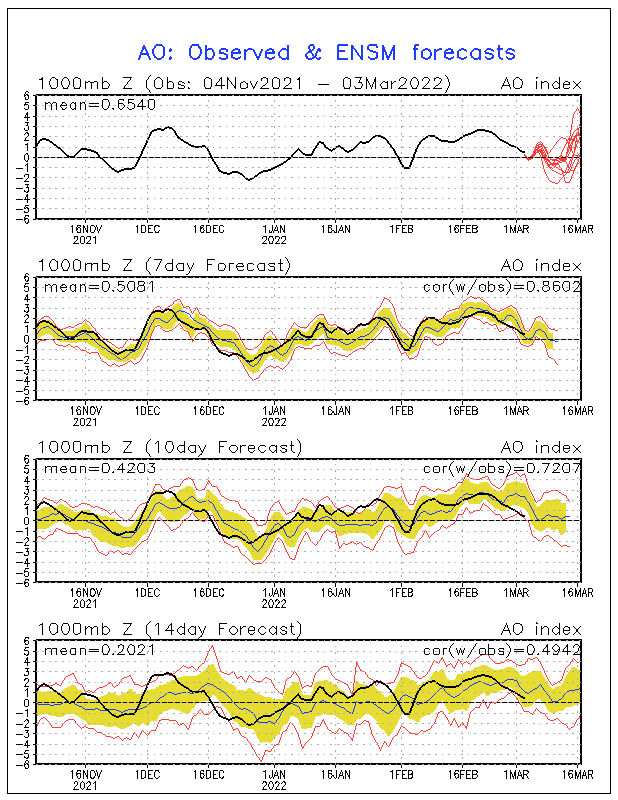
Image

Here is the 0z D8-10 ecmwf. Notice the vertically stacked upper low over SE Canada. THIS is the 50-50 low and as long as it holds, the EUS trough will remain amplified and keep the PNA ridge up near 120 W.

The 12z D 7 ECMNWF actually had a strong Rex Block signature along the west coast near 120W. This is a horrible pattern for the PAC NW.

It’s like the song says “heaven isn’t too far away” for the EAST that is. In the PAC NW --- I’M convinced your best days are over.
0 likes   

Anonymous

#27 Postby Anonymous » Sun Jan 16, 2005 4:15 pm

Is philly in on any of the action? What does RIC mean wxguy25?
0 likes   

User avatar
wxguy25
Professional-Met
Professional-Met
Posts: 708
Joined: Wed Oct 13, 2004 4:44 pm
Location: East Central Florida
Contact:

#28 Postby wxguy25 » Sun Jan 16, 2005 4:17 pm

Jrodd321 wrote:What does RIC mean wxguy25?


RICHMOND, VA
0 likes   

Anonymous

#29 Postby Anonymous » Sun Jan 16, 2005 4:22 pm

Is philly in on any of the action? Can you give me a model to look at to see the people who are supposed to get hit?
0 likes   

AnthonyC
Category 2
Category 2
Posts: 734
Joined: Fri Jan 07, 2005 4:38 pm

#30 Postby AnthonyC » Sun Jan 16, 2005 4:22 pm

wxguy25,

Most of those charts/ensembles show a turn toward a negative PNA phase. What are YOU looking at?! And even the AO charts/ensembles show a relative trend toward a negative phase.

Anthony
0 likes   

User avatar
wxguy25
Professional-Met
Professional-Met
Posts: 708
Joined: Wed Oct 13, 2004 4:44 pm
Location: East Central Florida
Contact:

#31 Postby wxguy25 » Sun Jan 16, 2005 4:28 pm

AnthonyC wrote:wxguy25,

Most of those charts/ensembles show a turn toward a negative PNA phase. What are YOU looking at?! And even the AO charts/ensembles show a relative trend toward a negative phase.

Anthony


What I'm saying is I think the GFS ensembles are WRONG. as they have been all winter.

Forecasting is not all about charts and graphs, ensembles, and numerical weather data. you have to understand cause and effect WRT to the pattern. Looking at the GFS ensembles are NOT going to help you. IF you looked at the ECMWF link I posted you would see it totally contradicts the GFS ensembles.

What I do think the GFS ensembles are correct about is the AO trending negative. Supported by the Changes in the Atlantic SSTA configuration.
0 likes   

User avatar
Chris the Weather Man
Category 2
Category 2
Posts: 746
Joined: Fri Dec 12, 2003 9:49 pm
Location: NJ

#32 Postby Chris the Weather Man » Sun Jan 16, 2005 5:42 pm

Hmmm........... This might be a doozy...


By the way, I heard of a 3 wave pattern happening? What is a 3 wave patten? I heard of it, has 3 PVs? Not really sure....
0 likes   

User avatar
wxguy25
Professional-Met
Professional-Met
Posts: 708
Joined: Wed Oct 13, 2004 4:44 pm
Location: East Central Florida
Contact:

#33 Postby wxguy25 » Sun Jan 16, 2005 7:29 pm

Chris the Weather Man wrote:Hmmm........... This might be a doozy...


By the way, I heard of a 3 wave pattern happening? What is a 3 wave patten? I heard of it, has 3 PVs? Not really sure....


three predominant longwave troughs over the northern hemisphere
0 likes   

User avatar
Chris the Weather Man
Category 2
Category 2
Posts: 746
Joined: Fri Dec 12, 2003 9:49 pm
Location: NJ

#34 Postby Chris the Weather Man » Sun Jan 16, 2005 7:46 pm

wxguy25 wrote:
Chris the Weather Man wrote:Hmmm........... This might be a doozy...


By the way, I heard of a 3 wave pattern happening? What is a 3 wave patten? I heard of it, has 3 PVs? Not really sure....


three predominant longwave troughs over the northern hemisphere


Thank You very much.... Now, I heard that if that forms, there could be a Major Arctic Outbreak?
0 likes   

User avatar
hurricanemike
Professional-Met
Professional-Met
Posts: 197
Joined: Wed Feb 25, 2004 11:33 pm
Location: Jacksonville,FL Beaches/Duval County
Contact:

N FL?

#35 Postby hurricanemike » Sun Jan 16, 2005 7:54 pm

Does N FL have the possiblity of seeing anything?
0 likes   

Anonymous

#36 Postby Anonymous » Sun Jan 16, 2005 8:20 pm

Wxguy, you say... "**IF** and I stress the word **IF** this is correct then we would be talking about a MAJOR east coast snowstorm from Northern SC to Maine. A MILLER B situation nonetheless (clipper bombs off the coast), BUT with the SLP deepening well below 1000mb before reaching the VA capes, this is likely a HIT for PHL-NYC and certainly New England." What does all this mean??? That either way the the storm will hit philly and nyc?
0 likes   

User avatar
Stephanie
S2K Supporter
S2K Supporter
Posts: 23843
Age: 63
Joined: Thu Feb 06, 2003 9:53 am
Location: Glassboro, NJ

#37 Postby Stephanie » Sun Jan 16, 2005 8:30 pm

Jrodd321 wrote:Wxguy, you say... "**IF** and I stress the word **IF** this is correct then we would be talking about a MAJOR east coast snowstorm from Northern SC to Maine. A MILLER B situation nonetheless (clipper bombs off the coast), BUT with the SLP deepening well below 1000mb before reaching the VA capes, this is likely a HIT for PHL-NYC and certainly New England." What does all this mean??? That either way the the storm will hit philly and nyc?


Yes, IF that is correct.
0 likes   

User avatar
Yankeegirl
Category 5
Category 5
Posts: 3417
Age: 49
Joined: Sun May 23, 2004 11:59 pm
Location: Cy-Fair, Northwest Houston
Contact:

#38 Postby Yankeegirl » Sun Jan 16, 2005 8:31 pm

I am not really good at reading the maps and stuff, can you let me know if Houston is done with winter or if Feb is going to be a cold month... I would really like to see some more of the frozen precip here, the stuff at Christmas time was just a tease!!
0 likes   

User avatar
wxguy25
Professional-Met
Professional-Met
Posts: 708
Joined: Wed Oct 13, 2004 4:44 pm
Location: East Central Florida
Contact:

#39 Postby wxguy25 » Sun Jan 16, 2005 9:18 pm

Stephanie wrote:
Jrodd321 wrote:Wxguy, you say... "**IF** and I stress the word **IF** this is correct then we would be talking about a MAJOR east coast snowstorm from Northern SC to Maine. A MILLER B situation nonetheless (clipper bombs off the coast), BUT with the SLP deepening well below 1000mb before reaching the VA capes, this is likely a HIT for PHL-NYC and certainly New England." What does all this mean??? That either way the the storm will hit philly and nyc?


Yes, IF that is correct.


I no longer see that as being a feasible solution

UNLESS there is a major change in the way the models interpret the synoptic set-up I see no way the s/w could come up the coast w/ the 50-50 low there. It should get shoved out to sea.

What we MAY see is a swath of significant snow beginning over the upper Midwest 5-100 Miles north of the track of s/w that tapes off somewhat across the lower OV and WRN Mid Atlantic region – However THEN as the SFC low jumps to the coast (MILLER B Situation where a clipper re-develops along the coast and bombs out) it will throw back ATRL moisture and we would be talking about a Significant snowstorm for ERN NC, VA, SRN MD, DE, S NJ. The major cities DCA-BWI-PHL being on the fence, and NYC-BDL-BOX out of the loop.

Maps illustrating this idea will be out soon.
0 likes   

User avatar
wxguy25
Professional-Met
Professional-Met
Posts: 708
Joined: Wed Oct 13, 2004 4:44 pm
Location: East Central Florida
Contact:

Re: N FL?

#40 Postby wxguy25 » Sun Jan 16, 2005 9:19 pm

hurricanemike wrote:Does N FL have the possiblity of seeing anything?


Much colder temps, yes. Snow or frozen precip from the clipper probably not.
0 likes   


Return to “Winter Weather”

Who is online

Users browsing this forum: No registered users and 13 guests