
The winds are dead calm once again. It was an hour period that brought sustained winds of 20-35 G50 mph. Pretty impressive wind burst. There already seems to be a debate over the potential cold spell in late January, early February. Since you can't trust the GFS model more than 72 hours in advance, there's not much to say as of now. But if I were to lean toward a gut feeling, I would say an arctic outbreak is not out of the question. We have many factors that favor this evolution; the PNA and AO are expected to trend toward the negative side, the current pineapple express is usually a precursor to a cold blast and some forecast models point to an amplified ridge at the critical 150W mark. So if I were to either say "yeah" or "nah" for the arctic blast, I would say "yeah". But that could change tomorrow.
Anthony
Currently 59 F!!!
Pacific Northwest Weather
Moderator: S2k Moderators
Forum rules
 The posts in this forum are NOT official forecast and should not be used as such. They are just the opinion of the poster and may or may not be backed by sound meteorological data. They are NOT endorsed by any professional institution or STORM2K.

The posts in this forum are NOT official forecast and should not be used as such. They are just the opinion of the poster and may or may not be backed by sound meteorological data. They are NOT endorsed by any professional institution or STORM2K.
-
andycottle
- Category 5

- Posts: 1139
- Joined: Thu Jan 06, 2005 11:34 pm
- Location: Woodinville, Wa

-
andycottle
- Category 5
- Posts: 1139
- Joined: Thu Jan 06, 2005 11:34 pm
- Location: Woodinville, Wa
-
TT-SEA
Wizzard... there is nothing to indicate an arctic outbreak.
Looking back at years with a pattern like this in January... most had a normal remainder of winter. At least lower snow levels will be coming.
I think the recent cold pattern... although the puzzle pieces did not come together perfectly for Seattle... was extreme. The PNA was off the chart negative and California had record rain and snow.
I think this Pineapple Express and our 60+ degree weather is the balancing of that pattern. We are now back to even... and I just feel the winter will finish on a normal note.
Just one man's opinion. We will see... but I think you are going to be disappointed.
0 likes
-
andycottle
- Category 5
- Posts: 1139
- Joined: Thu Jan 06, 2005 11:34 pm
- Location: Woodinville, Wa
Weather Outlook:
Viewing tonight latest GFS of the 18z run, and the MRF...tomorrow should mainly feature cloudy skies with a few light showers of .10" or less most areas...per 6hr precip 24hr totals, and highs in the mid-upper 50`s per Seattle MOS. Places right up near the Wa, Canada border 'may' recieve about .25"(plus or minus that amount). But generally, precip will be on the light side. First half of Thursday may end up being dry, though should see some more decent rains later on in the day. 48hr precip totals for the 12hr period Thursday are .50 to .75" for South and Central sound areas, while far Northern sound and Wa. Coast areas could possibly pick up near an 1.00" of rain. Friday and maybe most of Saturday could feature a few light showers and some good sunbreaks. Long range... looks like mostly showers through the 31st and possibly turning a tad cooler for the 31st and Feb. 1st. Though, it`s only a tad, as 500MB heights are 522 to 534DM. For 2nd and 3rd of Febuary, looks like heights rise a little above the 540DM mark. And lastly...looks like the Jet Stream stays mostly in a zonal flow through the 384hr period.
-- Andy
0 likes

-
snow_wizzard
- Category 4

- Posts: 994
- Joined: Mon Jan 17, 2005 12:15 am
- Location: Covington, WA
-
TT-SEA
-
snow_wizzard
- Category 4
- Posts: 994
- Joined: Mon Jan 17, 2005 12:15 am
- Location: Covington, WA
I look at the GFS showing progressively colder weather as a bonus. The sequence of events has already fulfilled the requirements for a major cold spell. I think you should really look at hard at those progs for the 11 - 15 day period. A lot of notherly and even NNE flow....Then you have that sharp short wave dropping down the BC coast at the end.
0 likes
-
TT-SEA
Freaky weather tonight.
The temperature has gone up to 64.8 degrees right now. The school site in North Bend shows 64.4 degrees.
Its 10:30 p.m. AND its January.
That has to be some kind of record.
I would say there is probably 2 nights on average in June that are still at 64.8 degrees at 10 p.m.
Global warming.
The temperature has gone up to 64.8 degrees right now. The school site in North Bend shows 64.4 degrees.
Its 10:30 p.m. AND its January.
That has to be some kind of record.
I would say there is probably 2 nights on average in June that are still at 64.8 degrees at 10 p.m.
Global warming.
0 likes
-
TT-SEA
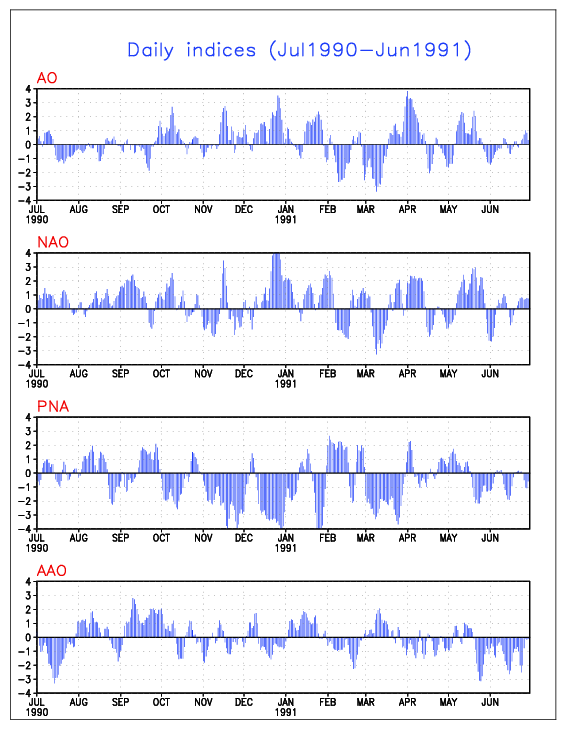
Here is a look at the indices from the famous arctic blast in December 1990.
Notice the PNA was strongly negative... not just moderately negative. The AO was strongly positive.
I see nothing to this extreme coming our way now. Not even close.
The PNA is expected to go slightly negative towards the end of the month and the AO is also forecasted to go slightly negative.
Notice the PNA was strongly negative... not just moderately negative. The AO was strongly positive.
I see nothing to this extreme coming our way now. Not even close.
The PNA is expected to go slightly negative towards the end of the month and the AO is also forecasted to go slightly negative.
0 likes
-
TT-SEA

-
andycottle
- Category 5
- Posts: 1139
- Joined: Thu Jan 06, 2005 11:34 pm
- Location: Woodinville, Wa
Tim and all. Looking back my high temps along with other obs from the past 4yrs I`ve been writing down... January, 7th. 2001...we had ahigh of 61. And in January 2003, we had a high 62(2nd), 60(3rd & 5th) 66(6th), and 62(the 26th). So thoes are the very warmest temps that I have seen during thoes January months.
-- Andy
-- Andy
0 likes
-
andycottle
- Category 5
- Posts: 1139
- Joined: Thu Jan 06, 2005 11:34 pm
- Location: Woodinville, Wa


-
snow_wizzard
- Category 4
- Posts: 994
- Joined: Mon Jan 17, 2005 12:15 am
- Location: Covington, WA
TT...It is possible, if not likely that this coming cold spell will begin modestly and become progessively more extreme. We should go below normal around day 10 or 11 and then just sink lower from there. The index forecasts only go out to day 14 or so. It could go below -3 after that, maybe even before. I am looking for past events like this. Jan 1902 had a warm period very much like this and two weeks later we got slammed by bitter cold and a major snowstorm. This is not global warming. Dec 1861 had almost tropical temps just before we plunged into a 2 and 1/2 month cold wave. This kind of warmth is common before our most severe cold spells. Anyway...the first half of January had the lowest average of any Jan since 93. I can throw out facts like this for days....
0 likes


-
TT-SEA
55.8 degrees and no rain yet today.
As I predicted three days ago and repeated yesterday... today will be a pretty dry day for almost all of Western Washington. The morning run of the ETA verifies this fact. The plume is now in Canada.
Despite the local media screaming "FLOODING IS EXTREME AND THERE IS NO BREAK IN SIGHT FOR THE NEXT WEEK".
Today will actually be a very nice break. And warm too.
0 likes
-
TT-SEA
Who is online
Users browsing this forum: WaveBreaking, wxman22 and 60 guests