Andy... I should have checked the latest GFS first. There is very little rain on that run. Are you sure you are looking at the right run?
Wizzard... $100 hmmmm. Remember the cycle could be longer and it could return to a snowy pattern in 2040. You would still be right about the cycle but we would pretty old by then!!
You have no way of knowing if that 70 year cycle last time was normal or not. There is simply not enough data. Even if it was normal cycle that would be 2020 at the earliest. You can study all the records you want from 1880 to present but when looking at cycles that is a short time.
I appreciate your confidence but it is impossible to really know... particularly given the recent warming of the Earth.
Pacific Northwest Weather
Moderator: S2k Moderators
Forum rules
 The posts in this forum are NOT official forecast and should not be used as such. They are just the opinion of the poster and may or may not be backed by sound meteorological data. They are NOT endorsed by any professional institution or STORM2K.

The posts in this forum are NOT official forecast and should not be used as such. They are just the opinion of the poster and may or may not be backed by sound meteorological data. They are NOT endorsed by any professional institution or STORM2K.
-
snow_wizzard
- Category 4

- Posts: 994
- Joined: Mon Jan 17, 2005 12:15 am
- Location: Covington, WA
TT...I think you are right about the Pineapple Express. It may not really be a wet one, but it will likely be warm, albeit not as warm as this past one. Keep in mind though, the last one was with warm weather in Alaska, this one will be with cold. The pattern is shifting. Another huge difference is the east will not be cold with this one. Changes are taking place.
I don't think I am going to post for a while. The negativity on here is simply driving me crazy. I bring a wealth of experience to the table. There are probably few people who know as much about the weather history around here as I do. Climatology is my specialty, and I feel my posts are falling on deaf ears. Perhaps you will see the book I am working on in your local book store some day (if it ever gets done).
For now, I will say that within a week the models will be showing plenty of excting weather for us.
0 likes

Since TT and Snow_wizzard think a Pineapple Express will come, that has to mean the ridge is backing off somewhat doesn't it? After the predicted Pineapple Express, will the stream of storms move to our north or to our south and what is going to happen with the ridge once it does move?
EDIT: Of course the models seem to keep the ridge in place with most of the moisture headed to the north, but I just want to see if your opinions differ.
EDIT: Of course the models seem to keep the ridge in place with most of the moisture headed to the north, but I just want to see if your opinions differ.
Last edited by andrewr on Thu Jan 27, 2005 12:11 am, edited 1 time in total.
0 likes

-
andycottle
- Category 5

- Posts: 1139
- Joined: Thu Jan 06, 2005 11:34 pm
- Location: Woodinville, Wa
TT-SEA wrote:Andy... I should have checked the latest GFS first. There is very little rain on that run. Are you sure you are looking at the right run?
Wizzard... $100 hmmmm. Remember the cycle could be longer and it could return to a snowy pattern in 2040. You would still be right about the cycle but we would pretty old by then!!
You have no way of knowing if that 70 year cycle last time was normal or not. There is simply not enough data. Even if it was normal cycle that would be 2020 at the earliest. You can study all the records you want from 1880 to present but when looking at cycles that is a short time.
I appreciate your confidence but it is impossible to really know... particularly given the recent warming of the Earth.
Tim....the GFS I had been looking at was from earlier today. Tonights GFS run shows much less rain. Will give an outlook here in a bit. -- Andy
0 likes

Wow, I continue to marvel at the December 1996 snowstorm. I'm telling you right now...Western Washington may not see another storm like that for at least 20 years...if not ever. Have a research assignment for R-Dub...what was the PNA and AO during that period? Were they both extremely negative? And I never realized the problems that arose after the snow finally changed to rain. Amazing stuff.
Once the snow finally changed to rain the morning of the 30th, there was HEAVY rain ALL day and a minor windstorm...so basically every type of winter weather you could experience. After looking at all the snowfall amounts given by each station, I would say Mukilteo had anywhere between 20-30 inches on the ground...some places in Bellingham had over 40 INCHES!!! Can you imagine? Not only that, but a rare Blizzard Warning was posted for Bellingham the morning of the 30th. How often do we see that?
What an amazing storm. What an amazing winter season. It still gives me hope that Seattle can have GOOD winters...albeit they are rare.
TT-SEA...did you notice there was NO rainshadow throughout the entire Dec. 1996 event? What's up with that? Not even Sequim experienced a rainshadow. Has anything changed?
Snow_Wizzard...I honestly believe our climate has changed...albeit slight...to some degree. A change of 1 F higher can have a major affect especially for the lowland regions.
Anthony
0 likes
-
TT-SEA
Snow_Wizzard... I am not sure why factual debate is negative?
If I only loved warm weather I would find all this talk about snow and cold negative.
I just love the weather. I love following the patterns and figuring out whats coming next. I don't think of snow... rain... warm... or cold as being negative. Remember how excited I was when we got hit with snow here in North Bend?
I hate fog and stagnant inversions... but if the pattern showed high pressure and an inversion forming I would be the first to report that fog was coming.
Does this make sense?
I truly appreciate your knowledge. I find historical weather records fascinating. I read every one of your posts with great interest. I highly encourage you to write a book. I would be the first one to buy it. Trust me.
But don't be too single-minded about arctic air... it can cloud (no pun intended) your objectivity and enjoyment of weather in general.
0 likes
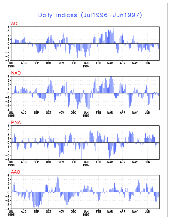
Anthony, here is the link to the 1996-97 PNA, AO, NAO, Ect. Looks like PNA tanked around the 17th or so, then came up to almost neutral, then dropped to just under -2 for the big event. AO was around -3 if I am reading this right.
http://www.cpc.ncep.noaa.gov/products/p ... x.1996.gif
http://www.cpc.ncep.noaa.gov/products/p ... x.1996.gif
0 likes
-
TT-SEA
Anthony... here are some comments from a previous post I wrote...
I just learned during the last arctic outbreak (from a Spokane AFD) that a cold air dome essentially "masks" the mountains in an over-running situation. The warm air going up and over the cold dome produces snow and the cold air is so dense that enhancement or downsloping from the mountains is negated. The result is that the snow just falls uniformly to the ground.
A perfect example from the tape... there was a great deal of footage from North Bend and it showed some intense wind there. That was an easterly wind and should have caused downsloping and dried the air. But North Bend got as much (or more) snow than other places in Western Washington.
0 likes
Alright, I've had as much as I can take tonight...watching those tapes are awesome, but exhausting at the same time!! lol. Thanks for the info R-Dub...looks as if the PNA went down to -5 in the middle of December then eventually headed towards neutral. The AO was extremely negative throughout the entire event...maybe that's what we were missing with this last event? lol.
Interesting snippett of the December 1990 arctic express...ALOT of snow fell then...almost 10 inches in downtown Seattle. It's truly amazing to see snowplows get stuck on the streets of Seattle. Just doesn't happen very often.
Snow_Wizzard...you factual information about weather is amazing. Please don't leave the site...I look forward to reading your posts on a daily basis. But sometimes...and I myself do the same thing...you get too carried away with arctic air. You can never trust long-range models...I've learned that this winter season. And to get your hopes up every day, and then have them crushed when the GFS does a 180 really sucks. So just chill with the snow/cold...if it wants to come, it'll come. Maybe don't check the long-range models everyday? Maybe check them every other day?
Goodnite to all...and once again, THANK YOU R-DUB FOR THE TAPES!!!
Anthony
0 likes
-
andycottle
- Category 5
- Posts: 1139
- Joined: Thu Jan 06, 2005 11:34 pm
- Location: Woodinville, Wa
Hi folks.
Taking a look at tonights 00z GFS 48 and 60hr precip totals for Feb. 1st - 3rd....looks like this expected pineappel express isn`t going to be as wet as was shown in todays earlier models. Now it appears that we may see only about .50" of rain during this time frame ending 06z Wednesday evening. SW facing slopes of the Olympics may get a bit more if there is up sloping winds. 850MB heights still appearing around +3 to +6C and unbelievable heights of 1560 to 1590M! We are going to be WARM! 700MB heights are around 3120 to 3150M with humidity of about 70%. 500MB voricity heights still extremely high...and are 570 to almost 576DM. Looks like mainly a zonal flow through the 384hr period with the exception of maybe a weak high around the 31st of this month. -- Andy
Taking a look at tonights 00z GFS 48 and 60hr precip totals for Feb. 1st - 3rd....looks like this expected pineappel express isn`t going to be as wet as was shown in todays earlier models. Now it appears that we may see only about .50" of rain during this time frame ending 06z Wednesday evening. SW facing slopes of the Olympics may get a bit more if there is up sloping winds. 850MB heights still appearing around +3 to +6C and unbelievable heights of 1560 to 1590M! We are going to be WARM! 700MB heights are around 3120 to 3150M with humidity of about 70%. 500MB voricity heights still extremely high...and are 570 to almost 576DM. Looks like mainly a zonal flow through the 384hr period with the exception of maybe a weak high around the 31st of this month. -- Andy
0 likes

-
andycottle
- Category 5
- Posts: 1139
- Joined: Thu Jan 06, 2005 11:34 pm
- Location: Woodinville, Wa
EDIT: Just fixing a few minor typos..lol 
Hi folks.
Taking a look at tonights 00z GFS 48 and 60hr precip totals for Feb. 1st - 3rd....looks like this expected pineappel express isn`t going to be as wet as was shown in todays earlier models. Now it appears that we may see only about .50" of rain during this time frame ending 06z Wednesday evening. SW facing slopes of the Olympics may get a bit more if there is up sloping winds. 850MB temps still appearing around +3 to +6C and unbelievable heights of 1560 to 1590M! We are going to be WARM! 700MB heights are around 3120 to 3150M with humidity of about 70%. 500MB voricity heights still extremely high...and are 570 to almost 576DM. Looks like mainly a zonal flow through the 384hr period with the exception of maybe a weak high around the 31st of this month. -- Andy[code][/code]
0 likes
-
andycottle
- Category 5
- Posts: 1139
- Joined: Thu Jan 06, 2005 11:34 pm
- Location: Woodinville, Wa
Warm in the West, not all that cold in the East
Looking at the NCEP Ensemble MRF tonight, the western U.S will be on the mild side, while the east will be coolish but not in any kind of bitter cold. http://www.cdc.noaa.gov/map/images/ens/ensmean_usbg_animation.html
-- Andy
-- Andy
0 likes
-
andycottle
- Category 5
- Posts: 1139
- Joined: Thu Jan 06, 2005 11:34 pm
- Location: Woodinville, Wa
Good morning all....rise and shine..lol 
Looking this morning models from the NECP and CDC site....it now looks as if this Pineappel express wont be developing early next as was shown in last nights models. GFS 06z 48 to 64hr precip total for 1st - 3rd of Feb, show no acumulating precip untill 06z Thursday evening in which it`s only .10" precip by then. So instead...it appears that we have a 1032MB high pressure system that will keep us dry from the the 31 to about the 3rd of Feb. Though MRF from the CDC site, disagrees and shows some precip during this time. -- Andy

Looking this morning models from the NECP and CDC site....it now looks as if this Pineappel express wont be developing early next as was shown in last nights models. GFS 06z 48 to 64hr precip total for 1st - 3rd of Feb, show no acumulating precip untill 06z Thursday evening in which it`s only .10" precip by then. So instead...it appears that we have a 1032MB high pressure system that will keep us dry from the the 31 to about the 3rd of Feb. Though MRF from the CDC site, disagrees and shows some precip during this time. -- Andy
0 likes
-
andycottle
- Category 5
- Posts: 1139
- Joined: Thu Jan 06, 2005 11:34 pm
- Location: Woodinville, Wa
Hi again, folks. Gee...guess everyone is busy today..lol.
Anyway...looking at the 12z GFS 48 and 60hr precip totals for early next week, it`s not seeming all that wet considering what was being shown yesterday and day before. Precip totals for 00z Monday the 31 through 06z Feb, 3rd. is only around .10 to .25" of precip, and then going totaly dry for 00z Friday the 4th. So it looks like that tropical abundant, moisture laden clouds will be dumping the RAINS on the Central B.C coast line during the 31st - Feb, 4th.
During this time, 850MB temps are around +6C with heights of between 1560 to 1590 and even close to 1620M. 700MB heights are 3120, and going up to around 3180M by Friday of next week. 500MB voricity heights appear around 570 to 576DM and even getting close to 582DM. So our weather is looking quite WARM here folks for next week. Hmmmm....all these high heights in the upper layers of the our atmosphere tells me we could easily see high temps in the mid-upper 60`s. And maybe a few 70 degree temps would not be out of the question. So we`ll see how things turn out!
-- Andy
0 likes
Who is online
Users browsing this forum: steviegcomeback, tolakram and 31 guests