Pacific Northwest Weather

Winter Weather Discussion

Moderator: S2k Moderators

Forum rules

The posts in this forum are NOT official forecast and should not be used as such. They are just the opinion of the poster and may or may not be backed by sound meteorological data. They are NOT endorsed by any professional institution or STORM2K.

Help Support Storm2K
Message
Author
User avatar
W13
Category 5
Category 5
Posts: 1938
Joined: Sun Jul 18, 2004 2:46 pm
Location: Kent, Washington

#2881 Postby W13 » Tue Mar 01, 2005 6:08 pm

vbhoutex wrote:
AnthonyC wrote:Snow_Wizzard,

It's march. Time for Spring and Summer. I'm tired of Winter...esp. this Winter. Nothing exciting has happened...no decent lowland snow event, no big snowstorm, no huge mountain snows...if you can't get any of those, why continue with Winter?! At this point, I want sunny conditions with temperatures near 75F. That would be perfect for me. And if current forecasts are correct, next week could come close to those numbers.


Because I don't like the 100º+ we get during the summer!!! :D :D :D

Oh wait, wrong part of the country!! :wink: :wink: :wink: :wink: Actually don't some of the desert/more arid areas in Washington get into the 100's during the summer?


Yes, Eastern Washington does regularly get into the 100's during the summer, while Western Washington (at least in the past few years), has a few days of mid to high 90's, and some 100 degree readings in the warmer spots.
0 likes   

Guest

#2882 Postby Guest » Tue Mar 01, 2005 6:08 pm

Hmm, just like the last several runs, the 18z shows an overall pattern shift around day 11 with northely flow shortly after that... And DUHHH THE NEXT 7 DAYS LOOK WARM... IT'S PRETTY OBVIOUS BY NOW TT...
0 likes   

Guest

#2883 Postby Guest » Tue Mar 01, 2005 6:10 pm

If you were really a weather fan you wouldn't be bashing people who are interested in a pattern shift and some actual EXCITING WEATHER...
0 likes   

AnthonyC
Category 2
Category 2
Posts: 734
Joined: Fri Jan 07, 2005 4:38 pm

#2884 Postby AnthonyC » Tue Mar 01, 2005 6:22 pm

Come on Brennan and TT-SEA...you guys feed off one another. Brennan...don't take everything TT-SEA says so seriously. TT-SEA...stop feeding into Brennan. You guys have been like this for many weeks...STOP! One wants cold, snow the other warm, sunny. Just deal with it. Respect each other. Cool?!

Very nice day outside. I was expecting alot more rain today, but looking at the latest satellite it looks like that system is falling apart off the coast. That ridge in Western Canada is ridiculously strong. It's blocking everything and anything from affecting Washington and Oregon.

Anthony
0 likes   

Guest

#2885 Postby Guest » Tue Mar 01, 2005 6:26 pm

Actually Anthony I hope it gets downright HOTT next week... Highs in the 70's with beautifully sunny skies... But also, the week after that I want a pattern shift with colder weather and possibly snow...
0 likes   

User avatar
R-Dub
Category 5
Category 5
Posts: 1427
Joined: Thu Dec 30, 2004 2:18 pm
Location: Stanwood, WA
Contact:

#2886 Postby R-Dub » Tue Mar 01, 2005 6:31 pm

Don't know what the deal was this morning, think its my computer having issues, luckly I can get on the site once again!!
Thanks for letting me know that it was just me having issues with the site Anthony!!

Been a nice warm partly cloudy day today, not bad at all!!

3/1/05 LK Goodwin WA
3:23:50 PM CURRENT
Cloudy
Temperature (ºF) 58.3
Humidity (%) 44.8
Wind (mph) WSW
Daily Rain (") 0.07
Pressure ("Hg) 29.86
Dew Point: 38.0 ºF
0 likes   

User avatar
R-Dub
Category 5
Category 5
Posts: 1427
Joined: Thu Dec 30, 2004 2:18 pm
Location: Stanwood, WA
Contact:

#2887 Postby R-Dub » Tue Mar 01, 2005 6:40 pm

Just figured out why I was having troubles, I was stupid and bit off on it. Site was hacked this morning, here is a thread about it...........

http://www.storm2k.org/phpbb2/viewtopic.php?t=58575

Currently 56.8 degrees
Cloudy
0 likes   

AnthonyC
Category 2
Category 2
Posts: 734
Joined: Fri Jan 07, 2005 4:38 pm

#2888 Postby AnthonyC » Tue Mar 01, 2005 7:37 pm

Brennan,

That would be awesome!! Sunny conditions with temperatures around 75F one week...and then BAM! lowland snow with temperatures near 30F!! I wonder what all the plants would think about that?!

NWS forecast still indicates the warmest temperatures of the season beginning next week. Sounds good to me!

Anthony
0 likes   

snow_wizzard
Category 4
Category 4
Posts: 994
Joined: Mon Jan 17, 2005 12:15 am
Location: Covington, WA

#2889 Postby snow_wizzard » Tue Mar 01, 2005 8:15 pm

Yeah...I was dumb enough to try to download that plugin last night. Thank goodness my virus scan said, no you don't! It looked so cheesey and unprofessional, I should have known better.

Anthony...I knew you still wanted to see some weather! You are an addict, just admit it.

the 18z continues to look really fun after day 10. If this all plays out as expected, I will be convinced we have entered our cold climate phase. The fact is that kind of extreme variability does not happen in our warm phase. If it's a warm phase we would just see it get warm and not be answered with a sharp cool period afterward. The next two months are going to tell us a lot about where we stand!
0 likes   

TT-SEA

#2890 Postby TT-SEA » Tue Mar 01, 2005 8:32 pm

Are you telling me that if we have a cool shot of air in two weeks that will mean we have entered a different climate phase???

We will know where we stand in 2 months??

We will NOT know anything more in 2 months.

Trust me.

In fact... there is no such thing as "knowing" what will happen in the next few years. No way dude.
0 likes   

invisible
Tropical Depression
Tropical Depression
Posts: 60
Joined: Tue Feb 08, 2005 11:19 pm
Location: Aldergrove, B.C

#2891 Postby invisible » Tue Mar 01, 2005 8:42 pm

I think we will be in cooler pattern after 10 days because PNA maybe will drop really quickly from plus 5 to minus one in one week. It must be pretty fast. I predict that we will have a late cold spell in the middle of March.
0 likes   

andycottle
Category 5
Category 5
Posts: 1139
Joined: Thu Jan 06, 2005 11:34 pm
Location: Woodinville, Wa

#2892 Postby andycottle » Tue Mar 01, 2005 8:49 pm

Thanks for the info Randy. I took was tricked into thinking that it was down load was something for this site. BUT thanks to my Norton Antivirus and very latest Norton firewall...my computer is safe and sound as my computer also QUICKLY caught to that fake link. -- Andy
0 likes   

snow_wizzard
Category 4
Category 4
Posts: 994
Joined: Mon Jan 17, 2005 12:15 am
Location: Covington, WA

#2893 Postby snow_wizzard » Tue Mar 01, 2005 9:14 pm

TT...I would debate you on this any day. There is a very long list of protocols that I am looking at. The big question is have we entered a short term cold phase like the mid 1980s or the real thing. The behavior is clearly cold phase. The way those cold fronts dropped down from Canada last month, and was followed by the prolonged cool and dry period just doesn't happen in a warm phase. Yes it was a COOL period. The month averaged below normal. That's all there is to it.

Cold phases are marked by tremendous variability in temperature...freak warm periods followed by cold snaps. Remember climatology is my specialty. The cold is going to come home to roost before this year is over.
0 likes   

snow_wizzard
Category 4
Category 4
Posts: 994
Joined: Mon Jan 17, 2005 12:15 am
Location: Covington, WA

#2894 Postby snow_wizzard » Tue Mar 01, 2005 9:16 pm

Thank you invisible!
0 likes   

TT-SEA

#2895 Postby TT-SEA » Tue Mar 01, 2005 9:42 pm

Snow_Wizzard...

First... most of your comparison years were before 3 million people lived in the Seattle area. That makes a BIG difference when a location is always on the edge of winter weather like Seattle (thanks to our constant marine influence). The heat island effect has moderated our weather enough to make rain at times when there would have been snow.

Second... the entire planet is warmer now than anytime in the last 150 years. In fact most of the warmest years in the recorded history of the Earth have occurred since 1990.

That is amazing to consider.

This results in some places getting more snow. Not Seattle though.

This really means that your historical comparisons are not likely to accurately predict the future. The global weather patterns behave differently now than in the past.

Unless you have a direct line to God... I do not care how much you have studied the climate of Western Washington. You do not have a crystal ball.

It would take one to figure out the global weather patterns for this year... let alone years into the future.
0 likes   

TT-SEA

#2896 Postby TT-SEA » Tue Mar 01, 2005 9:48 pm

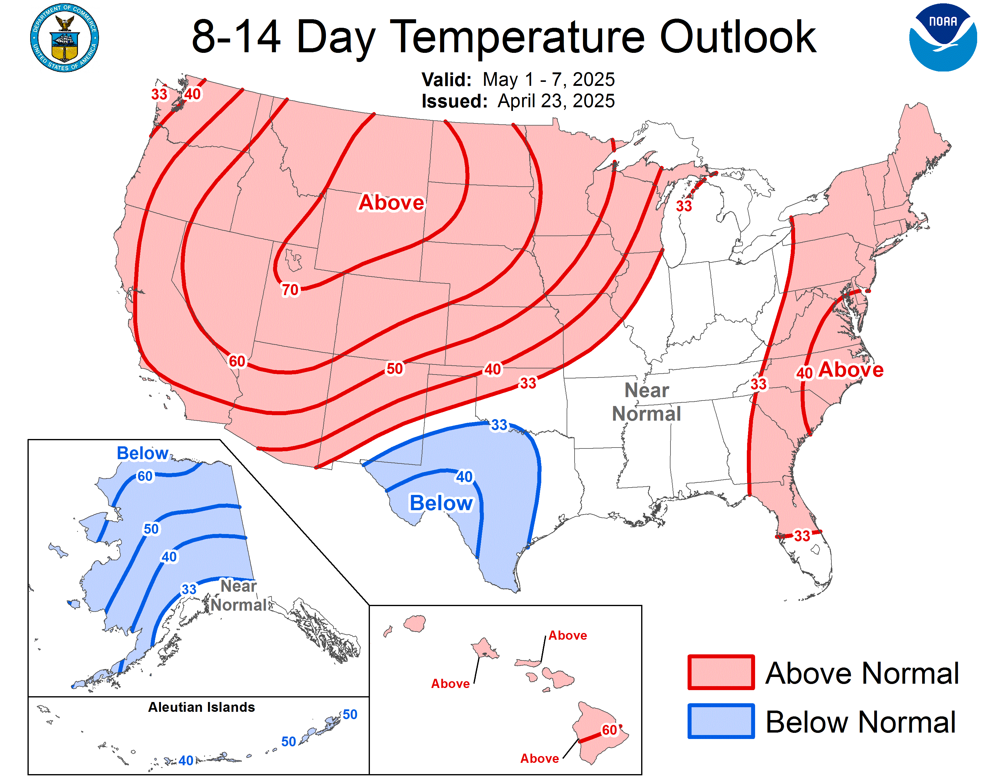
This is what the NCEP predicts for temperatures in the 8-14 day period.

Pretty emphatic about warmth out West...

Image
0 likes   

User avatar
R-Dub
Category 5
Category 5
Posts: 1427
Joined: Thu Dec 30, 2004 2:18 pm
Location: Stanwood, WA
Contact:

#2897 Postby R-Dub » Tue Mar 01, 2005 9:57 pm

Stevens Pass has the lowest snowpack for March 1st EVER!!!!
White pass is 0% of normal!! NO SNOW!!!
Baker is at 23% of normal.

Incredible stuff. I do though have a good feeling that things will be back to normal next winter.

Also its been so long now since a "classic" lowland windstorm that when we finally get another one, there will be MAJOR damage. New growth on the trees that have never seen a major wind will cause big problems.
I really miss those howling south winds that would gust 60+ MPH!! Just something about that sound!! :lol:

Hope we get really warm next week, though I will be in Moses Lake for most of next week, probably won't be quite as warm there.

Current temp 49.0 degrees and mostly cloudy
0 likes   

User avatar
R-Dub
Category 5
Category 5
Posts: 1427
Joined: Thu Dec 30, 2004 2:18 pm
Location: Stanwood, WA
Contact:

#2898 Postby R-Dub » Tue Mar 01, 2005 10:14 pm

Snipit from NWS, I know snowwiz will get mad at me for saying this :lol: , but that just sounds so good! If I was in town I would be out on the lake for sure!!

AREA FORECAST DISCUSSION NATIONAL WEATHER SERVICE SEATTLE WA 300 PM PST TUE MAR 1 2005

ALL GLOBAL MODELS SHOW THE RIDGE TO STRENGTHEN EVEN MORE EARLY NEXT WEEK...WITH POSSIBLY THE WARMEST DAYS SO FAR THIS YEAR. UPPER HEIGHTS SUGGEST MID 60S CERTAINLY ATTAINABLE...BUT HAVE ONLY NUDGED UP CLOSE TO 60 FOR NOW GIVEN THIS IS WAY OUT IN EXTENDED LAND. LOOKS LIKE A STRING OF NICE WEATHER DAYS ON THE WAY! &&
0 likes   

User avatar
R-Dub
Category 5
Category 5
Posts: 1427
Joined: Thu Dec 30, 2004 2:18 pm
Location: Stanwood, WA
Contact:

#2899 Postby R-Dub » Tue Mar 01, 2005 10:21 pm

Forecast for Moses Lake, about the same as here, maybe I will take my jetski over there and have some fun on that lake. Very unusual to have temps the same on the east side of the cascades as the west for the first part of March. Usually that doesn't happen until the first of April!!

Saturday through Monday
Mostly clear. Highs in the 50s to lower 60s. Lows in the 20s to upper 30s.

Monday Night
Partly cloudy. Lows in the 30s.

Tuesday
Mostly sunny. Highs in the 50s to mid 60s.

Here is the forecast for Everett for the same period.......

Saturday Night through Tuesday
Mostly clear. Lows near 40. Highs in the mid 50s to lower 60s.
0 likes   

andycottle
Category 5
Category 5
Posts: 1139
Joined: Thu Jan 06, 2005 11:34 pm
Location: Woodinville, Wa

#2900 Postby andycottle » Tue Mar 01, 2005 10:37 pm

Good evening all. A fairly nice day today after a kinda cloudy sky early this morning. From about late morning through late afternoon, skies were partly cloudy but then became overcast by early evening. Our high today was 63 with a low of 44 and .08" of precip over last 12hrs.

Here are some pics I took while at work today. Pretty neat cirrus clouds I`d say!

http://pg.photos.yahoo.com/ph/ajc192004 ... .dir=/8de4

-- Andy
0 likes   


Return to “Winter Weather”

Who is online

Users browsing this forum: No registered users and 51 guests