NOAA leaves same track map for 2005 season

This is the general tropical discussion area. Anyone can take their shot at predicting a storms path.

Moderator: S2k Moderators

Forum rules

The posts in this forum are NOT official forecasts and should not be used as such. They are just the opinion of the poster and may or may not be backed by sound meteorological data. They are NOT endorsed by any professional institution or STORM2K. For official information, please refer to products from the National Hurricane Center and National Weather Service.

Help Support Storm2K
Message
Author
User avatar
cycloneye
Admin
Admin
Posts: 148503
Age: 69
Joined: Thu Oct 10, 2002 10:54 am
Location: San Juan, Puerto Rico

NOAA leaves same track map for 2005 season

#1 Postby cycloneye » Wed Mar 23, 2005 6:17 pm

NOAA'S NATIONAL WEATHER SERVICE TO CONTINUE
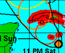
EXISTING TRACK MAP FOR TROPICAL CYCLONES


NOAA's National Hurricane Center will continue to use its existing track map for hurricanes, tropical storms and tropical depressions during the 2005 Atlantic Hurricane Season. Results of a recent online survey on proposed changes to the track map show the majority of respondents prefer to maintain the current format.


Image

http://www.nhc.noaa.gov/NOAA-PR-TCgraphics.shtml

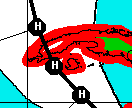
Read the rest of the information about the leaving the same grafic tracks at link above.I prefer the one with the circules.

Image
Last edited by cycloneye on Sun Mar 27, 2005 6:49 pm, edited 2 times in total.
0 likes   

Seele
Tropical Storm
Tropical Storm
Posts: 143
Joined: Wed Sep 08, 2004 9:14 pm
Location: Atlanta, GA

#2 Postby Seele » Wed Mar 23, 2005 6:43 pm

I preferred the circles too as I think it's a clearer representation of what is forecasted for the storm, but in the end, I don't think it makes too much of a difference. No matter which way you show the cone many people on the edges of the cone will always take the storm less seriously. Same reason many people will wait until the last possible day to evacuate. It's human nature to both not want their life disturbed if there's a chance the storm will miss and to think that it will not hit them.
0 likes   

User avatar
mobilebay
Category 5
Category 5
Posts: 1853
Age: 51
Joined: Wed Aug 18, 2004 1:22 am
Location: Mobile, Alabama

#3 Postby mobilebay » Thu Mar 24, 2005 3:09 am

I'm glad they left it alone. I'm tired of the Media faulting the NHC every time a storm misses landfall projection by a few miles. Fact is, The media is at fault for the Charley mess up. They was determined that it was going to strike Tampa. That would be their "big story".
0 likes   

Derek Ortt

#4 Postby Derek Ortt » Thu Mar 24, 2005 8:43 am

the Norcrosse seminar a few weeks ago showed just how rediculous the circles are. The map becomes totally unreadable for slow moving cyclones and is still quite confusing due to overlapping circles for faster ones
0 likes   

User avatar
HouTXmetro
Category 5
Category 5
Posts: 3949
Joined: Sun Jun 13, 2004 6:00 pm
Location: District of Columbia, USA

#5 Postby HouTXmetro » Thu Mar 24, 2005 11:40 am

I still think they should get rid of the straight lines. I'd prefer a color coded projection track which uses percentage strike probabilitys of 50% and greater.
0 likes   
[Disclaimer: My Amateur Opinion, please defer to your local authorities or the NHC for Guidance.]

User avatar
KWT
Category 5
Category 5
Posts: 31416
Joined: Tue Aug 17, 2004 11:02 am
Location: UK!!!

#6 Postby KWT » Thu Mar 24, 2005 1:16 pm

I think the new system is okay,although the old one is also very good i do probably prefer the new one as it just looks more neater to me then the old style.
0 likes   


Return to “Talkin' Tropics”

Who is online

Users browsing this forum: Google [Bot] and 677 guests