Yet another severe weather outbreak in the South Wed/Thur

U.S. & Caribbean Weather Discussions and Severe Weather Events

Moderator: S2k Moderators

Forum rules

The posts in this forum are NOT official forecast and should not be used as such. They are just the opinion of the poster and may or may not be backed by sound meteorological data. They are NOT endorsed by any professional institution or STORM2K.

Help Support Storm2K
Message
Author
Brent
S2K Supporter
S2K Supporter
Posts: 38094
Age: 37
Joined: Sun May 16, 2004 10:30 pm
Location: Tulsa Oklahoma
Contact:

Yet another severe weather outbreak in the South Wed/Thur

#1 Postby Brent » Tue Mar 29, 2005 9:26 am

:eek: :eek: :eek:

Image

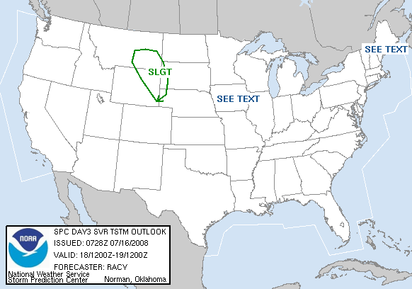
...OK/ERN TX ACROSS THE LWR MS VLY...
A CLUSTER OF STRONG STORMS MAY BE ONGOING EARLY IN THE PERIOD NEAR
THE CENTER OF THE DEEPENING CYCLONE OVER OK. PRONOUNCED FORCING FOR
ASCENT ON THE NOSE OF MID LEVEL WIND MAX WILL PROCEED EWD AND BEGIN
TO ACT ON VERY UNSTABLE AIRMASS OVER SERN OK/NRN TX BY AFTERNOON.
LATEST INDICATIONS ARE THAT WIDESPREAD CONVECTION WILL ALSO DEVELOP
EWD ALONG THE WARM FRONT WHERE SHEAR PROFILES WILL LIKELY SUPPORT
SUPERCELLS...SOME POTENTIALLY LONG TRACK.
ADDITIONAL DISCRETE STORMS
WILL BE POSSIBLE THROUGHOUT THE WARM SECTOR GIVEN FCST INSTABILITY
AND MAGNITUDE OF ASCENT DEVELOPING EAST ACROSS THE AREA AND AIDING
IN EROSION OF CAPPING INVERSION. LARGE HAIL...DAMAGING WINDS...AND
TORNADOES ALL APPEAR POSSIBLE GIVEN FCST PATTERN AND TIME OF YEAR.
AN INCREASE IN SEVERE WEATHER PROBABILITIES...AND AN UPGRADE TO MDT
RISK...WILL LIKELY OCCUR IN LATER OUTLOOKS AS FCST DETAILS BECOME
BETTER DEFINED.


:eek: :eek: :eek:
0 likes   
#neversummer

User avatar
JuliannaMKH
Tropical Depression
Tropical Depression
Posts: 71
Age: 51
Joined: Fri Sep 10, 2004 9:49 am
Location: Alabama
Contact:

#2 Postby JuliannaMKH » Tue Mar 29, 2005 10:45 am

I guess it was so much fun on Sunday that we need to do it all over again. :roll:
0 likes   

Brent
S2K Supporter
S2K Supporter
Posts: 38094
Age: 37
Joined: Sun May 16, 2004 10:30 pm
Location: Tulsa Oklahoma
Contact:

#3 Postby Brent » Tue Mar 29, 2005 11:01 am

JuliannaMKH wrote:I guess it was so much fun on Sunday that we need to do it all over again. :roll:


We were VERY lucky Sunday. No confirmed tornadoes(the Montgomery damage was from wind). Considering we were under a PDS Watch for over 24 hours straight(outside of a window early Sunday), I'm amazed we didn't have violent tornadoes with deaths and injuries.
0 likes   
#neversummer

OklahomaWeather
Professional-Met
Professional-Met
Posts: 206
Joined: Wed Aug 18, 2004 6:53 am
Location: Plano, Texas

#4 Postby OklahomaWeather » Tue Mar 29, 2005 11:09 am

Ohhh let it extend a little bit more northwest to REALLY include me!!! :D
0 likes   

User avatar
Skywatch_NC
Category 5
Category 5
Posts: 10949
Joined: Wed Feb 05, 2003 9:31 pm
Location: Raleigh, NC
Contact:

#5 Postby Skywatch_NC » Tue Mar 29, 2005 12:59 pm

Looks like the Great Lakes and Ohio Valley are under the gun for Wednesday, too.

Another chance for thunderstorms here in NC come Friday and Friday night.

Eric
0 likes   

User avatar
JuliannaMKH
Tropical Depression
Tropical Depression
Posts: 71
Age: 51
Joined: Fri Sep 10, 2004 9:49 am
Location: Alabama
Contact:

#6 Postby JuliannaMKH » Tue Mar 29, 2005 1:19 pm

I agree. We were extrodinarily lucky that the situation wasn't much worse and there was no loss of life. I had heard that the investigation indicated the damage in east Montgomery was from straight line winds. I know on WSFA's Sunday night newscast they showed some brief footage of a tornado from the Deer Creek subdivision. It must not have caused any damage and that's a good thing.

I get twichy sometimes about severe weather on work days. The building I work in was lucky to survive Ivan and it has some roofing and drainage issues. There is really no where to go but outside in the ditch if the sky starts dropping tornados on us.
0 likes   

User avatar
Brett Adair
Category 1
Category 1
Posts: 322
Joined: Sun Apr 11, 2004 8:49 pm
Location: Sylacauga, Alabama
Contact:

#7 Postby Brett Adair » Tue Mar 29, 2005 3:38 pm

I believe that they are on target with this next system. Looks as if moisture values across my region in Alabama will be prime for some severe weather this event. Also, the warm frontal zone will be just a bit further north which will leave much of the area in the warm sector with deepening low pressure across TN by late Thursday. Looks as if some significant tornadoes will be possible with this system. I am willing to bet this system won't be a bustola....I would say if you live in AR/LA/MS/AL/TN/GA/NC/SC go over your tornado safety plans NOW!
0 likes   

jeff
Professional-Met
Professional-Met
Posts: 831
Joined: Sun Sep 12, 2004 6:14 pm
Location: Houston, TX
Contact:

#8 Postby jeff » Tue Mar 29, 2005 6:19 pm

Looks a little questionable on instability and low level shear for tornadoes. May see more of a large hail and wind threat
0 likes   


Return to “USA & Caribbean Weather”

Who is online

Users browsing this forum: Google Adsense [Bot], Greener, South Texas Storms, txtwister78 and 14 guests