Two important updates about ENSO this week (Wed,Thur)

This is the general tropical discussion area. Anyone can take their shot at predicting a storms path.

Moderator: S2k Moderators

Forum rules

The posts in this forum are NOT official forecasts and should not be used as such. They are just the opinion of the poster and may or may not be backed by sound meteorological data. They are NOT endorsed by any professional institution or STORM2K. For official information, please refer to products from the National Hurricane Center and National Weather Service.

Help Support Storm2K
Message
Author
User avatar
cycloneye
Admin
Admin
Posts: 148503
Age: 69
Joined: Thu Oct 10, 2002 10:54 am
Location: San Juan, Puerto Rico

Two important updates about ENSO this week (Wed,Thur)

#1 Postby cycloneye » Fri Apr 29, 2005 4:53 pm

Image

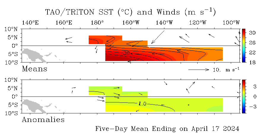
On May 4 the Aussies will issue their update for ENSO and on May 5 NOAA will do the same.What will they say about the warming at el nino 1-2 as grafics show? We will find out next week.These May updates are important as the hurricane season is almost around the corner and this factor is the most important one to evaluate about how the season will be in terms of activity.
Image
Last edited by cycloneye on Mon May 02, 2005 5:15 pm, edited 2 times in total.
0 likes   

User avatar
wxman57
Moderator-Pro Met
Moderator-Pro Met
Posts: 23080
Age: 68
Joined: Sat Jun 21, 2003 8:06 pm
Location: Houston, TX (southwest)

#2 Postby wxman57 » Fri Apr 29, 2005 5:36 pm

What we're seeing in the eastern Pacific is warming associated with an eastward-moving Kelvin wave/westerly wind burst. The warm pocket is VERY shallow, depth-wise. Below that warm surface water is a large pocket of much cooler than normal water. This cooler water is upwelling in the wake of the Kelvin wave in Nino 3/4, causing temps to drop there.

This is a very different scenario from the recent 1997 El Nino year which had a very deep sub-surface warm pocket in April (vs. cold water just below the surface in April '05). I have a loop of SSTs from Feb 1 through about April 26 which clearly shows the SSTs warming from west to east, followed by significant cooling from west to east in the wake of the Kelvin wave.

So it looks like the eastern Pacific warming is only going to be temporary. Cooler SSTs should return in May, with neutral conditions across the Pacific for hurricane season.

<img src="http://myweb.cableone.net/nolasue/ssts.gif">
0 likes   

rainstorm

#3 Postby rainstorm » Fri Apr 29, 2005 5:37 pm

hard to say
0 likes   

LarryWx
S2K Supporter
S2K Supporter
Posts: 6853
Joined: Sun Sep 07, 2003 2:04 pm
Location: GA

#4 Postby LarryWx » Fri Apr 29, 2005 5:46 pm

I'm sticking with either a weak El Nino or neutral for my prediction. Based on data from seasons going back to 1950, my take is that either would produce about the same # of storms.
So, which one it ends up being wouldn't matter too much imo.
0 likes   
Personal Forecast Disclaimer:
The posts in this forum are NOT official forecasts and should not be used as such. They are just the opinion of the poster and may or may not be backed by sound meteorological data. They are NOT endorsed by any professional institution or storm2k.org. For official information, please refer to the NHC and NWS products.

User avatar
cycloneye
Admin
Admin
Posts: 148503
Age: 69
Joined: Thu Oct 10, 2002 10:54 am
Location: San Juan, Puerto Rico

#5 Postby cycloneye » Fri Apr 29, 2005 5:50 pm

My prediction (Read it at Tropical Analysis forum) for a very weak el nino early in the season to neutral at the peak by august and september will stay put.I know that some are nervous about those yellows at the grafics above but I agree with wxman57 it will be a temporary event.
0 likes   
Visit the Caribbean-Central America Weather Thread where you can find at first post web cams,radars
and observations from Caribbean basin members Click Here

User avatar
cycloneye
Admin
Admin
Posts: 148503
Age: 69
Joined: Thu Oct 10, 2002 10:54 am
Location: San Juan, Puerto Rico

#6 Postby cycloneye » Sat Apr 30, 2005 5:52 am

LarryWx wrote:I'm sticking with either a weak El Nino or neutral for my prediction. Based on data from seasons going back to 1950, my take is that either would produce about the same # of storms.
So, which one it ends up being wouldn't matter too much imo.


I agree wth your statement.
0 likes   
Visit the Caribbean-Central America Weather Thread where you can find at first post web cams,radars
and observations from Caribbean basin members Click Here

User avatar
x-y-no
Category 5
Category 5
Posts: 8359
Age: 65
Joined: Wed Aug 11, 2004 12:14 pm
Location: Fort Lauderdale, FL

#7 Postby x-y-no » Sat Apr 30, 2005 9:43 am

I agree. There just isn't enough energy there to flip us into an el Nino. We're looking at neutral conditions for the bulk of the season, IMHO.
0 likes   

cyclonaut

#8 Postby cyclonaut » Sat Apr 30, 2005 10:51 am

Yeah I agree too.If there is a El Nino it will be the weakest most insignificant thing you can imagine.
0 likes   

User avatar
cycloneye
Admin
Admin
Posts: 148503
Age: 69
Joined: Thu Oct 10, 2002 10:54 am
Location: San Juan, Puerto Rico

#9 Postby cycloneye » Sun May 01, 2005 5:57 pm

It looks a bit more yellow at el nino 1-2 and in part of el nino 3 as above grafics show.However the warming has peaked as the warm Kelvin wave is getting smaller as time goes by.But there are cool anomalys behind at el nino 4 and those will spread eastward with time.

Image
0 likes   
Visit the Caribbean-Central America Weather Thread where you can find at first post web cams,radars
and observations from Caribbean basin members Click Here

donsutherland1
S2K Analyst
S2K Analyst
Posts: 2718
Joined: Mon Sep 15, 2003 8:49 pm
Location: New York

Re: Two important updates about ENSO this week

#10 Postby donsutherland1 » Mon May 02, 2005 9:58 am

Luis,

I'll certainly be interested in these updates. The warming has now become much more pronounced in the eastern Pacific (Regions 1+2 and 3) than in the past few weeks. However, the rate of warming has slowed farther west (Regions 3.4 and 4).

Changes in Regional Anomalies from the Previous Week:

• Region 1+2:
Week of April 20: +0.4°C
Week of April 27: +0.8°C (now a +0.4°C anomaly)

• Region 3:
Week of April 20: +0.3°C
Week of April 27: +0.3°C (now a +0.9°C anomaly)

• Region 3.4:
Week of April 20: +0.3°C
Week of April 27: +0.1°C (now a +0.6°C anomaly)

• Region 4:
Week of April 20: +0.1°C
Week of April 27: +0.1°C (now a +0.6°C anomaly)
0 likes   

StormChasr

#11 Postby StormChasr » Mon May 02, 2005 11:46 am

There's gonna be a Nino, and it wil suprise a lot of people with its intensity--nothing like 1997, but fairly strong. Also, look at the ENSO forecasts based on models for 2005. They show a trend of extremely warm Carribbean water, but sub-normal water on the ATL Eastern Seaboard, expecially all around Florida.
0 likes   

User avatar
cycloneye
Admin
Admin
Posts: 148503
Age: 69
Joined: Thu Oct 10, 2002 10:54 am
Location: San Juan, Puerto Rico

Re: Two important updates about ENSO this week

#12 Postby cycloneye » Mon May 02, 2005 1:59 pm

donsutherland1 wrote:Luis,

I'll certainly be interested in these updates. The warming has now become much more pronounced in the eastern Pacific (Regions 1+2 and 3) than in the past few weeks. However, the rate of warming has slowed farther west (Regions 3.4 and 4).

Changes in Regional Anomalies from the Previous Week:

• Region 1+2:
Week of April 20: +0.4°C
Week of April 27: +0.8°C (now a +0.4°C anomaly)

• Region 3:
Week of April 20: +0.3°C
Week of April 27: +0.3°C (now a +0.9°C anomaly)

• Region 3.4:
Week of April 20: +0.3°C
Week of April 27: +0.1°C (now a +0.6°C anomaly)

• Region 4:
Week of April 20: +0.1°C
Week of April 27: +0.1°C (now a +0.6°C anomaly)


That warming at el nino 1-2 is temporary don.You will see things cool slowly there very soon.
0 likes   
Visit the Caribbean-Central America Weather Thread where you can find at first post web cams,radars
and observations from Caribbean basin members Click Here

User avatar
x-y-no
Category 5
Category 5
Posts: 8359
Age: 65
Joined: Wed Aug 11, 2004 12:14 pm
Location: Fort Lauderdale, FL

#13 Postby x-y-no » Mon May 02, 2005 2:04 pm

StormChasr wrote:There's gonna be a Nino, and it wil suprise a lot of people with its intensity--nothing like 1997, but fairly strong. Also, look at the ENSO forecasts based on models for 2005. They show a trend of extremely warm Carribbean water, but sub-normal water on the ATL Eastern Seaboard, expecially all around Florida.


We'll see ...

I'm still firmly in the "el Nino skeptics" camp. :-)
0 likes   

Scorpion

#14 Postby Scorpion » Mon May 02, 2005 2:51 pm

Odd that noone but StormChasr thinks there will be a strong Nino. Where is the Kelvin wave to produce it? Waters are cool behind the warming areas, and the warming is only temporary.
0 likes   

User avatar
James
Category 5
Category 5
Posts: 1531
Joined: Tue Aug 24, 2004 10:29 am
Location: Gloucestershire, England
Contact:

#15 Postby James » Mon May 02, 2005 2:54 pm

Yea, it does seem that an El Nino may not materialise. I don't pretend to know a huge amount about the workings of it all, but based on the available evidence and what others have said, I think I shall sit myself down in the skeptics lounge for now.
0 likes   

cyclonaut

#16 Postby cyclonaut » Mon May 02, 2005 2:59 pm

I dont see a moderate to strong El Nino anywhere in the near future.

Weak......possibly???
0 likes   

StormChasr

#17 Postby StormChasr » Mon May 02, 2005 5:40 pm

Look at Cycloneye's charts and see the latest one above. The Kelvin wave not only raised the EPAC temps considerably, there is abnormally warm water behind---so there will be a Nino (in my unhumble opinion). I've been the only one advocating a position before--when the NHC was forecasting a "right angle turn" for Frances into Daytona Beach, I knew that was absurd, extremely improbable, and was simply NOT going to happen, and I made my feelings known. :wink:
0 likes   

User avatar
cycloneye
Admin
Admin
Posts: 148503
Age: 69
Joined: Thu Oct 10, 2002 10:54 am
Location: San Juan, Puerto Rico

#18 Postby cycloneye » Mon May 02, 2005 6:05 pm

Image

Above is the grafic that is making many people nervous as those yellows and even a little bit of orange show up at parts of el nino 3 and at the 1-2 area.But I am not one of those nervous ones. :)
0 likes   

User avatar
canegrl04
Category 5
Category 5
Posts: 2486
Joined: Thu Aug 26, 2004 5:37 pm
Location: Texas

#19 Postby canegrl04 » Mon May 02, 2005 9:10 pm

I used to be leaning toward el nino.Now after this report,I believe weak el nino at the most.The Atlantic will be on fire this season :eek:
0 likes   

donsutherland1
S2K Analyst
S2K Analyst
Posts: 2718
Joined: Mon Sep 15, 2003 8:49 pm
Location: New York

Re: Two important updates about ENSO this week

#20 Postby donsutherland1 » Mon May 02, 2005 11:17 pm

Luis,

I fully agree. Already, the warming has slowed in the western Pacific. I'm expecting neutral ENSO conditions for the July-August period and probably for most--perhaps all--of the upcoming hurricane season.
0 likes   


Return to “Talkin' Tropics”

Who is online

Users browsing this forum: chaser1 and 525 guests