Yikes!! Goodbye to Yellows,Hello to Blues at Pacific

This is the general tropical discussion area. Anyone can take their shot at predicting a storms path.

Moderator: S2k Moderators

Forum rules

The posts in this forum are NOT official forecasts and should not be used as such. They are just the opinion of the poster and may or may not be backed by sound meteorological data. They are NOT endorsed by any professional institution or STORM2K. For official information, please refer to products from the National Hurricane Center and National Weather Service.

Help Support Storm2K
Message
Author
User avatar
cycloneye
Admin
Admin
Posts: 148503
Age: 69
Joined: Thu Oct 10, 2002 10:54 am
Location: San Juan, Puerto Rico

Yikes!! Goodbye to Yellows,Hello to Blues at Pacific

#1 Postby cycloneye » Mon May 09, 2005 4:37 pm

Image

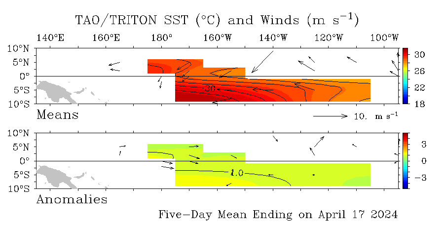
Yes there are a few yellow colors but what a change from the past 3 weeks where very bright yellows or warm +3.0c were at el nino 1-2 and parts of 3 but look now how it is cooling again at el nino 1-2 .Well folks prepare for another active season without el nino.And further back at el nino 4 near the dateline there are no warm waters around.

Mark Sudduth I guess your team will have plenty of work in 2005. :)
Last edited by cycloneye on Sat May 14, 2005 7:20 pm, edited 6 times in total.
0 likes   

Scorpion

#2 Postby Scorpion » Mon May 09, 2005 4:39 pm

Good :D. Wow, we got some really cold water in the GOM and off the coast. Hopefully we'll have a really hot summer to warm those up.
0 likes   

User avatar
Wpwxguy
S2K Supporter
S2K Supporter
Posts: 427
Joined: Sun Sep 12, 2004 2:10 pm
Location: Southeast Louisiana
Contact:

#3 Postby Wpwxguy » Mon May 09, 2005 4:57 pm

I don't think we'll have a problem warming those cool waters in the Gulf and East Coast areas, by mid June I think temps will at least be at normal values. Good bye El Nino. Hello headaches for Florida and Gulf Coast, just my opinion.


Bill
0 likes   

User avatar
x-y-no
Category 5
Category 5
Posts: 8359
Age: 65
Joined: Wed Aug 11, 2004 12:14 pm
Location: Fort Lauderdale, FL

#4 Postby x-y-no » Mon May 09, 2005 5:00 pm

Yep ...

I got a little nervous there for a week or so, but I'm glad I stuck to my guns on predicting a neutral season. :-)

Jan
0 likes   

User avatar
cycloneye
Admin
Admin
Posts: 148503
Age: 69
Joined: Thu Oct 10, 2002 10:54 am
Location: San Juan, Puerto Rico

#5 Postby cycloneye » Mon May 09, 2005 5:02 pm

x-y-no wrote:Yep ...

I got a little nervous there for a week or so, but I'm glad I stuck to my guns on predicting a neutral season. :-)

Jan


I was tranquil as I knew that Kelvin wave was not enough to trigger an el nino.And the most important thing is that no other strong Kelvin waves are seen moving eastward at this time.
0 likes   
Visit the Caribbean-Central America Weather Thread where you can find at first post web cams,radars
and observations from Caribbean basin members Click Here

User avatar
cycloneye
Admin
Admin
Posts: 148503
Age: 69
Joined: Thu Oct 10, 2002 10:54 am
Location: San Juan, Puerto Rico

#6 Postby cycloneye » Mon May 09, 2005 5:31 pm

Image

August 1997

This is what you can say is a real el nino this grafic at August 6 1997. Compare it with the grafic at first post and there is a huge difference.
0 likes   
Visit the Caribbean-Central America Weather Thread where you can find at first post web cams,radars
and observations from Caribbean basin members Click Here

Scorpion

#7 Postby Scorpion » Mon May 09, 2005 5:38 pm

Lol wow. I would have a heart attack if i saw that again.
0 likes   

cyclonaut

#8 Postby cyclonaut » Mon May 09, 2005 9:17 pm

That El Nino was El meano!
0 likes   

Matt-hurricanewatcher

#9 Postby Matt-hurricanewatcher » Mon May 09, 2005 9:23 pm

That would be something if the Gulf of Mexico turns around in shoots its seasurface temperatures into the 90s or lower 100s. While the Caribbean goe's into the 90s. The rest of the central tropical Atlatnic with the Eastern Atlantic up into the mid 80s.

That would make hurricanes very fast. Heck I would not sleep for weeks. :lol:
0 likes   

Scorpion

#10 Postby Scorpion » Mon May 09, 2005 9:35 pm

Has there ever been SST's above 100 degrees? That would be insane!! Too hot to swim in!
0 likes   

cyclonaut

#11 Postby cyclonaut » Mon May 09, 2005 9:50 pm

I believe the highest ever recorded is low 90s.
0 likes   

User avatar
hurricanetrack
HurricaneTrack.com
HurricaneTrack.com
Posts: 1781
Joined: Tue Dec 02, 2003 10:46 pm
Location: Wilmington, NC
Contact:

El Nino defined

#12 Postby hurricanetrack » Mon May 09, 2005 10:24 pm

El Nino is Spanish for "No hurricanes for YOU!"
:lol:
0 likes   

StormChasr

#13 Postby StormChasr » Tue May 10, 2005 1:55 pm

Look more carefullly at the charts. I would not rule out an El Nino....nothing like the '97 one, but look at the Atlantic.....cool water still predominates in the central ATL, and even off the coast of Africa. Plenty of time for more "red" in the Pacific, and I think there will be lots of surprises in the comparable August maps.
0 likes   

cyclonaut

#14 Postby cyclonaut » Tue May 10, 2005 2:08 pm

Good to see that your sticking to your original thought but I don't know where this El Nino is going to come from.

Also where off the coast of Africa is the cool water you speak of,if its the cool water south of the equator thats really not a problem.If there was cool water there its only May so its irrelevent anyway.
0 likes   

StormChasr

#15 Postby StormChasr » Tue May 10, 2005 2:16 pm

Let's wait and see. :)
0 likes   

User avatar
cycloneye
Admin
Admin
Posts: 148503
Age: 69
Joined: Thu Oct 10, 2002 10:54 am
Location: San Juan, Puerto Rico

#16 Postby cycloneye » Tue May 10, 2005 2:23 pm

Image

Another grafic that shows how the warm waters that haved been in the el nino 1-2 and part of el nino 3 haved been cooling slowly as the last strong Kelvin Wave has made it's effect and now cooler waters are returning to these areas.Waters as far warm as +3.0c where there in the past 3 weeks but now those readings haved commed down to +1.0c.Note that at el nino 3-4 no warm waters are noted as no other strong Kelvin Waves are in sight in the near future.
Last edited by cycloneye on Thu May 12, 2005 4:38 pm, edited 1 time in total.
0 likes   
Visit the Caribbean-Central America Weather Thread where you can find at first post web cams,radars
and observations from Caribbean basin members Click Here

User avatar
x-y-no
Category 5
Category 5
Posts: 8359
Age: 65
Joined: Wed Aug 11, 2004 12:14 pm
Location: Fort Lauderdale, FL

#17 Postby x-y-no » Tue May 10, 2005 2:31 pm

Fairly strong easterly wind anomaly across the whole basin - with no significant follow-on kelvin wave in evidence, that means it isn't going to happen until at least the next MJO cycle, and that'll be too late to stop the reestablishment of the cool anomaly in nino1/2 (which is already showing signs of coming back).

Jan
0 likes   

User avatar
cycloneye
Admin
Admin
Posts: 148503
Age: 69
Joined: Thu Oct 10, 2002 10:54 am
Location: San Juan, Puerto Rico

#18 Postby cycloneye » Wed May 11, 2005 3:29 pm

The trend continues towards less warm anomalys today May 11th in the el nino 1-2 and el nino 3-4 areas with temps less than the area of el nino values.

Image
0 likes   
Visit the Caribbean-Central America Weather Thread where you can find at first post web cams,radars
and observations from Caribbean basin members Click Here

User avatar
cycloneye
Admin
Admin
Posts: 148503
Age: 69
Joined: Thu Oct 10, 2002 10:54 am
Location: San Juan, Puerto Rico

#19 Postby cycloneye » Thu May 12, 2005 4:51 pm

Less and less yellows are showing up at the may 12th grafic in the equatorial pacific.The discussion about having el nino during the 2005 hurricane season is over.
0 likes   
Visit the Caribbean-Central America Weather Thread where you can find at first post web cams,radars
and observations from Caribbean basin members Click Here

User avatar
cycloneye
Admin
Admin
Posts: 148503
Age: 69
Joined: Thu Oct 10, 2002 10:54 am
Location: San Juan, Puerto Rico

#20 Postby cycloneye » Fri May 13, 2005 4:55 pm

Blue colors or cooler anomalys are expanding westward at el nino 1-2 into el nino 3 meaning nothing that may wake up el nino is around.
0 likes   
Visit the Caribbean-Central America Weather Thread where you can find at first post web cams,radars
and observations from Caribbean basin members Click Here


Return to “Talkin' Tropics”

Who is online

Users browsing this forum: Google Adsense [Bot], Teban54 and 379 guests