Possible new EPAC Invest

This is the general tropical discussion area. Anyone can take their shot at predicting a storms path.

Moderator: S2k Moderators
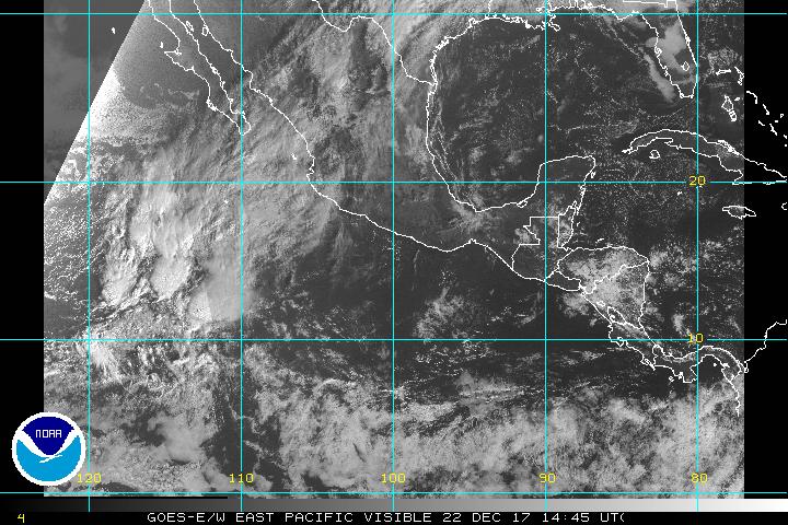
Forum rules

The posts in this forum are NOT official forecasts and should not be used as such. They are just the opinion of the poster and may or may not be backed by sound meteorological data. They are NOT endorsed by any professional institution or STORM2K. For official information, please refer to products from the National Hurricane Center and National Weather Service.

Help Support Storm2K
Message
Author
User avatar
gatorcane
S2K Supporter
S2K Supporter
Posts: 23703
Age: 47
Joined: Sun Mar 13, 2005 3:54 pm
Location: Boca Raton, FL

Possible new EPAC Invest

#1 Postby gatorcane » Thu May 19, 2005 7:42 pm

Check out what's brewing out at about 107 degrees longitude...
:eek:

[url]
http://www.ssd.noaa.gov/PS/TROP/DATA/RT/EPAC/VIS/20.jpg
[/url]
0 likes   

Coredesat

#2 Postby Coredesat » Thu May 19, 2005 7:53 pm

Looks like a flare-up of convection in the ITCZ to me. I don't see any circulation, and there's no mention of it in any advisories I can find.

EDIT:

...ITCZ...

ITCZ AXIS IS CENTERED ALONG 10N88W 7N100W 7N120W 5N130W
6N140W. SCATTERED MODERATE ISOLATED STRONG WITHIN 60 NM OF
LINE 10N89W 8N91W 6N94W. SCATTERED MODERATE ISOLATED STRONG
WITHIN 75 NM OF THE AXIS BETWEEN 104W-109W.
SCATTERED
MODERATE WITHIN A 45 NM RADIUS OF 6N127W.


Sounds like that's what this is.
Last edited by Coredesat on Thu May 19, 2005 7:57 pm, edited 1 time in total.
0 likes   

User avatar
ROCK
Category 5
Category 5
Posts: 9492
Age: 54
Joined: Tue Aug 17, 2004 7:30 am
Location: Kemah, Texas

Re: Possible new EPAC Invest

#3 Postby ROCK » Thu May 19, 2005 7:53 pm

boca_chris wrote:Check out what's brewing out at about 107 degrees longitude...
:eek:

[url]
http://www.ssd.noaa.gov/PS/TROP/DATA/RT/EPAC/VIS/20.jpg
[/url]


Looks decent enough. I bet its going to FL somehow....
0 likes   

User avatar
gatorcane
S2K Supporter
S2K Supporter
Posts: 23703
Age: 47
Joined: Sun Mar 13, 2005 3:54 pm
Location: Boca Raton, FL

#4 Postby gatorcane » Thu May 19, 2005 7:56 pm

there is actually a slight noticeable rotation...if it stays around tonight and through tomorrow, I would say it will be the second EPAC invest. Shear is not that strong in this area and water temps are warm.
0 likes   

User avatar
ROCK
Category 5
Category 5
Posts: 9492
Age: 54
Joined: Tue Aug 17, 2004 7:30 am
Location: Kemah, Texas

#5 Postby ROCK » Thu May 19, 2005 7:59 pm

boca_chris wrote:there is actually a slight noticeable rotation...if it stays around tonight and through tomorrow, I would say it will be the second EPAC invest. Shear is not that strong in this area and water temps are warm.


Seriously, Boca I think I can make out some rotation also. Something else to watch while we wait for the big show.
0 likes   

soonertwister
Category 5
Category 5
Posts: 1091
Joined: Mon Jun 16, 2003 2:52 pm

#6 Postby soonertwister » Thu May 19, 2005 8:42 pm

I noticed that thing about 4 this afternoon. It didn't look like just your average thunderstorm-type situation, but I blew it off. Now way do TWO Pacific tropical systems form and move east in the same season.

It's never happened in recorded history.
0 likes   

Matt-hurricanewatcher

#7 Postby Matt-hurricanewatcher » Thu May 19, 2005 8:44 pm

IF the Eastern Pacific systems are moving Eastward that means=Strong shear over the Atlatnic. So Less storms for the Atlantic. Kind of like we saw during 1997.
0 likes   

HurricaneBill
Category 5
Category 5
Posts: 3420
Joined: Sun Apr 11, 2004 5:51 pm
Location: East Longmeadow, MA, USA

#8 Postby HurricaneBill » Thu May 19, 2005 9:42 pm

soonertwister wrote:I noticed that thing about 4 this afternoon. It didn't look like just your average thunderstorm-type situation, but I blew it off. Now way do TWO Pacific tropical systems form and move east in the same season.

It's never happened in recorded history.


Well, hurricanes never moved eastward through the Caribbean like Lenny in 1999, yet that was an active season.
0 likes   

User avatar
gatorcane
S2K Supporter
S2K Supporter
Posts: 23703
Age: 47
Joined: Sun Mar 13, 2005 3:54 pm
Location: Boca Raton, FL

#9 Postby gatorcane » Fri May 20, 2005 7:41 am

I would expect advisories on this new EPAC invest today...it's looking impressive :eek:
0 likes   

User avatar
boca
Category 5
Category 5
Posts: 6400
Age: 61
Joined: Mon Dec 15, 2003 8:49 am
Location: Boca Raton,FL

#10 Postby boca » Fri May 20, 2005 8:44 am

Which way would this new invest go,would it follow adrian or move west into the open Pacific?
0 likes   

User avatar
dhweather
S2K Supporter
S2K Supporter
Posts: 6199
Joined: Sat Aug 14, 2004 9:29 pm
Location: Heath, TX
Contact:

#11 Postby dhweather » Fri May 20, 2005 8:45 am

I don't believe any advisories will be started today on this.

It's surrounded by really dry air, and with a trough to its NE and
NW, I don't expect much from it.
0 likes   

User avatar
gatorcane
S2K Supporter
S2K Supporter
Posts: 23703
Age: 47
Joined: Sun Mar 13, 2005 3:54 pm
Location: Boca Raton, FL

#12 Postby gatorcane » Fri May 20, 2005 9:01 am

Really, it's looking better by the hour on the satellite... :eek:
0 likes   

User avatar
gatorcane
S2K Supporter
S2K Supporter
Posts: 23703
Age: 47
Joined: Sun Mar 13, 2005 3:54 pm
Location: Boca Raton, FL

#13 Postby gatorcane » Fri May 20, 2005 9:03 am

I think we'll have our second depression of the EPAC season by the end of the day today. It has a circulation already and the convection has persisted for more than 24 hours.
0 likes   

User avatar
gatorcane
S2K Supporter
S2K Supporter
Posts: 23703
Age: 47
Joined: Sun Mar 13, 2005 3:54 pm
Location: Boca Raton, FL

#14 Postby gatorcane » Fri May 20, 2005 9:04 am

Disclaimer (for my above comment)^^

The following post is NOT an official forecast and should not be used as such. It is just the opinion of the poster and may or may not be backed by sound meteorological data. It is NOT endorsed by any professional institution including storm2k.org For Official Information please refer to the NHC and NWS products.
0 likes   

User avatar
gatorcane
S2K Supporter
S2K Supporter
Posts: 23703
Age: 47
Joined: Sun Mar 13, 2005 3:54 pm
Location: Boca Raton, FL

#15 Postby gatorcane » Fri May 20, 2005 9:43 am

Latest satellite pics of this possible new EPAC invest. It's looking very depression-like to me this morning. Nice persistent thunderstorm activity,
a noticeable rotation, and the environment is favorable:

[url]
http://www.ssd.noaa.gov/PS/TROP/DATA/RT ... -loop.html
[/url]
0 likes   

User avatar
boca
Category 5
Category 5
Posts: 6400
Age: 61
Joined: Mon Dec 15, 2003 8:49 am
Location: Boca Raton,FL

#16 Postby boca » Fri May 20, 2005 9:44 am

Which way would this system go once it forms?
0 likes   

User avatar
gatorcane
S2K Supporter
S2K Supporter
Posts: 23703
Age: 47
Joined: Sun Mar 13, 2005 3:54 pm
Location: Boca Raton, FL

#17 Postby gatorcane » Fri May 20, 2005 9:48 am

The following post is NOT an official forecast and should not be used as such. It is just the opinion of the poster and may or may not be backed by sound meteorological data. It is NOT endorsed by any professional institution including storm2k.org For Official Information please refer to the NHC and NWS products:

There's a trough to the NE and NW so it is nearly stationary right now with maybe a slight W drift. I don't think it will take Adrian's path though as the trough to the NE will be lifting out in the next couple of days. We should see TD #2 advisory shortly that will discuss more.
0 likes   

User avatar
dhweather
S2K Supporter
S2K Supporter
Posts: 6199
Joined: Sat Aug 14, 2004 9:29 pm
Location: Heath, TX
Contact:

#18 Postby dhweather » Fri May 20, 2005 9:52 am

It's just a nice clump of thunderstorms. Give it a few days and see what happens.
0 likes   

Brent
S2K Supporter
S2K Supporter
Posts: 38266
Age: 37
Joined: Sun May 16, 2004 10:30 pm
Location: Tulsa Oklahoma
Contact:

#19 Postby Brent » Fri May 20, 2005 9:58 am

and I'm sure it's headed towards South Florida right? :roll:
0 likes   
#neversummer

User avatar
Roxy
S2K Supporter
S2K Supporter
Posts: 657
Joined: Mon Aug 16, 2004 7:58 am
Location: Houston (Clear Lake)

#20 Postby Roxy » Fri May 20, 2005 10:21 am

Brent wrote:and I'm sure it's headed towards South Florida right? :roll:


:lol: :lol:
0 likes   


Return to “Talkin' Tropics”

Who is online

Users browsing this forum: Teban54 and 146 guests