It looks like a subtropical storm right now. Convection is starting to completely wrap around, and according to http://www.cira.colostate.edu/RAMM/gpar ... _loop.html there isn't a bad chance.
Just another something while we wait for June 1st.
32N/45W
Moderator: S2k Moderators
Forum rules

The posts in this forum are NOT official forecasts and should not be used as such. They are just the opinion of the poster and may or may not be backed by sound meteorological data. They are NOT endorsed by any professional institution or STORM2K. For official information, please refer to products from the National Hurricane Center and National Weather Service.
-
Hurricanehink

- S2K Supporter

- Posts: 2047
- Joined: Sun Nov 16, 2003 2:05 pm
- Location: New Jersey
32N/45W
0 likes

-
cycloneye

- Admin

- Posts: 148855
- Age: 69
- Joined: Thu Oct 10, 2002 10:54 am
- Location: San Juan, Puerto Rico
dhweather wrote:Woodja edit the link and remove the trailing comma please?
Gracias!
Done.
0 likes
Visit the Caribbean-Central America Weather Thread where you can find at first post web cams,radars
and observations from Caribbean basin members Click Here
and observations from Caribbean basin members Click Here
-
donsutherland1
- S2K Analyst

- Posts: 2718
- Joined: Mon Sep 15, 2003 8:49 pm
- Location: New York
Re: 32N/45W
Hurricanehink,
Since 1950, 12 tropical cyclones have developed at or north of 30°N and east of 50°W. None developed before July, with Hurricane Dorothy (1966) being the earliest such storm. Also, none of those storms developed with a blocking regime that is as strong as the current one.
So, the historical odds appear very much against this sytem's reaching tropical storm strength given its location, how early in the year it is, and the very strong block presently in place.
Nonetheless, this is an interesting situation to watch.
0 likes
-
Hurricanehink
- S2K Supporter
- Posts: 2047
- Joined: Sun Nov 16, 2003 2:05 pm
- Location: New Jersey
-
Matt-hurricanewatcher
The data going back only 150 years might be against it. But tell that to all of the storms that have broken that rule over the last year. I just got home so I will look into it. You really can't go by that short of time frame.
In remember we have not seen a tropical storm in May since Alison of 1981. Its about time.
In remember we have not seen a tropical storm in May since Alison of 1981. Its about time.
0 likes
-
donsutherland1
- S2K Analyst
- Posts: 2718
- Joined: Mon Sep 15, 2003 8:49 pm
- Location: New York
Matt-hurricanewatcher,
There are three things going against this storm's becoming a tropical cyclone:
1) historical odds
2) geographic location (SSTs)
3) synoptic situation (the very strong block)
The synoptic situation and SSTs are the biggest strikes against its development. The historical odds reflect just how difficult it is for such storms to become tropical. If one were looking for an exception to the historical odds, one would need to examine the synoptic environment. It is not favorable.
In contrast, the synoptic environment was unusually favorable for development with last year's rare south Atlantic hurricane that hit Brazil.
0 likes
-
senorpepr

- Military Met/Moderator

- Posts: 12542
- Age: 43
- Joined: Fri Aug 22, 2003 9:22 pm
- Location: Mackenbach, Germany
- Contact:
donsutherland1 wrote:Matt-hurricanewatcher,
There are three things going against this storm's becoming a tropical cyclone:
1) historical odds
2) geographic location (SSTs)
3) synoptic situation (the very strong block)
The synoptic situation and SSTs are the biggest strikes against its development. The historical odds reflect just how difficult it is for such storms to become tropical. If one were looking for an exception to the historical odds, one would need to examine the synoptic environment. It is not favorable.
In contrast, the synoptic environment was unusually favorable for development with last year's rare south Atlantic hurricane that hit Brazil.
Extremely well said.
0 likes
-
donsutherland1
- S2K Analyst
- Posts: 2718
- Joined: Mon Sep 15, 2003 8:49 pm
- Location: New York
-
Matt-hurricanewatcher
I never said that it was going to develop. I was saying don't put your money on just 150 years of records. In I never said that this was any where near tropical. It is a extratropical area of low pressure.
1# It has a front
2# Its cold core
3# The covnection is formed from upper level temperature/pressure differnces. Very will cold core/Extratropical.
All I said was don't put your farm up for sale on 150 years of records. In you think, I was saying tropical cyclone development. No not even close. I believe it or not I'm right more often then wrong.(At least I think so) Say what you think.
0 likes


according to the loop seems the probability is increasing. wonder what will come of it? the loop was right on for adrian.
and if you look here at the infrared you will see some cold tops starting to appear. I know, i know - nothing will come of it, but it is interesting to watch!
http://www.ghcc.msfc.nasa.gov/GOES/goeseasthurrir.html
and if you look here at the infrared you will see some cold tops starting to appear. I know, i know - nothing will come of it, but it is interesting to watch!
http://www.ghcc.msfc.nasa.gov/GOES/goeseasthurrir.html
0 likes
-
donsutherland1
- S2K Analyst
- Posts: 2718
- Joined: Mon Sep 15, 2003 8:49 pm
- Location: New York
Matt-hurricanewatcher,
I misunderstood your post. To me, it appeared that you were suggesting that the storm was a good candidate for development.
I had suggested that odds were strongly against its development. You responded that, "The data going back only 150 years might be against it. But tell that to all of the storms that have broken that rule over the last year" which seemed to say that the historical record might not be representative.
You concluded by writing, "...remember we have not seen a tropical storm in May since Alison of 1981. Its about time." With this system being the only "player" on the Atlantic field at this time, I incorrectly thought that you were suggesting its likely development.
0 likes
-
Derek Ortt
-
donsutherland1
- S2K Analyst
- Posts: 2718
- Joined: Mon Sep 15, 2003 8:49 pm
- Location: New York
Re: 32N/45W
Last week, this system drew some notice. However, both the historical odds and synoptic environment were strongly against development. In the end, this system did not develop.
As the hurricane season approaches, it is useful to pay particular attention to SSTs when something seems to be trying to develop in the northern latitudes. Unless SSTs are warm enough, its development prospects will be slim. With regard to the aforementioned system, the following SSTs were present near the date the storm drew notice:
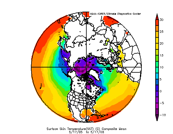
From the map, SSTs in the vicinity of 32N/45W were too cold to support tropical development. Moreover, at this time, sufficient warmth is present only in the extreme south Atlantic, extreme southern GOM, and the Caribbean. If one is familiar with tropical climatology, it is no accident that through mid-June, a sizable majority of the storms that have developed have formed south of 30°N and west of 77°W with the Caribbean and GOM being the favored locations for development.
As the hurricane season approaches, it is useful to pay particular attention to SSTs when something seems to be trying to develop in the northern latitudes. Unless SSTs are warm enough, its development prospects will be slim. With regard to the aforementioned system, the following SSTs were present near the date the storm drew notice:
From the map, SSTs in the vicinity of 32N/45W were too cold to support tropical development. Moreover, at this time, sufficient warmth is present only in the extreme south Atlantic, extreme southern GOM, and the Caribbean. If one is familiar with tropical climatology, it is no accident that through mid-June, a sizable majority of the storms that have developed have formed south of 30°N and west of 77°W with the Caribbean and GOM being the favored locations for development.
0 likes
-
vbhoutex

- Storm2k Executive
- Posts: 29141
- Age: 74
- Joined: Wed Oct 09, 2002 11:31 pm
- Location: Cypress, TX
- Contact:
Matt-hurricanewatcher wrote:I never said that it was going to develop. I was saying don't put your money on just 150 years of records. ...All I said was don't put your farm up for sale on 150 years of records. ....
Uh, Matt do you have access to some records we don't concerning tropical development? It seems to me that there is only about 150 years worth of data of any sort on these types of systems. Maybe I misunderstood your meaning here?
0 likes

-
donsutherland1
- S2K Analyst
- Posts: 2718
- Joined: Mon Sep 15, 2003 8:49 pm
- Location: New York
-
cyclonaut
vbhoutex wrote:Matt-hurricanewatcher wrote:I never said that it was going to develop. I was saying don't put your money on just 150 years of records. ...All I said was don't put your farm up for sale on 150 years of records. ....
Uh, Matt do you have access to some records we don't concerning tropical development? It seems to me that there is only about 150 years worth of data of any sort on these types of systems. Maybe I misunderstood your meaning here?
I agree,though one can argue that 150 years of records really is not much when weather has been happening for much more than that.150 years of records is all we got to work with & going beyond that would be geuss work.
0 likes
Who is online
Users browsing this forum: Cleveland Kent Evans, Hurricanehink and 85 guests