Pacific Northwest Weather

Winter Weather Discussion

Moderator: S2k Moderators

Forum rules

The posts in this forum are NOT official forecast and should not be used as such. They are just the opinion of the poster and may or may not be backed by sound meteorological data. They are NOT endorsed by any professional institution or STORM2K.

Help Support Storm2K
Message
Author
snow_wizzard
Category 4
Category 4
Posts: 994
Joined: Mon Jan 17, 2005 12:15 am
Location: Covington, WA

#5661 Postby snow_wizzard » Mon May 23, 2005 5:58 pm

Even the national guys are saying that cool and wet weather is likely in the Paicific NW for early June. They said the only reason they do not have our temps below normal for the 8 - 14 day period is because the first day or two of the period may be warm.

It is a bit mystifying to me why people are assuming our weather is going to return to normal. Normal is not in the cards this year! Our observed weather may be somewhat normal at times, but the indexes and general patterns will be out of whack. The single most amazing thing to me about this spring is the profoundly negative NAO. It has not been like this since the 60s, with the exception of a couple of brief periods like 1978 and 79. It is very interesting to note that the years with the most negative NAO since 1975 have been year like...

1978...cold winter here

1979...cold winter here

1985...cold winter here

1996...cold winter here

You get the idea! :D
0 likes   

TT-SEA

#5662 Postby TT-SEA » Mon May 23, 2005 6:06 pm

I said that Omaha has received 4.17 inches for the month.

Some places near there have had WAY more.

Omaha gets more precipitation than Seattle from April - September. And certainly has more extreme heat and severe weather.
0 likes   

TT-SEA

#5663 Postby TT-SEA » Mon May 23, 2005 6:10 pm

I am telling you... it will be pretty normal during the first part of June.

Despite the 18Z run of the GFS (which does have a little rain)... and the NCEP discussion.

Remember... normal rainfall for the entire first week of June is only about .35 in Seattle. One little system could put us over that amount and it could still be a pretty bland period.
0 likes   

snow_wizzard
Category 4
Category 4
Posts: 994
Joined: Mon Jan 17, 2005 12:15 am
Location: Covington, WA

#5664 Postby snow_wizzard » Mon May 23, 2005 6:12 pm

For anyone that has any faith in the Covington School net station, I have some bad news for you! Not only is the thermometer high, but they have their wind vane for wind direction set up 180 degrees off! LOL

I have had my suspicions before, and now I can say it has been 180 degrees off from mine enough times to be sure. What a joke!
0 likes   

snow_wizzard
Category 4
Category 4
Posts: 994
Joined: Mon Jan 17, 2005 12:15 am
Location: Covington, WA

#5665 Postby snow_wizzard » Mon May 23, 2005 6:19 pm

Holy Moly! The 18z is showing more than a little rain early June. It is showing a downright cold and wet pattern, with a deep trough. That makes a good three runs in row that are running with the idea of cool and wet. I see no reason to doubt it. Simply a continuation of May, although possibly more below normal temps. Most very wet May's do lead to wet June's.

We could be looking at one of the wettest Apr - June periods ever recorded. Could easily beat any in the 20th century! I am pumped...oh yeah baby!!!!
0 likes   

TT-SEA

#5666 Postby TT-SEA » Mon May 23, 2005 6:23 pm

The 18Z run is too agressive again.

You have to follow trends here and look at the big picture.

Expect normal temperatures and a few showers. NORMAL weather with a fairly weak zonal flow.

You watch.
0 likes   

TT-SEA

#5667 Postby TT-SEA » Mon May 23, 2005 6:27 pm

Some major exceptions to wet May / wet June theory...

1960
1961
1969
1977
2004


Now if we follow 1993... I agree we will end up wet in June.

The first part will be rather quiet though.
0 likes   

snow_wizzard
Category 4
Category 4
Posts: 994
Joined: Mon Jan 17, 2005 12:15 am
Location: Covington, WA

#5668 Postby snow_wizzard » Mon May 23, 2005 7:15 pm

Wow! The GFS and ECMWF are total opposites at end of the week! The GFS shows strong onsore flow and a trough by Friday, while the Euro shows us baking in our own juices. At face value the Euro is showing 90 degrees later in the week. If the GFS is correct Friday will be cool with drizzle. Now that is an amazing difference for that time frame!

If the Euro is right we could have severe heat thunderstorms this weekend. I just don't know which one to believe. The Euro looks awfully extreme though! I hate the pattern it shows for the 8 - 10 day period. It would be warm, muggy, and wet. Very much like earlier this month.
0 likes   

TT-SEA

#5669 Postby TT-SEA » Mon May 23, 2005 7:32 pm

Can you link me to the 8-10 day ECMWF?

What does the MJO indicate? It has been reliable in predicting wet, cool patterns here this year.
0 likes   

TT-SEA

#5670 Postby TT-SEA » Mon May 23, 2005 7:33 pm

I believe reality lies in between the two models.

A weak zonal flow and normal weather.
0 likes   

TT-SEA

#5671 Postby TT-SEA » Mon May 23, 2005 7:49 pm

The Canadian agree with the ECMWF.

The 18Z run of the GFS is out to lunch. But the 12Z run of the ECMWF is too extreme.

When there is a huge difference like this... a compromise is the most likely scenario.
0 likes   

User avatar
cycloneye
Admin
Admin
Posts: 145456
Age: 68
Joined: Thu Oct 10, 2002 10:54 am
Location: San Juan, Puerto Rico

#5672 Postby cycloneye » Mon May 23, 2005 7:49 pm

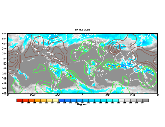
TT-SEA wrote:Can you link me to the 8-10 day ECMWF?

What does the MJO indicate? It has been reliable in predicting wet, cool patterns here this year.


Image

TT I am entering your great discussions here by posting the MJO update.Brown lines indicate the dry phase and the green lines the wet phase.The dry phase is about to enter the NW.Keep it on guys. :)
0 likes   

snow_wizzard
Category 4
Category 4
Posts: 994
Joined: Mon Jan 17, 2005 12:15 am
Location: Covington, WA

#5673 Postby snow_wizzard » Mon May 23, 2005 7:55 pm

TT...here is the ECMWF link. It is a composite of days 8 - 10.

http://meteocentre.com/models/ecmwf_ame ... 9panel.gif

It shows weak SE flow...yuck!

You are correct...if it is an average of the two it will be boring.

The MJO has greatly sped up and is not as good of gauge as it has been. It was taking a month or more for a full cycle now it's just 2 or 3 weeks. I highly doubt the weather patterns can fully react to that.
0 likes   

TT-SEA

#5674 Postby TT-SEA » Mon May 23, 2005 7:55 pm

What are the typical length of the cycles?

I believe that means drier than normal through the first week of June. I do not understand why the NCEP discussion is not more scientific. This seems so obvious.
0 likes   

TT-SEA

#5675 Postby TT-SEA » Mon May 23, 2005 7:58 pm

O.K... maybe its not so obvious!!
0 likes   

AnthonyC
Category 2
Category 2
Posts: 734
Joined: Fri Jan 07, 2005 4:38 pm

#5676 Postby AnthonyC » Mon May 23, 2005 7:59 pm

With a thermal trough off the coast, it will heat up in Western Washington. But where will this trough make landfall? Will it migrate up the coast and move inland over Eastern Washington, or will it move ashore near southern Oregon? This makes all the difference with temperatures...in any event, temperatures could range from 70-90F this upcoming week. If you were to compromise between the GFS and EMCWF, you'd get 80F. That seems accurate in this situation...it's a little too early in the season for an extensive thermal trough.

Anthony
0 likes   

User avatar
W13
Category 5
Category 5
Posts: 1938
Joined: Sun Jul 18, 2004 2:46 pm
Location: Kent, Washington

#5677 Postby W13 » Mon May 23, 2005 10:51 pm

Here is a map of the high temperatures from yesterday:

Image

You can see how the Northwest and the Northeast are sitting ducks for this invading heat - and it looks as if we will be right in the thick of things in a couple of days. :)
0 likes   

TT-SEA

#5678 Postby TT-SEA » Mon May 23, 2005 11:30 pm

If the 00Z run of the GFS is correct... there will be some very active weather this weekend.

Thunder and lightning will be a given.

And we could get significant rain if you end up under a thunderstorm.
0 likes   

TT-SEA

#5679 Postby TT-SEA » Mon May 23, 2005 11:59 pm

The 00Z run of the GFS is TOTALLY different than the 18Z run as I expected.

The weekend system looks fun... warm and thundery.

Then we transition into a bland, weak zonal flow for the first week of June.

A nice compromise between the 18Z run and the ECMWF.
0 likes   

snow_wizzard
Category 4
Category 4
Posts: 994
Joined: Mon Jan 17, 2005 12:15 am
Location: Covington, WA

#5680 Postby snow_wizzard » Tue May 24, 2005 12:24 am

You have got to be kidding! Look at how that little upper level low manages to move right in on top of us this weekend!

http://www.srh.noaa.gov/cwwd/models/00z ... 0_120m.htm

I swear, this month has been a case of...if it can find any way to rain, it will!

Needless to say, if this run verifies it will indeed be an exciting weekend and we will most likely be looking at our second wettest May on record (Sea - Tac records). As it stands now we are at 3.22 and the years to beat are:

1948 - 4.76

1977 - 3.70

1984 - 3.38

2000 - 3.27

Prior to 1945 the only years to have more than 3.22 were

1879

1893

1896

1900

1905

1936

1941

This has been a wet one!
0 likes   


Return to “Winter Weather”

Who is online

Users browsing this forum: No registered users and 2 guests