"The Big One for the Big Easy" by Mike Naso

This is the general tropical discussion area. Anyone can take their shot at predicting a storms path.

Moderator: S2k Moderators

Forum rules

The posts in this forum are NOT official forecasts and should not be used as such. They are just the opinion of the poster and may or may not be backed by sound meteorological data. They are NOT endorsed by any professional institution or STORM2K. For official information, please refer to products from the National Hurricane Center and National Weather Service.

Help Support Storm2K
Message
Author
Anonymous

"The Big One for the Big Easy" by Mike Naso

#1 Postby Anonymous » Sat May 28, 2005 12:12 am

September 1, a Tropical Depression forms just to the Northeast of the Yucatan. It is moving northeast at 4 mph, and is over very warm waters of about 86 degrees, and shear is 5 kts or less. Six hours later, organization continues, and the system is upgraded to Tropical Storm Erin.

As the late night of the 1st turns into the early morning of the 2nd, Erin has strengthened up to 50 mph, and 997 mb. Erin shows some signs of speeding up, now moving north-northeast at 8 mph. However, a forecast turn back to the west should occur, which should put Erin just south of Intercoastal City, LA in 120 hrs as a Category 2 hurricane of 100 mph. However, by the early afternoon of the 2nd, Erin is already up to 65 mph, and 990 mb. Now moving north at 10 mph, the forecast track has shifted to Erin being along the coast of Lousiana from 48-96 hrs, and being a Category 3 of 115 mph, and weakening to 90 mph by the time Erin moves back away from the coast towards Texas in 120 hrs.

However, by 11pm that evening, Erin becomes a Category 1 Hurricane, with winds of 80 mph and a pressure of 982 mb, and still moving due north at 11 mph. By early the morning on September 3, Hurricane Erin has strengthened up to 100 mph, a Category 2 storm with it's central pressure down to 965 mb. Since Erin is moving just barely west of north at 12 mph, the forecast track now has Erin making landfall near Port Sulphur in extreme Southeast Louisiana in 36 hours, as a Category 3 storm of 125 mph.

Now knowing how big a risk Erin is to downtown New Orleans, a mandatory evacuation order is issued by the mayor. As many struggle to evacuate during the day, many are astonished by Erin's intensification. By 5pm, Hurricane Erin has achieved Category 3 status, with winds of 120 mph and a pressure of 948 mb, and is moving towards the north-northwest at 11 mph. Three hours later, Erin has achieved Category 4 intensity, with winds of up to 135 mph and a pressure of 938 mb. By 11pm, the reconnaissance aircraft is reporting a stadium effect, and severe turbulence and lightning in the eyewall. They also report a central pressure of 926 mb, and flight level winds of 150 kts.

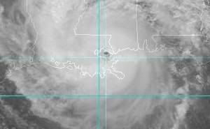
As the late night of September 3 becomes early morning September 4, Hurricane Erin has winds of 155 mph, and a 925 mb pressure, moving northwest at 9 mph. As people wake up in the early morning of September 4, all TV and Cable News Networks give out the latest. Hurricane Erin, a Category 5 Hurricane with winds of up to 165 mph and a pressure of 921 mb, is about 120 miles East-Southeast of New Orleans, LA, moving west-northwest at 7 mph. Hurricane Erin's eye on radar shows a deep red eyewall 15 miles wide, tightening. Landfall is expected sometime in the early-mid afternoon.

Forecasters are once again amazed when reconnaissance aircraft reports a central pressure of 915 mb, and sustained winds of 175 mph around 12pm Eastern, 11am central. Hurricane Erin, now moving just north of west at 9 mph, is moving over the southern area of Lake Borgne. Just as reconnaissance is leaving the eyewall, they find a 913 mb pressure, and flight level winds of 178 kts in the Western Eyewall. At 2pm Eastern, 1pm Central, Hurricane Erin makes landfall in New Orleans, LA as a Category 5 hurricane with winds of 180 mph, and a pressure of 913 mb.
Image
Image

A storm surge of over 20 feet pushes water into Chalmette, and even into downtown New Orleans. However, winds push the water from Lake Pontchartrain south, into the towns of West End, Seabrook and even into Downtown. Areas of Laplace, Reserve, Matairie, Kenner, Frenier, and all surrounding areas are flooded, including the streams and rivers and bayous.

Winds are recorded in downtown to 140 mph, before the instrument failed. An unofficial gust to 185 mph was recorded in New Orleans by a storm chaser. The chaser also recorded an unofficial pressure of 917 mb. The chaser was in the eastern eyewall at the time, and did not experience the worst, which was in the western eyewall. Although all instruments were destroyed, winds are estimated to have been sustained at 180 mph for a short period of time over the New Orleans and Matairie area. Winds probably gusted as high as 210 mph in these areas as well. Winds were sustained at up to 135 mph in Laplace and a gust to 156 mph was recorded.

As Erin weakens to a Tropical Depression 36 hours later, waters begin to recede. Those who evacuated were thankful, those who did not were either lucky, or parished. Hurricane Erin goes down in history, as the costliest hurricane in US History. The damage is inconceivable in some areas, with no debris, just flat land where homes used to be. The water has left snakes and bugs and animals loose, into towns. Some people die from being ill from dirty water, others are bit by wild animals, and suffer. The biggest relief effort in US History is put in place. The national guard cracks down on looters, while many go to nearby shelters.

Louisianians will never forget Erin, and the scar it forever left on New Orleans. Places like Covington, Laplace, Matairie, and Reserve are stuck in people's minds as the cities that will take years to recover. Erin was the Big One, for the Big Easy.

A Hurricane like this will happen one day. It may be a Cindy, or a Dolly, an Ike or an Erin...and you must be prepared. Every storm, every season, everytime.

Made by Mike Naso.

Leave a comment on what you thought of the story if you like.
0 likes   

Anonymous

#2 Postby Anonymous » Sat May 28, 2005 12:49 am

Absoultely LOVE the track---now can you just move it 10degrees to the east please? :D Would be a good test for our building codes lol
Last edited by Anonymous on Sat May 28, 2005 1:06 am, edited 3 times in total.
0 likes   

User avatar
MSRobi911
S2K Supporter
S2K Supporter
Posts: 1259
Age: 70
Joined: Sun Sep 14, 2003 1:55 pm
Location: Pascagoula, Misssissippi

#3 Postby MSRobi911 » Sat May 28, 2005 12:51 am

Why Jek? that is right on me!

Mary
0 likes   

Anonymous

#4 Postby Anonymous » Sat May 28, 2005 12:54 am

MSRobi911 wrote:Why Jek? that is right on me!

Mary


5 degrees west would be you, 10 would be off the E Coast of Fla! Thats me 8-)


--edit--actually, that very track, you are Hit MsRobi 5 degrees further east, u are dealling with a weak storm because it would be going up the E Coast of Fla and land interractions would keep the storm in check.
Last edited by Anonymous on Sat May 28, 2005 1:07 am, edited 1 time in total.
0 likes   

User avatar
yoda
Category 5
Category 5
Posts: 7874
Joined: Tue Jan 13, 2004 3:51 pm
Location: Springfield VA (20 mins south of DC)
Contact:

#5 Postby yoda » Sat May 28, 2005 12:58 am

:eek: :eek: :eek:
0 likes   

User avatar
Radar
Category 1
Category 1
Posts: 425
Joined: Fri Aug 27, 2004 11:04 pm
Location: Biloxi,MS

#6 Postby Radar » Sat May 28, 2005 1:30 am

Very surreal post and one I hope never becomes a reality. I hate for any place to feel the effects of a Cat 5 hurricane but I know that in the United States the worst case scenario for one is New Orleans. Not only would the property damage be massive but the loss of life would be profound. Eventually your post will become a reality, last year New Orleans once again escaped it, this year will N.O. be as lucky? Good job on the post!
0 likes   

Matt-hurricanewatcher

#7 Postby Matt-hurricanewatcher » Sat May 28, 2005 2:15 am

I don't know what to say, But someting like this will happen maybe this year or 50 years from now. In living in a city under sea level is just plain *unsmart*. In for that Matter any citie with in 5 miles of the sea south of 30 north. It is now time to listen to the facts in get away from these death traps we call seashore cities. If we did we would never have to worrie about this. Just my 2 cents worth.
0 likes   

Derek Ortt

#8 Postby Derek Ortt » Sat May 28, 2005 3:26 am

worse case scenario, Miami is leveled first and 100,000 <b>ACTIVE DUTY</b> troops are already deployed there (28,000 were deployed after Andrew and the Pentagon had to be activated to prevent all out war from occurring). Then the cat 5 levels NO and we have 10s of thousands dead. Response is slow as the military is busy keeping order in MIA, resulting in 10s of thousands more dying in the immediate aftermath
0 likes   

Anonymous

#9 Postby Anonymous » Sat May 28, 2005 3:37 am

I thought this was a pretty realistic scenario.
0 likes   

Derek Ortt

#10 Postby Derek Ortt » Sat May 28, 2005 4:04 am

yours is realistic, but not worse case
0 likes   

Anonymous

#11 Postby Anonymous » Sat May 28, 2005 4:28 am

It is one worst case. Another would be Miami first.
0 likes   

Valkhorn
Category 1
Category 1
Posts: 492
Joined: Wed Sep 10, 2003 4:09 am
Contact:

#12 Postby Valkhorn » Sat May 28, 2005 4:49 am

Actually, that's not realistic at all.

If NO gets flooded it will take MONTHS for the waters to ever recede. Once the water goes over the pumps that normally keep the waters out during flooding rains the pumps will stop working. Once the water is in the levee system and the water is up to sea level there will be no real way to get the water out with the existing pumps.

If New Orleans is literally submerged it will remain that way for months.

Twenty feet of storm surge would do that. In fact, Hurricane Georges had enough surge to accomplish that, too.

There is no way the water could 'recede' at 20 feet in days.

Plus the death toll will be substantially higher. If there isn't enough time for those who live in and around New Orleans to evacuate they would be caught on I10 and I12 trying to leave the city. Traffic will be backed up for miles if there is less than a day and a half to evacuate.

Also, if it comes in on that angle any traffic on I10 across Ponchartrain, plus any traffic on the Causeway will be lost. The bridges aren't that high off the ground, in fact 20 feet of surge would submerge all of both bridges except for the ship passes that occasionally rise 100 to 120ft above the lake.

Plus the wave action would level those two arteries into New Orleans.

I live one hour north of New Orleans. I don't think Mike has even gotten close to what this might do.
0 likes   

Valkhorn
Category 1
Category 1
Posts: 492
Joined: Wed Sep 10, 2003 4:09 am
Contact:

#13 Postby Valkhorn » Sat May 28, 2005 4:57 am

I also forgot to add, there would be the possibility that I59 into New Orleans on the western side of Ponchartrain would be gone too. It's a viaduct not much higher than the I10 bridges with only one 'ship pass' over mostly swampland and a few boat channels.

Water pushed from the side into Ponchartrain from the gulf would reach the I59 Viaduct as well, and with the wave/wind action it could be demolished too in sections.

The only other arteries into New Orleans are I10 from the west (Lafayette, Baton Rouge) and I310 from the south. If the water is at 20 feet of surge it could take out I 310 as well since not all of that is elevated, and everything below the city is at sea level pretty much since it's mostly swamp land.

That leaves I10 from the West, and if water is pushed in towards I59 it could leak into the Viaducts on I10 near the I310 junction.

New Orleans sits in a swamp. It's below sea level.

I honestly don't think this 'worst' case scenario is even remotely close to how bad the city would be after something like this happened.
0 likes   

Derek Ortt

#14 Postby Derek Ortt » Sat May 28, 2005 4:59 am

and then adding on top of the mess you described, what I described with the pentagon and army busy keeping everyone in MIA from killing themselves if it was MIA first.
0 likes   

Valkhorn
Category 1
Category 1
Posts: 492
Joined: Wed Sep 10, 2003 4:09 am
Contact:

#15 Postby Valkhorn » Sat May 28, 2005 5:07 am

Image

This is I10 West of NO heading East. Just about all Interstate arteries into and out of the city are elevated above water.

We remember what Ivan did to I10 near Pensacola right?
0 likes   

User avatar
AussieMark
Category 5
Category 5
Posts: 5858
Joined: Tue Sep 02, 2003 6:36 pm
Location: near Sydney, Australia

#16 Postby AussieMark » Sat May 28, 2005 5:49 am

Since we are talking about worse case scenarios here.

The worst case scenario could be Mikes and Dereks scenario combined.

a Category 4 or 5 plowing right thru Miami head on and then gaining back intensity in the Gulf and then striking New Orleans.

Can u think of any greater natural disaster
0 likes   

User avatar
TampaFl
S2K Supporter
S2K Supporter
Posts: 1905
Age: 68
Joined: Thu Sep 04, 2003 11:23 am
Location: Tampa, FL

#17 Postby TampaFl » Sat May 28, 2005 6:09 am

:eek: :eek: :eek:
0 likes   

User avatar
sunny
Category 5
Category 5
Posts: 7031
Joined: Fri Aug 06, 2004 2:11 pm
Location: New Orleans

#18 Postby sunny » Sat May 28, 2005 6:44 am

Derek makes a valid, yet scary, point regarding military deployment in the event of a hurricane. lol - our governor has assured us that the Louisiana National Guard is ready should we be affected by a major hurricane here in Louisiana. I have trouble believing that given that 3,000 of our troops are in Iraq, and not due back in the states until October.

This is a frightening scenario for me. Unless this would be a slow moving storm, don't see how our new "72 hour advance evacuation procedures" would work.
0 likes   

User avatar
BayouVenteux
S2K Supporter
S2K Supporter
Posts: 775
Age: 64
Joined: Thu Sep 04, 2003 3:26 pm
Location: Ascension Parish, Louisiana (30.3 N 91.0 W)

Re: "The Big One for the Big Easy" by Mike Naso

#19 Postby BayouVenteux » Sat May 28, 2005 7:32 am

~Floydbuster wrote:...Places like Covington, Laplace, Matairie, and Reserve are stuck in people's minds as the cities that will take years to recover. Erin was the Big One, for the Big Easy...

A storm of that magnitude, on that particular track, might not only push water into the communities adjacent to the southwestern 1/4 of Lake Pontchartrain you mention, but other areas normally not subjected to the magnitude of surge flooding more commonly experienced in areas to the south and east of the lake. The local geography is such that you essentially have a marsh/swampland basin extending roughly 20-25 miles west from the lake, comprising Lake Maurepas and the adjacent tributaries feeding into it, the Tickfaw, Amite, and Blind Rivers. Portions of St. John, St. James, Ascension, and Livingston Parishes would take on A LOT of water off of the excess of the Lake Pontchartrain surge, and this in turn would only be exacerbated if the system was a copious rainmaker, because, let's face it, the run-off wouldn't have anywhere to go.

Thankfully your scenario is an extreme instance, but it serves to remind us how vulnerable we are––even to lesser systems––due to the unique geography of the region.
0 likes   

User avatar
sunny
Category 5
Category 5
Posts: 7031
Joined: Fri Aug 06, 2004 2:11 pm
Location: New Orleans

#20 Postby sunny » Sat May 28, 2005 7:38 am

Very true BayouVenteux. I still remember LaPlace after Juan. Looked like a lake from the I10 bridge a week after the fact, and he went in over Lafayette if memory serves. I'd hate to see what would happen if a system took this track. It would be devastating for the entire southern Louisiana region.
0 likes   


Return to “Talkin' Tropics”

Who is online

Users browsing this forum: Hypercane_Kyle and 227 guests