11 PM EDT Advisory=TS Warning for W.Cuba,35 mph,17.6-83.9w
Moderator: S2k Moderators
Forum rules
The posts in this forum are NOT official forecasts and should not be used as such. They are just the opinion of the poster and may or may not be backed by sound meteorological data. They are NOT endorsed by any professional institution or STORM2K. For official information, please refer to products from the National Hurricane Center and National Weather Service.
- cycloneye
- Admin

- Posts: 148859
- Age: 69
- Joined: Thu Oct 10, 2002 10:54 am
- Location: San Juan, Puerto Rico
11 PM EDT Advisory=TS Warning for W.Cuba,35 mph,17.6-83.9w
WTNT31 KNHC 090228
TCPAT1
BULLETIN
TROPICAL DEPRESSION ONE ADVISORY NUMBER 2
NWS TPC/NATIONAL HURRICANE CENTER MIAMI FL
11 PM EDT WED JUN 08 2005
...DEPRESSION CONTINUES MOVING SLOWLY NORTHWARD OVER THE NORTHWEST
CARIBBEAN...
AT 11 PM EDT...0300Z...THE GOVERNMENT OF CUBA HAS ISSUED A TROPICAL
STORM WARNING FOR WESTERN CUBA FOR THE PROVINCES OF PINAR DEL RIO
AND THE ISLE OF YOUTH.
INTERESTS IN THE NORTHWESTERN CARIBBEAN SHOULD CLOSELY MONITOR THE
PROGRESS OF THIS SYSTEM.
FOR STORM INFORMATION SPECIFIC TO YOUR AREA...INCLUDING POSSIBLE
INLAND WATCHES AND WARNINGS...PLEASE MONITOR PRODUCTS ISSUED
BY YOUR LOCAL WEATHER OFFICE.
AT 11 PM EDT...0300Z...THE POORLY-DEFINED CENTER OF TROPICAL
DEPRESSION ONE WAS LOCATED NEAR LATITUDE 17.6 NORTH... LONGITUDE
83.9 WEST OR ABOUT 210 MILES... 340 KM... WEST-SOUTHWEST OF GRAND
CAYMAN AND ABOUT 290 MILES... 470 KM...SOUTH-SOUTHEAST OF THE
WESTERN TIP OF CUBA.
THE DEPRESSION IS MOVING TOWARD THE NORTH NEAR 6 MPH
... 9 KM/HR...AND THIS GENERAL MOTION IS EXPECTED TO CONTINUE WITH
SOME INCREASE IN FORWARD SPEED DURING THE NEXT 24 HOURS.
MAXIMUM SUSTAINED WINDS ARE NEAR 35 MPH... 55 KM/HR...WITH HIGHER
GUSTS...MAINLY IN RAIN BANDS TO THE NORTHEAST OF THE CENTER. SOME
STRENGTHENING IS FORECAST DURING THE NEXT 24 HOURS...AND THE
DEPRESSION COULD BECOME A TROPICAL STORM ON THURSDAY.
THE MINIMUM CENTRAL PRESSURE REPORTED BY AN AIR FORCE RESERVE UNIT
HURRICANE HUNTER AIRCRAFT WAS 1003 MB...29.62 INCHES.
HEAVY RAINFALL...ACCOMPANIED BY SQUALLS...SHOULD BEGIN TO SPREAD
ACROSS THE CAYMAN ISLANDS AND WESTERN CUBA TONIGHT AND THURSDAY.
MOISTURE FLOWING FROM THE SOUTHWEST INTO THE DEPRESSION IS PRODUCING
VERY HEAVY RAINS OVER PORTIONS OF CENTRAL AMERICA...PARTICULARLY
NICARAGUA AND HONDURAS. THESE RAINS COULD CAUSE LIFE-THREATENING
FLASH FLOODS AND MUD SLIDES.
REPEATING THE 11 PM EDT POSITION...17.6 N... 83.9 W. MOVEMENT
TOWARD...NORTH NEAR 6 MPH. MAXIMUM SUSTAINED WINDS... 35 MPH.
MINIMUM CENTRAL PRESSURE...1003 MB.
AN INTERMEDIATE ADVISORY WILL BE ISSUED BY THE NATIONAL HURRICANE
CENTER AT 2 AM EDT FOLLOWED BY THE NEXT COMPLETE ADVISORY AT 5 AM
EDT.
FORECASTER PASCH
0 likes
Visit the Caribbean-Central America Weather Thread where you can find at first post web cams,radars
and observations from Caribbean basin members Click Here
and observations from Caribbean basin members Click Here
- cycloneye
- Admin

- Posts: 148859
- Age: 69
- Joined: Thu Oct 10, 2002 10:54 am
- Location: San Juan, Puerto Rico
TCDAT1
TROPICAL DEPRESSION ONE DISCUSSION NUMBER 2
NWS TPC/NATIONAL HURRICANE CENTER MIAMI FL
11 PM EDT WED JUN 08 2005
DATA FROM THE AIR FORCE HURRICANE HUNTERS INDICATE THAT THE
DEPRESSION REMAINS POORLY-ORGANIZED...WITH A BROAD AREA OF LIGHT
WINDS NEAR THE ESTIMATED CENTER. THEY DID REPORT ONE 35 KT WIND AT
THE 1000 FT FLIGHT LEVEL...ON THEIR LAST OUTBOUND LEG ABOUT 70 N MI
NE OF THE CENTER. BASED ON THAT OBSERVATION...THE INTENSITY IS
INCREASED TO 30 KT FOR THIS ADVISORY. ON SATELLITE IMAGERY
HOWEVER...THE CLOUD PATTERN IS NOT IMPRESSIVE AND THE BANDING
FEATURES WARRANT ONLY A T1.0 ON THE DVORAK SCALE. SOUTHWESTERLY
SHEAR...ASSOCIATED WITH A SHARP UPPER-LEVEL TROUGH ALONG 90W...
CONTINUES TO AFFECT THE TROPICAL CYCLONE. SOME ABATEMENT OF THE
SHEAR IS EXPECTED BUT GLOBAL MODEL GUIDANCE SUGGESTS THAT THE
UPPER-LEVEL WINDS WILL BE ONLY MARGINALLY FAVORABLE FOR
STRENGTHENING DURING THE NEXT FEW DAYS. THE OFFICIAL INTENSITY
FORECAST IS THE SAME AS THE PREVIOUS ONE. THIS IS A LITTLE HIGHER
THAN THE SHIPS GUIDANCE...AND A LITTLE LOWER THAN THE GFDL
FORECAST.
INITIAL MOTION IS SLOWLY NORTHWARD...005/05. GLOBAL MODELS SHOW A
RIDGE BUILDING TOWARD THE SOUTHEAST U.S. COAST OVER THE NEXT COUPLE
OF DAYS...WHICH SHOULD INDUCE A GRADUAL BEND IN HEADING TOWARD THE
NORTH-NORTHWEST...AND SOME INCREASE IN FORWARD SPEED. THE
OFFICIAL FORECAST FOR THIS PACKAGE IS QUITE SIMILAR TO THE PREVIOUS
ONE. THIS IS SLIGHTLY EAST OF THE LATEST GFDL TRACK AND SIMILAR TO
THE DEEP-LAYER BAM TRACK.
IT IS IMPORTANT NOT TO FOCUS ON THE EXACT TRACK SHOWN HERE...BECAUSE
OF UNCERTAINTIES IN THE FORECAST...ESPECIALLY IN THE 2-3 DAY TIME
FRAME.
FORECASTER PASCH
FORECAST POSITIONS AND MAX WINDS
INITIAL 09/0300Z 17.6N 83.9W 30 KT
12HR VT 09/1200Z 18.7N 84.1W 30 KT
24HR VT 10/0000Z 21.0N 84.6W 35 KT
36HR VT 10/1200Z 23.5N 85.7W 45 KT
48HR VT 11/0000Z 25.8N 86.8W 50 KT
72HR VT 12/0000Z 30.5N 88.5W 50 KT...INLAND
96HR VT 13/0000Z 35.0N 88.0W 25 KT...INLAND
120HR VT 14/0000Z...INLAND...DISSIPATED
0 likes
Visit the Caribbean-Central America Weather Thread where you can find at first post web cams,radars
and observations from Caribbean basin members Click Here
and observations from Caribbean basin members Click Here
Hmmm.....I dont think this should be considered a TS....Derek hit on it earlier about the VORTEX reports of cool temperatures in the center, and now at this time its taking on a comma shape. I think this might be subtropical.
Also, is it just me or is a center forming west of cayman? Might be my bad eyes.
Here, check and see...
http://www.ssd.noaa.gov/PS/TROP/DATA/RT ... -loop.html
Also, is it just me or is a center forming west of cayman? Might be my bad eyes.
Here, check and see...
http://www.ssd.noaa.gov/PS/TROP/DATA/RT ... -loop.html
Last edited by Normandy on Wed Jun 08, 2005 9:53 pm, edited 1 time in total.
0 likes
Possibly, but its still looking rather poor right now. I think Recon won't be able to find that center they were tracking earlier...I can't spot it (Well at least a defined low level circulation, i see a broader one but its weak of the coast of honduras)....I think they should look at the spot near Cayman.
0 likes
- gatorcane
- S2K Supporter

- Posts: 23706
- Age: 48
- Joined: Sun Mar 13, 2005 3:54 pm
- Location: Boca Raton, FL
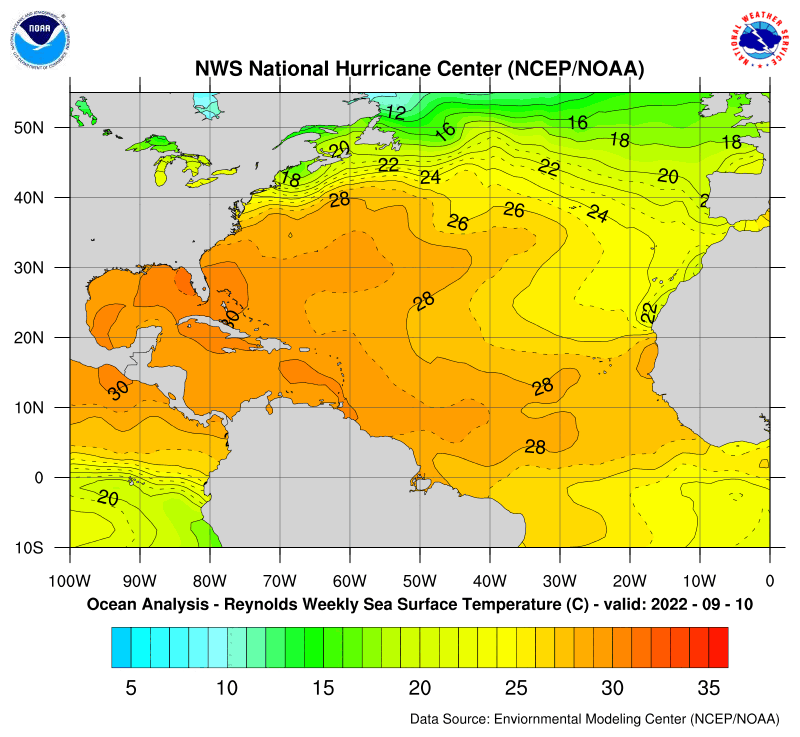
SSTs are warm where it's at now but the GOM is not all that warm yet...it's enough to support tropical storm development but it is nowhere near boiling out there like we see later in the summer. Looks like the SST anomalies show the GOM is cooler than expected for this time of year...
NHC products:
SST Analysis:

SST Anomaly:

NHC products:
SST Analysis:

SST Anomaly:

0 likes
-
StormChasr
- gatorcane
- S2K Supporter

- Posts: 23706
- Age: 48
- Joined: Sun Mar 13, 2005 3:54 pm
- Location: Boca Raton, FL
Don't see any serious development--lots of dry air in the Gulf to suck in. Still some shear, and SSTs not prime yet. I bet it doesn't hold together long enough to be a TS on landfall. Just a big rainmaker for wherever it ends up. Right now, it kinda looks like the Ivan track.
Yes it does but Ivan had 165 mph winds where TD1 is currently located
0 likes
Also it builds the ridge in more strongly than I would have thought. But the original ideas that the weaker the system was, the more it was going to shunt were good. Now I don't think the model has it right (and I certainly could be wrong) because I would expect a closed low at landfall and a landfall on the eastern side of the range I predicted this morning.
Here's the link in case you don't have a direct one to NCEP C.O.:
http://www.nco.ncep.noaa.gov/pmb/nwprod/analysis/
Lately they've been one of the fastest in getting the data they have (even thoguh I don't use Nested Grid or RUC {except for severe weather}).
Steve
Here's the link in case you don't have a direct one to NCEP C.O.:
http://www.nco.ncep.noaa.gov/pmb/nwprod/analysis/
Lately they've been one of the fastest in getting the data they have (even thoguh I don't use Nested Grid or RUC {except for severe weather}).
Steve
0 likes
Who is online
Users browsing this forum: Ulf and 54 guests


