Personal Discussion Number 3 of Arlene (01L)

This is the general tropical discussion area. Anyone can take their shot at predicting a storms path.

Moderator: S2k Moderators

Forum rules

The posts in this forum are NOT official forecasts and should not be used as such. They are just the opinion of the poster and may or may not be backed by sound meteorological data. They are NOT endorsed by any professional institution or STORM2K. For official information, please refer to products from the National Hurricane Center and National Weather Service.

Help Support Storm2K
Message
Author
DoctorHurricane2003

Personal Discussion Number 3 of Arlene (01L)

#1 Postby DoctorHurricane2003 » Fri Jun 10, 2005 9:23 pm

S2K Disclaimer: The following post is NOT an official forecast and should not be used as such. It is just the opinion of the poster and may or may not be backed by sound meteorological data. It is NOT endorsed by any professional institution including storm2k.org For Official Information please refer to the NHC and NWS products.

Personal Disclaimer: All official products are located at http://www.nhc.noaa.gov/ . For warning and evacuation information, please turn to your local NWS office website via a link at http://www.srh.noaa.gov/ or tune in to your local television station.

Graphic Disclaimer: The Graphic provided in this forecast is not official in any way and not endorsed by S2K, NWS, or NOAA.


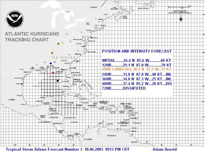
Arlene has steadily intensified throughout the day, dropping to 990 mb in the latest reconnaissance aircraft reports. She has also become much better organized with storms around the center and winds near 70 MPH. Arlene has also accelerated in forward speed and will reach the coastline sometime tomorrow afternoon, after taking directional jogs west of north. Based on this information, my forecast has been bumped up significantly. I am now expecting Arlene to be 75 KT at landfall, near Gulf Shores, AL, and I make that forecast with slight skepticism that it could also be 70 KT. Afterwards, Arlene should steadily weaken as she moves north into Alabama and the Applachians. For right now, I do not expect any rapid intensification that will take it beyond 75 KT. To have that occur, Arlene would need to quickly organize her storms completely around the center with significant outflow, and that looks unlikely.

From Arlene, expect heavy rainfall with locally up to 8" possible in some locations, especially north and east of the center. High winds could carry excess Ivan debris, especially along the beach, so be mindful of this, and expect a storm surge of at least 5 feet near and just to the east of the center. Keep in tune to your local television news station for the latest evacuation and advisory information for your area.

The following is my personal forecast graphic of Arlene:
Image
0 likes   

Brent
S2K Supporter
S2K Supporter
Posts: 38266
Age: 37
Joined: Sun May 16, 2004 10:30 pm
Location: Tulsa Oklahoma
Contact:

#2 Postby Brent » Fri Jun 10, 2005 9:25 pm

Looks good. :)
0 likes   
#neversummer

User avatar
Radar
Category 1
Category 1
Posts: 425
Joined: Fri Aug 27, 2004 11:04 pm
Location: Biloxi,MS

#3 Postby Radar » Fri Jun 10, 2005 9:32 pm

Nice Post!! I must say that for the first storm of the season Arlene has been quite the challenge to track... She has given us all a few surprises and I feel she may have a few more surprises in store for us before she finally moves inland and dumps some more torrential rains.. Keep up the good work!
0 likes   

JTD
Category 5
Category 5
Posts: 1558
Joined: Sun Nov 02, 2003 6:35 pm

#4 Postby JTD » Fri Jun 10, 2005 9:37 pm

Brent wrote:Looks good. :)
0 likes   


Return to “Talkin' Tropics”

Who is online

Users browsing this forum: No registered users and 610 guests