Tropical Depression Beatriz,It has dissipated
Moderator: S2k Moderators
Forum rules

The posts in this forum are NOT official forecasts and should not be used as such. They are just the opinion of the poster and may or may not be backed by sound meteorological data. They are NOT endorsed by any professional institution or STORM2K. For official information, please refer to products from the National Hurricane Center and National Weather Service.
-
cycloneye

- Admin

- Posts: 148856
- Age: 69
- Joined: Thu Oct 10, 2002 10:54 am
- Location: San Juan, Puerto Rico
TCDEP2
TROPICAL STORM BEATRIZ DISCUSSION NUMBER 7
NWS TPC/NATIONAL HURRICANE CENTER MIAMI FL
2 AM PDT THU JUN 23 2005
ALTHOUGH DVORAK T-NUMBERS WERE UP TO 3.5...CORRESPONDING TO AN
INTENSITY OF 55 KT...AT 06Z...THE COVERAGE OF DEEP CONVECTION
SUBSEQUENTLY DIMINISHED. MOREOVER...THE OVERALL CLOUD PATTERN IS
RAGGED-LOOKING WITH NO DISCERNABLE BANDING. CONTINUITY FROM
PREVIOUS VISIBLE FIXES SUGGESTS THAT THE CENTER IS NEAR THE EASTERN
EDGE OF THE DENSE OVERCAST. ASSUMING THIS...AND USING THE SHEAR
PATTERN WITH THE DVORAK TECHNIQUE...ONE OBTAINS A T-NUMBER CLOSER
TO 3.0. CURRENT INTENSITY IS HELD AT 45 KT FOR THIS ADVISORY.
SOME STRENGTHENING IS STILL POSSIBLE...AND IS ACKNOWLEDGED IN THE
FORECAST. HOWEVER...THE WINDOW OF OPPORTUNITY FOR FURTHER
INTENSIFICATION WILL BE CLOSING SOON AS THE STORM HEADS FOR
COOLER WATERS. THE OFFICIAL WIND SPEED FORECAST IS A LITTLE HIGHER
THAN THAT SHOWN BY THE LATEST SHIPS GUIDANCE.
INITIAL MOTION ESTIMATE IS 290/12...BASED LARGELY ON CONTINUITY.
STEERING CURRENTS ARE FORECAST TO WEAKEN OVER THE NEXT FEW DAYS AS
A MID-TROPOSPHERIC TROUGH APPROACHING SOUTHERN CALIFORNIA AND THE
BAJA PENINSULA BREAKS DOWN THE MID-LEVEL RIDGE TO THE NORTH OF THE
TROPICAL CYCLONE. THEREFORE THE TRACK FORECAST SHOWS A SLOWING OF
THE FORWARD SPEED TO A DRIFT BY THE LATTER PART OF THE FORECAST
PERIOD. IT IS POSSIBLE THAT THE SYSTEM COULD TURN SOUTHWARD OR
SOUTHEASTWARD IN 4-5 DAYS IN RESPONSE TO THE DEVELOPMENT OF A
CYCLONIC CIRCULATION TO ITS EAST. BY THAT TIME...HOWEVER...BEATRIZ
IS EXPECTED TO BE REDUCED TO A WEAK REMNANT LOW THAT WILL BE
STEERED MAINLY BY THE LOW-LEVEL TRADE WIND FLOW.
FORECASTER PASCH
FORECAST POSITIONS AND MAX WINDS
INITIAL 23/0900Z 16.3N 109.3W 45 KT
12HR VT 23/1800Z 16.8N 111.0W 55 KT
24HR VT 24/0600Z 17.4N 113.0W 55 KT
36HR VT 24/1800Z 17.8N 114.5W 45 KT
48HR VT 25/0600Z 17.9N 115.3W 40 KT
72HR VT 26/0600Z 18.0N 116.0W 30 KT...DISSIPATING
96HR VT 27/0600Z 18.0N 117.0W 20 KT...REMNANT LOW
120HR VT 28/0600Z 18.0N 118.0W 20 KT...REMNANT LOW
I am surprised that nobody posted the 2 AM PDT.Well here it is.
0 likes
Visit the Caribbean-Central America Weather Thread where you can find at first post web cams,radars
and observations from Caribbean basin members Click Here
and observations from Caribbean basin members Click Here
-
Mezocyclone

- Tropical Storm

- Posts: 118
- Joined: Mon Jul 21, 2003 9:16 am
- Location: Largo, Florida... Pinellas County
- Contact:
New Age, New Ideas, Open Minds
Derek Ortt wrote:of course Matt would know more than everyone els, as he has so demonstrated here all season so far.
In all seriousness Matt, please be respectful of those who have went through the years of training (including those at NHC whom you so love to trash)
Perhaps the years of training did not include having an open mind to another opinion, Mr. Ortt. Though many Met's have studied the books of varied Authors on the subject of our weather and their prognostications, some of those books sit under quite a bit of scrutiny, today, as their origins have come from decades gone past. New computer models that are available from around the world are becoming more and more accurate if a person takes the time and has the inclination to study those sites.I happen to know that Matthew lives and breathes those sites... The NHC is not infallible ya know. I could bring many a forecast to light if necessary.
I have not seen any disrespect from Matthew with any regard to his forecasts. He just seems to be compiling a different interpretation of the pressures, steering currents, and surface temps.
In my business, a set of new eyes, that sees an old form of thought, that has worked for years, can present a better outlook of the bigger picture, and perhaps,,, perhaps can provide a more accurate perception of what may happen with these storms..
To discredit an opinion from the Author, is to live in the dark ages and wish for no progression or growth...
0 likes
-
cycloneye
- Admin
- Posts: 148856
- Age: 69
- Joined: Thu Oct 10, 2002 10:54 am
- Location: San Juan, Puerto Rico

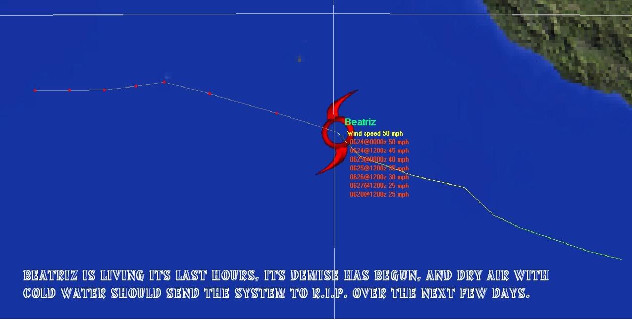
The demise of Beatriz is nearing fast as you can see at water vapor pic.Apart from the dry air cooler waters are not far from where the storm is today so the RIP thing will come very soon from later tonight.
0 likes
Visit the Caribbean-Central America Weather Thread where you can find at first post web cams,radars
and observations from Caribbean basin members Click Here
and observations from Caribbean basin members Click Here
-
cycloneye
- Admin
- Posts: 148856
- Age: 69
- Joined: Thu Oct 10, 2002 10:54 am
- Location: San Juan, Puerto Rico
TROPICAL STORM BEATRIZ (EP022005) ON 20050623 1200 UTC
...00 HRS... ...12 HRS... ...24 HRS... ...36 HRS...
050623 1200 050624 0000 050624 1200 050625 0000
LAT LON LAT LON LAT LON LAT LON
BAMD 16.7N 109.4W 17.6N 112.3W 18.0N 115.0W 18.3N 117.5W
BAMM 16.7N 109.4W 17.7N 112.3W 18.2N 115.0W 18.8N 117.1W
LBAR 16.7N 109.4W 17.6N 111.8W 19.0N 114.4W 20.3N 116.6W
SHIP 45KTS 46KTS 45KTS 41KTS
DSHP 45KTS 46KTS 45KTS 41KTS
...48 HRS... ...72 HRS... ...96 HRS... ..120 HRS...
050625 1200 050626 1200 050627 1200 050628 1200
LAT LON LAT LON LAT LON LAT LON
BAMD 18.6N 119.8W 19.3N 122.6W 19.6N 125.2W 20.2N 128.7W
BAMM 19.1N 118.9W 19.8N 121.3W 20.0N 123.3W 19.9N 126.5W
LBAR 21.3N 118.2W 23.7N 118.6W 27.0N 116.0W 33.1N 113.2W
SHIP 36KTS 24KTS 15KTS 0KTS
DSHP 36KTS 24KTS 15KTS 0KTS
...INITIAL CONDITIONS...
LATCUR = 16.7N LONCUR = 109.4W DIRCUR = 295DEG SPDCUR = 12KT
LATM12 = 15.7N LONM12 = 107.1W DIRM12 = 295DEG SPDM12 = 12KT
LATM24 = 14.8N LONM24 = 104.8W
WNDCUR = 45KT RMAXWD = 20NM WNDM12 = 45KT
CENPRS = 1000MB OUTPRS = 1009MB OUTRAD = 200NM SDEPTH = D
RD34NE = 125NM RD34SE = 40NM RD34SW = 40NM RD34NW = 125NM
No change in strengh for next advisory 45kts.As I said at post above the end of Beatriz is nearing faster as it is moving a bit fast now into cooler ans stable enviroment.
0 likes
Visit the Caribbean-Central America Weather Thread where you can find at first post web cams,radars
and observations from Caribbean basin members Click Here
and observations from Caribbean basin members Click Here
-
HURAKAN

- Professional-Met

- Posts: 46086
- Age: 38
- Joined: Thu May 20, 2004 4:34 pm
- Location: Key West, FL
- Contact:

Tropical Storm Beatriz Discussion Number 8
Statement as of 8:00 am PDT on June 23, 2005
Beatriz appears to have reached peak intensity this morning near 45
kt. A trmm overpass near 07z depicts a sheared system with the
estimated center beneath the eastern side of the deep convection...
which has decreased since 09z. While Dvorak intensity estimates
remain 55 kt...the advisory intensity is held at 45 kt due to the
location of the surface center relative to the deteriorating
convective pattern.
The tropical storm is moving at an estimated 295/12 and should cross
the 26c sea surface isotherm later today...as it enters an
increasingly stable and dry environment. This motion is a little
to the right of the previous forecast track. Time has just about
run out for any further intensification...and given the recent
decrease in convection a weakening trend could be imminent. SHIPS
guidance maintains a tropical storm through 48 hours...while the
GFDL does so only for only 12 more hours. The official intensity
forecast is a blend of these solutions. Beyond about 24
hours...Beatriz should slow down and turn toward the west as the
mid-level ridge to the north breaks down...and the eventual remnant
low should then drift westward along with the low-level trade
winds.
Forecaster Knabb/Beven
forecast positions and Max winds
initial 23/1500z 16.9n 109.9w 45 kt
12hr VT 24/0000z 17.4n 111.6w 45 kt
24hr VT 24/1200z 17.9n 113.5w 40 kt
36hr VT 25/0000z 18.2n 114.8w 35 kt
48hr VT 25/1200z 18.1n 115.6w 30 kt
72hr VT 26/1200z 18.0n 116.5w 25 kt...dissipating
96hr VT 27/1200z 18.0n 117.5w 20 kt...remnant low
120hr VT 28/1200z 18.0n 118.5w 20 kt...remnant low
0 likes


Fuel...
Fire...
Yawn...
Matt-hurricanewatcher wrote:Derek Ortt wrote:of course Matt would know more than everyone els, as he has so demonstrated here all season so far.
In all seriousness Matt, please be respectful of those who have went through the years of training (including those at NHC whom you so love to trash)
Give me a break...I give my option you give yours. Why do you people love to trash/bash me? That is the #$#$%# quastion I went to know. I know the nhc forecasters have years of skills over mine but how did they learn??? Thats right through doing there own forecast plus years of schooling. Also I have more respect for the nhc then for any one on this freaking planet. So please don't stand behind the pro logo in shoot me down like a dog.
I'm really really getting quite sick of it. I'v had a hard day of college. All I feel like doing is relaxing and watching the tropcal cyclone.
Also everything I said the Nhc forecaster Also said. I'm going to get a warning for this or maybe even worst but this is the kind of mood I'm in.
Fire...
Matt,
you are not the only one who has had a rough day. You think running a major computer model is an easy task when things go wrong, when the model should have been running 3 hours previously, and when you have such a severe sleeping problem that you need 10 pills a night to sleep? Please. I'd love to have the "hard" day that you had. I'd trade my stress level for yours any day of the week.
You rolled your eyes at the NHC just because their scientifically based estimate did not agree with yours. That is blatant disrespect, IMO
Yawn...
0 likes
-
cycloneye
- Admin
- Posts: 148856
- Age: 69
- Joined: Thu Oct 10, 2002 10:54 am
- Location: San Juan, Puerto Rico
Down to 40kts at next advisory
TROPICAL STORM BEATRIZ (EP022005) ON 20050623 1800 UTC
...00 HRS... ...12 HRS... ...24 HRS... ...36 HRS...
050623 1800 050624 0600 050624 1800 050625 0600
LAT LON LAT LON LAT LON LAT LON
BAMD 17.0N 110.5W 17.8N 113.0W 18.4N 115.4W 19.0N 117.4W
BAMM 17.0N 110.5W 17.9N 113.0W 18.5N 115.3W 18.9N 117.1W
LBAR 17.0N 110.5W 17.8N 112.7W 18.9N 115.0W 20.0N 117.0W
SHIP 40KTS 38KTS 35KTS 31KTS
DSHP 40KTS 38KTS 35KTS 31KTS
...48 HRS... ...72 HRS... ...96 HRS... ..120 HRS...
050625 1800 050626 1800 050627 1800 050628 1800
LAT LON LAT LON LAT LON LAT LON
BAMD 19.8N 119.1W 20.9N 121.1W 23.4N 122.7W 28.2N 121.6W
BAMM 19.3N 118.8W 19.3N 121.5W 19.9N 124.9W 22.2N 127.0W
LBAR 20.9N 118.4W 22.5N 119.2W 25.2N 117.8W 26.6N 115.1W
SHIP 26KTS 16KTS 0KTS 0KTS
DSHP 26KTS 16KTS 0KTS 0KTS
...INITIAL CONDITIONS...
LATCUR = 17.0N LONCUR = 110.5W DIRCUR = 290DEG SPDCUR = 11KT
LATM12 = 16.2N LONM12 = 108.3W DIRM12 = 295DEG SPDM12 = 12KT
LATM24 = 15.2N LONM24 = 106.0W
WNDCUR = 40KT RMAXWD = 20NM WNDM12 = 45KT
CENPRS = 1002MB OUTPRS = 1010MB OUTRAD = 200NM SDEPTH = D
RD34NE = 100NM RD34SE = 40NM RD34SW = 40NM RD34NW = 100NM
Beatriz is dying.Winds are going down.The end is near.
0 likes
Visit the Caribbean-Central America Weather Thread where you can find at first post web cams,radars
and observations from Caribbean basin members Click Here
and observations from Caribbean basin members Click Here


 now for Beatriz this time.

-
cycloneye
- Admin
- Posts: 148856
- Age: 69
- Joined: Thu Oct 10, 2002 10:54 am
- Location: San Juan, Puerto Rico
Tropical Storm Beatriz Discussion Number 9
Statement as of 2:00 PM PDT on June 23, 2005
afternoon satellite imagery shows that the low-level center of
Beatriz has become exposed east of an area of weak and poorly
organized convection. While satellite intensity estimates remain
55 kt...a 1316z Quikscat overpass showed at best 45 kt winds...
possibly rain-contaminated...in the southwestern quadrant. Based
on the decay in the cloud pattern since then...the initial
intensity is reduced to 40 kt. The storm is moving into cooler
water and should continue to weaken. The intensity forecast is
revised to having Beatriz become a non-convective remnant low in 72
hr...and it may weaken faster than currently forecast.
The initial motion is now 290/11. Beatriz should turn more westward
during the next 48 hr as it weakens and the low-level steering
becomes dominant. Most dynamical guidance turns the remnants of
Beatriz southward after 48 hr in response to another cyclone
forming to the east. Given the uncertainties in forecasting
genesis and in forecasting how close the two systems may be...the
track forecast will call for a more gradual turn toward the
west-southwest after 48 hr.
The wind radii have been revised downward based on the Quikscat
data.
Forecaster Beven
forecast positions and Max winds
initial 23/2100z 17.2n 111.0w 40 kt
12hr VT 24/0600z 17.6n 112.5w 35 kt
24hr VT 24/1800z 17.9n 114.1w 30 kt
36hr VT 25/0600z 18.0n 115.2w 25 kt
48hr VT 25/1800z 18.0n 116.0w 25 kt...dissipating
72hr VT 26/1800z 17.5n 117.0w 20 kt...remnant low
96hr VT 27/1800z 17.5n 118.0w 20 kt...remnant low
120hr VT 28/1800z 17.0n 119.0w 20 kt...remnant low
Bye Bye Betty.
0 likes
Visit the Caribbean-Central America Weather Thread where you can find at first post web cams,radars
and observations from Caribbean basin members Click Here
and observations from Caribbean basin members Click Here
-
cycloneye
- Admin
- Posts: 148856
- Age: 69
- Joined: Thu Oct 10, 2002 10:54 am
- Location: San Juan, Puerto Rico
TROPICAL DEPRESSION BEATRIZ (EP022005) ON 20050624 0000 UTC
...00 HRS... ...12 HRS... ...24 HRS... ...36 HRS...
050624 0000 050624 1200 050625 0000 050625 1200
LAT LON LAT LON LAT LON LAT LON
BAMD 17.1N 111.3W 17.7N 113.5W 18.4N 115.5W 19.0N 117.3W
BAMM 17.1N 111.3W 17.9N 113.2W 18.6N 114.7W 19.0N 116.1W
LBAR 17.1N 111.3W 17.6N 113.3W 18.5N 115.3W 19.4N 117.1W
SHIP 30KTS 25KTS 22KTS 18KTS
DSHP 30KTS 25KTS 22KTS 18KTS
...48 HRS... ...72 HRS... ...96 HRS... ..120 HRS...
050626 0000 050627 0000 050628 0000 050629 0000
LAT LON LAT LON LAT LON LAT LON
BAMD 19.7N 118.8W 21.2N 121.2W 26.8N 120.9W 35.0N 114.9W
BAMM 19.4N 117.4W 19.8N 120.2W 22.0N 122.3W 26.8N 121.3W
LBAR 20.1N 118.4W 21.3N 120.0W 24.0N 120.2W 28.6N 118.5W
SHIP 0KTS 0KTS 0KTS 0KTS
DSHP 0KTS 0KTS 0KTS 0KTS
...INITIAL CONDITIONS...
LATCUR = 17.1N LONCUR = 111.3W DIRCUR = 280DEG SPDCUR = 9KT
LATM12 = 16.7N LONM12 = 109.4W DIRM12 = 291DEG SPDM12 = 11KT
LATM24 = 15.7N LONM24 = 107.1W
WNDCUR = 30KT RMAXWD = 20NM WNDM12 = 40KT
CENPRS = 1005MB OUTPRS = 1010MB OUTRAD = 175NM SDEPTH = M
RD34NE = 0NM RD34SE = 0NM RD34SW = 0NM RD34NW = 0NM
RIP.
0 likes
Visit the Caribbean-Central America Weather Thread where you can find at first post web cams,radars
and observations from Caribbean basin members Click Here
and observations from Caribbean basin members Click Here
-
cycloneye
- Admin
- Posts: 148856
- Age: 69
- Joined: Thu Oct 10, 2002 10:54 am
- Location: San Juan, Puerto Rico
Tropical Depression Beatriz Discussion Number 10
Statement as of 8:00 PM PDT on June 23, 2005
deep convection continues to diminish and what little there is
remains displaced to the west of the circulation center. Dvorak T
and ci numbers from TAFB and SAB suggest that Beatriz has fallen
below tropical storm strength. With the cyclone continuing to move
over sub 26c SSTs...continued weakening is expected...and the
system is expected to degenerate to a remnant low within the next
24 hours.
The initial motion is 280/9. This track is a little to the left of
and slower than the previous motion...and is consistent with the
cyclone decoupling from the upper-level easterlies. Global models
suggest that the low-level environmental current will weaken over
the next couple of days...with the remnants of Beatriz ultimately
pulled southeastward around the disturbance currently south of the
Gulf of Tehuantepec. The official forecast is slower than the
previous advisory...but anticipates that Beatriz will dissipate
before interacting significantly with the trailing disturbance.
Forecaster Franklin
forecast positions and Max winds
initial 24/0300z 17.2n 111.7w 30 kt
12hr VT 24/1200z 17.5n 113.0w 25 kt...dissipating
24hr VT 25/0000z 17.7n 114.2w 20 kt...remnant low
36hr VT 25/1200z 17.7n 115.0w 20 kt...remnant low
48hr VT 26/0000z 17.6n 115.7w 20 kt...remnant low
72hr VT 27/0000z 17.5n 116.5w 20 kt...remnant low
96hr VT 28/0000z...dissipated
TD Beatriz RIP.
0 likes
Visit the Caribbean-Central America Weather Thread where you can find at first post web cams,radars
and observations from Caribbean basin members Click Here
and observations from Caribbean basin members Click Here


Who is online
Users browsing this forum: bird, pepecool20 and 59 guests