SPECIAL FEATURE...
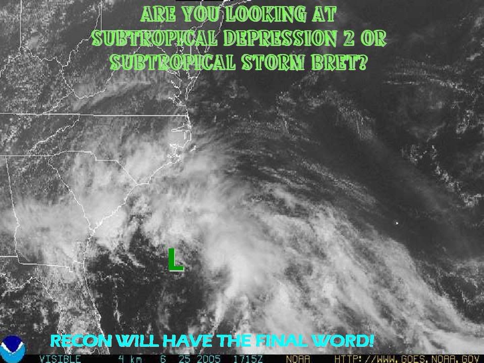
A COMPLEX LOW PRES SYSTEM IS LOCATED E OF THE N COAST OF FLORIDA
AND IS MOVING NNW NEAR 10 KT TOWARDS THE CAROLINA COAST. THE
MAIN CENTER OF LOW PRES...1011 MB...IS CENTERED ABOUT 270 NM E
OF JACKSONVILLE FLORIDA NEAR 30N76W AND IS CONNECTED BY A TROF
TO A SECONDARY 1012 MB LOW ABOUT 75 NM ESE OF JACKSONVILLE.
ANOTHER TROF EXTENDS SW OF THE SECONDARY LOW ACROSS CNTRL
FLORIDA INTO THE E GULF OF MEXICO MARKED BY A DISTINCT NE TO SW
WIND SHIFT. THE SYSTEM HAS A CLASSIC SUBTROPICAL CYCLONE
SIGNATURE...WITH THE CLOUD/RAIN SHIELD WRAPPING FROM THE E TO N
SIDE OF THE LOW AND DRY AIR BEING ADVECTED EWD OVER FLORIDA INTO
THE S SIDE OF THE SYSTEM. WINDS ON THE E SIDE OF THE SYSTEM HAVE
CONTINUED TO INCREASE...AND TROPICAL OR SUBTROPICAL CYCLONE
DEVELOPMENT IS POSSIBLE IN THE NEXT 24 HRS BEFORE THE SYSTEM
MOVES INLAND ALONG THE CAROLINA COAST. AN AIR FORCE
RECONNAISSANCE AIRCRAFT IS SCHEDULED TO INVESTIGATE THE SYSTEM
THIS AFTERNOON TO DETERMINE IF THIS HAS ALREADY OCCURRED.
SCATTERED MODERATE CONVECTION IS E OF THE BAHAMAS FROM 22N-32N
BETWEEN 69W-75W AND SCATTERED SHOWERS/TSTMS ARE FROM 31N-35N
BETWEEN 75W-85W MOVING INLAND ACROSS NORTH CAROLINA...SOUTH
CAROLINA...AND GEORGIA.
The final word will be recon in a couple of hours.
2:05 PM TWD Special Feature=Classic Subtropical signature
Moderator: S2k Moderators
Forum rules

The posts in this forum are NOT official forecasts and should not be used as such. They are just the opinion of the poster and may or may not be backed by sound meteorological data. They are NOT endorsed by any professional institution or STORM2K. For official information, please refer to products from the National Hurricane Center and National Weather Service.
-
cycloneye

- Admin

- Posts: 148856
- Age: 69
- Joined: Thu Oct 10, 2002 10:54 am
- Location: San Juan, Puerto Rico
2:05 PM TWD Special Feature=Classic Subtropical signature
0 likes
Visit the Caribbean-Central America Weather Thread where you can find at first post web cams,radars
and observations from Caribbean basin members Click Here
and observations from Caribbean basin members Click Here


Check out the observations from Station TYBG1 - U.S. Navy Tower R8, about 100 miles east of Savannah, GA.
http://www.ndbc.noaa.gov/station_page.php?station=TYBG1
http://www.ndbc.noaa.gov/show_plot.php?station=tybg1&meas=wdpr&uom=E
Looks like we got at least a depression!!!
http://www.ndbc.noaa.gov/station_page.php?station=TYBG1
http://www.ndbc.noaa.gov/show_plot.php?station=tybg1&meas=wdpr&uom=E
Looks like we got at least a depression!!!
Last edited by jrod on Sat Jun 25, 2005 2:29 pm, edited 1 time in total.
0 likes
-
Brent
- S2K Supporter

- Posts: 38673
- Age: 37
- Joined: Sun May 16, 2004 10:30 pm
- Location: Tulsa Oklahoma
- Contact:
jrod wrote:Check out the observations from Station TYBG1 - U.S. Navy Tower R8, about 150 miles east of Savannah, GA.
http://www.ndbc.noaa.gov/station_page.php?station=TYBG1
http://www.ndbc.noaa.gov/show_plot.php?station=tybg1&meas=wdpr&uom=E
Looks like we got at least a depression!!!
Need a west wind or it doesn't matter.
0 likes
#neversummer
I thought sub-stropical systems dont need the full circle of winds.
The pressure at that station is 1011mb, and it looks like another some what defined swirl 300 miles east of that, I think the pressure is lower and that west wind is over there.
The pressure at that station is 1011mb, and it looks like another some what defined swirl 300 miles east of that, I think the pressure is lower and that west wind is over there.
Last edited by jrod on Sat Jun 25, 2005 2:42 pm, edited 1 time in total.
0 likes

-
cycloneye
- Admin
- Posts: 148856
- Age: 69
- Joined: Thu Oct 10, 2002 10:54 am
- Location: San Juan, Puerto Rico
jrod wrote:Ive seen worse. One year this system in the gulf looked like a front and they were calling it a storm, at least thats how I remember it. It was in the last few years, hopefully someone else knows what I am rambling about.
That was Grace.
0 likes
Visit the Caribbean-Central America Weather Thread where you can find at first post web cams,radars
and observations from Caribbean basin members Click Here
and observations from Caribbean basin members Click Here
-
Brent
- S2K Supporter
- Posts: 38673
- Age: 37
- Joined: Sun May 16, 2004 10:30 pm
- Location: Tulsa Oklahoma
- Contact:
jrod wrote:I thought sub-stropical systems dont need the full circle of winds.
The pressure at that station is 1011mb, and it looks like another some what defined swirl 300 miles east of that, I think the pressure is lower and that west wind is over there.
It still MUST have west winds at the surface to the south of the circulation...
True, a subtropical cyclone has the strongest winds to the north and east of the center, but all they need is a light west wind(or some variation of it, Northwest, Southwest etc.)
0 likes
#neversummer
Brent wrote:jrod wrote:I thought sub-stropical systems dont need the full circle of winds.
The pressure at that station is 1011mb, and it looks like another some what defined swirl 300 miles east of that, I think the pressure is lower and that west wind is over there.
It still MUST have west winds at the surface to the south of the circulation...
True, a subtropical cyclone has the strongest winds to the north and east of the center, but all they need is a light west wind(or some variation of it, Northwest, Southwest etc.)
Agreed Brent - there MUST be a west wind, or it's an open low.
0 likes
Who is online
Users browsing this forum: Ulf and 39 guests