Tropical Depression Calvin
Moderator: S2k Moderators
Forum rules

The posts in this forum are NOT official forecasts and should not be used as such. They are just the opinion of the poster and may or may not be backed by sound meteorological data. They are NOT endorsed by any professional institution or STORM2K. For official information, please refer to products from the National Hurricane Center and National Weather Service.
-
Derek Ortt
-
Brent
- S2K Supporter

- Posts: 38673
- Age: 37
- Joined: Sun May 16, 2004 10:30 pm
- Location: Tulsa Oklahoma
- Contact:
Tropical Depression Three-E Advisory Number 2
Statement as of 8:00 PM PDT on June 26, 2005
...Tropical storm watch issued for a portion of the Mexican coast...
At 8 PM PDT...0300 UTC...the government of Mexico has issued a
tropical storm watch from Lagunas de chacahua westward to Lazaro
Cardenas. A tropical storm watch means that tropical storm
conditions are possible within the watch area...generally within 36
hours.
For storm information specific to your area...including possible
inland watches and warnings...please monitor products issued
by your local weather office.
At 8 PM PDT...0300z...the center of Tropical Depression Three-E was
estimated to be near latitude 14.1 north...longitude 98.0 west or
about 155 miles...255 km...south-southeast of punto maldonado
Mexico and about 230 miles...370 km...south-southeast of Acapulco
Mexico.
The depression has been moving erratically this evening...but is now
estimated to be moving toward the north-northwest near 3 mph
... 6 km/hr. A turn to the northwest...on a course roughly parallel
to the coastline...is expected over the next 12 to 24 hours.
Maximum sustained winds are near 35 mph... 55 km/hr...with higher
gusts. The depression is forecast to become a tropical storm during
the next 24 hours.
Estimated minimum central pressure is 1003 mb...29.62 inches.
Total rainfall accumulations of 2 to 4 inches are expected within
the watch area.
Repeating the 8 PM PDT position...14.1 N... 98.0 W. Movement
toward...north-northwest near 3 mph. Maximum sustained
winds... 35 mph. Minimum central pressure...1003 mb.
An intermediate advisory will be issued by the National
Hurricane Center at 11 PM PDT followed by the next
complete advisory at 2 am PDT.
Forecaster Franklin
0 likes
#neversummer
-
cycloneye

- Admin

- Posts: 148856
- Age: 69
- Joined: Thu Oct 10, 2002 10:54 am
- Location: San Juan, Puerto Rico
Tropical Depression Three-E Forecast/Advisory Number 2
Statement as of 03:00Z on June 27, 2005
at 8 PM PDT...0300 UTC...the government of Mexico has issued a
tropical storm watch from Lagunas de chacahua westward to Lazaro
Cardenas. A tropical storm watch means that tropical storm
conditions are possible within the watch area...generally within 36
hours.
Tropical depression center located near 14.1n 98.0w at 27/0300z
position accurate within 45 nm
present movement toward the north-northwest or 340 degrees at 3 kt
estimated minimum central pressure 1003 mb
Max sustained winds 30 kt with gusts to 40 kt.
Winds and seas vary greatly in each quadrant. Radii in nautical
miles are the largest radii expected anywhere in that quadrant.
Repeat...center located near 14.1n 98.0w at 27/0300z
at 27/0000z center was located near 13.9n 97.9w
forecast valid 27/1200z 14.8n 98.7w
Max wind 40 kt...gusts 50 kt.
34 kt... 50ne 20se 20sw 50nw.
Forecast valid 28/0000z 15.6n 100.5w
Max wind 50 kt...gusts 60 kt.
50 kt... 20ne 0se 0sw 20nw.
34 kt... 75ne 40se 40sw 75nw.
Forecast valid 28/1200z 16.3n 102.7w
Max wind 60 kt...gusts 75 kt.
50 kt... 30ne 0se 0sw 30nw.
34 kt... 90ne 50se 50sw 90nw.
Forecast valid 29/0000z 16.7n 105.0w
Max wind 65 kt...gusts 80 kt.
50 kt... 40ne 20se 15sw 40nw.
34 kt...100ne 60se 60sw 100nw.
Forecast valid 30/0000z 17.0n 109.0w
Max wind 60 kt...gusts 75 kt.
50 kt... 40ne 20se 20sw 40nw.
34 kt...100ne 60se 60sw 100nw.
Extended outlook. Note...errors for track have averaged near 200 nm
on day 4 and 250 nm on day 5...and for intensity near 20 kt each day
outlook valid 01/0000z 17.0n 112.0w
Max wind 40 kt...gusts 50 kt.
Outlook valid 02/0000z 17.0n 114.5w
Max wind 30 kt...gusts 40 kt.
Request for 3 hourly ship reports within 300 miles of 14.1n 98.0w
next advisory at 27/0900z
forecaster Franklin
0 likes
Visit the Caribbean-Central America Weather Thread where you can find at first post web cams,radars
and observations from Caribbean basin members Click Here
and observations from Caribbean basin members Click Here
-
Derek Ortt
WTPZ43 KNHC 270244
TCDEP3
TROPICAL DEPRESSION THREE-E DISCUSSION NUMBER 2
NWS TPC/NATIONAL HURRICANE CENTER MIAMI FL
8 PM PDT SUN JUN 26 2005
THE POSITION OF THE DEPRESSION IS VERY DIFFICULT TO DETERMINE THIS
EVENING...ALTHOUGH AN SSMI PASS AT 0045Z AND THE ACAPULCO RADAR
SUGGEST THAT THE CENTER IS SOUTHEAST OF THE DEEP CONVECTION.
LOCATION UNCERTAINTY CLOUDS THE DVORAK CLASSIFICATIONS...WHICH WERE
2.5 FROM AFWA AND TAFB AND 2.0 FROM SAB. GIVEN THIS UNCERTAINTY...
I PREFER TO HOLD THE INTENSITY ESTIMATE AT 30 KT. ALL MODEL
GUIDANCE SUGGESTS THAT THE CYCLONE WILL STRENGTHEN. IN FACT...THE
GFDL MAKES THE SYSTEM A HURRICANE WITHIN 24 HOURS. THE SHIPS MODEL
IS LESS AGGRESSIVE. THE OFFICIAL FORECAST FOLLOWS A BLEND OF THIS
GUIDANCE BUT SHOULD THE EATERLY SHEAR NOT DIMINISH THIS FORECAST
COULD BE A LITTLE OVERDONE. BY 72 HOURS THE CYCLONE SHOULD BE
REACHING COLDER WATERS.
THE INITIAL MOTION REMAINS UNCERTAIN BUT IS ESTIMATED TO BE 340/3.
WATER VAPOR IMAGERY SHOWS A MID- TO UPPER-LEVEL TROUGH EXTENDING
SOUTHWESTWARD FROM THE WESTERN GULF OF MEXICO...AND THIS TROUGH MAY
BE CONTRIBUTING TO THE RELATIVELY WEAK STEERING CURRENT. MODEL
GUIDANCE SUGGESTS THAT THIS TROUGH SHOULD WEAKEN...AND THAT WITHIN
THE NEXT 24-36 HOURS THE DOMINANT STEERING FEATURE SHOULD BE A
RIDGE OF HIGH PRESSURE OVER WESTERN MEXICO. THIS SHOULD GRADUALLY
BEND THE TRACK OF THE CYCLONE TO THE NORTHWEST AND THEN THE
WEST-NORTHWEST. UNCLEAR AT THIS POINT IS HOW CLOSE TO THE CLOSE
THE CENTER WILL GET. GIVEN THE FORECAST TRACK AND WIND RADII...THE
POSSIBILITY EXISTS FOR TROPICAL STORM FORCE WINDS ALONG THE COAST
AND CONSEQUENTLY A TROPICAL STORM WATCH IS BEING ISSUED AT THIS
TIME.
RAINS FROM THE DEPRESSION ARE ALREADY AFFECTING PORTIONS OF THE
WATCH AREA.
FORECASTER FRANKLIN
FORECAST POSITIONS AND MAX WINDS
INITIAL 27/0300Z 14.1N 98.0W 30 KT
12HR VT 27/1200Z 14.8N 98.7W 40 KT
24HR VT 28/0000Z 15.6N 100.5W 50 KT
36HR VT 28/1200Z 16.3N 102.7W 60 KT
48HR VT 29/0000Z 16.7N 105.0W 65 KT
72HR VT 30/0000Z 17.0N 109.0W 60 KT
96HR VT 01/0000Z 17.0N 112.0W 40 KT
120HR VT 02/0000Z 17.0N 114.5W 30 KT
0 likes
-
cycloneye
- Admin
- Posts: 148856
- Age: 69
- Joined: Thu Oct 10, 2002 10:54 am
- Location: San Juan, Puerto Rico

0 likes
Visit the Caribbean-Central America Weather Thread where you can find at first post web cams,radars
and observations from Caribbean basin members Click Here
and observations from Caribbean basin members Click Here
-
senorpepr

- Military Met/Moderator

- Posts: 12542
- Age: 43
- Joined: Fri Aug 22, 2003 9:22 pm
- Location: Mackenbach, Germany
- Contact:
I've set up the S2K Worldwide Tropical Update to display links for Calvin. Also, I've fixed the NRL Storm Floaters for Calvin. (NRL changed their directories which threw off the link.)
http://tropicalupdates.nhcwx.com/
http://tropicalupdates.nhcwx.com/
0 likes
-
cycloneye
- Admin
- Posts: 148856
- Age: 69
- Joined: Thu Oct 10, 2002 10:54 am
- Location: San Juan, Puerto Rico
000
WTPZ43 KNHC 270834
TCDEP3
TROPICAL STORM CALVIN DISCUSSION NUMBER 3
NWS TPC/NATIONAL HURRICANE CENTER MIAMI FL
2 AM PDT MON JUN 27 2005
THE INITIAL POSITION IS BASED MAINLY ON CONTINUITY WITH THE PREVIOUS
FORECAST TRACK AND EXTRAPOLATION OF MICROWAVE SATELLITE POSITIONS
BETWEEN 00Z AND 05Z. A 27/0449Z AMSU OVERPASS INDICATED THE
LOW-LEVEL CIRCULATION REMAINS TO THE SOUTHEAST OF THE MAIN
CONVECTIVE CLOUD MASS AND THE WELL-DEFINED MID-LEVEL CIRCULATION
CENTER. THE INTENSITY OF 35 KT AND THE DECISION TO NAME THE SYSTEM
TROPICAL STORM CALVIN WAS BASED ON A CONSENSUS DVORAK SATELLITE
CURRENT INTENSITY ESTIMATE OF T2.5/35 KT FROM TAFB...SAB...AND
AFWA...PLUS A UW-CIMSS 3-HR AVERAGE AODT ESTIMATE OF T2.6/36 KT.
THE INITIAL MOTION ESTIMATE IS NOW 330/04. THERE IS NO SIGNIFICANT
CHANGE TO THE REASONING OF THE TWO PREVIOUS FORECAST TRACK
DISCUSSIONS. NHC MODEL GUIDANCE REMAINS REASONABLY CONSISTENT ON
GRADUALLY BUILDING THE MEXICAN SUBTROPICAL RIDGE WESTWARD OVER THE
NEXT 2-3 DAYS...WHICH SHOULD ACT TO TURN CALVIN NORTHWESTWARD LATER
TODAY AND THEN MORE WEST-NORTHWESTWARD AFTER 24 HOURS...ALONG WITH
A GRADUAL INCREASE IN FORWARD SPEED UP TO ABOUT 10 KT. CALVIN IS
EXPECTED TO REACH NEAR-26C SSTS BY 72 HOURS AND SLOWLY BEGIN TO
WEAKEN...AND THEN BE FORCED WESTWARD BY THE LOW-LEVEL EASTERLIES.
THE ENVIRONMENT SURROUNDING CALVIN IS STRIKINGLY SIMILAR TO THAT OF
TS BEATRIZ JUST A FEW DAYS AGO. ANOTHER STRONG CONVECTIVE BURST
WENT OFF NORTHWEST OF THE LOW-LEVEL CENTER BETWEEN 03Z-06Z...BUT
HAS SINCE WEAKENED. OTHER BURSTS WILL LIKELY CONTINUE FOR THE NEXT
FEW DAYS...WITH EACH ONE SLIGHTLY STRENGTHENING THE CYCLONE.
HOWEVER...25 TO 30 KT 300-200 MB EASTERLY WINDS HAVE BEEN AND WILL
LIKELY CONTINUE TO UNDERCUT THE OTHERWISE FAVORABLE OUTFLOW LAYER
AND PRODUCE AT LEAST 15-20 KT OF SHEAR. THE GFDL MODEL IS MUCH
LESS ROBUST THAN ITS PREVIOUS RUNS AND NOW ONLY BRINGS CALVIN UP TO
56 KT IN 24 HOURS. SINCE THIS IS SIMILAR TO THE SHIPS MODEL...THE
INTENSITY FORECAST HAS BEEN TRIMMED BACK SLIGHTLY.
HEAVY RAINS FROM CALVIN ARE ALREADY AFFECTING PORTIONS OF THE
TROPICAL STORM WATCH AREA. SINCE THE CURRENT FORECAST KEEPS ANY
TROPICAL STORM FORCE WINDS JUST OFFSHORE...THE EXISTING WATCH
SHOULD SUFFICE FOR THIS FORECAST PACKAGE.
FORECASTER STEWART
FORECAST POSITIONS AND MAX WINDS
INITIAL 27/0900Z 14.6N 98.4W 35 KT
12HR VT 27/1800Z 15.0N 99.5W 40 KT
24HR VT 28/0600Z 15.6N 101.0W 45 KT
36HR VT 28/1800Z 16.3N 103.1W 50 KT
48HR VT 29/0600Z 16.9N 105.4W 55 KT
72HR VT 30/0600Z 17.5N 109.0W 55 KT
96HR VT 01/0600Z 17.5N 111.5W 40 KT
120HR VT 02/0600Z 17.5N 114.5W 30 KT
They no longer have a hurricane in their forecast.
0 likes
Visit the Caribbean-Central America Weather Thread where you can find at first post web cams,radars
and observations from Caribbean basin members Click Here
and observations from Caribbean basin members Click Here
-
cycloneye
- Admin
- Posts: 148856
- Age: 69
- Joined: Thu Oct 10, 2002 10:54 am
- Location: San Juan, Puerto Rico
Tropical Storm Calvin Intermediate Advisory Number 3a
Statement as of 5:00 am PDT on June 27, 2005
...Calvin moving slowly...heavy rainfall and gusty winds continue
affecting the Mexican coast near Acapulco...
A tropical storm watch is in effect from Lagunas de chacahua
westward to Lazaro Cardenas. A tropical storm watch means that
tropical storm conditions are possible within the watch
area...generally within 36 hours.
For storm information specific to your area...including possible
inland watches and warnings...please monitor products issued by
your local weather office.
At 5 am PDT...1200z...the center of Tropical Storm Calvin was
estimated near latitude 14.7 north... longitude 98.8 west or about
155 miles... 250 km...south-southeast of Acapulco Mexico.
Calvin has been moving erratically...but generally toward the
northwest near 5 mph... 7 km/hr. This general motion is expected
to continue for the next 24 hours. On this track the center of the
storm should move roughly parallel to the coastline today.
Maximum sustained winds are near 40 mph... 65 km/hr...with higher
gusts. Some slow strengthening is forecast during the next 24
hours.
Tropical storm force winds extend outward up to 60 miles
... 95 km...mainly northwest and north of the center.
The estimated minimum central pressure is 1002 mb...29.59 inches.
Total rainfall accumulations of 2 to 4 inches...with isolated
higher amounts over mountainous terrain...are expected within the
watch area.
Repeating the 5 am PDT position...14.7 N... 98.8 W. Movement
toward...northwest near 5 mph. Maximum sustained winds... 40 mph.
Minimum central pressure...1002 mb.
The next advisory will be issued by the National Hurricane Center at
8 am PDT.
Forecaster Pasch
0 likes
Visit the Caribbean-Central America Weather Thread where you can find at first post web cams,radars
and observations from Caribbean basin members Click Here
and observations from Caribbean basin members Click Here
-
cycloneye
- Admin
- Posts: 148856
- Age: 69
- Joined: Thu Oct 10, 2002 10:54 am
- Location: San Juan, Puerto Rico
TROPICAL STORM CALVIN (EP032005) ON 20050627 1200 UTC
...00 HRS... ...12 HRS... ...24 HRS... ...36 HRS...
050627 1200 050628 0000 050628 1200 050629 0000
LAT LON LAT LON LAT LON LAT LON
BAMD 14.6N 98.9W 15.6N 101.0W 16.2N 103.6W 16.8N 106.4W
BAMM 14.6N 98.9W 15.5N 100.7W 16.2N 102.8W 16.6N 105.4W
LBAR 14.6N 98.9W 15.5N 100.5W 16.5N 102.8W 17.6N 105.6W
SHIP 35KTS 41KTS 47KTS 51KTS
DSHP 35KTS 41KTS 47KTS 51KTS
...48 HRS... ...72 HRS... ...96 HRS... ..120 HRS...
050629 1200 050630 1200 050701 1200 050702 1200
LAT LON LAT LON LAT LON LAT LON
BAMD 17.2N 109.7W 18.0N 117.4W 19.6N 125.9W 22.1N 133.1W
BAMM 17.1N 108.6W 18.0N 116.0W 19.2N 124.3W 21.3N 132.1W
LBAR 18.6N 108.8W 21.3N 115.3W 23.7N 120.7W 24.5N 125.0W
SHIP 52KTS 45KTS 37KTS 27KTS
DSHP 52KTS 45KTS 37KTS 27KTS
...INITIAL CONDITIONS...
LATCUR = 14.6N LONCUR = 98.9W DIRCUR = 320DEG SPDCUR = 6KT
LATM12 = 13.9N LONM12 = 97.9W DIRM12 = 334DEG SPDM12 = 4KT
LATM24 = 13.1N LONM24 = 97.8W
WNDCUR = 35KT RMAXWD = 30NM WNDM12 = 30KT
CENPRS = 1002MB OUTPRS = 1008MB OUTRAD = 180NM SDEPTH = D
RD34NE = 50NM RD34SE = 25NM RD34SW = 25NM RD34NW = 50NM
0 likes
Visit the Caribbean-Central America Weather Thread where you can find at first post web cams,radars
and observations from Caribbean basin members Click Here
and observations from Caribbean basin members Click Here
-
cycloneye
- Admin
- Posts: 148856
- Age: 69
- Joined: Thu Oct 10, 2002 10:54 am
- Location: San Juan, Puerto Rico
WTPZ33 KNHC 271429
TCPEP3
BULLETIN
TROPICAL STORM CALVIN ADVISORY NUMBER 4
NWS TPC/NATIONAL HURRICANE CENTER MIAMI FL
8 AM PDT MON JUN 27 2005
...CALVIN A LITTLE STRONGER...MOVING PARALLEL TO THE COAST...LOCALLY
HEAVY RAINS AFFECTING COASTAL MEXICO NEAR ACAPULCO...
A TROPICAL STORM WATCH REMAINS IN EFFECT FROM LAGUNAS DE CHACAHUA
WESTWARD TO LAZARO CARDENAS. A TROPICAL STORM WATCH MEANS THAT
TROPICAL STORM CONDITIONS ARE POSSIBLE WITHIN THE WATCH
AREA...GENERALLY WITHIN 36 HOURS.
FOR STORM INFORMATION SPECIFIC TO YOUR AREA...INCLUDING POSSIBLE
INLAND WATCHES AND WARNINGS...PLEASE MONITOR PRODUCTS ISSUED
BY YOUR LOCAL WEATHER OFFICE.
AT 8 AM PDT...1500Z...THE CENTER OF TROPICAL STORM CALVIN WAS
LOCATED NEAR LATITUDE 14.8 NORTH... LONGITUDE 99.5 WEST OR ABOUT
150 MILES... 235 KM... SOUTH OF ACAPULCO MEXICO.
CALVIN IS MOVING TOWARD THE NORTHWEST NEAR 8 MPH ...13 KM/HR...AND A
GENERALLY WEST-NORTHWESTWARD MOTION IS EXPECTED DURING THE NEXT 24
HOURS. ON THIS TRACK...THE CENTER OF THE STORM WILL CONTINUE TO
MOVE PARALLEL TO THE COAST OF MEXICO TODAY.
MAXIMUM SUSTAINED WINDS HAVE INCREASED TO NEAR 50 MPH... 85
KM/HR...WITH HIGHER GUSTS. SOME ADDITIONAL STRENGTHENING IS
POSSIBLE DURING THE NEXT 24 HOURS.
TROPICAL STORM FORCE WINDS EXTEND OUTWARD UP TO 60 MILES
... 95 KM FROM THE CENTER.
ESTIMATED MINIMUM CENTRAL PRESSURE IS 1000 MB...29.53 INCHES.
TOTAL RAINFALL ACCUMULATIONS OF 1 TO 3 INCHES...WITH LOCALLYISOLATED
HIGHER AMOUNTS OVER MOUNTAINOUS TERRAIN...ARE EXPECTED WITHIN THE
WATCH AREA.
REPEATING THE 8 AM PDT POSITION...14.8 N... 99.5 W. MOVEMENT
TOWARD...NORTHWEST NEAR 8 MPH. MAXIMUM SUSTAINED WINDS... 50 MPH.
MINIMUM CENTRAL PRESSURE...1000 MB.
AN INTERMEDIATE ADVISORY WILL BE ISSUED BY THE NATIONAL HURRICANE
CENTER AT 11 AM PDT FOLLOWED BY THE NEXT COMPLETE ADVISORY AT 2 PM
PDT.
FORECASTER PASCH
Now at 50 mph.
0 likes
Visit the Caribbean-Central America Weather Thread where you can find at first post web cams,radars
and observations from Caribbean basin members Click Here
and observations from Caribbean basin members Click Here
-
cycloneye
- Admin
- Posts: 148856
- Age: 69
- Joined: Thu Oct 10, 2002 10:54 am
- Location: San Juan, Puerto Rico
TCDEP3
TROPICAL STORM CALVIN DISCUSSION NUMBER 4
NWS TPC/NATIONAL HURRICANE CENTER MIAMI FL
8 AM PDT MON JUN 27 2005
ON SATELLITE IMAGES...THE ORGANIZATION OF THE DEEP CONVECTION IS NOT
IMPRESSIVE AT THIS TIME. HOWEVER...RADAR IMAGES FROM THE COMISION
NACIONAL DEL AGUA ACAPULCO REVEAL A RATHER WELL-DEFINED SPIRAL RAIN
BAND STRUCTURE. THE INTENSITY IS INCREASED TO 45 KT FOR THIS
ADVISORY IN AGREEMENT WITH THE LATEST DVORAK ESTIMATES. CALVIN IS
IN A MODERATE EASTERLY SHEAR ENVIRONMENT...SO ONLY SLOW
STRENGTHENING IS EXPECTED. THE OFFICIAL WIND SPEED FORECAST IS
SIMILAR TO THAT FROM THE PREVIOUS PACKAGE AND IS IN GENERAL
AGREEMENT WITH THE SHIPS GUIDANCE. BY 72 HOURS...THE CYCLONE WILL
BEGIN TO MOVE OVER COOLER WATERS...SO WEAKENING IS PROBABLE AFTER
THAT TIME.
CALVIN HAS BEGUN TO TURN TOWARD THE LEFT AND THE MOTION ESTIMATE IS
NOW 310/7. SYNOPTIC REASONING FOR THE TRACK FORECAST IS ABOUT THE
SAME AS IN THE PREVIOUS ADVISORY. A MID-LEVEL RIDGE TO THE NORTH
OF THE TROPICAL CYCLONE SHOULD INDUCE A MOSTLY WEST-NORTHWESTWARD
MOTION UNTIL LATE IN THE PERIOD...WHEN A MORE WESTWARD TRACK OF THE
WEAKENING CYCLONE...FOLLOWING THE LOW-LEVEL EASTERLIES...IS LIKELY.
THE LEFTWARD TURN REDUCES THE THREAT TO THE COAST...AND IF A MORE
WEST-NORTHWESTWARD MOTION IS ESTABLISHED...THE TROPICAL STORM WATCH
COULD BE DISCONTINUED LATER TODAY. LOCALLY HEAVY RAINFALL IS
EXPECTED TO CONTINUE TO AFFECT PORTIONS OF THE SOUTHERN COAST OF
MEXICO TODAY.
FORECASTER PASCH
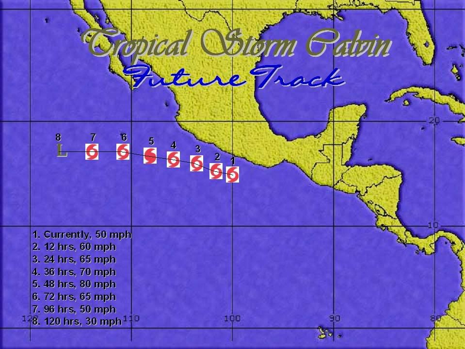
FORECAST POSITIONS AND MAX WINDS
INITIAL 27/1500Z 14.8N 99.5W 45 KT
12HR VT 28/0000Z 15.3N 100.2W 50 KT
24HR VT 28/1200Z 15.9N 102.1W 50 KT
36HR VT 29/0000Z 16.5N 104.3W 55 KT
48HR VT 29/1200Z 17.1N 106.5W 55 KT
72HR VT 30/1200Z 18.0N 110.0W 55 KT
96HR VT 01/1200Z 18.5N 113.5W 35 KT
120HR VT 02/1200Z 18.5N 116.5W 25 KT
TROPICAL STORM CALVIN DISCUSSION NUMBER 4
NWS TPC/NATIONAL HURRICANE CENTER MIAMI FL
8 AM PDT MON JUN 27 2005
ON SATELLITE IMAGES...THE ORGANIZATION OF THE DEEP CONVECTION IS NOT
IMPRESSIVE AT THIS TIME. HOWEVER...RADAR IMAGES FROM THE COMISION
NACIONAL DEL AGUA ACAPULCO REVEAL A RATHER WELL-DEFINED SPIRAL RAIN
BAND STRUCTURE. THE INTENSITY IS INCREASED TO 45 KT FOR THIS
ADVISORY IN AGREEMENT WITH THE LATEST DVORAK ESTIMATES. CALVIN IS
IN A MODERATE EASTERLY SHEAR ENVIRONMENT...SO ONLY SLOW
STRENGTHENING IS EXPECTED. THE OFFICIAL WIND SPEED FORECAST IS
SIMILAR TO THAT FROM THE PREVIOUS PACKAGE AND IS IN GENERAL
AGREEMENT WITH THE SHIPS GUIDANCE. BY 72 HOURS...THE CYCLONE WILL
BEGIN TO MOVE OVER COOLER WATERS...SO WEAKENING IS PROBABLE AFTER
THAT TIME.
CALVIN HAS BEGUN TO TURN TOWARD THE LEFT AND THE MOTION ESTIMATE IS
NOW 310/7. SYNOPTIC REASONING FOR THE TRACK FORECAST IS ABOUT THE
SAME AS IN THE PREVIOUS ADVISORY. A MID-LEVEL RIDGE TO THE NORTH
OF THE TROPICAL CYCLONE SHOULD INDUCE A MOSTLY WEST-NORTHWESTWARD
MOTION UNTIL LATE IN THE PERIOD...WHEN A MORE WESTWARD TRACK OF THE
WEAKENING CYCLONE...FOLLOWING THE LOW-LEVEL EASTERLIES...IS LIKELY.
THE LEFTWARD TURN REDUCES THE THREAT TO THE COAST...AND IF A MORE
WEST-NORTHWESTWARD MOTION IS ESTABLISHED...THE TROPICAL STORM WATCH
COULD BE DISCONTINUED LATER TODAY. LOCALLY HEAVY RAINFALL IS
EXPECTED TO CONTINUE TO AFFECT PORTIONS OF THE SOUTHERN COAST OF
MEXICO TODAY.
FORECASTER PASCH
FORECAST POSITIONS AND MAX WINDS
INITIAL 27/1500Z 14.8N 99.5W 45 KT
12HR VT 28/0000Z 15.3N 100.2W 50 KT
24HR VT 28/1200Z 15.9N 102.1W 50 KT
36HR VT 29/0000Z 16.5N 104.3W 55 KT
48HR VT 29/1200Z 17.1N 106.5W 55 KT
72HR VT 30/1200Z 18.0N 110.0W 55 KT
96HR VT 01/1200Z 18.5N 113.5W 35 KT
120HR VT 02/1200Z 18.5N 116.5W 25 KT
0 likes
Visit the Caribbean-Central America Weather Thread where you can find at first post web cams,radars
and observations from Caribbean basin members Click Here
and observations from Caribbean basin members Click Here
-
cycloneye
- Admin
- Posts: 148856
- Age: 69
- Joined: Thu Oct 10, 2002 10:54 am
- Location: San Juan, Puerto Rico
Tropical Storm Calvin Intermediate Advisory Number 4a
Statement as of 11:00 am PDT on June 27, 2005
...Calvin moving parallel to the coast...locally heavy rains
affecting coastal Mexico near Acapulco...
A tropical storm watch remains in effect from Lagunas de chacahua
westward to Lazaro Cardenas. A tropical storm watch means that
tropical storm conditions are possible within the watch
area...generally within 36 hours.
For storm information specific to your area...including possible
inland watches and warnings...please monitor products issued
by your local weather office.
At 11 am PDT...1800z...the center of Tropical Storm Calvin was
located near latitude 15.1 north... longitude 100.5 west or about
125 miles... 200 km... south-southwest of Acapulco Mexico.
Calvin is moving toward the west-northwest near 12 mph ...19
km/hr...and this motion is expected to continue during the next 24
hours. On this track...the center of the storm will continue to
move parallel to the coast of Mexico today and tonight.
Maximum sustained winds are near 50 mph... 85 km/hr...with higher
gusts. Some additional strengthening is possible during the next 24
hours.
Tropical storm force winds extend outward up to 60 miles
... 95 km from the center.
Estimated minimum central pressure is 1000 mb...29.53 inches.
Total rainfall accumulations of 1 to 3 inches...with locally
higher amounts over mountainous terrain...are expected within the
watch area.
Repeating the 11 am PDT position...15.1 N... 100.5 W. Movement
toward...west-northwest near 12 mph. Maximum sustained winds... 50
mph. Minimum central pressure...1000 mb.
The next advisory will be issued by the National Hurricane Center at
2 PM PDT.
Forecaster Pasch
0 likes
Visit the Caribbean-Central America Weather Thread where you can find at first post web cams,radars
and observations from Caribbean basin members Click Here
and observations from Caribbean basin members Click Here
-
cycloneye
- Admin
- Posts: 148856
- Age: 69
- Joined: Thu Oct 10, 2002 10:54 am
- Location: San Juan, Puerto Rico
TROPICAL STORM CALVIN (EP032005) ON 20050627 1800 UTC
...00 HRS... ...12 HRS... ...24 HRS... ...36 HRS...
050627 1800 050628 0600 050628 1800 050629 0600
LAT LON LAT LON LAT LON LAT LON
BAMD 15.2N 100.5W 15.9N 103.0W 16.5N 105.8W 17.0N 108.9W
BAMM 15.2N 100.5W 15.9N 102.5W 16.4N 104.9W 16.9N 107.6W
LBAR 15.2N 100.5W 15.9N 102.5W 16.9N 105.2W 18.0N 108.3W
SHIP 45KTS 57KTS 64KTS 65KTS
DSHP 45KTS 57KTS 64KTS 65KTS
...48 HRS... ...72 HRS... ...96 HRS... ..120 HRS...
050629 1800 050630 1800 050701 1800 050702 1800
LAT LON LAT LON LAT LON LAT LON
BAMD 17.4N 112.4W 18.1N 120.3W 20.1N 128.4W 23.7N 134.2W
BAMM 17.3N 110.9W 17.7N 118.2W 18.7N 126.2W 20.8N 133.2W
LBAR 19.1N 111.5W 21.4N 118.0W 22.8N 123.4W .0N .0W
SHIP 63KTS 46KTS 29KTS 18KTS
DSHP 63KTS 46KTS 29KTS 18KTS
...INITIAL CONDITIONS...
LATCUR = 15.2N LONCUR = 100.5W DIRCUR = 300DEG SPDCUR = 9KT
LATM12 = 14.5N LONM12 = 98.6W DIRM12 = 299DEG SPDM12 = 9KT
LATM24 = 13.5N LONM24 = 97.9W
WNDCUR = 45KT RMAXWD = 30NM WNDM12 = 35KT
CENPRS = 1000MB OUTPRS = 1008MB OUTRAD = 180NM SDEPTH = D
RD34NE = 50NM RD34SE = 30NM RD34SW = 30NM RD34NW = 50NM
18:00z Models.
0 likes
Visit the Caribbean-Central America Weather Thread where you can find at first post web cams,radars
and observations from Caribbean basin members Click Here
and observations from Caribbean basin members Click Here


-
HURAKAN

- Professional-Met

- Posts: 46086
- Age: 38
- Joined: Thu May 20, 2004 4:34 pm
- Location: Key West, FL
- Contact:
The following post is NOT an official forecast and should not be used as such. It is just the opinion of the poster and may or may not be backed by sound meteorological data. It is NOT endorsed by any professional institution including storm2k.org For Official Information please refer to the NHC and NWS products.
0 likes
Who is online
Users browsing this forum: bird, pepecool20 and 58 guests