Here is the latest track
http://weather.net-waves.com/model.php
IF it doe's not go to the page press 95L.
Invest 95L is up!!!!
Moderator: S2k Moderators
Forum rules

The posts in this forum are NOT official forecasts and should not be used as such. They are just the opinion of the poster and may or may not be backed by sound meteorological data. They are NOT endorsed by any professional institution or STORM2K. For official information, please refer to products from the National Hurricane Center and National Weather Service.


-
Matt-hurricanewatcher
-
Matt-hurricanewatcher
http://weather.noaa.gov/weather/current/MMMT.html
Wind from the NNW (330 degrees) at 12 MPH (10 KT)
Sky conditions overcast
Pressure (altimeter) 29.84 in. Hg (1010 hPa)
ob MMMT 280145Z 33010KT 7SMBKN015 OVC03026/24 A2984 RMK 8/7// RA VC VARBS CONDS
--------------------------------------------------------------------------------
West wind has been reported to the southwest of the center. This is real close. 12 mph...
Yet another station reporting northwest southwest of the center. Fairly weak but there it is.
http://www.wunderground.com/global/stations/76741.html
This reporting station is a long ways from the LLC to the southwest. But this shows how strong the LLC is getting its winds have turned out of the northwest.
http://weather.noaa.gov/weather/current/MMVR.html
0 likes


I would say it is very interesting. I just want to wait and see what the NHC has to say about it. I think they will say it has become better organized. I just don't think they will even consider upgrading until they get at least some Visible Images in. Maybe even a Recon plane. JMHO 
Last edited by mobilebay on Tue Jun 28, 2005 2:35 am, edited 1 time in total.
0 likes
-
Matt-hurricanewatcher
There is more then enough buoys/obs to show that there is a surface low under that convection. I can't wait to read the nhc my self.
Also they have upgraded for much less. Like tropical depressoin 9 of a few years ago south of hati. One ship reported a west wind they upgraded based on that. A few hours later it was found to be bad. This is soild here... http://weather.unisys.com/hurricane/atl ... /track.gif
Also they have upgraded for much less. Like tropical depressoin 9 of a few years ago south of hati. One ship reported a west wind they upgraded based on that. A few hours later it was found to be bad. This is soild here... http://weather.unisys.com/hurricane/atl ... /track.gif
Last edited by Matt-hurricanewatcher on Tue Jun 28, 2005 2:38 am, edited 1 time in total.
0 likes
Matt-hurricanewatcher wrote:There is more then enough buoys/obs to show that there is a surface low under that convection. I can't wait to read the nhc my self.
Also they have upgraded for much less. Like tropical depressoin 9 of a few years ago south of hati. One ship reported a west wind they upgraded based on that. A few hours later it was found to be bad. This is soild here...
I think there is enough evidence to deduce we have a broad area of Low pressure. I'm not sure if that buoy data is enough to say we have a CLOSED low level Circulation.
0 likes
-
Matt-hurricanewatcher
-
Anonymous
~Floydbuster wrote:Yes...but it had a CLOSED CENTER. Time will tell on this one, but I highly highly doubt any kind of upgrade at 5am or 11am.
I strongly agree Floydbuster.
0 likes
-
Matt-hurricanewatcher
I hate to say it but you guys are most likely right...
The quickscats show 30 to 35 mph winds near the center... This is a little old around 23Z. Its past 6z now...The reports of west winds in the center has moved northwestward since then.
https://www.fnmoc.navy.mil/CGI/scat_hir ... 0_-100.gif
You can watch this....
http://www.oceanweather.com/data/
The quickscats show 30 to 35 mph winds near the center... This is a little old around 23Z. Its past 6z now...The reports of west winds in the center has moved northwestward since then.
https://www.fnmoc.navy.mil/CGI/scat_hir ... 0_-100.gif
You can watch this....
http://www.oceanweather.com/data/
0 likes

Usually Tropical Cyclones with any sort of closed low, will show it on the wave patterns of the sea surface...
http://www.oceanweather.com/data/Gulf-o ... index.html
There is nothing there...
Also None of the high resolution models are showing this materializing into anything other than some rain. The synoptics don't support this going anywhere other than AL, Fl panhandle. Between the blocking high over texas, and the bermuda high extending over fl pen.
I just wish the rain would stop.
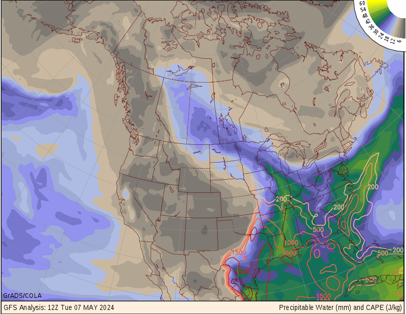
I was looking at some graphics on precipitable water... and look at florida. There is some crazy amounts of water in the atmosphere, this rain has caused central/south florida to simply become a link between the atlantic and gulf.
http://wxmaps.org/pix/avnmr6.00hr.png
-Eric
EDIT:
Matt we think somewhat alike... i left my reply open while looking up some things, and in the process you post a link to the same wave data. lol
http://www.oceanweather.com/data/Gulf-o ... index.html
There is nothing there...
Also None of the high resolution models are showing this materializing into anything other than some rain. The synoptics don't support this going anywhere other than AL, Fl panhandle. Between the blocking high over texas, and the bermuda high extending over fl pen.
I just wish the rain would stop.
I was looking at some graphics on precipitable water... and look at florida. There is some crazy amounts of water in the atmosphere, this rain has caused central/south florida to simply become a link between the atlantic and gulf.
http://wxmaps.org/pix/avnmr6.00hr.png
-Eric
EDIT:
Matt we think somewhat alike... i left my reply open while looking up some things, and in the process you post a link to the same wave data. lol
Last edited by ericinmia on Tue Jun 28, 2005 3:50 am, edited 1 time in total.
0 likes
-
Matt-hurricanewatcher

-
Matt-hurricanewatcher
Matt-hurricanewatcher wrote:First of all I would never ever look at the first link unless it was a cat3 or higher. I watch the wind field on the buoys/obs for these. This also has a broad area of 20 to 25 mph winds under the convection.
Obviously, but anything that could possibly translate into a TS, or even a defined depression would show up on those wave maps. They are also good when there are no bouy's around.
0 likes
Matt-hurricanewatcher wrote:Most buoys only shown winds of 20 to 30 mph with in Arlene. Its only with in a small area doe's the strognest winds happen. In no recon for this as of yet.
True about Arlene. However, they waited until recon got their before upgrading. That's all we are trying to say here. The NHC will be the first to admit it is hard trying to find an LLC on nightime Imagery.
0 likes
also TAFB is still not analyzing a low in the BOC. If this is true and there is still no low, this thing has a long way to go. We will see what the NHC has to say in a few minutes. It still looks like the southern end of a trough to me. By the way, This is the just released 06Z surface map.
http://www.nhc.noaa.gov/tafb_latest/WATL_latest.gif
http://www.nhc.noaa.gov/tafb_latest/WATL_latest.gif
0 likes
-
Matt-hurricanewatcher
Who is online
Users browsing this forum: Ulf and 39 guests