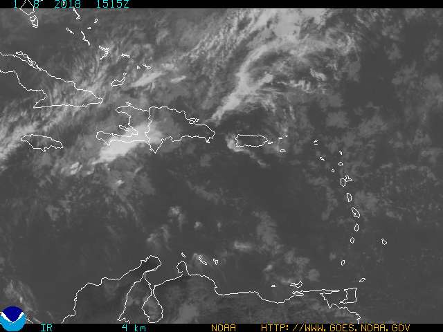
EAST CARIBBEAN TROPICAL WAVE HAS MOVED OVER THE MONA PASSAGE
ALONG 67W/68W S OF 22N MOVING W 10-15 KT. THE WAVE HAS BEEN
INTERACTING WITH A LARGE AND STRONG UPPER LOW CURRENTLY LOCATED
NEAR JAMAICA WITH THE WLY FLOW ON THE UNDERSIDE OF THIS FEATURE
DECELERATING THE WAVE'S OVERALL MOVEMENT. SAN JUAN UPPER AIR
DATA CLEARLY SHOWS THE MID/UPPER PART OF THE LOW PASSING PUERTO
RICO EARLY ON MON...AND THE ACTUAL WAVE (BELOW 850 MB) PASSING
BEFORE 12Z THIS MORNING. THIS APPEARS TO MATCH WELL WITH
CURVATURE OBSERVED IN THE CLOUD/CONVECTIVE ELEMENTS IN VISIBLE
IMAGERY. STRONG DIFFLUENCE E OF THE UPPER LOW IS INDUCING
NUMEROUS MODERATE/STRONG CONVECTION FROM 16N-23N BETWEEN 61W-72W
SPREADING FROM ABOUT ST. KITTS AND BARBUDA WWD TO HISPANIOLA.
SAN JUAN RADAR CURRENTLY SHOWS MODERATE SHOWERS OVER PUERTO RICO
AND THE VIRGIN ISLANDS BUT A LINE OF HEAVY SHOWERS/TSTMS TO THE
S IS SPREADING N OVER ST. CROIX AND WILL BE OVER ST. THOMAS...
CULEBRA...VIEQUES...AND PUERTO RICO OVER THE NEXT SEVERAL HOURS.
HEAVY SHOWERS/TSTMS ARE EXPECTED TO CONTINUE MOVING W...
SPREADING OVER THE BAHAMAS...CUBA...JAMAICA...AND S FLORIDA WED
THROUGH FRI.
Ex 99 affects Puerto Rico,Moving away from PR (Edited Title)
Moderator: S2k Moderators
Forum rules

The posts in this forum are NOT official forecasts and should not be used as such. They are just the opinion of the poster and may or may not be backed by sound meteorological data. They are NOT endorsed by any professional institution or STORM2K. For official information, please refer to products from the National Hurricane Center and National Weather Service.
-
cycloneye

- Admin

- Posts: 148840
- Age: 69
- Joined: Thu Oct 10, 2002 10:54 am
- Location: San Juan, Puerto Rico
0 likes
Visit the Caribbean-Central America Weather Thread where you can find at first post web cams,radars
and observations from Caribbean basin members Click Here
and observations from Caribbean basin members Click Here

-
cycloneye
- Admin
- Posts: 148840
- Age: 69
- Joined: Thu Oct 10, 2002 10:54 am
- Location: San Juan, Puerto Rico
URGENT - IMMEDIATE BROADCAST REQUESTED
FLOOD WATCH
NATIONAL WEATHER SERVICE SAN JUAN PR
817 PM AST TUE JUL 19 2005
...FLASH FLOOD WATCH IN EFFECT FROM THIS EVENING TO EARLY
WEDNESDAY...
...THE NATIONAL WEATHER SERVICE IN SAN JUAN HAS ISSUED A FLASH FLOOD
WATCH EFFECTIVE UNTIL 400 AM AST WEDNESDAY MORNING. THE WATCH
INCLUDES THE FOLLOWING AREAS...
IN PUERTO RICO...
CENTRAL INTERIOR...EASTERN INTERIOR...MAYAGUEZ AND VICINITY...NORTH
CENTRAL...NORTHEAST...PONCE AND VICINITY...SAN JUAN AND VICINITY...
SOUTHEAST...SOUTHWEST AND WESTERN INTERIOR.
INCLUDING THE FOLLOWING COUNTIES
IN PUERTO RICO
DORADO...CANOVANAS...HORMIGUEROS...GUANICA...CAROLINA...
CIALES...CAGUAS...CIDRA...COAMO...CAYEY...COROZAL...MANATI...
FLORIDA...COMERIO...GUAYANILLA...AIBONITO...AGUAS BUENAS...
ARROYO...BARRANQUITAS...BARCELONETA...JUNCOS...JAYUYA...
GURABO...ADJUNTAS...LUQUILLO...PATILLAS...MAUNABO...MARICAO...
OROCOVIS...NAGUABO...NARANJITO...MOROVIS...SAN JUAN...TOA
ALTA...SABANA GRANDE...SAN GERMAN...SAN LORENZO...SAN
SEBASTIAN...YABUCOA...UTUADO...YAUCO...VILLALBA...TRUJILLO
ALTO...VEGA ALTA...LAS PIEDRAS...LAS MARIAS...LARES...BAYAMON...
CEIBA...PENUELAS...GUAYAMA...FAJARDO...HUMACAO...JUANA DIAZ...
GUAYNABO...MAYAGUEZ...PONCE...ARECIBO...CABO ROJO...CATANO...
VEGA BAJA...SALINAS...SANTA ISABEL...LOIZA...RIO GRANDE...TOA
BAJA AND LAJAS
THIS WATCH ALSO INCLUDES ALL RIVERS...STREAMS AND TRIBUTARIES WITHIN
THE WATCH AREA.
AT 812 PM AST WEATHER SERVICE DOPPLER RADAR INDICATED SHOWERS AND
THUNDERSTORMS...SOME WITH VERY HEAVY RAIN OVER THE CARIBBEAN WATERS
AND MOVING NORTHWEST TOWARD PUERTO RICO. HEAVY RAINFALL HAS ALREADY
FALLEN DURING THIS TUESDAY AFTERNOON ACROSS MUCH OF THE ISLAND AND
GROUNDS REMAIN NEAR OR AT SATURATION. ALSO...MANY RIVERS ARE STILL
HIGH AND ADDITIONAL HEAVY RAINFALL MAY PRODUCE FLASH FLOODING OF
THESE RIVERS AND OTHER VULNERABLE AREAS. IN ADDITION...MUDSLIDES ARE
POSSIBLE OVER AREAS OF STEEP TERRAIN.
A FLASH FLOOD WATCH MEANS THAT CONDITIONS ARE FAVORABLE FOR HEAVY
RAIN ACROSS THE WATCH AREA...WHICH MAY LEAD TO FLOODING. IF YOU ARE
IN THE WATCH AREA...CHECK YOUR PREPAREDNESS REQUIREMENTS...ESPECIALLY
IF YOU HAVE INTERESTS ALONG AREA RIVERS. KEEP INFORMED...AND BE READY
FOR QUICK ACTION IF FLOODING IS OBSERVED OR IF A FLASH FLOOD WARNING
IS ISSUED.
BE ESPECIALLY CAUTIOUS AT NIGHT WHEN IT IS HARDER TO RECOGNIZE THE
DANGERS OF FLASH FLOODS. IF FLASH FLOODING IS OBSERVED...ACT
QUICKLY. MOVE TO HIGHER GROUND TO ESCAPE FLOOD WATERS. DO NOT STAY
IN AREAS SUBJECT TO FLOODING WHEN WATER BEGINS RISING.
DO NOT DRIVE YOUR VEHICLE INTO AREAS WHERE THE WATER COVERS THE
ROADWAY. THE WATER DEPTH MAY BE TOO GREAT TO ALLOW YOUR CAR TO CROSS
SAFELY. VEHICLES CAUGHT IN RISING WATER SHOULD BE ABANDONED QUICKLY.
IF YOUR VEHICLE STALLS...ABANDON IT AND SEEK HIGHER GROUND
IMMEDIATELY. RAPIDLY RISING WATER MAY ENGULF YOUR VEHICLE AND ITS
OCCUPANTS AND SWEEP THEM AWAY. MOVE TO HIGHER GROUND.
STAY TUNED TO NOAA WEATHER RADIO...LOCAL TV...RADIO OR YOUR CABLE
TELEVISION PROVIDER FOR LATER STATEMENTS AND POSSIBLE WARNINGS.
THIS PRODUCT...ALONG WITH OTHER WEATHER...HYDROLOGICAL AND CLIMATE
INFORMATION...IS AVAILABLE ON THE WEB AT HTTP://WWW.SRH.NOAA.GOV/SJU
OR AT HTTP://WEATHER.GOV.
$$
ASL/BCS
Here we go with the watch for all of Puerto Rico.
0 likes
Visit the Caribbean-Central America Weather Thread where you can find at first post web cams,radars
and observations from Caribbean basin members Click Here
and observations from Caribbean basin members Click Here
-
wxwatcher91

- Category 5

- Posts: 1606
- Joined: Wed Jul 06, 2005 2:43 pm
- Location: Keene, NH
- Contact:

-
knotimpaired

- Category 1

- Posts: 495
- Joined: Fri May 20, 2005 4:14 am
- Location: Vieques, PR
- Contact:
It appears our small island as well as our sister island have been paying a bit more attention looking after family and friends in Tulum and Puerto Aventuras as well as St Patricks in Grenada.
We my friends are getting hammered by a system we did not pay attention to.
http://www.playacofi.com will record our observations for those interested.
We my friends are getting hammered by a system we did not pay attention to.
http://www.playacofi.com will record our observations for those interested.
0 likes
-
wxwatcher91
- Category 5
- Posts: 1606
- Joined: Wed Jul 06, 2005 2:43 pm
- Location: Keene, NH
- Contact:


-
cycloneye
- Admin
- Posts: 148840
- Age: 69
- Joined: Thu Oct 10, 2002 10:54 am
- Location: San Juan, Puerto Rico
caribepr wrote:We really haven't gotten much here, a lot of wind, some brief heavy showers and lots of prolonged light showers, with lightening and thunder now ... naturally my crazy landlord is out sailing...
Wow in mainland PR it has been a very stormy afternoon and night with the thunder,lighting display,gusty winds and heavy rains.Wow yes crazy to be sailing tonight.
0 likes
Visit the Caribbean-Central America Weather Thread where you can find at first post web cams,radars
and observations from Caribbean basin members Click Here
and observations from Caribbean basin members Click Here
-
mike18xx
It's looking as good as it is right now because it's also under an ample amount of divergence aloft, which can serve to focus and concentrate surface convergence (in turn resulting in LLCCs which persist until changing conditions aloft enable further development as a tropical entity).wxwatcher91 wrote:I'm suprised it's looking as good as it is right now... 99L is under an ample amount of shear...
0 likes


cycloneye wrote:caribepr wrote:We really haven't gotten much here, a lot of wind, some brief heavy showers and lots of prolonged light showers, with lightening and thunder now ... naturally my crazy landlord is out sailing...
Wow in mainland PR it has been a very stormy afternoon and night with the thunder,lighting display,gusty winds and heavy rains.Wow yes crazy to be sailing tonight.
Yep...wonderful guy but he's nuts. I call him my psycho landlord, he calls me his little sharecropper.
Rain has been steady since I last wrote, those big fat drops, but not heavy pounding. Should be good sleeping weather!
0 likes
-
Hurricaneman

- Category 5
- Posts: 7404
- Age: 45
- Joined: Tue Aug 31, 2004 3:24 pm
- Location: central florida
Well, we went from a "prolonged light rain" to howling, lashing, wind, thunder and lightening filled weather sometime in the wee hours that had me closing windows on the *wrong* side of the house (and had RatCat acting like a barnacle on me). Now back to steady light rain. Should be an incredibly muddy little island by now...
0 likes
-
Big-Iguana
-
cycloneye
- Admin
- Posts: 148840
- Age: 69
- Joined: Thu Oct 10, 2002 10:54 am
- Location: San Juan, Puerto Rico
Light rain has been falling in San Juan this morning as it seems the worse is over for us.Still flash flood watches and warnings are up as any additional rain will cause flooding as the grounds are oversaturated.
0 likes
Visit the Caribbean-Central America Weather Thread where you can find at first post web cams,radars
and observations from Caribbean basin members Click Here
and observations from Caribbean basin members Click Here
-
cycloneye
- Admin
- Posts: 148840
- Age: 69
- Joined: Thu Oct 10, 2002 10:54 am
- Location: San Juan, Puerto Rico
AFDSJU
AREA FORECAST DISCUSSION
NATIONAL WEATHER SERVICE SAN JUAN PR
349 AM AST WED JUL 20 2005
.DISCUSSION...NUMEROUS SHOWERS AND ISOLATED TO SCATTERED
THUNDERSTORMS HAVE CONTINUED TO AFFECT OUR LOCAL FORECAST AREA. A
LINE OF HEAVY SHOWERS STARTED TO AFFECT THE USVI AT AROUND
MIDNIGHT...THESE SHOWERS CONTINUED TO MOVE WEST REACHING PUERTO RICO
AT AROUND 2 AM. THESE THUNDERSTORMS HAVE PRODUCED RAINFALL
ACCUMULATION OF BETWEEN 2 TO 4 INCHES OVERNIGHT.
OUR REGION STILL IS UNDER THE INFLUENCE OF A TUTT CENTERED WEST OF
HISPANIOLA...PRODUCING A NORTHWARD UPPER FLOW OVER PUERTO RICO AND
THE U.S. VIRGIN ISLANDS. ALSO A TROPICAL WAVE NOW LOCATED SOUTHWEST
OF PUERTO RICO HAD BROUGHT ENOUGH MOISTURE ACROSS THE REGION TO FUEL
THE INSTABILITY PRODUCED BY THE TUTT. THIS WEATHER PATTERN IS
EXPECTED TO CONTINUE TODAY WITH SCATTERED TO NUMEROUS SHOWERS AND
ISOLATED THUNDERSTORMS DEVELOPING OVER OUR LOCAL AREA.
MODELS ARE SUGGESTING A DRIER CONDITIONS ON THURSDAY AND FRIDAY. ON
FRIDAY AFTERNOON ANOTHER WAVE IS EXPECTED TO MOVE OVER THE ISLANDS
INCREASING SHOWER AND CLOUD COVERAGE THROUGH AT LEAST SATURDAY NIGHT.
Drier trend comming thursday but another wave will arrive by late friday.
0 likes
Visit the Caribbean-Central America Weather Thread where you can find at first post web cams,radars
and observations from Caribbean basin members Click Here
and observations from Caribbean basin members Click Here
-
Hyperstorm

- Category 5
- Posts: 1500
- Joined: Sun Sep 07, 2003 3:48 am
- Location: Ocala, FL

Who is online
Users browsing this forum: MadaTheConquistador and 123 guests