11:30 AM TWO for 90L and caribbean,Recon going to 90L
Moderator: S2k Moderators
Forum rules

The posts in this forum are NOT official forecasts and should not be used as such. They are just the opinion of the poster and may or may not be backed by sound meteorological data. They are NOT endorsed by any professional institution or STORM2K. For official information, please refer to products from the National Hurricane Center and National Weather Service.

-
Stormcenter
- S2K Supporter

- Posts: 6689
- Joined: Wed Sep 03, 2003 11:27 am
- Location: Houston, TX
-
PTrackerLA

- Category 5

- Posts: 5281
- Age: 42
- Joined: Thu Oct 10, 2002 8:40 pm
- Location: Lafayette, LA
Go to this site :http://weather.msfc.nasa.gov/GOES/goeseastconus.html
Click animate, select the number of images, select medium zoom, and click on the system and it should bring up the same shot just animated.
Click animate, select the number of images, select medium zoom, and click on the system and it should bring up the same shot just animated.
0 likes

i have a question about the current steering patterns that may or may not affect 90L. I just had the Miami radar up and it shows thunderstroms moving into martin and palm beach counties. The motion of these storms was due west. Are the motion of these storms (which i assume are under generally the same steering influences as 90L) indicative of how 90L may move
0 likes
-
Hurricaneman

- Category 5
- Posts: 7404
- Age: 45
- Joined: Tue Aug 31, 2004 3:24 pm
- Location: central florida
-
PTrackerLA
- Category 5
- Posts: 5281
- Age: 42
- Joined: Thu Oct 10, 2002 8:40 pm
- Location: Lafayette, LA
-
x-y-no

- Category 5
- Posts: 8359
- Age: 65
- Joined: Wed Aug 11, 2004 12:14 pm
- Location: Fort Lauderdale, FL
Oh, yeah ... there's a closed circulation there alright ...
About 24.9N 74.9W
Can't swear it's at the surface (could still be mid-level) but if it's not there yet I think it will be soon.
I can't see this turning west sharply enough to affect South Florida - just not enough ridging there for that. Everyone from Central Florida through the Carolinas needs to keep an eye on this, though.
Jan
0 likes

-
Derek Ortt
-
Brent
- S2K Supporter
- Posts: 38666
- Age: 37
- Joined: Sun May 16, 2004 10:30 pm
- Location: Tulsa Oklahoma
- Contact:
x-y-no wrote:Oh, yeah ... there's a closed circulation there alright ...
About 24.9N 74.9W
Can't swear it's at the surface (could still be mid-level) but if it's not there yet I think it will be soon.
I can't see this turning west sharply enough to affect South Florida - just not enough ridging there for that. Everyone from Central Florida through the Carolinas needs to keep an eye on this, though.
Jan
Yeah... I was just looking at NRL and the circulation is defintely where you say.
0 likes
#neversummer
-
Rainband
The latest floater loop shows the convection dying down. There are shower and T/S developing east of florida.. If you look at the flow it's from the east. A weaker system will move more west before the ..predicted..curve shown from the models. This will be interesting over the next 24 hours.
0 likes
-
Brent
- S2K Supporter
- Posts: 38666
- Age: 37
- Joined: Sun May 16, 2004 10:30 pm
- Location: Tulsa Oklahoma
- Contact:
Rainband wrote:The latest floater loop shows the convection dying down. There are shower and T/S developing east of florida.. If you look at the flow it's from the east. A weaker system will move more west before the ..predicted..curve shown from the models. This will be interesting over the next 24 hours.
Diurnal minimum??? Emily did this when she was weak early on as well.
0 likes
#neversummer
-
mf_dolphin

- Category 5
- Posts: 17758
- Age: 69
- Joined: Tue Oct 08, 2002 2:05 pm
- Location: St Petersburg, FL
- Contact:
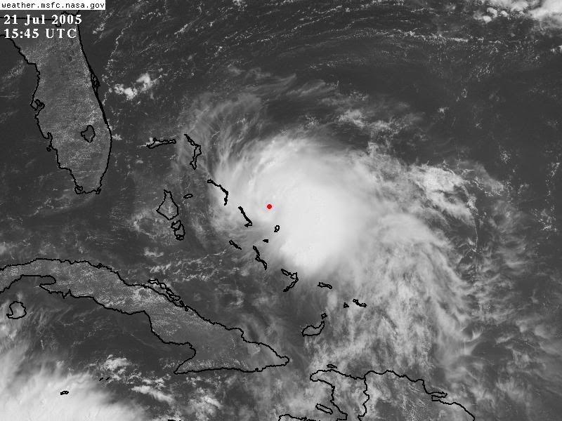
The latest visible shot shows a clear circulation. Best shot I've seen so far of it at least.
http://www.ssd.noaa.gov/PS/TROP/DATA/RT ... -loop.html
http://www.ssd.noaa.gov/PS/TROP/DATA/RT ... -loop.html
0 likes
-
cycloneye

- Admin

- Posts: 148837
- Age: 69
- Joined: Thu Oct 10, 2002 10:54 am
- Location: San Juan, Puerto Rico
mf_dolphin wrote:The latest visible shot shows a clear circulation. Best shot I've seen so far of it at least.
http://www.ssd.noaa.gov/PS/TROP/DATA/RT ... -loop.html
No doubt this will be classified this afternoon a TD or maybe a TS if recon finds strong TS force winds.
0 likes
Visit the Caribbean-Central America Weather Thread where you can find at first post web cams,radars
and observations from Caribbean basin members Click Here
and observations from Caribbean basin members Click Here
Who is online
Users browsing this forum: No registered users and 85 guests