Why Franklin may LOOP after all

This is the general tropical discussion area. Anyone can take their shot at predicting a storms path.

Moderator: S2k Moderators

Forum rules

The posts in this forum are NOT official forecasts and should not be used as such. They are just the opinion of the poster and may or may not be backed by sound meteorological data. They are NOT endorsed by any professional institution or STORM2K. For official information, please refer to products from the National Hurricane Center and National Weather Service.

Help Support Storm2K
Message
Author
mike18xx

#221 Postby mike18xx » Mon Jul 25, 2005 7:20 pm

Air Force Met wrote:
mike18xx wrote:
dhweather wrote:Franklin is going to die. Much sooner than later. I'm planning the services now. :lol:
I have never seen a LLC die over warm water in the Atlantic unless it was shredded by an easterly surge (and all of these cases involve Cape Verde systems traveling west in excess of 20mph).
I see I left that a little too open-ended of a statement; let's address each of the special cases:
Roxanne...1995. Died over the BOC after sitting there for too long....and was a very frustrating storm to forecast. Roxannes spin itself so long it upwelled.
Late October storm; was hurricane twice in BoC; moved due south as exposed TD swirl to died very close to the southern coast of BoC. (IIRC, bone-dry autumnal cold continental high over US was surging south across Gulf.)
Grace in '97 got sheared to death and died a naked swirl.
Mid-October sub-tropical transformer; IMO the swirl would have survived if Hispanola hadn't been in the way.
Debbie in '94 died from shear...over the CAR...and was only moving at 17...Ernesto also died that way in '94...over warm waters.
El Nino-ish westerly shear in the Car means that the strength of an easterly surge can be weaker. -- In any event, proximity to land played a part in most of these as well (the eastern Caribbean "squeezing" effect between South America and Hispanola presents difficulties for even healthy storms). BTW, how fast was Earl moving last year? He died in the East Car.
Franklin's only saving grace right now is that it has been baroclinically forced into a lower pressure...but even those days are numbered.
It's saving grace is that it continues to fire convection off -- which is what I would expect it to do sitting where it is. I've seen "stripped" systems like this driven slowly E and NE like this, maintaining themselves all the way into the North Altantic until they're murdered by powerful fronts and/or really cold water. For example, late-season Nicholas in 2003; the due south movement at the end means mashed-by-dropping-cold-front. Prior to that, however, the post-TS swirl chugged along for over a week without croaking, in waters colder than Franklin is now sitting over.
Image
0 likes   

User avatar
Nimbus
Category 5
Category 5
Posts: 5274
Joined: Mon Jul 19, 2004 10:54 am

#222 Postby Nimbus » Mon Jul 25, 2005 8:14 pm

As someone mentioned much earlier it looks like more than one vortex sharing that convection.
What they do under there is none of my business.
0 likes   

Air Force Met
Military Met
Military Met
Posts: 4372
Age: 56
Joined: Tue Jul 08, 2003 9:30 am
Location: Roan Mountain, TN

#223 Postby Air Force Met » Mon Jul 25, 2005 9:16 pm

mike18xx wrote: I see I left that a little too open-ended of a statement;


Indeed you did leave it open ended...shear or no shear...late season or no late season...they were still storms over warm water that died. There is a reason they are naked swirls...because of dry air and shear...so if you eliminate that...you don't have anything left...there's a reason they are naked. :lol:

...And Grace did not die due to hispanola...recheck the track. It formed near Hispanola and moved ene...so Hispanola had nothing to do with the low level swirl dying whatsoever. Initial position on the 14th was 20.0N/68.7W, final position was 24.5N/47.3W on the 17th. ...so that island was not responsible for the swirl dying or not dying whatsoever.

Roxanne died a slow death partially do to the cold front...but it was already on its last legs by the time that happened. from the discussion: ONLY A LITTLE DEEP CONVECTION IS ASSOCIATED WITH ROXANNE AT THIS
TIME...AND CURRENT INTENSITY ESTIMATE IS DOWN TO 45 KNOTS. THE
WEAKENING IS DUE TO ONE OR ALL OF THE FOLLOWING FACTORS...SHEARING
FROM THE SOUTHWEST...COOLER WATERS DUE TO UPWELLING...AND DRIER AIR."

Either way...it was a swirl over warm waters (initially). So...swirls can and do die over warm water...even in the heart of hurricane season....it could be from dry air from a cold front...or any number of other things. Debby had nothing to do with an easterly surge...it was westerly shear..."SATELLITE IMAGERY SHOWS A SHEAR PATTERN WITH NO WELL DEFINED CENTER."...and..."SATELLITE IMAGERY CONTINUES TO SHOW A POORLY ORGANIZED CLOUD PATTERN
INDICATING SHEARING FROM WESTERLIES ALOFT."..."THE LOW LEVEL CENTER OF DEBBY CONTINUES TO BE EXPOSED INDICATING
THAT UPPER LEVEL WESTERLIES PREVAIL OVER THE SYSTEM. "
...from the prelim discussion..."it's circulation became more disrupted by the strong wind shear"..."westerly vertical shear affected the growth of the cyclone.

Again...Franklin was at its deepest pressure with no convection at all...a sure sign of baroclinic forcing.
0 likes   

mike18xx

#224 Postby mike18xx » Mon Jul 25, 2005 9:39 pm

Air Force Met wrote:Again...Franklin was at its deepest pressure with no convection at all...a sure sign of baroclinic forcing.
I haven't disputed that.
0 likes   

Air Force Met
Military Met
Military Met
Posts: 4372
Age: 56
Joined: Tue Jul 08, 2003 9:30 am
Location: Roan Mountain, TN

#225 Postby Air Force Met » Mon Jul 25, 2005 9:43 pm

mike18xx wrote:
Air Force Met wrote:Again...Franklin was at its deepest pressure with no convection at all...a sure sign of baroclinic forcing.
I haven't disputed that.


OK...just was saying that because if it had not been for baroclinic forcing...the convection firing off would not have amounted to much...the pressure would be near 1005-1008 or so instead of 999.
0 likes   

Sanibel
Category 5
Category 5
Posts: 10375
Joined: Mon Aug 30, 2004 11:06 pm
Location: Offshore SW Florida

#226 Postby Sanibel » Mon Jul 25, 2005 9:51 pm

Convection poking back over center but still horribly sheared...
0 likes   

mike18xx

#227 Postby mike18xx » Mon Jul 25, 2005 9:55 pm

Air Force Met wrote:
mike18xx wrote:
Air Force Met wrote:Again...Franklin was at its deepest pressure with no convection at all...a sure sign of baroclinic forcing.
I haven't disputed that.
OK...just was saying that because if it had not been for baroclinic forcing...the convection firing off would not have amounted to much...the pressure would be near 1005-1008 or so instead of 999.
Perhaps this the reason why LLCs in this situation are historically resilient...?
0 likes   

Air Force Met
Military Met
Military Met
Posts: 4372
Age: 56
Joined: Tue Jul 08, 2003 9:30 am
Location: Roan Mountain, TN

#228 Postby Air Force Met » Mon Jul 25, 2005 10:01 pm

mike18xx wrote:
Air Force Met wrote:
mike18xx wrote:
Air Force Met wrote:Again...Franklin was at its deepest pressure with no convection at all...a sure sign of baroclinic forcing.
I haven't disputed that.
OK...just was saying that because if it had not been for baroclinic forcing...the convection firing off would not have amounted to much...the pressure would be near 1005-1008 or so instead of 999.
Perhaps this the reason why LLCs in this situation are historically resilient...?


Certainly. Lots of baroclinic forcing to deepen these lop-sided systems. A lot of the western GOM monsoon type systems that are lop-sided deepen due to baroclinic forcing rather than latent heat release of condensation. This is just a "better" example (read: poor poor Franklin) of the process. Lots of times when LLC's fill, they do so because of the shear...but with that shear there is no massive amounts of divergence aloft...so boundary layer convergence fill the low faster than the evacuation out the top. In this process...the massive amounts of divergence over the system (almost 150 degrees at one point today) are counter acting the boundary layer convergence by divergence over the system...just like what happens in a classic mid-latitude system. The divergence evacuates more air than BLC can fill. So for every 2 MB of filling due to BLC...you get 3 MB of deepening from great divergence.

edit: and per our conversation earlier today...you talk about BLC to most young air wad mets today (post Chanute AFB grads)...and they will stare at you blankly and then ask "where is that on the MM5 meteogram...?" :?:
Last edited by Air Force Met on Mon Jul 25, 2005 10:03 pm, edited 1 time in total.
0 likes   

mike18xx

#229 Postby mike18xx » Mon Jul 25, 2005 10:01 pm

Sanibel wrote:Convection poking back over center but still horribly sheared...
I think the shear has lessened as the LLC is presently stacked with an upper-low -- which should account for that convection being able to sprout back over the center in the first place:

http://www.ssd.noaa.gov/PS/TROP/DATA/RT/float2-wv-loop.html

(You'll need to "toggle-off" one or more jumpy frames; space giants were kicking the satellites again.)
0 likes   

Air Force Met
Military Met
Military Met
Posts: 4372
Age: 56
Joined: Tue Jul 08, 2003 9:30 am
Location: Roan Mountain, TN

#230 Postby Air Force Met » Mon Jul 25, 2005 10:05 pm

mike18xx wrote:
Sanibel wrote:Convection poking back over center but still horribly sheared...
I think the shear has lessened as the LLC is presently stacked with an upper-low -- which should account for that convection being able to sprout back over the center in the first place:

http://www.ssd.noaa.gov/PS/TROP/DATA/RT/float2-wv-loop.html

(You'll need to "toggle-off" one or more jumpy frames; space giants were kicking the satellites again.)


Still think we'll see one more round of the LLC spitting out the NW side of the convection and making another loop. The LLC is moving but the overall circulation doesn't look like its moving much.
0 likes   

mike18xx

#231 Postby mike18xx » Mon Jul 25, 2005 10:11 pm


Wide-out view: http://www.ssd.noaa.gov/PS/TROP/DATA/RT/nwatl-wv-loop.html

I really do like the clarity of this WV imagery.
0 likes   

User avatar
Swimdude
Category 5
Category 5
Posts: 2270
Joined: Mon Jul 26, 2004 11:57 am
Location: Houston, TX

#232 Postby Swimdude » Mon Jul 25, 2005 10:19 pm

I've been avoiding this thread over the past few days, seeing as I've continually been doubting that Franklin will loop. My opinion hasn't changed. The shear is too great, to begin with. And secondly, IF Franklin loops, will he survive to be much of anything at all?
0 likes   

mike18xx

#233 Postby mike18xx » Mon Jul 25, 2005 11:21 pm

I get a kick out of all the people saying "there's no chance...!" (of a US strike, or whatever), when the system is stationary, the models haven't verified, and you can still see parts of the US in the floaters centered on the storm. E.g., http://www.ssd.noaa.gov/PS/TROP/DATA/RT/float2-ir2-loop.html
0 likes   

User avatar
wxwatcher91
Category 5
Category 5
Posts: 1606
Joined: Wed Jul 06, 2005 2:43 pm
Location: Keene, NH
Contact:

#234 Postby wxwatcher91 » Tue Jul 26, 2005 5:36 am

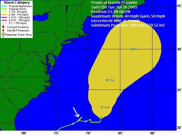
Franklin HAS already done a loop... kinda small but it's a loop :wink:


Image
0 likes   

Sanibel
Category 5
Category 5
Posts: 10375
Joined: Mon Aug 30, 2004 11:06 pm
Location: Offshore SW Florida

#235 Postby Sanibel » Tue Jul 26, 2005 11:42 am

Bumping, grinding, and sheared to death...
0 likes   

Sanibel
Category 5
Category 5
Posts: 10375
Joined: Mon Aug 30, 2004 11:06 pm
Location: Offshore SW Florida

#236 Postby Sanibel » Tue Jul 26, 2005 1:38 pm

Another stall and bump west...
0 likes   

User avatar
Hurricaneman
Category 5
Category 5
Posts: 7349
Age: 44
Joined: Tue Aug 31, 2004 3:24 pm
Location: central florida

#237 Postby Hurricaneman » Tue Jul 26, 2005 1:43 pm

I seriously dont know, but Im thinking its going to the open atlantic
0 likes   

tampastorm
Category 1
Category 1
Posts: 434
Joined: Thu Aug 12, 2004 9:22 pm
Location: TAMPA

#238 Postby tampastorm » Tue Jul 26, 2005 1:53 pm

wobbling Southwest for now, lol
0 likes   

User avatar
Hurricaneman
Category 5
Category 5
Posts: 7349
Age: 44
Joined: Tue Aug 31, 2004 3:24 pm
Location: central florida

#239 Postby Hurricaneman » Tue Jul 26, 2005 1:59 pm

Looks to be
0 likes   

Sanibel
Category 5
Category 5
Posts: 10375
Joined: Mon Aug 30, 2004 11:06 pm
Location: Offshore SW Florida

#240 Postby Sanibel » Tue Jul 26, 2005 1:59 pm

A westward circulating lobe has moved to the north of Franklin. The WV loop shows west-moving air to Franklin's north.

It is possible the trough coming from the US could combine with this and send Franklin more NW.

A nice pseudo-eye has developed in the sheared surface spiral...
0 likes   


Return to “Talkin' Tropics”

Who is online

Users browsing this forum: No registered users and 86 guests