AREA FORECAST DISCUSSION
NATIONAL WEATHER SERVICE SAN JUAN PR
411 PM AST THU JUL 28 2005
.DISCUSSION...
A TRICKY FORECAST FOR THE NEXT 48 HOURS. A DEVELOPING TROPICAL WAVE
NEAR 17 NORTH AND 56 WEST CONTINUES TO THE WEST NORTH WEST. BASED ON
ITS CURRENT MOTION AND THE FORECAST FROM THE LATEST GFS GUIDANCE
INDICATES THAT THE WAVE MAY BE NEAR 20 NORTH AND 65 WEST IN 48 HOURS
OR SLIGHTLY LESS. SOME CLOUDINESS AND MOISTURE AHEAD OF THE WAVE IS
CURRENTLY APPROACHING THE WINDWARD AND LEEWARD ISLANDS AND WILL
SLOWLY START TO APPROACH THE U.S. VIRGIN ISLANDS EARLY ON FRIDAY.
LATER ON FRIDAY AND INTO SATURDAY THE POTENTIAL FOR CONVECTION
SHOULD INCREASE ACROSS THE LOCAL ISLANDS AND LINGER INTO SUNDAY. THE
LATEST WATER VAPOR IMAGERY INDICATES A TUTT SEGMENT MOVING TO THE
SOUTHWEST AND IS FORECAST TO BE NEAR 25 NORTH AND 60 WEST ON FRIDAY
AND BASED ON CURRENT GUIDANCE IT MAY NOT BE IN A FAVORABLE POSITION
TO ENHANCE CONVECTION ON SATURDAY...BUT ITS PROGRESS WILL HAVE TO BE
WATCHED CLOSELY. AN ASSOCIATED WIND SURGE AHEAD OF THE WAVE IS
EXPECTED TO ENTER THE NORTHEAST CARIBBEAN TONIGHT INTO FRIDAY WITH A
SLOW STEADY INCREASE IN THE SEAS ACROSS THE OFFSHORE ATLANTIC AND
CARIBBEAN WATERS. THE MORNING QUICKSCAT PASS WAS IN AN EXCELLENT
POSITION TO CAPTURE THE APPARENT WIND SURGE.
For those fellow members who live in Puerto Rico,Culebra,Vieques,The US and BVI and the northern Leewards this is what NWS San Juan see things evolve for us in the next 24-36 hours.
Post conditions in PR,Culebra,Vieques,VI,St Marteen
Moderator: S2k Moderators
Forum rules

The posts in this forum are NOT official forecasts and should not be used as such. They are just the opinion of the poster and may or may not be backed by sound meteorological data. They are NOT endorsed by any professional institution or STORM2K. For official information, please refer to products from the National Hurricane Center and National Weather Service.
-
cycloneye

- Admin

- Posts: 148836
- Age: 69
- Joined: Thu Oct 10, 2002 10:54 am
- Location: San Juan, Puerto Rico
Post conditions in PR,Culebra,Vieques,VI,St Marteen
Last edited by cycloneye on Sat Jul 30, 2005 6:28 am, edited 4 times in total.
0 likes
Visit the Caribbean-Central America Weather Thread where you can find at first post web cams,radars
and observations from Caribbean basin members Click Here
and observations from Caribbean basin members Click Here


-
cycloneye
- Admin
- Posts: 148836
- Age: 69
- Joined: Thu Oct 10, 2002 10:54 am
- Location: San Juan, Puerto Rico
TheBurn wrote:When do you expect the swell to start building up, cycloneye?
First of all welcome to storm2k and enjoy it here.
About the seas here is the coastal forecast:
COASTAL WATERS FORECAST
NATIONAL WEATHER SERVICE SAN JUAN PR
430 PM AST THU JUL 28 2005
PUERTO RICO AND U.S. VIRGIN ISLANDS WATERS
AMZ700-290300-
SYNOPSIS FOR PUERTO RICO AND THE U.S. VIRGIN ISLANDS WATERS
430 PM AST THU JUL 28 2005
.SYNOPSIS...A SLOWLY DEVELOPING TROPICAL WAVE LOCATED NEAR 56 WEST
WILL CONTINUE ON A WEST NORTHWEST MOTION OVER THE NEXT TWENTY FOUR
HOURS. WEATHER ASSOCIATED WITH THIS TROPICAL WAVE WILL MOVE INTO THE
VIRGIN ISLANDS AND ADJACENT WATERS EARLY FRIDAY...AND THEN SPREAD
WEST AND NORTHWEST ACROSS THE REMAINDER OF THE REGION FRIDAY
AFTERNOON THROUGH SUNDAY. WIND AND SEAS ACROSS THE OFF SHORE
ATLANTIC ARE EXPECTED TO INCREASE WITH AND JUST AHEAD OF THE PASSAGE
OF THIS TROPICAL WAVE....
SMALL CRAFT EXERCISE CAUTION...
.TONIGHT...EAST NORTHEAST WINDS 13 TO 19 KNOTS. SEAS 3 TO 4 FEET.
HAZE THROUGH THE NIGHT. SCATTERED SHOWERS THROUGH THE NIGHT.
ISOLATED THUNDERSTORMS AFTER MIDNIGHT.
.FRIDAY...NORTHEAST WINDS 11 TO 18 KNOTS. SEAS 4 TO 5 FEET. HAZE IN
THE MORNING. SCATTERED SHOWERS AND ISOLATED THUNDERSTORMS THROUGH
THE DAY.
.FRIDAY NIGHT...EAST NORTHEAST WINDS 13 TO 19 KNOTS SHIFTING TO THE
EAST SOUTHEAST 8 TO 14 KNOTS AFTER MIDNIGHT. SEAS 5 TO 6 FEET.
SCATTERED SHOWERS AND ISOLATED THUNDERSTORMS.
.SATURDAY...SOUTH WINDS 7 TO 15 KNOTS. SEAS 5 FEET. NUMEROUS SHOWERS
AND ISOLATED THUNDERSTORMS.
.SATURDAY NIGHT...SOUTHEAST WINDS 8 TO 12 KNOTS. SEAS 5 FEET.
NUMEROUS SHOWERS AND ISOLATED THUNDERSTORMS
0 likes
-
cycloneye
- Admin
- Posts: 148836
- Age: 69
- Joined: Thu Oct 10, 2002 10:54 am
- Location: San Juan, Puerto Rico
TheBurn wrote:Thanks for the info as well as the welcome.
I've been lurking for a few days. You guys do an incredible job here!
Great stuff!
Thank you for those words.
0 likes
Visit the Caribbean-Central America Weather Thread where you can find at first post web cams,radars
and observations from Caribbean basin members Click Here
and observations from Caribbean basin members Click Here
-
cycloneye
- Admin
- Posts: 148836
- Age: 69
- Joined: Thu Oct 10, 2002 10:54 am
- Location: San Juan, Puerto Rico
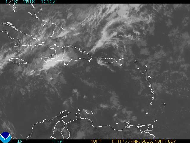
The original Low Level center is almost due east of Guadeloupe and Antigua moving westward in that area of convection more smaller than the more east convection area.
0 likes
Visit the Caribbean-Central America Weather Thread where you can find at first post web cams,radars
and observations from Caribbean basin members Click Here
and observations from Caribbean basin members Click Here
-
cycloneye
- Admin
- Posts: 148836
- Age: 69
- Joined: Thu Oct 10, 2002 10:54 am
- Location: San Juan, Puerto Rico
Janice wrote:Thanks so much, I will be watching it closely.
Yes let's see what happens in terms of the effects in the northern islands.
0 likes
Visit the Caribbean-Central America Weather Thread where you can find at first post web cams,radars
and observations from Caribbean basin members Click Here
and observations from Caribbean basin members Click Here


We had one big squall this afternoon - huge clap of thunder - heavy rain for a little while, then drizzle and then wet air through the haze. Now we're just getting gusts of wind but THANKFULLY it's cooled off a bit from sheer heatheatheat. Everyone here is hoping for SOME rain for a break from the high temps, but afraid to even say it very loudly, since we know what happens when we complain!
0 likes
-
bvigal

- S2K Supporter

- Posts: 2276
- Joined: Sun Jul 24, 2005 8:49 am
- Location: British Virgin Islands
- Contact:
From both satellite and radar, it looks like the showers we are seeing in the area (and a few thunderstorms) are pushing in here from the NE. The tropical water vapor loop shows this. And also shows the 1026mb high to our north, indicated on latest surface map
Anyway, I sure will watch 92L closely.
Thanks, Luis, for posting the local discussion!
[/url]
Anyway, I sure will watch 92L closely.
Thanks, Luis, for posting the local discussion!
[/url]
0 likes
-
cycloneye
- Admin
- Posts: 148836
- Age: 69
- Joined: Thu Oct 10, 2002 10:54 am
- Location: San Juan, Puerto Rico
It looks like the battle for a dominating center is being dominated by the low center more south than the convection more to the east.If that low center dominates then it will cause more squally weather in the northern islands so fellow members who are in those islands (Puerto Rico,Culebra,Vieques,US and BVI and the northern leewards) keep an eye on this system.
0 likes
Visit the Caribbean-Central America Weather Thread where you can find at first post web cams,radars
and observations from Caribbean basin members Click Here
and observations from Caribbean basin members Click Here
-
cycloneye
- Admin
- Posts: 148836
- Age: 69
- Joined: Thu Oct 10, 2002 10:54 am
- Location: San Juan, Puerto Rico
AREA FORECAST DISCUSSION
NATIONAL WEATHER SERVICE SAN JUAN PR
515 AM AST FRI JUL 29 2005
.DISCUSSION...
STRONG TROPICAL WAVE...WITH LLVL LOW CENTER NEAR 17.5N 61W AT 5
AM... MOVING W AROUND 15 MPH...AND WILL SPREAD ACTIVE WEATHER AND
POTENTIAL FOR HEAVY RAINFALL INTO THE LOCAL AREA THIS MORNING
THROUGH LATE THIS EVENING. GLOBAL MODELS CONTINUE TO SUGGEST BEST
MOISTURE AND LIFT ASSOCIATED WITH THIS WAVE WILL PASS JUST TO THE
NORTH OF THE LOCAL ISLANDS THIS AFTERNOON THROUGH THIS EVENING.
HOWEVER...LLVL LOW LOOKS TO HAVE BEEN MOVING DUE WEST PAST 24
HOURS...AND IS TRAILING A MID TO UPPER LEVEL LOW NOW MOVING W AND
PASSING JUST S OF P.R. ATTM. THIS FEATURE MAY HELP TO PULL THE WAVE
VORTEX A BIT MORE WEST THAN FORECAST...AND ACROSS THE VIRGIN ISLANDS
AND E AND NE SECTIONS OF P.R. LATER THIS EVENING. STRONG GUSTY NE
WINDS WILL OCCUR OUT AHEAD OF THE WAVE AND COULD PRODUCE WIND GUSTS
OF 30 TO 45 MPH ACROSS THE LOCAL AREA IN SQUALLS AND TSTORMS. THEN
WITH THE MAIN LOW OR WAVE VORTEX MOVING ACROSS THE ISLANDS THIS
EVENING AND THEN THE LOCAL ATLANTIC TONIGHT...WITH A S TO SE LLVL
FLOW BUILDING INTO THE AREA BEHIND THE WAVE. THIS WILL PULL TROPICAL
MOISTURE WITH IT FOR SCATTERED SHOWERS AND ISOLATED TSTORMS...BUT
MOISTURE WILL BE SHALLOW AND RAINFALL NOT EXPECTED NEAR AS INTENSE
AS POSSIBLE WITH AND AHEAD OF THE WAVE.
Hey fellow islanders this will passs over us so be prepared for heavy rains in squalls today and tommorow as the surface low is tracking more west than forecasted.
From now on let's post here what are your conditions where you are,Puerto Rico,Culebra,Vieques,US and BVI and ST Marteen.
0 likes
Visit the Caribbean-Central America Weather Thread where you can find at first post web cams,radars
and observations from Caribbean basin members Click Here
and observations from Caribbean basin members Click Here
-
cycloneye
- Admin
- Posts: 148836
- Age: 69
- Joined: Thu Oct 10, 2002 10:54 am
- Location: San Juan, Puerto Rico
In Puerto Rico things are tranquil this morning with fair skies with a brezze from the NE.This is the sinking air in front of the low developing.But the weather will go downhill later today here.
COASTAL WATERS FORECAST
NATIONAL WEATHER SERVICE SAN JUAN PR
430 AM AST FRI JUL 29 2005
PUERTO RICO AND U.S. VIRGIN ISLANDS WATERS
AMZ700-291500-
SYNOPSIS FOR PUERTO RICO AND THE U.S. VIRGIN ISLANDS WATERS
430 AM AST FRI JUL 29 2005
.SYNOPSIS...A STRONG TROPICAL WAVE WAS MOVING INTO THE LEEWARD
ISLANDS EARLY THIS MORNING...AND WAS ALIGNED NORTHEAST TO
SOUTHWEST...MOVING WESTWARD AT 15 MPH. A NORTHEAST WIND SURGE
ACCOMPANIED BY NUMEROUS SHOWERS AND SQUALLS WILL SPREAD FROM THE
ATLANTIC WATERS NORTH OF THE LEEWARD ISLANDS THIS MORNING...WESTWARD
INTO THE LOCAL OFF SHORE ATLANTIC TODAY THROUGH THIS EVENING. AN
ASSOCIATED SURFACE LOW PRESSURE CONTINUES TO ATTEMPT TO BETTER
ORGANIZE THIS MORNING...AND WAS LOCATED NEAR 17.5 NORTH 61 WEST.
THIS LOW ACCOMPANIED BY SCATTERED INTENSE THUNDERSTORMS WILL MOVE
WEST NORTHWEST ACROSS THE ANEGADA PASSAGE TODAY AND THEN CROSS THE
VIRGIN ISLANDS AND LOCAL ATLANTIC THIS EVENING AND TONIGHT. A SOUTH
TO SOUTHEAST WIND FLOW BEHIND THE EXITING TROPICAL WAVE WILL PREVAIL
SATURDAY AND SUNDAY BEFORE EASTERLY TRADE WINDS RETURN TO THE REGION
FOR THE BEGINNING OF THE WEEK.
Above is the coastal waters forecast.
0 likes
Visit the Caribbean-Central America Weather Thread where you can find at first post web cams,radars
and observations from Caribbean basin members Click Here
and observations from Caribbean basin members Click Here
-
schmita
- Tropical Storm

- Posts: 205
- Joined: Fri May 21, 2004 4:35 pm
- Location: Sint Maarten/ 18.05 N 63.12 W
Good Morning
Hi all,
Here in Sint Maarten this morning we are having partly cloudy skies, a bit of haze.
Rain gauge reports about 1/2 inch overnight.
Let's see what the day brings.
irina
Here in Sint Maarten this morning we are having partly cloudy skies, a bit of haze.
Rain gauge reports about 1/2 inch overnight.
Let's see what the day brings.
irina
0 likes
-
mf_dolphin

- Category 5

- Posts: 17758
- Age: 69
- Joined: Tue Oct 08, 2002 2:05 pm
- Location: St Petersburg, FL
- Contact:
-
mf_dolphin
- Category 5
- Posts: 17758
- Age: 69
- Joined: Tue Oct 08, 2002 2:05 pm
- Location: St Petersburg, FL
- Contact:
Who is online
Users browsing this forum: No registered users and 100 guests