Official 93L Invest thread=93L is not anymore at NRL
Moderator: S2k Moderators
Forum rules

The posts in this forum are NOT official forecasts and should not be used as such. They are just the opinion of the poster and may or may not be backed by sound meteorological data. They are NOT endorsed by any professional institution or STORM2K. For official information, please refer to products from the National Hurricane Center and National Weather Service.
-
Astro_man92

- Category 5

- Posts: 1493
- Joined: Sun Jul 17, 2005 1:26 am
- Contact:
-
cycloneye

- Admin

- Posts: 148837
- Age: 69
- Joined: Thu Oct 10, 2002 10:54 am
- Location: San Juan, Puerto Rico
cycloneye wrote:
Thanks dixie.


0 likes
Visit the Caribbean-Central America Weather Thread where you can find at first post web cams,radars
and observations from Caribbean basin members Click Here
and observations from Caribbean basin members Click Here
17Z obs
Grenada
TGPY 311700Z 27007KT 9999 -RA SCT014 SCT038 BKN260 26/24 Q1013
Altimeter dropped a millibar ... special advisory!
Tobago
St Vincent
TVSV 311700Z 08010KT 9999 -TSRA BKN010 SCT012CB BKN03227/25 Q1014, CB ALL QUADS=
St Lucia
TLPL 311700Z 08023KT 8000 TSRA FEW009 BKN015CB BKN080 25/22 Q1014=
Martinique
TFFF 311700Z 08006KT 050V130 9000 -RA SCT013 SCT020 OVC100 26/24Q1015 TEMPO
5000 SHRA=
METAR... not as good as recon but when you have a nasty fever it helps...
Since it was mentioned below, here's the last few hours from Barbados
TBPB 311100Z 09003KT 9999 FEW012CB SCT035 BKN100 27/25 Q1013 RERA/DIST CB NW/N AND W=
TBPB 311200Z 12010KT 9999 SCT012CB SCT035 28/25 Q1014 RMK CBE TRU S,JP-S=
TBPB 311300Z 11009KT 5000 -SHRA SCT010CB SCT014 27/25 Q1014 RMK CB E-SE=
TBPB 311330Z 11014KT 1500 SHRA SCT010CB BKN012 27/24 Q1014 RMK CB E-S=
TBPB 311400Z 10015KT 9999 FEW010CB SCT035 BKN100 26/25 Q1014 RMK CB SE,SW=
TBPB 311500Z 03004KT 9999 SCT010CB SCT035 BKN100 25/24 Q1014=
TBPB 311600Z 36005KT 9999 -RA SCT010CB SCT035 BKN100 25/24 Q1014=
TBPB 311610Z 35007KT -TSRA SCT010CB SCT035 BKN100 25/24 Q1014 RMK CB ALL QUADS=
TBPB 311637Z 03005KT 9999 -RA SCT010CB SCT035 BKN100 26/24 Q1014=
TBPB 311700Z 02005KT 9999 SCT010CB SCT035 BKN100 26/24 Q1014=
Last edited by clfenwi on Sun Jul 31, 2005 12:40 pm, edited 1 time in total.
0 likes

-
Matt-hurricanewatcher
-
Matt-hurricanewatcher
You can see a cirualtion. It is elongated from southwest to northeast. http://www.cira.colostate.edu/ramm/rmsd ... PICAL.html
0 likes
-
stormchazer

- Category 5
- Posts: 2462
- Joined: Fri Aug 29, 2003 12:00 pm
- Location: Lakeland, Florida
- Contact:
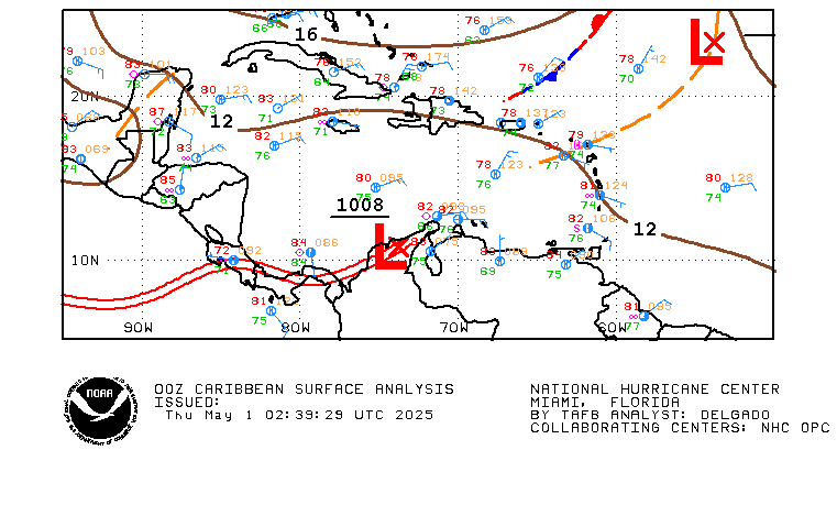
Astro_man92 wrote:that is a crude weather map the clouds are drawn in
Straight from the NHC...
http://www.nhc.noaa.gov/tafb/CAR_00Z.gif
Its their crude map. I guess they are not a good source.
0 likes


000
WHXX01 KWBC 312025
CHGHUR
DISCLAIMER...NUMERICAL MODELS ARE SUBJECT TO LARGE ERRORS.
PLEASE REFER TO TPC/NHC OFFICIAL FORECASTS FOR TROPICAL CYCLONES.
.....THE FOLLOWING IS A TEST MESSAGE.....
NATIONAL HURRICANE CENTER NORTH ATLANTIC OBJECTIVE AIDS FOR
TROPICAL DEPRESSION INVEST (AL932005) ON 20050731 1800 UTC
...00 HRS... ...12 HRS... ...24 HRS... ...36 HRS...
050731 1800 050801 0600 050801 1800 050802 0600
LAT LON LAT LON LAT LON LAT LON
BAMD 12.5N 61.5W 13.1N 64.4W 14.0N 67.1W 15.1N 69.7W
BAMM 12.5N 61.5W 13.0N 64.4W 13.9N 67.1W 14.8N 69.5W
A98E 12.5N 61.5W 13.1N 65.0W 13.6N 68.2W 14.3N 71.1W
LBAR 12.5N 61.5W 13.1N 64.8W 14.0N 68.1W 15.0N 71.3W
SHIP 25KTS 31KTS 40KTS 48KTS
DSHP 25KTS 31KTS 40KTS 48KTS
...48 HRS... ...72 HRS... ...96 HRS... ..120 HRS...
050802 1800 050803 1800 050804 1800 050805 1800
LAT LON LAT LON LAT LON LAT LON
BAMD 16.0N 72.0W 17.5N 76.3W 19.0N 79.9W 20.3N 83.0W
BAMM 15.6N 71.9W 16.6N 76.8W 17.6N 81.6W 18.2N 86.5W
A98E 14.8N 73.7W 16.6N 78.0W 18.3N 81.9W 19.9N 85.6W
LBAR 15.8N 74.2W 17.2N 79.1W 19.9N 82.3W 23.0N 84.2W
SHIP 58KTS 72KTS 81KTS 85KTS
DSHP 58KTS 72KTS 81KTS 85KTS
...INITIAL CONDITIONS...
LATCUR = 12.5N LONCUR = 61.5W DIRCUR = 280DEG SPDCUR = 18KT
LATM12 = 11.9N LONM12 = 57.9W DIRM12 = 281DEG SPDM12 = 18KT
LATM24 = 11.1N LONM24 = 54.0W
WNDCUR = 25KT RMAXWD = 35NM WNDM12 = 25KT
CENPRS = 1011MB OUTPRS = 1013MB OUTRAD = 120NM SDEPTH = M
RD34NE = 0NM RD34SE = 0NM RD34SW = 0NM RD34NW = 0NM
.....THE ABOVE HAS BEEN A TEST MESSAGE.....
0 likes

18-20Z surface obs
Barbados
TBPB 311800Z 03008KT 9999 FEW010CB BKN100 27/25 Q1013=
TBPB 311900Z 04010KT 9999 FEW010CB BKN100 27/25 Q1012=
TBPB 312000Z 04009KT 9999 FEW010CB SCT100 BKN300 28/25Q1011=
Tobago
TTCP 311800Z 32005KT 8000 VCSH FEW010CB SCT012 BKN035 28/24 Q1013 TEMPO TSRA=
TTCP 311900Z 03004KT 5000 VCSH FEW008CB SCT012 SCT035 28/23 Q1013 TEMPO SHRA=
TTCP 312000Z 00000KT 9999 SCT012 SCT035 BKN100 26/24 Q1012 NSW=
Grenada
TBPB 311800Z 03008KT 9999 FEW010CB BKN100 27/25 Q1013=
TBPB 311900Z 04010KT 9999 FEW010CB BKN100 27/25 Q1012=
TBPB 312000Z 04009KT 9999 FEW010CB SCT100 BKN300 28/25Q1011=
St Vincent
TVSV 311900Z 0910KT 99 -RA FEW008 SCT032 OVC070 25/23 Q1011=
TVSV 312000Z 08010KT 9999 BKN010 SCT032 OVC070 26/24 Q1011=
St Lucia
TLPL 311800Z 04011KT 9999 -RA FEW009 SCT015CB OVC080 25/24 Q1013=
TLPL 311900Z 08016KT 9999 -RA FEW015CB SCT017 BKN080 25/23 Q1011=
Martinique
TFFF 311800Z 11003KT 9999 FEW013CB SCT020 BKN090 27/24 Q1013 TEMPO 40 0 0 TSRA=
TFFF 311900Z 09005KT 070V140 9999 FEW020 BKN100 27/24 Q1012 TEMPO5000 SHRA=
0 likes
-
elysium
While the season has slowed down a little; I think that this is now the second or possibly third straight day we have had now without a named storm to track; 93L and a strong wave exiting the african coast, along with a strong wave getting ready to roll off the african coast, promises to quicken the tropical pace somewhat over the next 5 to 10 days. It is not clear whether we will see the heavier type activity that we had throughout the first half of july, however if 93L can make it into the GOM, there would be ample opportunity for it to develop further.
The high pressure ridge is forecast to retreat and this would allow for GOM entry sometime late next week with the outside possibility of additional tropical activity approaching the windward islands in this same time slot. Depending on how far back the ridge pulls over the next several days, Florida may have to keep a close eye on 93L. Haven't done my homework on 93l yet so estimates on intensity would be little more than guesses at this point in time. The GOM sst's aren't unsupportive for continued development and 93L may get interesting next week.
The high pressure ridge is forecast to retreat and this would allow for GOM entry sometime late next week with the outside possibility of additional tropical activity approaching the windward islands in this same time slot. Depending on how far back the ridge pulls over the next several days, Florida may have to keep a close eye on 93L. Haven't done my homework on 93l yet so estimates on intensity would be little more than guesses at this point in time. The GOM sst's aren't unsupportive for continued development and 93L may get interesting next week.
0 likes
-
WeatherEmperor
- S2K Supporter

- Posts: 4806
- Age: 41
- Joined: Thu Sep 04, 2003 2:54 pm
- Location: South Florida
ABNT20 KNHC 312115
TWOAT
TROPICAL WEATHER OUTLOOK
NWS TPC/NATIONAL HURRICANE CENTER MIAMI FL
530 PM EDT SUN JUL 31 2005
FOR THE NORTH ATLANTIC...CARIBBEAN SEA AND THE GULF OF MEXICO...
A VIGOROUS TROPICAL WAVE...ACCOMPANIED BY A BROAD SURFACE LOW
PRESSURE AREA...IS MOVING THROUGH THE SOUTHERN LESSER ANTILLES.
SURFACE PRESSURES ARE SLOWLY FALLING AND THIS SYSTEM HAS BECOME A
LITTLE BETTER ORGANIZED TODAY...EVEN THOUGH THUNDERSTORM ACTIVITY
IS CURRENTLY LIMITED. UPPER-LEVEL WINDS HAVE ALSO BECOME MORE
FAVORABLE FOR SOME SLOW DEVELOPMENT TO OCCUR OVER THE NEXT COUPLE
OF DAYS...AND AN AIR FORCE RESERVE UNIT RECONNAISSANCE AIRCRAFT IS
SCHEDULED TO INVESTIGATE THE SYSTEM TOMORROW...IF NECESSARY. BRIEF
PERIODS OF HEAVY RAINFALL AND GUSTY WINDS OF 30 TO 35 MPH IN
SQUALLS WILL BE POSSIBLE AS THE SYSTEM MOVES WESTWARD AT 10 TO 15
MPH.
0 likes
-
Hurricanehink

- S2K Supporter
- Posts: 2047
- Joined: Sun Nov 16, 2003 2:05 pm
- Location: New Jersey
Looks like it has potential.
Last edited by Hurricanehink on Sun Jul 31, 2005 4:46 pm, edited 1 time in total.
0 likes
-
deltadog03

- Professional-Met

- Posts: 3580
- Joined: Tue Jul 05, 2005 6:16 pm
- Location: Macon, GA
Not sure if the actual sfc center is as far west as NHC had it for the 18Z run; I think they're using the mid-level center.
There is indeed a weak surface circ (the rapid motion west means the west winds to the S of the center are quite light) but I think it's lagging behind the mid-level center (which has that blob of convection.); something that's common with these fast-moving waves. Fast motion per se has absolutely nothing to do with something not developing - what happens is you have easterly surface winds and faster easterly winds at mid-level, so there's a TAD of easterly shear meaning the sfc and mid-level centers are a bit misaligned.
Overall the upper level winds seem great for development, and looks like they will remain so for at least a couple of days. Was a bit befuddled at the over-confident assurances of some that it would be badly sheared in the Carribean.
0 likes
-
Matt-hurricanewatcher
-
Derek Ortt
Who is online
Users browsing this forum: gib and 104 guests