MJO

This is the general tropical discussion area. Anyone can take their shot at predicting a storms path.

Moderator: S2k Moderators

Forum rules

The posts in this forum are NOT official forecasts and should not be used as such. They are just the opinion of the poster and may or may not be backed by sound meteorological data. They are NOT endorsed by any professional institution or STORM2K. For official information, please refer to products from the National Hurricane Center and National Weather Service.

Help Support Storm2K
Message
Author
User avatar
EDR1222
S2K Supporter
S2K Supporter
Posts: 1253
Joined: Mon Nov 10, 2003 12:58 pm
Location: Melbourne, FL

#61 Postby EDR1222 » Tue Aug 02, 2005 6:37 am

Derek Ortt wrote:I would be surprised if we revert back to favorable by mid August.

I heard soemthing yesterday at the daily HRD briefing regarding the MJO. They were speculating that it was real active in July because it was negative at the date line. That descending air there led to la nina-like conditions in the Atl, but now it is positive, which leads to el ninoish. And this last phase did not exactly set any speed records in changing.
We may be in the unfavorable phase until the end of the month or early next if this is the case. Still could get a couple of storms during this time, so everyone does need to keep watch as it only takes one


That would put the clamps on the season at least for a while.
Interesting.
0 likes   

Jim Hughes
Category 3
Category 3
Posts: 825
Joined: Sun Jul 24, 2005 1:52 pm
Location: Martinsburg West Virginia

#62 Postby Jim Hughes » Tue Aug 02, 2005 6:40 am

Derek Ortt wrote:I would be surprised if we revert back to favorable by mid August.

I heard soemthing yesterday at the daily HRD briefing regarding the MJO. They were speculating that it was real active in July because it was negative at the date line. That descending air there led to la nina-like conditions in the Atl, but now it is positive, which leads to el ninoish. And this last phase did not exactly set any speed records in changing.
We may be in the unfavorable phase until the end of the month or early next if this is the case. Still could get a couple of storms during this time, so everyone does need to keep watch as it only takes one


Well the atmosphere was changing last month. We saw a considerable move in the 90 day SOI average. It never went into positive territory but this was the closest it had gotten to it since last November. The SOI pattern has changed the past week just like the MJO.
0 likes   

User avatar
boca
Category 5
Category 5
Posts: 6365
Age: 60
Joined: Mon Dec 15, 2003 8:49 am
Location: Boca Raton,FL

#63 Postby boca » Tue Aug 02, 2005 7:12 am

I know we had 7 storms to date,but an average season is 10.Will we now probably have a little above average now or will the season be like June and July.
0 likes   

Frank2
Category 5
Category 5
Posts: 4061
Joined: Mon Jul 25, 2005 12:47 pm

#64 Postby Frank2 » Tue Aug 02, 2005 9:35 am

Re: Derek Ott's post (8/1/05)

I agree totally, but many in the media continue pouncing on the fact that "this is a record season". As you said, the total number of named systems is of little consequence, with the current season so far only being slightly above average, though as you mentioned, the concern is with the two Cat 4 systems, and is understandable.

One thing that stands out in my mind at this time are the three main factors against development - the current negative MJO, the current SAL pattern (we are now having our share of milky skies and supressed convection here in South Florida), and a continued weak subtropical high in the western Atlantic.

As I was told more than once at the HRD concerning any hurricane season - it can be compared to a recipe - if just one ingredient is missing, then the outcome will not be as expected.

It only makes sense that one or more than one of these factors might make a significant difference in the upcoming 6-8 weeks - we'll see what happens.

Frank
0 likes   

User avatar
cycloneye
Admin
Admin
Posts: 143865
Age: 68
Joined: Thu Oct 10, 2002 10:54 am
Location: San Juan, Puerto Rico

#65 Postby cycloneye » Tue Aug 02, 2005 10:29 am

Image

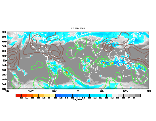
Update for august 2 about progress of MJO.

Interesting that the brown lines haved moved almost out of the Atlantic Basin except the eastern atlantic.This means that the dry phase of MJO is going away from the atlantic more faster than predicted and that may allow for the positive phase to get in more sooner meaning more favorable conditions a little earlier than expected.
0 likes   
Visit the Caribbean-Central America Weather Thread where you can find at first post web cams,radars
and observations from Caribbean basin members Click Here

User avatar
TS Zack
Category 4
Category 4
Posts: 925
Joined: Thu Jul 01, 2004 6:23 pm
Location: Louisiana
Contact:

#66 Postby TS Zack » Tue Aug 02, 2005 10:30 am

Another perspective..

<img src="http://www.cpc.ncep.noaa.gov/products/precip/CWlink/MJO/gfs.gif">
0 likes   

Derek Ortt

#67 Postby Derek Ortt » Tue Aug 02, 2005 10:32 am

but its still producing serious upward motion at the dateline. This pushes the Walker Circulation farther east, producing shear over the Atl basin
0 likes   

Frank2
Category 5
Category 5
Posts: 4061
Joined: Mon Jul 25, 2005 12:47 pm

#68 Postby Frank2 » Tue Aug 02, 2005 11:09 am

Re: Astro_man92's post

It might be boring in Michigan (though I wouldn't want to be there for lake-effect snow), but here in hurricane vulnerable South Florida we are grateful for the extended break!

Take care,

Frank
0 likes   

User avatar
AJC3
Admin
Admin
Posts: 3998
Age: 61
Joined: Tue Aug 31, 2004 7:04 pm
Location: West Melbourne, Florida
Contact:

#69 Postby AJC3 » Tue Aug 02, 2005 11:17 am

Frank2 wrote:Re: Derek Ott's post (8/1/05)

I agree totally, but many in the media continue pouncing on the fact that "this is a record season". As you said, the total number of named systems is of little consequence, with the current season so far only being slightly above average. <snip> Frank


With respect to Net Tropical Cyclone (NTC) activity, descibing this season as *only slightly above average* is about as far from being accurate as possible.

And to say, "well if you don't count the two cat four's..." is a disingenuous arguement - tantamount to saying, "well if you don't count the fact that the A's are the hottest team in MLB since the All-Star break, they're having a mediocre season.

Average seasonal ATLC basin NTC activity by the end of July is somewhere between 6 and 7 percent - so far this season the Atlantic basin has recorded over 60 percent of it's normal seasonal NTC. I don't think you'll see anyone in the field argue that there was "slightly above average" about the unprecedented Atlantic basin activity of June-July of 2005. Sure, Dennis and Emily account for the lion's share of the numbers...but heck, no discussion of the "bad" season to date can legitimately not take them into account.

MHO
Tony
0 likes   

rockyman
Category 5
Category 5
Posts: 1967
Joined: Thu Jun 26, 2003 12:24 pm
Location: Dauphin Island, AL

#70 Postby rockyman » Tue Aug 02, 2005 11:24 am

Image

Image

Dry phase is moving out fast
0 likes   

Frank2
Category 5
Category 5
Posts: 4061
Joined: Mon Jul 25, 2005 12:47 pm

#71 Postby Frank2 » Tue Aug 02, 2005 2:49 pm

Re: AJC3's post

I understand, but, it's similar to a half-full or half-empty situation - if the season has 20 named systems, but, 16 are tropical storms, then, while the season had a high number of named systems, the season's overall activity was actually within it's normal limits, as far as hurricanes are concerned.

As you know, we now have a new tropical depression, but, if this becomes and remains a tropical storm (Harvey), then, we'll have 8 named systems, with only 2 intensifying to hurricane status - so far.

Frank
0 likes   

User avatar
wxwatcher91
Category 5
Category 5
Posts: 1606
Joined: Wed Jul 06, 2005 2:43 pm
Location: Keene, NH
Contact:

#72 Postby wxwatcher91 » Tue Aug 02, 2005 3:00 pm

Frank2 wrote:Re: AJC3's post

I understand, but, it's similar to a half-full or half-empty situation - if the season has 20 named systems, but, 16 are tropical storms, then, while the season had a high number of named systems, the season's overall activity was actually within it's normal limits, as far as hurricanes are concerned.

As you know, we now have a new tropical depression, but, if this becomes and remains a tropical storm (Harvey), then, we'll have 8 named systems, with only 2 intensifying to hurricane status - so far.

Frank


you are forgetting the fact that so far this season THREE tropical storms have come within 4mph of hurricane status and at least one of which there is much contraversy if it actually MADE hurricane status
DONT discount Arlene, Cindy, and Franklin
0 likes   

Frank2
Category 5
Category 5
Posts: 4061
Joined: Mon Jul 25, 2005 12:47 pm

#73 Postby Frank2 » Tue Aug 02, 2005 3:22 pm

True, but, as Steve Lyons has mentioned more than once, there is much difference between a 70 mph tropical storm and a 150 mph hurricane - similar to the difference between a 4.0 tremor and a 9.0 great earthquake, since the difference between both a weak and strong hurricane (or earthquake) is exponential.

Frank
0 likes   

floridahurricaneguy
Category 1
Category 1
Posts: 312
Joined: Tue Jul 19, 2005 10:37 pm
Location: Tampa,FL
Contact:

#74 Postby floridahurricaneguy » Tue Aug 02, 2005 3:24 pm

So frank are you think the season will end up not being real active? Anyone else agree?

Matt
0 likes   

Frank2
Category 5
Category 5
Posts: 4061
Joined: Mon Jul 25, 2005 12:47 pm

#75 Postby Frank2 » Tue Aug 02, 2005 3:26 pm

Since TD8 has just formed (as of 5 p.m. ET), I'd be foolish to say yes, but, I do believe the overall pattern to be different from last season.

I'm not saying it won't be active (it already has as noted), but, I do believe the season won't follow the same pattern, track-wise (it seems to be true so far to some extent, since TD8 is following a track similar to Franklin) - while all are similar in some way, each season is different from the last.

Frank
Last edited by Frank2 on Tue Aug 02, 2005 3:30 pm, edited 1 time in total.
0 likes   

User avatar
wxwatcher91
Category 5
Category 5
Posts: 1606
Joined: Wed Jul 06, 2005 2:43 pm
Location: Keene, NH
Contact:

#76 Postby wxwatcher91 » Tue Aug 02, 2005 3:29 pm

sorry but I'm still calling for 20+ storms
0 likes   

User avatar
EDR1222
S2K Supporter
S2K Supporter
Posts: 1253
Joined: Mon Nov 10, 2003 12:58 pm
Location: Melbourne, FL

#77 Postby EDR1222 » Tue Aug 02, 2005 5:32 pm

Looks like the ridge is still fairly weak. It will be interesting to see if that pattern begins to change again as we get further into August.
0 likes   

WeatherEmperor
S2K Supporter
S2K Supporter
Posts: 4806
Age: 41
Joined: Thu Sep 04, 2003 2:54 pm
Location: South Florida

#78 Postby WeatherEmperor » Tue Aug 02, 2005 5:44 pm

EDR1222 wrote:Looks like the ridge is still fairly weak. It will be interesting to see if that pattern begins to change again as we get further into August.


what do you mean the ridge is weak? Can you tell me how to look at that feature on graphics?

<RICKY>
0 likes   

Frank2
Category 5
Category 5
Posts: 4061
Joined: Mon Jul 25, 2005 12:47 pm

#79 Postby Frank2 » Wed Aug 03, 2005 9:58 am

Yes, the ridge has been weak or absent west of 50W for the past two or three weeks (since Emily).

The troughs that these slow-moving tropical storms can leave behind (both Franklin and Harvey have lingered in same area for many days, both during development and during Franklin's life cycle) can often significantly change a weather pattern, since they continue to erode or totally break down the high pressure that was once there - we'll see if the ridge builds again, but, I'll guess and say that if we have a third disturbance linger and form in the same area as Franklin and Harvey, that will be a sure sign that the pattern is a long-term one, and would favor more recurving systems.

Frank
0 likes   

User avatar
cycloneye
Admin
Admin
Posts: 143865
Age: 68
Joined: Thu Oct 10, 2002 10:54 am
Location: San Juan, Puerto Rico

#80 Postby cycloneye » Wed Aug 03, 2005 10:03 am

Image

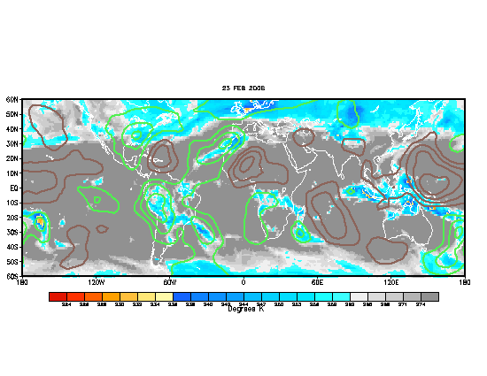
Update of MJO:

Wow now the green lines haved penetrated the atlantic.However returning to a very favorable status will take time and it wont be after mid august when things will really be more favorable for tropical cyclone formation.
0 likes   
Visit the Caribbean-Central America Weather Thread where you can find at first post web cams,radars
and observations from Caribbean basin members Click Here


Return to “Talkin' Tropics”

Who is online

Users browsing this forum: No registered users and 956 guests