http://manati.orbit.nesdis.noaa.gov/dat ... MBas99.png
this should be killed off at 11 a.m. as there is only a trough axis, with dissipating convection
QUIKSCAT says wide open wave
Moderator: S2k Moderators
Forum rules

The posts in this forum are NOT official forecasts and should not be used as such. They are just the opinion of the poster and may or may not be backed by sound meteorological data. They are NOT endorsed by any professional institution or STORM2K. For official information, please refer to products from the National Hurricane Center and National Weather Service.


-
Derek Ortt
the QS has some tyoe of circ at 16N, making me question it somewhat. However, based upon visible imagery, this is quite possible no longer a cyclone this morning and conditions may not become favorable for a while. I'll wait until I or Cangialosi look at more data before making any final conclusions
0 likes
-
Hyperstorm

- Category 5

- Posts: 1500
- Joined: Sun Sep 07, 2003 3:48 am
- Location: Ocala, FL
I mentioned this yesterday as it was evident that it was beginning to deteriorate. Each passing day the LLC has become smaller and tighter, so it was predictable what might be happening now. The system never re-developed a new LLC, which could have kept it going longer.
I'm still not sure if the center is there or not, as it looks like convection has covered it. But, looking at the low-level clouds on the south side, they are not moving to the east as well as before, indicating a spin down. I will wait a few more hours to confirm this. I think the NHC will wait until 5pm at the earliest to dissipate Irene, IF the LLC has fizzled.
I'm still not sure if the center is there or not, as it looks like convection has covered it. But, looking at the low-level clouds on the south side, they are not moving to the east as well as before, indicating a spin down. I will wait a few more hours to confirm this. I think the NHC will wait until 5pm at the earliest to dissipate Irene, IF the LLC has fizzled.
0 likes
Irene
Something is going on.
http://www.ssd.noaa.gov/PS/TROP/DATA/RT ... S85/20.jpg
How accurate are these 85 gig pics and loops at distinguishing the real LLC?
If it is the black, then I can indeed see it unwinding, slowing down and relocating. And all that dry air from the wv loops.
But there is some definite inflow and swirl on the IR and even some outflow.
Who knows?
0 likes
-
weatherwindow

- Category 4

- Posts: 904
- Joined: Mon Sep 20, 2004 9:48 am
- Location: key west/ft lauderdale
assuming the tpc has access to the same pass, why no mention in the 500am adv and discussion?....none of the telltale language..."disorganized", "difficulty locating center" etc normally a prelude to "opening" a circulation. i would have expected some hint of this in the 500am products..was this pass available prior to that time?....rich
0 likes
-
Derek Ortt
-
Hyperstorm
- Category 5
- Posts: 1500
- Joined: Sun Sep 07, 2003 3:48 am
- Location: Ocala, FL
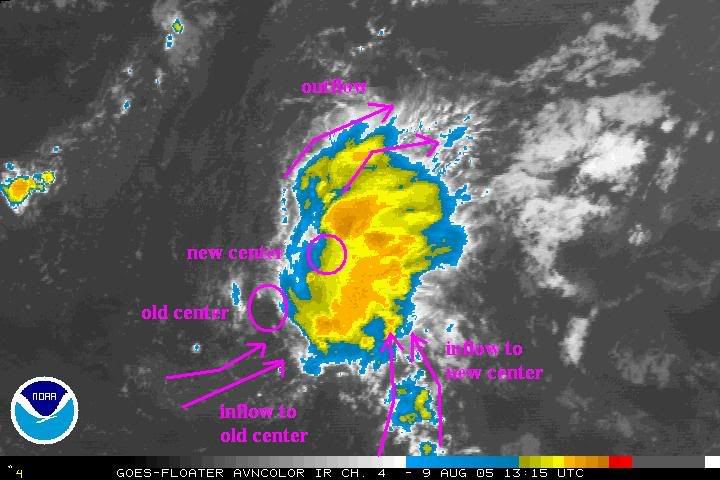
Analyzing the latest satellite images it appears that we're seeing the developments of a MLC right under the weakening convection. Here's an image I made depicting this:

The red circle indicates where the MLC is probably going to develop. The yellow lines on the SE and SW indicate where the inflow is coming from. The inflow to the SW is relating to the old center which appears to be becoming diffused. What's surprising is that there's inflow coming in from the SE to the East of where the center we're tracking is. This indicates that we're seeing some structural changes in the storm. Also, notice there's outflow developing to the NW of the storm, which is something we hadn't seen before with Irene.
Today will be a key day to the development of Irene. That being said, all factors are there for this MLC to gradually develop and spin down to the surface, giving new life to this tenacious cyclone.
I'll be watching this very interesting situation...
0 likes


-
swimaster20

- Category 1

- Posts: 285
- Joined: Tue Nov 23, 2004 2:41 pm
- Location: The Heart of Cajun Country
-
wxwatcher91

- Category 5
- Posts: 1606
- Joined: Wed Jul 06, 2005 2:43 pm
- Location: Keene, NH
- Contact:
-
txwatcher91
- Category 5
- Posts: 1498
- Joined: Tue Aug 02, 2005 2:29 pm
-
Hyperstorm
- Category 5
- Posts: 1500
- Joined: Sun Sep 07, 2003 3:48 am
- Location: Ocala, FL
wxwatcher91 wrote:so would this actually be a sign of organization considering the center is now reforming closer to the convection?
here is what I kinda see happening. comments wanted because I have little confidence I drew this right
Yes, I'm growing more confident that we'll see a MLC develop by later this afternoon. In fact, there are signs of high-level turning going on in the convection right now. The circle you have for a new center formation is likely too far north and too tight. It will likely be farther south and more broad similar to what I circled above.
This is very interesting as these are signs that there could be more intensification than currently forecasted...
0 likes
-
wxwatcher91
- Category 5
- Posts: 1606
- Joined: Wed Jul 06, 2005 2:43 pm
- Location: Keene, NH
- Contact:

-
Hurricanehink

- S2K Supporter

- Posts: 2047
- Joined: Sun Nov 16, 2003 2:05 pm
- Location: New Jersey
Who is online
Users browsing this forum: No registered users and 88 guests