East Atl/African Waves,Sat Pics,Models Discussion Thread

This is the general tropical discussion area. Anyone can take their shot at predicting a storms path.

Moderator: S2k Moderators

Forum rules

The posts in this forum are NOT official forecasts and should not be used as such. They are just the opinion of the poster and may or may not be backed by sound meteorological data. They are NOT endorsed by any professional institution or STORM2K. For official information, please refer to products from the National Hurricane Center and National Weather Service.

Help Support Storm2K
Message
Author
User avatar
cycloneye
Admin
Admin
Posts: 148499
Age: 69
Joined: Thu Oct 10, 2002 10:54 am
Location: San Juan, Puerto Rico

East Atl/African Waves,Sat Pics,Models Discussion Thread

#1 Postby cycloneye » Thu Aug 11, 2005 7:14 pm

TROPICAL WAVE LOCATED ABOUT 100 NM W OF THE AFRICAN COAST ALONG
18W/19W S OF 19N MOVING W 5-10 KT. A 1008 MB LOW IS LOCATED
ALONG THE WAVE ABOUT 70 NM NW OF DAKAR NEAR 15N18.5W BASED ON
WIND AND PRES OBSERVATIONS FROM NEARBY SHIPS AND LAND STATIONS.
THE WAVE IS DEVELOPING A WELL-DEFINED SIGNATURE WITH MID-LEVEL
CLOUDINESS BEGINNING TO "SPILL OVER" THE WAVE AXIS FROM THE
E...AND CONVECTION BEING ORIENTED ALONG A LINE FROM S OF THE
CAPE VERDES NEWD INTO W/CNTRL MAURITANIA. SCATTERED
MODERATE/STRONG INLAND OVER WRN MAURITANIA AND SENEGAL FROM
13N-22N BETWEEN 11W-17W. OTHER DEEP CONVECTION IS FARTHER W
ALONG THE ITCZ. SHOWERS/TSTMS ARE EXPECTED TO MOVE OVER THE CAPE
VERDE ISLANDS ON FRI AND SAT AS THE WAVE PASSES BY.


The above from the 8 PM Discussion:

A well defined wave has moved out of West Africa however the low pressure is way north in latitud 15n meaning if it develops :fishing:

I remember that Member Hyperstorm nailed this low pressure position days ago in his discussion up around 15n.
:darrow: :darrow: :darrow: :darrow:

SAT imagery
Last edited by cycloneye on Sun Aug 21, 2005 9:41 pm, edited 12 times in total.
0 likes   

User avatar
WindRunner
Category 5
Category 5
Posts: 5806
Age: 34
Joined: Fri Jul 29, 2005 8:07 pm
Location: Warrenton, VA, but Albany, NY for school
Contact:

#2 Postby WindRunner » Thu Aug 11, 2005 7:28 pm

Doesn't look half-bad. I'd give it a chance if it wasn't that far up, the SAL is gonna kill it quick, not that there was ever a chance of it effecting land anyways.
0 likes   

User avatar
Tampa Bay Hurricane
Category 5
Category 5
Posts: 5598
Age: 37
Joined: Fri Jul 22, 2005 7:54 pm
Location: St. Petersburg, FL

#3 Postby Tampa Bay Hurricane » Thu Aug 11, 2005 7:29 pm

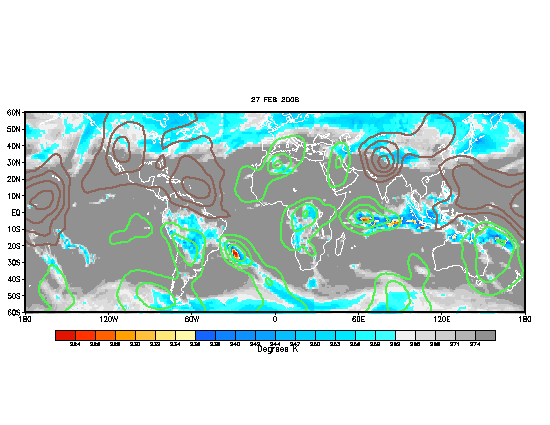
MJO is VERY FAVORABLE near the wave midway between antilles
and Africa.

Image
Last edited by Tampa Bay Hurricane on Thu Aug 11, 2005 8:12 pm, edited 2 times in total.
0 likes   

User avatar
Ivanhater
Storm2k Moderator
Storm2k Moderator
Posts: 11166
Age: 38
Joined: Fri Jul 01, 2005 8:25 am
Location: Pensacola

#4 Postby Ivanhater » Thu Aug 11, 2005 7:31 pm

i still say the one further west looks good
0 likes   

User avatar
Tampa Bay Hurricane
Category 5
Category 5
Posts: 5598
Age: 37
Joined: Fri Jul 22, 2005 7:54 pm
Location: St. Petersburg, FL

#5 Postby Tampa Bay Hurricane » Thu Aug 11, 2005 7:31 pm

Whoops I was referring to the wrong wave....oh well it's been edited/
0 likes   

User avatar
boca
Category 5
Category 5
Posts: 6400
Age: 61
Joined: Mon Dec 15, 2003 8:49 am
Location: Boca Raton,FL

#6 Postby boca » Thu Aug 11, 2005 7:32 pm

The one further west will track like Emily since its so low in latitude and if it develops.
0 likes   

User avatar
Tampa Bay Hurricane
Category 5
Category 5
Posts: 5598
Age: 37
Joined: Fri Jul 22, 2005 7:54 pm
Location: St. Petersburg, FL

#7 Postby Tampa Bay Hurricane » Thu Aug 11, 2005 7:33 pm

but boca the ridge is weaker so it could still get a little closer to me than Emily did...
0 likes   

User avatar
cycloneye
Admin
Admin
Posts: 148499
Age: 69
Joined: Thu Oct 10, 2002 10:54 am
Location: San Juan, Puerto Rico

#8 Postby cycloneye » Thu Aug 11, 2005 7:44 pm

boca wrote:The one further west will track like Emily since its so low in latitude and if it develops.


That central atlantic one does not have low pressure.

What this Far Eastern Atlantic wave is injecting moist air very far north in west Africa and that will help waves that will emerge behind to have a less dry enviroment.
0 likes   
Visit the Caribbean-Central America Weather Thread where you can find at first post web cams,radars
and observations from Caribbean basin members Click Here

User avatar
Ivanhater
Storm2k Moderator
Storm2k Moderator
Posts: 11166
Age: 38
Joined: Fri Jul 01, 2005 8:25 am
Location: Pensacola

#9 Postby Ivanhater » Thu Aug 11, 2005 7:47 pm

cycloneye wrote:
boca wrote:The one further west will track like Emily since its so low in latitude and if it develops.


That central atlantic one does not have low pressure.

What this Far Eastern Atlantic wave is injecting moist air very far north in west Africa and that will help waves that will emerge behind to have a less dry enviroment.


actually i think it does have a broad low pressure....steve lyons said that last night
0 likes   

User avatar
johngaltfla
Category 5
Category 5
Posts: 2072
Joined: Sun Jul 10, 2005 9:17 pm
Location: Sarasota County, FL
Contact:

#10 Postby johngaltfla » Thu Aug 11, 2005 8:27 pm

cycloneye wrote:
boca wrote:The one further west will track like Emily since its so low in latitude and if it develops.


That central atlantic one does not have low pressure.

What this Far Eastern Atlantic wave is injecting moist air very far north in west Africa and that will help waves that will emerge behind to have a less dry enviroment.


Thank you for that information. I never thought about that angle until you made this post. That's why I come here, to learn more every day.

And to make sure I have my plywood nearby. :D
0 likes   

User avatar
Hyperstorm
Category 5
Category 5
Posts: 1500
Joined: Sun Sep 07, 2003 3:48 am
Location: Ocala, FL

#11 Postby Hyperstorm » Thu Aug 11, 2005 9:25 pm

Folks, let's get ready for the train which is about to leave the station...

We have not one or two, but *THREE* POWERFUL waves that are located from the coastline of Africa to just inland over the continent.

The wave that just moved offshore today has had all the characteristics of being a CV cyclone (strong rotation/convection, i.e. MCS), but had the STRONG SAL against it. The wave is still there with a low near 15N and what looks like a MLC WELL north of the convection. I would watch it as it moves farther west, but I don't see development over the Eastern Atlantic due to the SAL.

Now let's jump to the other side of the story...

This rather strong system is filling the way with golden energy for the rest to pick up as they travel westward. What does that mean? The system is increasing the moisture levels over Western Africa due to its high amplitude. There is a very powerful little system (MCS) located inland near 13N, 10W. This system is VERY similar to the one that just moved offshore, but the BIG difference is that it has much more moisture to work with. There's another MUCH larger system located well inland which has a VIGOROUS squall line signature ahead of it, which is signs of a very powerful rotational engine.

I won't tell which one I think will develop, BUT they have to definitely be monitored carefully because conditions are RIPE for them to spin up.

This coincides GREATLY with the wet MJO that is entering the Atlantic and...

Hurricane Season 2005 is about to really begin...
0 likes   

User avatar
cycloneye
Admin
Admin
Posts: 148499
Age: 69
Joined: Thu Oct 10, 2002 10:54 am
Location: San Juan, Puerto Rico

#12 Postby cycloneye » Thu Aug 11, 2005 9:30 pm

Hyperstorm wrote:Folks, let's get ready for the train which is about to leave the station...

We have not one or two, but *THREE* POWERFUL waves that are located from the coastline of Africa to just inland over the continent.

The wave that just moved offshore today has had all the characteristics of being a CV cyclone (strong rotation/convection, i.e. MCS), but had the STRONG SAL against it. The wave is still there with a low near 15N and what looks like a MLC WELL north of the convection. I would watch it as it moves farther west, but I don't see development over the Eastern Atlantic due to the SAL.

Now let's jump to the other side of the story...

This rather strong system is filling the way with golden energy for the rest to pick up as they travel westward. What does that mean? The system is increasing the moisture levels over Western Africa due to its high amplitude. There is a very powerful little system (MCS) located inland near 13N, 10W. This system is VERY similar to the one that just moved offshore, but the BIG difference is that it has much more moisture to work with. There's another MUCH larger system located well inland which has a VIGOROUS squall line signature ahead of it, which is signs of a very powerful rotational engine.

I won't tell which one I think will develop, BUT they have to definitely be monitored carefully because conditions are RIPE for them to spin up.

This coincides GREATLY with the wet MJO that is entering the Atlantic and...

Hurricane Season 2005 is about to really begin...


As always a great discussion that you do about what is going on in that part of the world.Yes MJO is turning more favorable just in time for the real season to start.
0 likes   
Visit the Caribbean-Central America Weather Thread where you can find at first post web cams,radars
and observations from Caribbean basin members Click Here

User avatar
Swimdude
Category 5
Category 5
Posts: 2270
Joined: Mon Jul 26, 2004 11:57 am
Location: Houston, TX

#13 Postby Swimdude » Thu Aug 11, 2005 9:31 pm

Hmmm this is very interesting. Will probably be mentioned in the TWO's henceforth. Let's see if anything develops. However true, it will be a fish. Oh well. Jose is Jose!
0 likes   

User avatar
johngaltfla
Category 5
Category 5
Posts: 2072
Joined: Sun Jul 10, 2005 9:17 pm
Location: Sarasota County, FL
Contact:

#14 Postby johngaltfla » Thu Aug 11, 2005 9:35 pm

With that great discussion, it deserves a pic for others to see. It really adds emphasis to what was said above:

Image
0 likes   

User avatar
Swimdude
Category 5
Category 5
Posts: 2270
Joined: Mon Jul 26, 2004 11:57 am
Location: Houston, TX

#15 Postby Swimdude » Thu Aug 11, 2005 9:45 pm

Very impressive global view. You can definately see the LLC.
0 likes   

sma10
Category 5
Category 5
Posts: 1712
Joined: Tue Aug 02, 2005 1:13 pm

#16 Postby sma10 » Thu Aug 11, 2005 9:49 pm

johngaltfla wrote:With that great discussion, it deserves a pic for others to see. It really adds emphasis to what was said above:

Image


This is a nice picture, but it's nothing unusual. Maybe I'm crazy, but I've been following the tropics for many years; this is what the Africa satellite looks like every August and September.
0 likes   

User avatar
Hyperstorm
Category 5
Category 5
Posts: 1500
Joined: Sun Sep 07, 2003 3:48 am
Location: Ocala, FL

#17 Postby Hyperstorm » Fri Aug 12, 2005 6:18 pm

The wave train is just about ready to head off the coast. Watch for the 2 waves coming off Africa over the next few days...
0 likes   

User avatar
caribepr
Category 5
Category 5
Posts: 1794
Joined: Fri Sep 05, 2003 10:43 pm
Location: Culebra, PR 18.33 65.33

#18 Postby caribepr » Fri Aug 12, 2005 6:39 pm

sma10 wrote:[quote=

This is a nice picture, but it's nothing unusual. Maybe I'm crazy, but I've been following the tropics for many years; this is what the Africa satellite looks like every August and September.


I don't think it's crazy to pay strong attention to what we DO see every August and September (and October AND November) when it can have, in a week or so, a strong impact on our lives. Some will, some won't, obviously - but to not be aware (not crazed - AWARE) and watch would be crazy to me.
0 likes   

User avatar
Hyperstorm
Category 5
Category 5
Posts: 1500
Joined: Sun Sep 07, 2003 3:48 am
Location: Ocala, FL

#19 Postby Hyperstorm » Sat Aug 13, 2005 6:53 am

All factors continue in place for the start of the CV season...

The three strong tropical disturbances extending from the Eastern Atlantic to just inland over Africa are continuing to move westward.

The system further west that moved off Africa during the past 48 hours has a VIGOROUS circulation associated with it right over the CV islands. It has a very high amplitude, but it is situated in the middle of the SAL and over cool SSTs and no convection over the broad center. It will have to be monitored because these high-amplitude systems often develop when they reach the Western Atlantic, if the environment is favorable. Some disturbances that developed just like this, were Hurricane Danny in 2003 and Hurricane Dennis in 1999, just to name some examples. The environment ahead of it doesn't look too favorable for development as it will be encountering a Mid-Oceanic trough of low pressure, so development, if any will be slow.

I repeat again, that what this system has done is increase the moisture levels over Western Africa for a short while. This will allow the other two systems to move offshore in a relatively unstable environment. The system that was poised to move offshore next is now situated near 14N, 17W. It just about to exit into the Atlantic. This system, while fairly tight, has a strong rotation with it. There's only one problem, though, that may hinder its development. It is currently being SQUASHED by a vigorous wave that will be the next one to exit the coast.

That 3rd system has a strong MLC (at least) and the center is located near 10-11N, 5W. It has a strong squall line ahead of it, which has reached the other disturbance, and may encompass it into its larger scope. This is the one I'm watching for possible development (although nothing is imminent in the tropics), it is the best candidate for development right now (outside of 96L). It is in a low latitude (10-11N), it will be moving over SSTs of 83* and higher, SAL will not be a problem, and shear values are about as low as you can get them to be over the far Eastern Atlantic.

I think that there will be good news if this system develops. There is a large-scale trough in the Central Atlantic, that will basically take anything that develops and move it NW towards it. Let's hope to see that happen.
0 likes   

User avatar
Hyperstorm
Category 5
Category 5
Posts: 1500
Joined: Sun Sep 07, 2003 3:48 am
Location: Ocala, FL

#20 Postby Hyperstorm » Sun Aug 14, 2005 9:55 am

I'm going to be fairly brief now because I just finished writing a post and my server went down, so everything was erased. Oh, how I love computers!

A few things have occured over the past 24 hours in the Eastern Atlantic Ocean.

The first tropical wave that exited the coast a few days ago is located WSW of the CV islands. There is currently very scattered pop-up convection developing near 15N, 30W. This is more likely due to the system approaching the mid-ceanic trough and it being in the favorable environment for thunderstorm development, which is East and SE of these systems. This system had a vigorous MLC a few days ago and there are signs we will see stronger convection with this system as it travels over the open Atlantic over the next few days. The environment ahead of it is marginally favorable at best, but if the system manages to move into an environment of less hostility, it will have to monitored because, as I mentioned earlier, these type of high-amplitude waves have a tendency to develop down the road once they get out of the environment near the CV islands, which is of SAL and cool SSTs.

The second small MCS that moved off the coast yesterday has totally dissipated. This system was squashed by a fairly powerful wave that is ready to move offshore. The leading squall line associated with this next wave totally disrupted the inflow of the circulation.

This next wave is a fairly vigorous system. Don't be mislead by the weakening of convection over the past couple of days because the system is still strong and, in fact, convection is re-developing on the southern edge of it that is now over water. The main core is still located near 9-10N, 12W and there appears to be a developing low pressure near those coordinates. This system has slowed down over the past 24-36 hours, but the main core should come off the coast tomorrow at the earliest. There is currently yet another surge of SAL coming off Africa that is located East and NE of the CV islands, but it appears this will be far enough north to affect the system directly.

Even though nothing is imminent in the tropics, much less over the Eastern Atlantic, this system is worthy of monitoring because I think it will be a good candidate for development down the road...
0 likes   


Return to “Talkin' Tropics”

Who is online

Users browsing this forum: Europa non è lontana and 278 guests